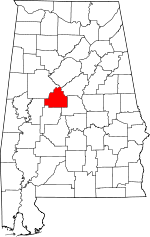
Bibb County, Alabama Basics:
Bibb County Alabama - Government Site
Population: 22,662
Area: 623 square miles
County seat: Centreville
Area code(s) in use: 205 334
Time zone: CST
High school graduate or higher: 76.1%
Bachelor's degree or higher: 9.0%
Median household income: $36,824
Persons in poverty: 16.5%
Home ownership rate: 81.0%
Mean travel time to work: 28.4 minutes
Adjacent counties:
Chilton Hale Jefferson Perry Shelby Tuscaloosa
Places in Bibb County, Alabama
Bibb County Airport Bulldog Bend Fitch Bridge,
Howard Cooper Bridge,
Pratt Ferry Bridge Bibb Correctional Facility,
Bibb County Courthouse,
Bibb County Sheriff's Office,
Bibb Old County Hall (historical),
Brent Police Department,
Brent Volunteer Fire Department,
Brent-Centreville Public Library,
Brierfield Volunteer Fire Department,
Cahaba Wildlife Management Area Headquarters,
Cedar Grove Fire Department,
Centreville Police Department,
Centreville Volunteer Fire Department,
Eoline Volunteer Fire Department Station 1,
Eoline Volunteer Fire Department Station 2,
Green Pond Volunteer Fire Department Station 1,
Green Pond Volunteer Fire Department Station 3,
Lawley Volunteer Fire Department Station 1,
Lawley Volunteer Fire Department Station 2,
Randolph Volunteer Fire Department,
West Blocton Fire Department,
West Blocton Police Department Antioch Cemetery,
Ashby Cemetery,
Avery Cemetery,
Banks Cemetery,
Belchers Cemetery,
Bethel Cemetery,
Bibbville Cemetery,
Boyd Cemetery,
Boyd Cemetery,
Brent Cemetery,
Brierfield Cemetery,
Burns Cemetery,
Caffee Cemetery,
Cahaba Valley Cemetery,
Camp Branch Cemetery,
Carlton Hill Cemetery,
Cedar Grove Cemetery,
Centreville Memorial Cemetery,
Clements Cemetery,
Community Cemetery,
Cottingham Cemetery,
Cox Chapel Cemetery,
Crockett McKinney Cemetery,
Daniel Cemetery,
Duff Cemetery,
Ebenezer Cemetery,
Elam Cemetery,
Enon Cemetery,
Friday Cemetery,
Friendship Cemetery,
George Stewart Cemetery,
Griffin Cemetery,
Haysop Cemetery,
Hebron Cemetery,
Hickory Hill Cemetery,
Hillcrest Cemetery,
Hopewell Cemetery,
Hubbard Cemetery,
Hubbard Springs Cemetery,
Italian Catholic Cemetery,
James Cemetery,
Johnstown Cemetery,
Kinard Cemetery,
Liberty Cemetery,
Little Cemetery,
Little Hope Cemetery,
Mathis Cemetery,
McCulley Cemetery,
McKensey Cemetery,
Moffat Cemetery,
Moore Cemetery,
Mount Carmel Cemetery,
Mount Gilead Cemetery,
Mount Zion Cemetery,
Mulberry Cemeteries,
New Prospect Cemetery,
Perkins Cemetery,
Pineland Memorial Park,
Pleasant Hill Cemetery,
Pondville Cemetery,
Randolph Cemetery,
Rehobeth Cemetery,
Sandy Cemetery,
Sandy Chapel Cemetery,
Schultz Creek Cemetery,
Scottsville Cemetery,
Scottsville Cemetery,
Shady Grove Cemetery,
Shady Grove Cemetery,
Shiney Rock Cemetery,
Six Mile Cemetery,
Six Mile Presbyterian Cemetery,
Stewart Cemetery,
Tabernacle Cemetery,
Thompson Cemetery,
Thrasher Cemetery,
Union Cemetery,
Union Cemetery,
Vernon Cemetery,
Weldon Cemetery,
Wesley Chapel Cemetery,
Williams Cemetery Active Bible Methodist Church,
Ada Chapel,
Antioch African Methodist Episcopal Church,
Antioch Missionary Baptist Church,
Ashby Missionary Baptist Church,
Banks Chapel Baptist Church,
Belle Ellen Baptist Church (historical),
Bethel Baptist Church,
Bibbville Baptist Church,
Blocton Third Baptist Church, Braehead First Baptist Church (historical),
Brent Baptist Church,
Brent Church of God,
Brent Presbyterian Church,
Brierfield Baptist Church,
Cahaba Valley Missionary Baptist Church,
Calvary Baptist Church,
Camp Branch Baptist Church,
Carlton Hill Baptist Church,
Cedar Grove Missionary Baptist Church,
Centreville Baptist Church,
Centreville First Presbyterian Church,
Centreville United Methodist Church, Coleanor Baptist Church (historical),
Community Baptist Church,
Cottingham Church,
Cox Chapel United Methodist Church,
Ebenezer Baptist Church,
Enon Missionary Baptist Church,
Eoline Baptist Church,
Eoline Church,
Four Points Baptist Church,
Friendship Church,
Goodhope Baptist Church,
Grace Bible Church,
Green Pond Baptist Church,
Green Pond Presbyterian Church,
Haysop Church,
Haysop Missionary Baptist Church,
Hopewell African Methodist Episcopal Church,
Hopewell Primitive Baptist Church,
Hubbard Springs Free Will Baptist Church,
Johnstown Baptist Church,
Liberty Free Will Baptist Church,
Lilly Hill Church,
Little Hope Primitive Baptist Church,
Lowerytown Baptist Church,
Lucille Baptist Church,
Marvel Baptist Church,
Marvel Church,
McCulley Hill Baptist Church,
Mills Church,
Mount Carmel Baptist Church,
Mount Gilead Baptist Church,
Mount Grove Baptist Church,
Mount Moriah Baptist Church,
Mount Nebo Baptist Church,
Mount Olive Baptist Church,
Mount Olive Church,
Mount Tabor Baptist Church,
Mount Zion Missionary Baptist Church,
Mulberry Missionary Baptist Church,
New Hebron Baptist Church,
New Hope Baptist Church,
New Prospect Methodist Church, Norris Baptist Church (historical),
North Bibb Church of Christ,
Pine Grove Church,
Pineview Baptist Church, Piper Baptist Church (historical),
Pleasant Hill Presbyterian Church,
Pleasant Sabine Baptist Church,
Pleasant Valley Baptist Church,
Pondville Baptist Church,
Pondville United Methodist Church,
Randolph Baptist Church,
Rehobeth Baptist Church,
Rehobeth Church,
Ridgeville Church,
Rising Star Baptist Church,
Saint Mark Catholic Church (historical),
Saints Assembly Church,
Sandy Chapel United Methodist Church,
Schultz Creek Missionary Baptist Church,
Scottsville Baptist Church, Scottsville Cumberland Presbyterian Church (historical),
Scottsville Union Church,
Shady Grove Baptist Church,
Shady Grove Missionary Baptist Church,
Shiloh Baptist Church,
Siloam Baptist Church (historical), Six Mile Presbyterian Church (historical),
Sixmile Missionary Baptist Church,
Smith Hill Baptist Church,
Southern Methodist Church,
Spencer Nazarene Church, Spring Hill Baptist Church (historical),
Tabernacle United Methodist Church,
Union Baptist Church (historical),
Union Grove Baptist Church,
Union Missionary Baptist Church,
Wesley Chapel United Methodist Church,
West Blocton First Baptist Church,
West Scottsville United Methodist Church,
Woodstock Baptist Church,
Woodstock United Methodist Church Blake Ford,
Centreville Ferry (historical),
Island Ford,
Light Ford,
Locke Ford,
McGuire Ford,
Mitchell Ford,
Murphys Crossing (historical),
Pine Island Ford,
Pratt Ferry (historical),
Richs Ford,
Shallow Ford,
Smiths Ford,
Youngbloods Ferry (historical) Caddis Lake Dam,
Chase Lake Dam,
Hammermill Paper Company Lake Dam,
Kimberly Clark Paper Company Lake Dam,
Kornegay Lake Dam,
Lightseys Mill Pond Dam,
McKnight Lake Dam,
Pearson Lake Dam,
Robinson Lake Dam,
Shady Grove Dam Number One,
Shady Grove Dam Number Two Goodson Bottoms Pearson Gap Bibb Medical Center Cooper Island Avery Pond (historical),
Beaver Pond,
Blue Hole,
Giles Lake,
Miller Lake Bibb Furnace (historical),
Camp Booth,
Camp Hugh,
Camps Forge (historical),
Centreville Weather Station,
Centreville Work Center,
Chitopeni (historical),
Desmans Camp,
Halls Mill,
Keeton Corner,
Low Gap,
Oakmulgee District Ranger Office,
Scottsville Cotton Mill (historical),
Smith and Thomas Mill (historical),
South Sandy Hunter Camp,
Tico (historical),
West Blocton Water Works Aden Slope Mine, Belle Ellen Number 1 Slope Mine, Belle Ellen Slope Mine, Blockton Mine, Blocton Mine, Blocton Number 11 Slope Mine, Blue Jacket Mine,
Braehead Slope Mine, Cane Creek Number 2 Mine, Carroll Mine, Clifton Mine,
Coffee Creek Slope Mine, Coleanor Number 1 Mine, Coleanor Slope Mine,
Confederate Mine, Dixie Mine,
Evans Rock Slope Mine, Gannsey Mine,
Gardner Mine, George Young Number 2 Mine, Gholson Mine, Hargrove Mine,
Hill Creek Mine, Hill Creek Mine, Jones and Read Mine, Kirchlow Opening Mine, Klondyke Mine, Leland Mine, Marvel Number 2 Slope Mine, Masena Mine, Miller Mine, Milner Mine, Morrill Slope Mine, Norrs Mine,
Peachtree Slope Mine, Pipe Number Three Mine, Piper Slope Mine,
Savage Creek Mine, Smith Mine, Smith Shaft Mine, Track Mine Number 16, Truck Mine Number 5, Youngblood Number 1 Mine
Cahaba Wildlife Management Area,
Reed Brake Research Natural Area,
Ross F Gray Memorial Park,
Tiger Stadium Abercrombie,
Academy Park,
Active,
Antioch,
Ardela (historical),
Ashby,
Banks,
Belchers,
Belle Ellen,
Bibb Mill,
Bibbville,
Big Springs (historical),
Blockton Junc,
Blocton (historical),
Braehead (historical),
Brent,
Brierfield,
Bucktown (historical),
Burmah (historical),
Cadle (historical),
Cane Creek (historical),
Centreville,
Choctaw Hills,
Coleanor,
Corinne (historical),
Cox,
Data (historical),
Duff Settlement,
East Centreville,
East Town,
Eddings Town,
Egypt (historical),
Eoline,
Erharkers,
Fairdale,
Fikestown (historical),
Flat Top,
Garnsey,
Garnsey Number 2,
Gary Springs,
Giles,
Goodson,
Gray Hill,
Green Pond,
Hargrove (historical),
Harmon,
Harrisburg,
Hawkinsville (historical),
Hebron,
Ingate,
Italian Town,
Jamesville,
Johnstown,
Lawley,
Little Hope,
Lowerytown,
Lucille,
Marvel,
Masena,
Maud,
McCulley,
McCulley Creek,
McGrawtown,
Mertz,
Moffat,
Nash Town (historical),
New Hargrove (historical),
Nichols (historical),
North Bibb,
Oakley,
Penootaw (historical),
Pilgrim Rest (historical),
Piper,
Pleasant Hill,
Pondville,
Primitive Ridge,
Randolph,
Red Eagle,
Richtown,
River Bend (historical),
Sand Mountain,
Scottsville,
Seymour,
Shawtown,
Sixmile,
Smith Hill,
Spencer,
Stacks Hill (historical),
Stewart Settlement,
Tabernacle,
Thomas Mill,
Trio,
Tucker,
Vernontown,
Vick,
West Blocton,
West Centreville,
Woodstock,
Woodstock Junction,
Zulu Abercrombie Post Office (historical), Active Post Office (historical), Affonee Post Office (historical), Bagley Post Office (historical), Belle Ellen Post Office (historical), Bibb Springs Post Office (historical), Bibbville Post Office (historical), Braehead Post Office (historical),
Brent Post Office,
Brierfield Post Office, Caffee Post Office (historical), Camp Hugh Post Office (historical), Cawdle Post Office (historical),
Centreville Post Office, Coleanor Post Office (historical), Cottongin Post Office (historical), Cox Post Office (historical), Data Post Office (historical), Eoline Post Office (historical), Farrarsville Post Office (historical), Fenwood Post Office (historical), Furnace Post Office (historical), Garnsey Post Office (historical),
Green Pond Post Office, Hargrove Post Office (historical), Harrisburg Post Office (historical), Ingate Post Office (historical), Jamesville Post Office (historical),
Lawley Post Office, Lopez Post Office (historical), Marvel Post Office (historical), Masena Post Office (historical), Mertz Post Office (historical), Modena Post Office (historical), Moffat Post Office (historical), New Mars Post Office (historical), Piper Post Office (historical), Pondville Post Office (historical), Ponoka Post Office (historical),
Randolph Post Office, River Bend Post Office (historical), Sandy Post Office (historical), Scottsville Post Office (historical), Sixmile Post Office (historical), Slick Post Office (historical), Springfield Post Office (historical), Tionus Post Office (historical), Trio Post Office (historical), Vick Post Office (historical), West Blocton Post Office, Willford Post Office (historical),
Woodstock Post Office Halfmile Shoals,
Hargrove Shoals,
Lilly Shoals Bibb County Lake,
Brimwood Lakes,
Crystal Lake,
Hammermill Paper Company Lake,
Jones Lake,
Kimberly Clark Paper Company Lake,
Kornegay Lake,
Lake Ponderosa,
Lightseys Pond,
McKnight Lake,
Robinson Lake,
Rockyview Lake,
Shady Grove Lake Number One,
Shady Grove Lake Number Two,
Shady Grove Lakes Allen P Howison Elementary School,
Banks School,
Bibb County High School,
Bibb County Junior High School,
Bibb County Training School (historical),
Bibb County Vocational School,
Blake School,
Brent Elementary School,
Cahaba Academy, Centreville Academy (historical),
Centreville Elementary School,
Elder School (historical),
Enterprise School,
Eoline Elementary School (historical),
Gray Hill School (historical), Green Pond Academy (historical),
Green Pond Christian School,
Hebron School (historical),
Johnstown School (historical),
Lone Star School (historical),
Mount Tabor Elementary School (historical),
New Hope School (historical),
Pine Grove School (historical),
Rock Institute (historical),
Rock School (historical), Six Mile Academy (historical),
Sixmile School,
Tryon School (historical),
Union School (historical),
Vernontown School (historical),
West Blocton Elementary School,
West Blocton High School, Woodstock Academy (historical),
Woodstock School Morris Spring,
Schultz Creek Church Spring,
Williams Spring Affonee Creek,
Alligator Creek,
Baret Creek,
Bear Branch,
Beaverdam Creek,
Big Branch,
Big Ugly Creek,
Bill Branch,
Bishop Creek,
Black Creek,
Blue Girth Creek,
Brown Branch,
Caffee Creek,
Camp Branch,
Camp Creek,
Cane Creek,
Cave Mountain Branch,
Charley Branch,
Clear Branch,
Clifton Branch,
Coal Branch,
Congo Creek,
Cooper Pasture Branch,
Copperas Creek,
Cottingham Creek,
Daley Creek,
Dry Creek,
Dry Ford Branch,
Dry Hollow Branch,
Flat Creek,
Fourmile Creek,
Furnace Branch,
Galloway Branch,
Gully Creek,
Haggard Creek,
Haysop Creek,
Hill Creek,
Hill Creek,
Holland Branch,
Holsombech Creek,
Horse Branch,
Johnson Creek,
Jones Creek,
Lick Branch,
Licklog Branch,
Little Cahaba River,
Little Cane Creek,
Little Creek,
Little Creek,
Little Mill Creek,
Little Schultz Creek,
Little Ugly Creek,
Lowery Branch,
Mahan Creek,
Maness Creek,
Mayberry Creek,
McCulley Creek,
Middle Branch,
Mill Branch,
Miller Branch,
Mooney Creek,
Mud Creek,
Muddy Branch,
Oldham Creek,
Pine Island Creek,
Pratt Creek,
Ragland Branch,
Reed Arm Branch,
Reedy Branch,
Rocky Branch,
Sandy Creek,
Schultz Creek,
Sixmile Creek,
Smelly Creek,
Smith Creek,
Stone Quarry Branch,
Tanyard Branch,
Taylor Creek,
Trail Branch,
Undermine Creek,
Walker Branch,
Wiggins Creek,
Yeager Branch Big Mountain,
Cave Mountain,
Fountain Hill,
Gray Hill,
Little Mountain,
Sand Mountain,
Soap Hill,
Wheeler Mountain Bibb Lookout Tower,
Marvel Water Tower,
Pondville Lookout Tower,
WBIB-AM (Centreville),

