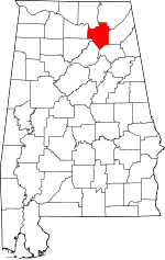
Marshall County, Alabama Basics:


Marshall County Alabama - Government Site

Population: 94,413
Area: 566 square miles
County seat: Guntersville
Area code(s) in use: 256
Time zone: CST
High school graduate or higher: 74.6%
Bachelor's degree or higher: 15.3%
Median household income: $38,649
Persons in poverty: 20.0%
Home ownership rate: 72.0%
Mean travel time to work: 24.4 minutes


Adjacent counties:
Blount  Cullman  Dekalb  Etowah  Jackson  Madison  Morgan  
Find in Alabama

Map of the Marshall County area


Our detail map of Marshall County shows the Marshall County, Alabama boundary lines and other interesting items.

Places in Marshall County, Alabama

  Airports     show all on map

Albertville Regional Airport-Thomas J Brumlik Field, Guntersville Dam Landing Field (historical), Guntersville Municipal Airport - Joe Starnes Field, Smith Landing Field (historical)

  Arches     show all on map

Honeycomb Natural Bridge

  Bars     show all on map

Allens Bar (historical), Beards Bar, Beards Reef, Browns Bar, Buck Island Bar, Coles Bend Bar (historical), Columbus Bar, Gunters Bar, Gunters Reef, Henrys Bar, Lower Bar, Romans Bar, Upper Bar

  Basins     show all on map

Cotton Sinks, Key Basin, Merritt Bottom, Mormon Hole, Norrell Sink, Parches Cove, The Sinks, Wild Goat Cove

  Bays     show all on map

Mill Creek

  Bends     show all on map

Blue Bend, Buck Ford Bend

  Bridges     show all on map

Colvin Bridge, Duckett Bridge, Flats Ford Bridge, Houston Bridge, Mill Pond Bridge

  Buildings     show all on map

Albertville City Hall, Albertville Fire and Rescue Station 1, Albertville Fire and Rescue Station 2, Albertville Fire and Rescue Station 3, Albertville Fire and Rescue Training Facility, Albertville Police Department, Alder Springs Volunteer Fire Department, Arab Fire and Emergency Medical Services Department, Arab Police Department, Asbury Volunteer Fire Department, Beulah Volunteer Fire Department, Boaz City Hall, Boaz Fire and Rescue, Boaz Police Department, Brindlee Mountain Volunteer Fire Department Station 3, Brindlee Mountain Volunteer Fire Department Station 4 Substation, Douglas Volunteer Fire Department, Four Community Volunteer Fire Department, Georgia Mountain Volunteer Fire Department Station 1, Georgia Mountain Volunteer Fire Department Station 2, Grant Fire and Rescue, Grant Police Department, Guntersville City Police Department, Guntersville Fire Rescue Station 1, Guntersville Fire Rescue Station 2, Guntersville Recreation Center, Hebron Volunteer Fire Department, Marshall County Courthouse, Marshall County Courthouse, Marshall County Sheriff's Office, Marshall Medical Professional Center, Mount Hebron Volunteer Fire Department, Nixon Chapel Volunteer Fire Department, Pleasant Grove Volunteer Fire Department, Ruth Volunteer Fire Department, South Sauty Volunteer Fire Department, Swearengin Volunteer Fire Department, Union Chapel Community Center, Union Grove Volunteer Fire Department, Wakefield Community Center, Wakefield Volunteer Fire Department, Waterfront Fire Department

  Capes     show all on map

Berry Point, Bethune Point, Fulks Point, Hale Point, Redbud Point, Signal Point, Simpson Point, Troup Point, Uncle George McLean Point, Williams Point, Wright Point

  Cemeteries     show all on map

Abel Cemetery, Alder Springs Cemetery, Arab City Cemetery, Asbury Cemetery, Ashburn Cemetery, Beard Cemetery, Beech Spring Cemetery, Bennett Cemetery, Berry-Brookshire Cemetery, Bethany Cemetery, Bethlehem Cemetery, Bethsaida Cemetery, Beulah Cemetery, Black Cemetery, Blessing Cemetery, Bodine Cemetery, Boyles Cemetery, Brashier Chapel Cemetery, Brookwood Cemetery, Center Point Cemetery, Chandler Cemetery, Clear Creek Cemetery, Clear Springs Cemetery, Click Cemetery, Cochrane Cemetery, Concord Cemetery, Concord Cemetery, Cooley Cemetery, Cooper Cemetery, Cox Cemetery, Crestview Cemetery, Douglas Cemetery, Dunlap Cemetery, Dunn Cemetery, Eason Johnson Cemetery, Fairview Cemetery, Fairview Cemetery, Free Home Church Cemetery, Friendship Cemetery, Gilliam Springs Cemetery, Griffin Cemetery, Guntersville City Cemetery, Haney Chapel Cemetery, Happy Home Cemetery, Hayden Cemetery, Henry Cemetery, Henryville Cemetery, High Point Cemetery, Hillcrest Cemetery, Hines Cemetery, Honey Cemetery, Honeycomb Cemetery, Humpton Cemetery, Johnson Cemetery, Johnson Cemetery, Kennamer Cemetery, King Chapel Cemetery, Kirby Cemetery, Kirby Cemetery, Kirkland Cemetery, Liberty Hill Cemetery, Little Branch Cemetery, Little Branch Cemetery, Lowry Cemetery, Martling Cemetery, McCamy Cemetery, McDonald Cemetery, McFarland Cemetery, McFarlane Cemetery, Memorial Hill Cemetery, Morris Cemetery, Mount Carmel Cemetery, Mount Hebron Cemetery, Mount High Cemetery, Mount Moriah Cemetery, Mount Oak Cemetery, Mount Olive Cemetery, Mount Olive Cemetery, Mount Tabor Cemetery, Myrtletree Cemetery, Nearen Cemetery, New Brashiers Chapel Cemetery, New Clear Creek Cemetery, New Friendship Cemetery, New Macedonia Cemetery, New Mount Vernon Cemetery, Nixons Chapel Cemetery, Oak Grove Cemetery, Oak Hill Cemetery, Old Albertville Cemetery, Old Cemetery, Old Mount Vernon Cemetery, Old Union Cemetery, Panquin Cemetery, Patterson Cemetery, Pisgah Cemetery, Pleasant Grove Cemetery, Polly Cemetery, Preston Cemetery, Prospect Cemetery, Prospect Cemetery, Rainey Cemetery, Red Apple Cemetery, Red Hill Cemetery, Rehobeth Cemetery, Rice Cemetery, Ridgway Cemetery, Rock Springs Cemetery, Roden Cemetery, Rooks Cemetery, Shiloh Cemetery, Shoal Creek Cemetery, Short Cemetery, Smith Cemetery, Smith Cemetery, Stewart Cemetery, Street Cemetery, Street Cemetery, Sweet Home Cemetery, Taylor Cemetery, Thomason Cemetery, Troup Cemetery, Troup Cemetery, Union Cemetery, Union Cemetery, Union Grove Cemetery, Walker Cemetery, Warrenton Cemetery, White Oak Cemetery, Willis Cemetery, Woosley Cemetery, Zion Hill Cemetery

  Census     show all on map

Cherokee Tribe of Northeast Alabama State Designated Tribal Statistical Area, United Cherokee Ani-Yun-Wiya Nation State Designated Tribal Statistical Area

  Churches     show all on map

Alder Springs Church, Alder Springs Cumberland Presbyterian Church, Antioch Church, Asbury Methodist Church, Ashbury Church (historical), Baker Chapel, Beech Creek Church (historical), Beech Spring Church, Bel Air Baptist Church, Bethany Baptist Church, Bethel Church, Bethlehem Church, Bethsaida Baptist Church, Beulah Baptist Church, Beulah Church, Blessing Church of Christ, Boaz Church of God, Boaz First Baptist Church, Boaz Second Baptist Church, Bond Chapel, Brashier Chapel, Brock Chapel, Calvary Church, Carbinville Church, Center Church, Center Point Church, Center Star Church, Central Church, Church of Christ, Church of Christ (historical), Claysville Church, Clear Creek Primitive Baptist Church, Clear Springs Church, Concord Baptist Church, Concord Baptist Church, Corinth Church, Crestview Church of Christ, Diamond Church, Douglas Baptist Church, Douglas Methodist Church, Eddy Baptist Church, Ephesus Church, Esky Grove Church (historical), Fairview Church, Fairview Church, Fairview Church (historical), Fairview Church (historical), First Baptist Church, First Baptist Church, First Methodist Church, Forrest Home Church, Free Home Baptist Church, Friendship Baptist Church, Gethsemane Church, Gilliam Springs Baptist Church, Grant Church, Grassy Church, Grassy Church (historical), Grassy Mountain Church, Hampton Grove Church, Hanaville Church, Haney Chapel, Happy Home Church, Harding Chapel (historical), Haygood Church, Hebron Church, Henryville Church, High Point Baptist Church, High Point Church, Hills Chapel, Holiness Church (historical), Holly Grove Church, Honeycomb Church, Honeycomb Church (historical), Hustleville Church, Independent Church, Johnson Chapel (historical), Julia Street Methodist Church, Kelly Chapel, Liberty Church, Liberty Hill Church, Lifegate Church, Little Branch Church, Little Branch Church, Little Branch Primitive Baptist Church, Martling Church, Martling Church, Maxwell Church (historical), Missionary Church (historical), Mobbs Church (historical), Mount Calvary Baptist Church, Mount Carmel Church, Mount Hebron Baptist Church, Mount Hebron Church, Mount High Church, Mount High Primitive Baptist Church, Mount Moriah Methodist Church, Mount Oak Methodist Church, Mount Olive Baptist Church, Mount Olive Church, Mount Olive Church of Christ, Mount Pisgah Primitive Baptist Church, Mount Pleasant Church (historical), Mount Sinai Church, Mount Tabor Baptist Church, Mount Vernon Church, Mount View Church, Mount Zion Church, Myrtletree Baptist Church, Nan Roberts Lane Chapel Church, New Brashier Chapel, New Brashier Church, New Clear Creek Primitive Baptist Church, New Friendship Church, New Home Church, New Home Church, New Hope Church, New Macedonia Missionary Baptist Church, Nixon Chapel Church, North Parkway Church, Oak Grove Church, Oak Grove Church, Oak Grove Church, Oak Grove Methodist Church, Oak Hill Baptist Church, Old Fairview Church, Old Union Church, Oleander Church, Pilgrim Rest Baptist Church, Pilgrims Rest Primitive Baptist Church, Pine Grove Church, Pine Grove Church (historical), Pine Island Church, Piney Grove Church, Piney Grove Church, Pleasant Grove Missionary Baptist Church, Pleasant Hill Church, Pleasant Valley Church, Pleasant Valley Church, Poplar Springs Church, Poplar Springs Church, Prospect Church, Prospect Church, Red Apple Missionary Baptist Church, Red Hill Church, Red Hill Methodist Church, Rehobeth Missionary Baptist Church, Rock Springs Church, Rockdale Church, Rocky Mount Primitive Baptist Church, Ruth Baptist Church, Saint Paul Methodist Church, Sandridge Church, Scotts Chapel (historical), Shiloh Church, Shiloh Church, Shoal Creek Church, Simpson Point Church, Snead Chapel, Solid Rock Church, Solitude Church, South Sauty Church, Spring Mountain Church, Springdale Baptist Church, Swearengin Church, Sweet Home Baptist Church, Union Chapel Church, Union Chapel Church, Union Church, Union Church, Union Grove Baptist Church, Valley View Church, Warrenton Church, Warrenton Church, Welcome Bethel Church, Welcome Home Church, Welcome Home Church, Wesley Chapel, West Side Baptist Church, Westside Baptist Church, White Oak Church, Whitesville Church, Zion Hill Primitive Baptist Church

  Cliffs     show all on map

Ballew Point, Bean Rock Bluff, Big Rock, Black Bluff, Blue Rock Bluff, Honey Bluff, Long Point, Mill Bluff, Painted Bluff, Short Creek Bluff, Street Bluff, Thrasher Bluff, Whittaker Narrows

  Crossings     show all on map

Bean Rock Ferry (historical), Buck Ford, Columbus City Ferry (historical), Creek Ford, Fort Deposit Ferry (historical), Guntersville Ferry (historical), Honey Ferry (historical), Maple Ford, Stapler Ford, Town Creek Ferry (historical)

  Dams     show all on map

Guntersville Dam, Little Paint Creek Lake Dam, Pine Lake Dam

  Falls     show all on map

Piney Branch Falls, Ragsdale Falls, Short Creek Falls, Thompson Falls

  Flats     show all on map

Chestnut Flat

  Gaps     show all on map

Black Gap, Cox Gap, Fry Gap, Harrison Gap, King Gap, Light Gap, Lucas Gap, Ricketts Gap, Saylor Gap, Shaver Gap, Smith Gap, The Narrows, The Narrows, Thompson Falls Gap, Village Ford Gap, Winston Gap, Word Gap

  Hospitals     show all on map

Arab Hospital, Boaz Nursing Home, Guntersville Hospital, Marshall County Nursing Home, Marshall Medical Center North, Marshall Medical Center South, Sand Mountain Infirmary (historical)

  Islands     show all on map

Buck Island, Buck Island (historical), Goat Island, McKee Island (historical), Pine Island (historical)

  Lakes     show all on map

Black Lake (historical), Moore Pond (historical), Smith Lake, White Lake (historical)

  Locales     show all on map

Alabama Christian Youth Camp, Albertville Country Club, Albertville-Boaz Water Supply, Alred Marina, Arab Country Club, Arbor Acres Farm, Bean Rock, Bean Rock Landing (historical), Birmingham YMCA Camp, Blacks Landing (historical), Blue Rock Landing (historical), Bobby Briscoe Farms, Brazill Mill (historical), Camp Ney A Ti, Camp Trico, Center Point, Cha-La-Kee YMCA Camp, Chunns Store (historical), Coal Landing (historical), Columbus City Landing (historical), Davidsons Landing (historical), Deposit Landing (historical), Dream Ranch, Ellenbergs Mill (historical), Ferguson Farms, Finlay Plaza Shopping Center, Fosters Landing (historical), Fowlers Mill (historical), Gunter Landing (historical), Guntersville Lake Yacht Club, Guntersville Marina, Harvells Store (historical), Hillian Store (historical), Honey Landing (historical), Honeycomb Snug Harbor, Joey Baker Poultry Farm, John H Burden Dairy, Johnsons Store (historical), Kirkland Farms, Lake Shopping Center, Law Landing (historical), Little Mountain Marina, Lovelace Landing (historical), Mahans Store (historical), Mannings Store (historical), Marshall Baptist Camp, Marshall County Farm (historical), Martin Farm, Morgans Store (historical), Mountain Gap, Old Barclay Mill, Old Center, Paint Rock Landing (historical), Pine Island Landing (historical), Preston Cabin Site Area, Riverbend Marina, Riverview Campground, Roman Landing (historical), Saint Bernard College Camp, Shadowfax Farm, South Gate Shopping Center, South Sauty Point Cabin Site Area, Speers Landing (historical), Spring Creek Marina, Street Bluff Boat Dock, Sunrise Farms, Sycamore Landing (historical), The Y, Tidwells Store (historical), Turner Marina, Val Monte Country Club, Val Monte Marina, Williams Marina

  Parks     show all on map

Big Spring Creek Small Wild Area, Bucks Pocket Tri-County Park, Cave Mountain Small Wild Area, David Crockett Visit Lions Club Park, Guntersville Municipal Park, Lake Guntersville State Park, Lindsey-Honeycomb Creek Wild Area, Marshall County Park, Ogletree Park, Tom Jackson Park, Yogi Bears Jellystone Park

  Pillars     show all on map

Wyeth Rock

  Populated Places     show all on map

Albertville, Alder Springs, Alexander Subdivision, Allens Crossroads, Arab, Asbury, Askea Grove, Bartlett (historical), Big Spring (historical), Big Spring Creek Subdivision, Black Center, Boaz, Bowen (historical), Breezeway Bay, Buck Island Shores, Buck Island Subdivision, Bucksnort, Campbell Mill, Claysville, Columbus City, Corbinville, Cottonville, Country Club Estates, Crossroads, Cushion, Diamond, Double Bridges, Double Bridges, Douglas, Eddy, Egypt, Ferns Quarter (historical), Five Points, Fort Deposit (historical), Friendship, Friendship (historical), Glen Haven, Grant, Grassy, Gregory (historical), Guntersville, Guntersville Shores, Half Acre Estates, Hayes Branch Subdivision, Hebron, Henryville, Hide Away Acres, High Point, Hog Jaw, Holiday Shores, Honeycomb Park, Horton, Humpton, Hustleville, Hyatt, Jink (historical), Johnson (historical), Johnsons Mill, Keel (historical), Kirbytown, Lakeview, Lamont (historical), Lane, Lattiwood, Lindsay Lane, Little New York, Lot (historical), Manchester, Marshall, Martling, May Apple (historical), McVille, Meadow Wood, Meadowood, Meltonsville, Mid (historical), Mill Village, Miller Subdivision, Minorville (historical), Morrow Acres, Mount Carmel, Mount Hebron, Mount Olive, Mountain View, Needmore, Neighbors Mill, Nixon Chapel, North (historical), North Arab, Oak Grove, Oleander, Pendergrass, Pendergrass (historical), Peters (historical), Pine Acres, Pine Island Subdivision, Pine Lake Village, Pine Shores, Pinedale Shores, Playground Shores, Pleasant Grove, Point of Pines Subdivision, Poplar Ridge, Poplar Springs, Preston, Preston Sights Subdivision, Preston Subdivision, Rabbit Town, Rayburn, Red Apple (historical), Red Hill, Reedbrake (historical), Rice, Rocky Ridge, Ruth, Sandy Point Subdivision, Saratoga, Scant City, Shady Acres, Sherwood Forest, Sidney, Signal Point Subdivision, Skinner Subdivision, Smith Shores, Southern (historical), Southtown, Star Point Subdivision, Street (historical), Sunrise Shores, Sunset Acres, Swearengin, Tanglewood, Union Grove, Upton (historical), Warrenton, Warrenton Subdivision, White Oak, Whitesville, Woodall Place, Wyeth City

  Post Offices     show all on map

Albertville Post Office, Big Spring Post Office (historical), Grant Post Office

  Reserves     show all on map

Oar Reservation

  Reservoirs     show all on map

Guntersville Lake, Horsley Lake, Lynn Mill Pond, Pine Lake, Spring Lake, Woodland Lake

  Ridges     show all on map

Bailey Ridge, Ben Johnson Ridge, Billy Ridge, Cave Spring Ridge, Cedar Ridge, Chandler Ridge, Dividing Ridge, Kelley Ridge, Lang Mountain, Pea Ridge, Pea Ridge, River Ridge, Rocky Ridge, Roden Ridge, Russell Ridge, Taylor Ridge

  Schools     show all on map

Albertville High School, Albertville Junior High School, Albertville Public School (historical), Alder Springs School (historical), Arab Elementary School, Arab High School, Arab Junior High School, Arab Primary School, Asbury School, Bean Rock School, Bethsaida School (historical), Beulah School (historical), Big Spring Valley School (historical), Blessing School (historical), Blessing School (historical), Boaz Elementary School, Boaz High School, Boaz Junior High School, Braisher Chapel School (historical), Brashier Chapel School (historical), Brock School (historical), Carlisle Junior High School, Cedar Grove School (historical), Cherokee School, Claborn School (historical), Claysville Junior High School, Columbus City School (historical), Corbinville School (historical), Cottonville School (historical), Crossroads School (historical), D A R School, Douglas Elementary School, Douglas High School, Eddy School (historical), Evans School, Five Points School (historical), Flat Rock School (historical), Friendship School (historical), Friendship School (historical), Grassy Junior High School, Guntersville High School, Hampton Grove School (historical), Haney Chapel School (historical), Haney Chapel School Number 2 (historical), Hebron School, Highview School, Honeycomb School (historical), Horton School (historical), Jones Chapel School (historical), Kennemer School (historical), King Chapel (historical), Lakeview Heights School, Lamont School (historical), Lattiswood School (historical), Liberty Hill School (historical), Marshall County High School (historical), Marshall County Technical School, Martling School (historical), Midway School (historical), Mobbs School, Mount Hebron Grammar School (historical), Mount Moriah School (historical), Mount Moriah School (historical), Mount Olive School (historical), Mount Pleasant School, New Howard School (historical), New Prospect School, Nixon Chapel School (historical), Northeast Alabama Agricultural School (historical), Pine Grove School (historical), Pleasant Grove School, Poplar Springs School (historical), Poplar Springs School (historical), Rice School, Rice School (historical), Rock Hill School (historical), Rockdale School (historical), Rocky Ridge School (historical), Ruth School (historical), Simpson Point School (historical), Sims School, Snead College, Solitude School (historical), Union Grove Junior High School, Union School (historical), Warrenton School (historical), Whitesville School (historical)

  Springs     show all on map

Barkley Spring, Beech Spring, Big Spring, Black Spring, Blowing Cave Spring, Clear Spring, Cushion Spring, Daniel Spring, Davidson Spring, Davis Spring, Ferguson Spring, Harris Spring, Honeycomb Spring, Little Blue Spring, McDonald Spring, McGehee Spring, Shell Spring, Skidmore Spring, Smith Spring, Taylor Spring, Ward Spring

  Streams     show all on map

Baker Spring Branch, Bean Rock Creek, Beech Creek, Benson Branch, Berry Branch, Berry Branch, Big Branch, Big Branch, Big Reedbrake Creek, Big Spring Creek, Bitty Branch, Boshart Creek, Brock Branch, Browns Creek, Burns Branch, Busby Branch, Cane Creek, Carl Creek, Carroll Branch, Chandler Branch, Clemons Branch, Collins Creek, Cove Creek, Cranford Branch, Drift Branch, Dripping Spring Branch, Drum Creek, Dry Creek, Duvall Branch, East Fork Drum Creek, Eddy Branch, Fearn Branch, Flat Branch, Gilliam Creek, Hamby Branch, Hayes Branch, Hog Branch, Hog Creek, Hog Jaw Creek, Honeycomb Creek, Horseshoe Creek, Horton Spring Branch, Hurricane Branch, Jagger Branch, Jagger Branch, Jones Branch, Joppa Creek, Lemon Branch, Little Branch, Little Cane Creek, Little Drum Creek, Little Hog Creek, Little Mud Creek, Little Paint Rock Creek, Little Reedbrake Creek, Little Shoal Creek, Little Slab Creek, Long Hollow Branch, Martling Branch, Mayo Branch, McCorkle Branch, Mill Pond Creek, Mine Branch, Mink Creek, Minky Creek, Mormon Hole Branch, Old Union Branch, Owl Creek, Paint Rock River, Peachtree Creek, Perkins Creek, Pigeon Roost Creek, Piney Branch, Polecat Branch, Polk Creek, Proctor Branch, Red Hill Branch, Rocky Branch, Scarham Creek, Seibold Branch, Sheepneck Branch, Shiloh Branch, Shoal Creek, Shoal Creek, Short Creek, Slab Creek, South Sauty Creek, Tacket Branch, Toten Creek, Town Creek, Tremble Creek, Turkey Creek, Whippoorwill Creek, Whitfield Branch, Wolf Creek, Wolf Creek, Yellow Branch, Yellow Creek

  Summits     show all on map

Baker Hill, Bald Knob, Benton Round Mountain, Bettinger Mountain, Bishop Mountain, Black Mountain, Bob Mountain, Cave Mountain, Cedar Mountain, Center Point, Clarksville Mountain, Ellenburg Mountain, Fort Deposit Point, Georgia Mountain, Grassy Mountain, Graveyard Hill, Gullion Mountain, Gunters Mountain, Haney Mountain, Husky Mountain, Jim Cryar Hill, John Doss Mountain, Lewis Mountain, Little Mountain, Martin Hill, McCorkle Mountain, McDermott Mountain, Merrill Mountain, Moores Hill, Murphy Hill, Negro Mountain, Negro Mountain, Noahs Ark, Pisgah Mountain, Pritchett Mountain, Rich Top, Shin Point, Shumate Mountain, Snow Point, Sockfoot, Soda Top, Stubblefield Mountain, Taylor Mountain

  Towers     show all on map

WAVU-AM (Albertville), WBSA-AM (Boaz), WCRQ-FM (Arab), WGSV-AM (Guntersville), WQSB-FM (Albertville), WRAB-AM (Arab), WTWX-FM (Gunthersville), WXBK-AM (Albertville)

  Valleys     show all on map

Basin Cove, Battle Hollow, Big Spring Valley, Bryant Mill Hollow, Bullocks Hollow, Cagle Hollow, Cane Tuck Hollow, Caney Hollow, Chambless Hollow, Cherry Hollow, Click Hollow, Davidson Hollow, Derrick Hollow, Dodds Cove, Fishers Hollow, Fishing Hollow, Fletcher Hollow, Fort Hollow, Greasy Hollow, Greenbriar Cove, Gross Hollow, Guffey Hollow, Hambrick Hollow, Hog Creek Hollow, Jagger Hollow, John Law Hollow, John R Hollow, Johnson Hollow, Jughandle Hollow, Kennamer Cove, Kight Hollow, King Hollow, King Hollow, Kirk Hollow, Ledbetter Hollow, Lindsey Hollow, Long Hollow, McDonald Hollow, Mead Hollow, Mill Hollow, Mill Hollow, Mitchell Hollow, Morgan Cove, Perkins Hollow, Polecat Hollow, Powell Mill Hollow, Pumpkin Hollow, Rice Cove, Rocky Branch Hollow, Roden Valley, Ryan Cove, Slater Hollow, Stillhouse Hollow, Stone Quarry Hollow, Sugar Tree Hollow, Tallman Hollow, Taylor Hollow, Tidwell Hollow, Walley Hollow, Watts Hollow, Willis Hollow, Woodall Hollow, Woodall Hollow, Woods Hollow, Wrights Cove,

Marshall County, Alabama Population By Race (2012 estimate)

RacePopulation
WhiteMarshall County White population 88,93788,937  
BlackMarshall County Black population 2,0772,077
MixedMarshall County Mixed population 1,5111,510
American IndianMarshall County American Indian population 1,0391,038
AsianMarshall County Asian population 661660
Hawaiian & Pacific IslanderMarshall County Hawaiian & Pacific Islander population 283283

Additional population tables :
State population table
Alabama population by county