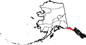
Yakutat Borough, Alaska Basics:


Yakutat Borough Alaska - Government Site

Population: 658
Area: 7649 square miles
Borough seat:
Area code(s) in use: 907
Time zone: PST-1
High school graduate or higher: 93.3%
Bachelor's degree or higher: 32.3%
Median household income: $71,705
Persons in poverty: 3.3%
Home ownership rate: 45.9%
Mean travel time to work: 5.7 minutes


Adjacent counties:

Find in Alaska

Map of the Yakutat Borough area


Our detail map of Yakutat Borough shows the Yakutat Borough, Alaska boundary lines and other interesting items.

Places in Yakutat Borough, Alaska

  Airports     show all on map

Alsek River Airport, Dangerous River Airport, East Alsek River Airport, Harlequin Lake Airport, Icy Bay Airport, Situk Airport, Tanis Mesa Airport, Yakataga Airport, Yakutat Airport, Yakutat Seaplane Base

  Areas     show all on map

Hubbard Glacier Geological Area, Kwik Delta, Yakutat Foreland

  Bars     show all on map

Blacksand Spit, Gilbert Spit, New Reef, New Reefs, Prince Shoal, Tick Shoal, Tzuse Shoal, Village Shoal

  Bays     show all on map

Ahduck Bay, Black Duck Bay, Broken Oar Cove, Chicago Harbor, Deep Bay, Disenchantment Bay, Dry Bay, Eleanor Cove, Gonakadetseat Bay, Graveyard Cove, Humpback Cove, Monti Bay, Nunatak Fiord, Port Mulgrave, Puget Cove, Redfield Cove, Rurik Harbor, Russell Fiord, Sawmill Cove, Sea Otter Bay, Seal Bay, Shelter Cove, Shipyard Cove, The Lagoon, Yakutat Bay

  Beaches     show all on map

Khantaak Beach, Logan Beach, Schooner Beach

  Buildings     show all on map

Alaska State Troopers Yakutat, Khantaak Light, Ocean Cape Light, Southeast Alaska Regional Health Consortium Yakutat Community Health Center, Yakutat Public Safety, Yakutat Volunteer Emergency Medical Services and Rescue, Yakutat Volunteer Fire Department

  Capes     show all on map

Ankau Head, Arrecifes Point, Bancas Point, Blizhni Point, Cape Enchantment, Cape Fairweather, Cape Sitkagi, Cape Stoss, Hatchet Point, Kooisk Point, Marble Point, Northeast Point, Ocean Cape, Phipps Cape, Phipps Peninsula, Point Carrew, Point Latouche, Point Manby, Point Munoz, Point Turner, Puget Peninsula, Punta Cascales, Pyramid Point

  Cemeteries     show all on map

Chief Situk Grave

  Census     show all on map

Yakutat Alaska Native Village Statistical Area, Yakutat Census Designated Place

  Channels     show all on map

Canoe Pass, Hatchet Pass, Johnstone Passage, The Ankau, Yakutat Roads

  Cliffs     show all on map

Logan Bluffs, Sitkagi Bluffs

  Gaps     show all on map

Dome Pass, Floral Pass, Pinnacle Pass

  Glaciers     show all on map

Agassiz Glacier, Alexander Glacier, Alsek Glacier, Alverstone Glacier, Art Lewis Glacier, Atrevida Glacier, Augusta Glacier, Battle Glacier, Beare Glacier, Bering Glacier, Black Glacier, Blossom Glacier, Butler Glacier, Canyon Glacier, Cascade Glacier, Cascading Glacier, Chamberlain Glacier, Coal Glacier, Daisy Glacier, East Nunatak Glacier, Fassett Glacier, Fourth Glacier, Galiano Glacier, Grand Plateau Glacier, Guyot Glacier, Haenke Glacier, Hanging Glacier, Hayden Glacier, Hendrickson Glacier, Henry Glacier, Hidden Glacier, Hitchcock Glacier, Hubbard Glacier, Lare Glacier, Latouche Glacier, Leeper Glacier, Libbey Glacier, Lucia Glacier, Malaspina Glacier, Martin Glacier, Marvine Glacier, McCarty Glacier, Miller Glacier, Miller Glacier, Moser Glacier, Netland Glacier, Novatak Glacier, Orange Glacier, Pinnacle Glacier, Rasmuson Glacier, Rodman Glacier, Sea Otter Glacier, Seward Glacier, Turner Glacier, Tyndall Glacier, Valerie Glacier, Variegated Glacier, Waxell Glacier, West Nunatak Glacier, White River Glacier, Yahtse Glacier, Yakutat Glacier

  Guts     show all on map

Cabin Slough, Johnsons Slough, Middle Slough

  Islands     show all on map

Bear Island, Blacksand Island, Boat Island, Canoe Island, Crab Island, Doggie Island, Dolgoi Island, Fitzgerald Island, Gateway Knob, Gregson Island, Haenke Island, Khantaak Island, Knight Island, Kriwoi Island, Krutoi Island, Neeg Island, Osier Island, Otmeloi Island, Strawberry Island, Tla-xagh Island

  Lakes     show all on map

Agassiz Lakes, Aka Lake, Aka Lake, Akwe Lake, Alsek Lake, Ankau Saltchucks, Hanna Lake, Harlequin Lake, Italio Lake, Kardy Lake, Laguna de la Frezas, Lake Redfield, Lower Doame Lake, Malaspina Lake, Midimber Lake, Mountain Lake, Oily Lake, Rocky Lake, Sacred Lake, Situk Lake, Square Lake, Summit Lake, Summit Lakes, Tanis Lake, Triangle Lake, Upper Doame Lake, Ustay Lake

  Locales     show all on map

Alsek River Cabin, Cannon Beach Picnic Area, East Alsek River Cabin, Harlequin Lake Cabin, Italio River Cabin, Lower Dangerous River Cabin, Middle Dangerous River Cabin, Situk Weir Cabin, Square Lake Cabin, Tanis Mesa Cabin

  Parks     show all on map

Glacier Bay National Preserve, Glory of Russia (historical)

  Populated Places     show all on map

Situk, Situk Village (historical), Yakutat

  Post Offices     show all on map

Yakutat Post Office

  Ranges     show all on map

Brabazon Range, Deception Hills, Floral Hills, Hitchcock Hills, Icefield Ranges, Samovar Hills

  Rapidss     show all on map

First Rapids

  Reserves     show all on map

Russell Fjord Wilderness

  Ridges     show all on map

Pinnacle Pass Hills

  Streams     show all on map

Ahrnklin River, Akwe River, Alder Stream, Alsek River, Antlen River, Aquadulce Creek, Beasley Creek, Calahonda Creek, Cannery Creek, Clear Creek, Clear Creek, Dangerous River, Doame River, East Alsek River, Emile Creek, Esker Stream, Forney Stream, Fountain Stream, Gines Creek, Grand Wash River, Humpback Creek, Indian Camp Creek, Italio River, Kame Stream, Kunayosh Creek, Kwik Stream, Lost River, Lucia Stream, Manby Stream, Miller Creek, Moser Creek, Muddy Creek, Old Situk River, Onklat Creek, Ophir Creek, Osar Stream, Sea Otter Creek, Seal Creek, Shack Creek, Situk River, South Fork Doame River, Split Creek, Sudden Stream, T'awat Creek, Taaltsug River, Tanis River, Tawah Creek, Tlegan River, Ustay River, Vankahini River, West Fork Situk River, Williams Creek

  Summits     show all on map

Amphitheater Knob, Black Tit, Blossom Island, Boundary Peak 184, Boundary Peak 185, Boundary Peak 187, Crescent Mountain, Gilbert Point, Haydon Peak, Lucia Nunatak, Moore Nunatak, Mount Alexander, Mount Alverstone, Mount Armour, Mount Augusta, Mount Aylesworth, Mount Cook, Mount Draper, Mount Duff, Mount Fairweather, Mount Foresta, Mount Hay, Mount Hendrickson, Mount Herbert, Mount Hoorts, Mount Hubbard, Mount Jette, Mount Lodge, Mount Mallott, Mount McCarty, Mount Owen, Mount Pinta, Mount Rasmuson, Mount Reaburn, Mount Root, Mount Ruhamah, Mount Saint Elias, Mount Seattle, Mount Stamy, Mount Tebenkof, Mount Unana, Mount Vancouver, Mount Wade, Mount Watson, Point Glorious, Slate Peak, South Mountain, Terrace Point, The Nunatak

  Towers     show all on map

KJFP-FM (Yakutat),

Yakutat Borough, Alaska Population By Race (2012 estimate)

RacePopulation
WhiteYakutat Borough White population 264263  
American IndianYakutat Borough American Indian population 230230
MixedYakutat Borough Mixed population 103103
AsianYakutat Borough Asian population 3939
Hawaiian & Pacific IslanderYakutat Borough Hawaiian & Pacific Islander population 1615
BlackYakutat Borough Black population 54

Additional population tables :
State population table
Alaska population by county