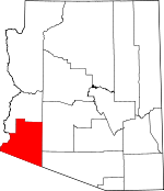
Yuma County, Arizona Basics:


Yuma County Arizona - Government Site

Population: 201,733
Area: 5514 square miles
County seat: Yuma
Area code(s) in use: 928
Time zone: MST
High school graduate or higher: 71.5%
Bachelor's degree or higher: 14.2%
Median household income: $41,156
Persons in poverty: 21.4%
Home ownership rate: 69.6%
Mean travel time to work: 19.1 minutes


Adjacent counties:
Imperial (CA)  La Paz  Maricopa  Pima  
Find in Arizona

Map of the Yuma County area


Our detail map of Yuma County shows the Yuma County, Arizona boundary lines and other interesting items.

Places in Yuma County, Arizona

  Airports     show all on map

Antelope Ranch Airport, Castle Dome Army Heliport, Checkerboard Airport, Colfred Airport, Dateland Airfield, DVR Airport, Fishers Landing Airport, Laguna Army Airfield (Yuma Proving Ground), McDaniel Field, Rolle Airfield, Somerton Airport, Stoval Airfield, Tacna Landing Strip, Wellton Airport, Yuma Helicopters, Yuma Marine Corps Air Station/Yuma International Airport, Yuma Number Four Airfield, Yuma Number One Airfield, Yuma Regional Medical Center Heliport

  Arches     show all on map

Arch Tank Natural Bridge, Conflagration Arch, Gunnery Arch, Natural Arch, Natural Arch, Natural Arch, Natural Arch, Natural Arch, Natural Arch, Natural Arch, Natural Arch, Natural Arch, Natural Arch, Natural Arch, Natural Arch, Natural Arch, Natural Arch

  Areas     show all on map

Gadsden Purchase, Pinta Sands

  Arroyos     show all on map

Papago Wash, Tule Wash

  Basins     show all on map

A-one Basin, Halfway Tank, Pinacate Valley, Virgin Basin

  Benches     show all on map

Muggins Mesa

  Bends     show all on map

Precipice Bend, Reedy Bend, Sleepers Bend

  Bridges     show all on map

McPhaul Bridge

  Buildings     show all on map

Arizona Game and Fish Region IV Office, Arizona State Highway Patrol Yuma District 4, Arizona State Prison Complex Yuma, Carnegie Library, Dateland Library, Emerald Springs Retirement and Assisted Living Community, Growler Railroad Station, Horn Railroad Station, Life Care Center of Yuma, North End Community Center, Palm View Rehabilitation and Care Center, Roll Library, Rural / Metro Fire Department Station 10, Rural / Metro Fire Department Station 11, Rural / Metro Fire Department Station 2, Rural / Metro Fire Department Station 3, Rural / Metro Fire Department Station 5, Rural / Metro Fire Department Station 6, Rural / Metro Fire Department Station 7, Rural / Metro Fire Department Station 8, Rural / Metro Fire Department Station 9, Rural Metro Fire Department Station 1, San Luis Fire Department, San Luis Library, San Luis Police Department, Somerton - Cocopah Fire Department, Somerton City Hall, Somerton Library, Somerton Police Department, Wellton Fire Department, Wellton Library, Wellton Town Hall, Yuma City Hall, Yuma Civic and Convention Center, Yuma County Adult Detention Center, Yuma County Juvenile Home, Yuma County Sheriff's Office District 2, Yuma County Sheriff's Office District 4, Yuma County Sheriff's Office District 5, Yuma County Sheriff's Office Foothills District, Yuma County Sheriff's Office Headquarters, Yuma Courthouse, Yuma Fire Department Station 1, Yuma Fire Department Station 2, Yuma Fire Department Station 3, Yuma Fire Department Station 4, Yuma Fire Department Station 5, Yuma Fire Department Station 6, Yuma Nursing Center, Yuma Police Department, Yuma Railroad Station, Yuma Territorial Prison, Yuma Territorial Prison (historical)

  Canals     show all on map

A 8.4 Lateral, A 8.9 Lateral, A 8.9 N Lateral, A 9.4 Lateral, A Canal, Abbott Lateral, Adams Lateral, Arnold Lateral, Auxiliary Supply Canal, B 3.7 Lateral, B 3.8 Lateral, B 5.5 W Lateral, B 6.2 E Lateral, B 7.0 Lateral, B 8.0 N Lateral, B 8.55 Lateral, B Canal, B Main Lateral, Baker Lateral, Barkley Lateral, Bondesson Lateral, Bronk Lateral, Cahoon Lateral, Carter Lateral, Case Lateral, Central Canal, Central Drain, Central Drain, Central Stub Number One, Central Stub Number Two Drain, Church Lateral, Cloyd Lateral, Cocopah Drain, Converse Lateral, Cooper Lateral, Corey Drain, Coyote Wash Channel, Croft Lateral, Cummings Lateral, Daniel Lateral, Dome Canal, Dome Lateral, Dome Protective Channel, Donovan Lateral, East Central Drain, East Drain, East Drain Extension, East Hearn Lateral, East Main Canal, Edwards Lateral, Ellis Lateral, Farmers Canal, Faulkner Lateral, Fishbaugh Lateral, Flint Lateral, Franklin Lateral, Frates Lateral, Fuller Lateral, Gardenhire Drain, Garven Lateral, George Lateral, Gibson Lateral, Gila Main Canal, Gilbert Lateral, Graham Lateral, Greer Lateral, Groover Lateral, Hanna Lateral, Harmon Lateral, Harris Lateral, Haupt Lateral, Havens Lateral, Hayden Lateral, Hearn Lateral, Henry Lateral, Hevener Lateral, Horn Lateral, Howe Lateral, Ingraham Lateral, Ingraham Lateral, Johnson Lateral, Jordan Lateral, Kent Lateral, Larkin Lateral, Lateral B-2, Lawler Lateral, Lent Lateral, Livingston Lateral, Lorona Lateral, Lott Lateral, Lyon Lateral, Main Drain, Main Drain Extension, Main Lateral, Main Outlet Drain, Main Outlet Drain, Malloy Lateral, Mann Lateral, Marble Lateral, Martin Lateral, Maxey Lateral, McPherson Canal, Miller Lateral, Modest Lateral, Mohawk 6.3 Lateral, Mohawk 6.9 Lateral, Mohawk 7.9 Lateral, Mohawk 8.5 Lateral, Mohawk 9.1 Lateral, Mohawk 9.8 Lateral, Mohawk Canal, Molina Lateral, Monroe Lateral, Neatherlin Lateral, Noe Canal, North Drain, North Gila Drain, North Gila East Main Canal, North Gila Main Canal, Northwest Drain, Nugent Lateral, Pancrazi Lateral, Parvin Lateral, Patterson Lateral, Pesch Canal, Potter Lateral, Potter Lateral, Rose Lateral, Schutz Lateral, Shields Lateral, Somerton Canal, Somerton Lateral, Somerton Lateral Wasteway, South Drain, South Gila Ditch, South Gila Valley Main Canal, Southeast Drain, Southwest Lateral, Stevenson Lateral, Stofella Lateral, Stub Number One, Stub Number Two, Texas Hill Canal, Thacker Lateral, Thurman Lateral, Trevorrow Lateral, Tuttle Lateral, Walton Lateral, Wellton 4.2 Lateral, Wellton Canal, Wellton Lateral 7.7, Wellton Mohawk Canal, Wellton Mohawk Main Channel, West Drain, West Hearn Lateral, West Main Canal, West Main Canal, White Lateral, Winsor Lateral, Yarwood Lateral, Yocum Lateral, Yuma Main Canal

  Cemeteries     show all on map

Desert Lawn Memorial Park, Laguna Cemetery, O'Neills Grave, Yuma City Cemetery

  Census     show all on map

Avenue B and C Census Designated Place, Aztec Census Designated Place, Buckshot Census Designated Place, Dateland Census Designated Place, Donovan Estates Census Designated Place, Drysdale Census Designated Place, El Prado Estates Census Designated Place, Fortuna Foothills Census Designated Place, Gadsden Census Designated Place, Martinez Lake Census Designated Place, Orange Grove Mobile Manor Census Designated Place, Padre Ranchitos Census Designated Place, Rancho Mesa Verde Census Designated Place, Tacna Census Designated Place, Wall Lane Census Designated Place, Wellton Hills Census Designated Place

  Channels     show all on map

Colfred Floodway

  Churches     show all on map

Apostolic Assembly, Bible Baptist Church, Calvary Baptist Church, Calvary Chapel of Yuma, Calvary Lutheran Church, Calvary Temple of Christ, Central Church of Christ, Champion Christian Church, Christ Lutheran Church, Christ the Redeemer Anglican Church, Church of Christ, Community Christian Church, Ebenezer Church, Elohim Baptist Church, Faith Baptist Church, Faith Horizon Baptist Church, Faith Lutheran Church, First Christian Church, First Church of Christ Scientist, First Church of the Nazarene, First Presbyterian Church, First United Methodist Church, Foothills Assembly of God, Foothills Church of Christ, Foothills Southern Baptist Church, Generations Church, Gila Mountain United Methodist Church, Gloria de Cristo Lutheran Church, Grace Bible Fellowship Church, Grace Fellowship Church, Iglesia Ade Nazareno, Iglesia Bautista Conservadora, Iglesia de Dios Pentecostes, Iglesia El Rio, Immaculate Conception Church, Immanuel Southern Baptist Church, Kingdom Hall of Jehovahs Witnesses, Kingdom Hall of Jehovahs Witnesses, Kingdom Hall of Jehovahs Witnesses Spanish Congregation, Maranatha Baptist Church, Morningside Southern Baptist Church, Mount Zion Church, Oasis Church, Potter's House Christian Church, Power House Church of God, Prince of Peace Lutheran Church, Rock Church, Rose of Sharon Church of God, Saint Francis of Assissi Parish, Saint Joseph the Worker Catholic Church, Saint Paul's Episcopal Church, Second Missionary Baptist Church, Shepherd of the Hills Lutheran Church, Sierra Vista Presbyterian Church, Stone Ridge Church, Templo de Oracion, Trinity United Methodist Church, Union Baptist Church, Valley Baptist Church, Victory Community Church, Wellton Assembly of God, Wellton Community Presbyterian Church, World Harvest Church of Yuma, Yuma First Assembly of God, Yuma Foursquare Church, Yuma Missionary Baptist Church, Yuma Valley Church of Christ

  Cliffs     show all on map

Sears Point

  Crossings     show all on map

Araby Road Overpass, Aztec Interchange, Dateland Interchange, East Yuma Interchange, Fortuna Interchange, Mohawk Interchange, Spot Interchange, Wellton Overpass, Wellton Underpass

  Dams     show all on map

Castle Rock Dam, Crowder Dam, Elevenmile Spillway, Imperial Dam, Ketcherside Dam, Kofa Dam, Laguna Dam, Morelos Dam

  Falls     show all on map

Glynns Falls

  Flats     show all on map

Las Playas, Pinta Playa

  Gaps     show all on map

Bean Pass, Big Horn Pass, Cabeza Prieta Pass, Christmas Pass, Cipriano Pass, Engesser Pass, McPherson Pass, Mohawk Pass, O'Neill Pass, Slumgullion Pass, Stagecoach Pass, Sunday Pass, Telegraph Pass, Tinajas Altas Pass

  Hospitals     show all on map

Yuma Regional Medical Center

  Lakes     show all on map

Red Hill Tank

  Lava     show all on map

Pinacate Lava Flow

  Locales     show all on map

Adonde, Arizona Inspection Station, Arizona Inspection Station, Arizona West Recreational Vehicle Park, Arroyo Dunes Golf Course, Big Curve Shopping Center, Blalack, Blue Sky Recreational Vehicle Park, Bonita Mesa Recreational Vehicle Resort, Boy Scout Camp, Butterfield Golf Course, Cactus Gardens Recreational Vehicle Resort, Caravan Oasis Recreational Vehicle Park, City of North Figueroa Water Pollution Control Facility, City of Yuma Jones and Main Water Treatment Plant, Cocopah Golf Course, Cocopah Recreational Vehicle Resort, Copper Mountain Landfill, Dateland Highway Yard, Del Pueblo Recreational Vehicle Park, Eagle Eye Substation, East Yard, Filibusters Camp, Foothills Country Club, Foothills Golf Courses, Fortuna Delrey Golf Course, Gila Center, Green Cabin, Griswells (historical), Harwood, Horn Cotton Gin, Ironwood Golf Course, Ironwood Ranch, J C Silver Spur Rodeo Grounds, La Barrancas Golf Course, Las Quintas Oasis Recreational Vehicle Resort, Luding Siding, Mesa Del Sol Golf Club, Patio, Port of Entry San Luis, Radium Hot Springs, Redondo Ruins, Somerton Siding, South Yuma County Landfill, Southgate Mall, Stone Cabin, Terry Ranch, The Links at Coyote Wash, University of Arizona Agricultural Experiment Station, University of Arizona Agricultural Experiment Station, White Wing Ranch, Wilbanks Cabin, Willets Siding, Yolo Ranch, Yucca Powerplant, Yuma County Fairgrounds, Yuma Golf and Country Club, Yuma Municipal Golf Course

  Military     show all on map

Barry M Goldwater West Range, Datelan Army Air Field (historical), Marine Corps Air Station Yuma, Yuma Army Air Field (historical), Yuma Proving Ground

  Mines     show all on map

Allison Mine, Annie Mine, Baker Mine, Betty Lee Mine, Big Eye Mine, Big M Mine, Black Butte Mine, Black Dahlia Mine, Blodgett Mine, C O D Mine, Camp Creek Mine, Castle Dome Mine, Collins Mine, Colorado Mine, Coyote Mine, Donaldson Mine, Double Eagle Mine, Draghi Mine, Eagle Mine, Engesser Mine, England Mine, Engles Mine, Evening Star Mine, Fortuna Mine, Golden Dream Mine, Golden Harp Mine, Grey Fox Mines, Gypsum Mine, High Henry Mine, Hull Mine, I X L Mine, Keystone Mine, King of Arizona Mine, Kofa Manganese Mine, Kofa Queen Mine, Los Flores Mine, Manganese Mine, McMillan Mine, Mica Mine, Muggins Placers Mine, North Star Mine, Northern Mine, Nottbusch Mine, Oakland Mine, Outlaw Mine, Rasmussen Mine, Red Bird Mine, Red Cross Mine, Renner Mine, Resolution Mine (historical), Rob Roy Mine, Ruby Mine, Sheep Mine, Sheep Tank Mine, Silver Prince Mine, Smith Mine, Stardust Mine, Taft Mine, Tavasci Mine, Thumb Butte Mine, Venegas Prospects

  Parks     show all on map

Bridge Park, Butterfield Park, Cabeza Prieta Game Range, Carver Park, City Park, Fort Horn Monument, Friendship Park, Gadsden Park, Joe Henry Memorial Park, Kennedy Memorial Park, Kofa Game Range, Latino Americano Park, Mittry Lake Wildlife Area, Ray Smucker Park, Riverside Park, Sanguinetti Athletic Field, Sanguinetti Memorial Park, Somerton Park, Virgin Peak, Yuma Territorial Prison State Historic Park

  Pillars     show all on map

Squaw Peak

  Plains     show all on map

Castle Dome Plain, Davis Plain, Dos Playas, Lechuguilla Desert, Palomas Plain, Tule Desert, Yuma Desert

  Populated Places     show all on map

Araby, Araby Acres Mobile Home Park, Asher, Aztec, Blaisdell, Capri Mobile Park, Castle Dome Landing, Chaparral Mobile Home Park, Colfred, Country Breeze Mobile Home Park, Crane, Dateland, Desert Lakes Mobile Home Subdivision, Desert Palms Mobile Estates, Desert Royal Mobile Park, Dome, Dunes West Mobile Home Park, Engesser Junction, Fishers Landing, Fortuna, Fortuna Foothills, Friendly Acres Mobile Home Park, Gadsden, Growler, Horn, Hyder, Kim, Kinter, Kofa, Kool Corner, Laguna, Laguna Mobile Home Park, Ligurta, Melody Mobile Court, Mesa Terrace Mobile Estates, Mohawk, Noah, Norton, Owl, Palm Garden Estates Mobile Home Park, Palomas, Rancho Rialto Mobile Home Park, Roll, San Dionysio (historical), San Luis, Shangri - La Mobile Home Park, Sierra Pacific Mobile Home Park, Somerton, Steam, Stoval, Sun Vista Resort Mobile Home Park, Sunny Acres Mobile Park, Sunrise Mobile Home Estates, Sunset Mobile Home Park, Tacna, Tanque Aloma, Town and Country Mobile Home Park, Tyson, Wellton, Westward Village Mobile Park, Yuma, Yuma Indian Homesteads

  Post Offices     show all on map

Gadsden Post Office, San Luis Post Office, Somerton Post Office, Tacna Post Office, Wellton Post Office, Yuma Post Office

  Ranges     show all on map

Cabeza Prieta Mountains, Castle Dome Mountains, Copper Mountains, Gila Mountains, Mohawk Mountains, Muggins Mountains, O'Neill Hills, Palomas Mountains, Picacho Hills, Sierra Pinta, Tinajas Altas Mountains, Tule Mountains

  Reserves     show all on map

Cabeza Prieta Wilderness, Kofa Wilderness, Muggins Mountain Wilderness

  Reservoirs     show all on map

Arch Tank, Baker Tanks, Bandy Tank, Betty Lee Tank, Black Tank, Blue Rock Tank, Buck Peak Tank, Buckhorn Tank, Burnt Wagon Tank, Cabeza Prieta Tanks, Castle Rock Tank, Cementosa Tanks, Cereus Tank, Chain Tank, Charlie Died Tank, Coyote Water, Cripple Tank, Deadman Tank, Don Diego Tank, Eagle Tank, Figueroa Tank, Frenchman Tank, Gray Tanks, Hanging Tank, Hanley Tank, Heart Tank, Hidden Valley Tanks, High Tank, High Tank, High Tank Six, Hollow Rock Tank, Horse Tanks, Ladder Tank, Little White Tanks, Martinez Lake, McPherson Tank, Mittry Lake, Moonshine Tank, Natural Tank, North Pinta Tank, Norton Tank, Raven Butte Tank, Raven Tank, Red Tank, Road Tank, Robin Tank, Rock Tank, Saguaro Tank, Salton Tanks, Senita Tank, Sheep Tank, Sinita Tank, Soldiers Tank, Spook Tank, Squaw Tanks, Surveyors Tank, Towhee Tank, Tule Tank, Tuseral Tank, White Tank, Yaqui Tanks

  Ridges     show all on map

Cemetery Ridge, Drift Hills, Neversweat Ridge, Sierra Arida, Sierra de la Lechuguilla, Tank Mountains, Vopoki Ridge, Wellton Hills

  Schools     show all on map

Alice Byrne Elementary School, Amerischools Academy, Antelope Union High School, Arizona Desert Elementary School, Arizona Western College Main Campus, Aztec High School, C W McGraw Elementary School, Calvary Baptist School, Castle Dome Middle School, Centennial Middle School, Cesar Chavez Elementary School, Cibola High School, Crane Middle School, Dateland Elementary School, Desert Mesa Elementary School, Desert Sonora Elementary School, Desert View Academy, Desert View Elementary School, Ed Pastor Elementary School, Educational Opportunity Center, Fourth Avenue Junior High School, Gadsden Elementary School, Gary A Knox Elementary School, George Washington Carver Elementary School, Gila Ridge High School, Gila Vista Junior High School, Gwyneth Ham Elementary School, H L Suverkrup Elementary School, Harvest Preparatory Academy, Immaculate Conception Elementary School, James B Rolle Elementary School, James D Price School, Kofa High School, Mary A Otondo Elementary School, Mary E Post Elementary School, Mesquite Elementary School, Mohawk Valley School, Northern Arizona University Yuma Campus, O C Johnson Elementary School, Orange Grove Elementary School, Palmcroft Elementary School, Pecan Grove Elementary School, Pueblo Elementary School, R Pete Woodard Junior High School, Rancho Viejo Elementary School, Rio Colorado Elementary School, Ron Watson Middle School, Ronald Reagan Fundamental School, Roosevelt Elementary School, Saint Francis of Assisi School, Salida del Sol School, San Luis High School, San Luis Middle School, Somerton Middle School, Southwest Junior High School, Southwestern Christian School, Sunrise Elementary School, Tierra del Sol Elementary School, Valle del Encanto Learning Center, Valley Horizon Elementary School, Vista Alternative High School, Wellton Elementary School, Yuma Adventist Christian School, Yuma Catholic High School, Yuma High School, Yuma Lutheran School

  Springs     show all on map

Dixon Spring, Doc Carter Spring, Dripping Spring, Tinaja Sega, Tinajas Altas, Yuma Mineral Spring

  Streams     show all on map

Baragan Wash, Bennett Wash, Big Eye Wash, Castle Dome Wash, Cementosa Wash, Clanton Wash, Coyote Wash, Deadman Wash, Fortuna Wash, Gila River, Gravel Wash, Growler Wash, Hoodoo Wash, Indian Wash, Kofa Dam Wash, La Jolla Wash, Long Mountain Wash, Los Angeles Wash, McAllister Wash, McPherson Wash, Mohawk Wash, Mohawk Wash, Morgan Wash, Muggins Wash, North Star Wash, Nugget Wash, Owl Wash, Red Raven Wash, San Cristobal Wash, Smoke Tree Wash, Tenmile Wash, The Lagoon, Twin Tanks Wash, Vinegarroon Wash, West Wash, Yaqui Wash

  Summits     show all on map

Agua Caliente Mountains, Aguila Mountains, Antelope Hill, Aztec Hills, Baker Peaks, Baragan Mountain, Black Dome, Black Hills, Black Mountain, Boot Peak, Bryan Mountains, Buck Peak, Butler Mountains, Cabeza Prieta Peak, Castle Dome Peak, Clanton Hill, Clanton Hills, Courthouse Mountain, Coyote Peak, Devil Hills, Flat Top Butte, Half White Mountain, Hidden Valley Hills, High Peak, Isla Pinta, Klothos Temple, Kofa Butte, Kofa Mountains, Laguna Mountains, Little Horn Mountains, Long Mountain, Mohawk Peak, Monument Bluff, Muggins Peak, Nottbusch Butte, Old Smokey Mountain, Point of the Pintas, Polaris Mountain, Prison Hill, Radar Hill, Raven Butte, Red Bluff Mountain, Red Top Mountain, Sheep Mountain, Sierra Prieta, Signal Butte, Signal Peak, Sugarloaf, Summit Peak, Ten Ewe Mountain, Texas Hill, Thumb Butte, Thumb Peak, Tordillo Mountain, Turtleback Mountain, Wellton Mesa, White Mountain, Yuma Mesa

  Towers     show all on map

Dateland Radar Tower, KAWC-AM (Yuma), KAWC-FM (Yuma), KBLU-AM (Yuma), KEZC-AM (Yuma), KJOK-FM (Yuma), KJOK-FM (Yuma), KJOK-FM (Yuma), KTTI-FM (Yuma), KTTI-FM (Yuma), KVOY-AM (Yuma), KWAC-AM (Yuma), KYXI-FM (Yuma), KZPL-FM (Yuma)

  Trails     show all on map

Camino Del Diablo, Mohawk Papago Well Road, Route of Butterfield Stage

  Valleys     show all on map

Apache Box, Big Dick Canyon, Canyon Diablo, Chia Canyon, Dome Valley, Eagle Canyon, Fishtail Canyon, Four Palms Canyon, Hidden Canyon, Hummingbird Canyon, Hyder Valley, Indian Canyon, King Valley, Moonshine Gulch, North Gila Valley, Nottbusch Valley, Old Palm Canyon, Palm Canyon, Paradise Canyon, Park Valley, San Cristobal Valley, South Gila Valley, Spook Canyon, Stone Cabin Gap Wash, Summit Canyon, Surprise Canyon, Ten Ewe Canyon, West Fork Sunset Canyon, What Fo Canyon, Yuma Valley

  Wells     show all on map

Adams Well, Baragan Well, Catch Basin, Clanton Well, Clarks Well, County Well, Deep Well, Dry Well, Garcia Well, Gibsons Roost Well, Hall Well, Hoodoo Well, Howard Well, Hyder Well, Imperial Well, Jims Well, King Well, Kofa Deep Well, Layton Well, Mesquite Jim Well, Mid Well, Middle Well, Monreal Well, North Hoodoo Well, North Star Well, Pimeria Well, Pollock Well, Primeria Well, Renner Well, Rob Roy Well, Sheep Tank Well (historical), Snyder Well, Spains Well, Tule Well, White Well, Wilbanks Well, Yellow Brest Well,

Yuma County, Arizona Population By Race (2012 estimate)

RacePopulation
WhiteYuma County White population 184,787184,787  
BlackYuma County Black population 5,0435,043
American IndianYuma County American Indian population 4,2364,236
MixedYuma County Mixed population 4,0354,034
AsianYuma County Asian population 3,0263,025
Hawaiian & Pacific IslanderYuma County Hawaiian & Pacific Islander population 403403

Additional population tables :
State population table
Arizona population by county