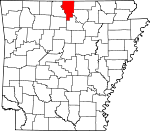
Baxter County, Arkansas Basics:


Baxter County Arkansas - Government Site

Population: 41,055
Area: 554 square miles
County seat: Mountain Home
Area code(s) in use: 870
Time zone: CST
High school graduate or higher: 86.8%
Bachelor's degree or higher: 15.5%
Median household income: $35,209
Persons in poverty: 17.2%
Home ownership rate: 77.3%
Mean travel time to work: 16.8 minutes


Adjacent counties:
Fulton  Howell (MO)  Izard  Marion  Ozark (MO)  Searcy  Stone  

Find in Arkansas

Map of the Baxter County area


Our detail map of Baxter County shows the Baxter County, Arkansas boundary lines and other interesting items.

Places in Baxter County, Arkansas

  Airports     show all on map

Baxter County Regional Hospital Heliport, Gastons Airport, Lahar Field, Ozark Regional Airport, The Bluffs Airport, The Valley Airport

  Bays     show all on map

Howard Cove

  Bridges     show all on map

Cotter Bridge, North Fork Bridge

  Buildings     show all on map

101 Gamaliel Volunteer Fire Protection District, Action Emergency Medical Services, Air - Evacuation Lifeteam 12 - Mountain Home, Baxter County Courthouse, Baxter County Sheriff's Office, Big Flat Volunteer Fire Department, Buford Volunteer Fire Department, Clarkridge Volunteer Fire Department Station 1, Clarkridge Volunteer Fire Department Station 2 Primary Station, Clarkridge Volunteer Fire Department Station 3, Clarkridge Volunteer Fire Department Station 4, Cotter - Gassville Rural Volunteer Fire District Station 2, Cotter Police Department, Cotter Volunteer Fire Department, Gassville Police Department, Gassville Volunteer Fire Department, Grover Township Volunteer Fire Department, Hand Cove Volunteer Fire Department, Henderson Volunteer Fire Department, Lakeview Police Department, Lone Rock Volunteer Fire Department, Midway Fire Protection District Fire Department, Midway Fire Protection District Volunteer Fire Department Station 2, Mountain Home City Hall, Mountain Home Fire Department Station 1, Mountain Home Fire Department Station 2, Mountain Home Police Department, Norfork Volunteer Fire Station 1, Norfork Volunteer Fire Station 2, Northeast Lakeside Volunteer Fire Department, Rodney Volunteer Fire Department Station 1, Rodney Volunteer Fire Department Station 2, Salesville Volunteer Fire Department, Tracy Area Volunteer Fire Department, United States Fish and Wildlife Norfolk National Fish Hatchery Park Security

  Capes     show all on map

Bidwell Point, Mallard Point, Teal Point

  Cemeteries     show all on map

Acklin Cemetery, Amos Cemetery, Arkana Cemetery, Athens Cemetery, Baker Cemetery, Baxter Memorial Gardens, Bentley Ridge Cemetery, Big Flat Cemetery, Burnt School House Cemetery, Casteel Cemetery, Conley Cemetery, Coots Cemetery, Cotter Cemetery, County Line Cemetery, Cuff Cemetery, Custer-Herron Cemetery, Douglas Cemetery, East Oakland Cemetery, Fairview Cemetery, Fluty Cemetery, Galatia Cemetery, Gamaliel Cemetery, Gassville Cemetery, Hand Cemetery, Haskell Cemetery, Heart Cemetery, Katy Cemetery, Lone Rock Cemetery, Martin Springs Cemetery, Maynard Cemetery, Moody Cemetery, Mountain Home Cemetery, Nelson Cemetery, Norfork Cemetery, Oak Grove Cemetery, Oakland Cemetery, Old Oakland Cemetery, Pilgrims Rest Cemetery, Quality Ridge Cemetery, Table Rock Cemetery, Thacker Cemetery, Three Brothers Cemetery, Tucker Cemetery, Walker Cemetery, Wesley Chapel Cemetery, Whiteville Cemetery

  Census     show all on map

Midway Census Designated Place

  Channels     show all on map

Trammels Shute

  Churches     show all on map

Arkana Baptist Church, Assembly of God Church, Bethel Springs Church, Bible Study Chapel, Church of Christ, Community Church, East Cotter Church, East Oakland Baptist Church, East Side Baptist Church, Fairview United Methodist Church, Fellowship Cumberland Presbyterian Church, First Baptist Church, First Christian Church, First Church of Christ Scientist, First United Methodist Church, Galatia Church, Glacia Church, Hall Chapel, Hopewell Baptist Church, Lake Norfork Church, Liberty Church of Christ, Lone Rock Baptist Church, Memorial Christian Church, Midway Baptist Church, Mount Zion Church, Mountain Home Methodist Church (historical), Mountain View Church, Oak Grove Church, One Hundred One Church, Pilgrims Rest Missionary Baptist Church, Pleasant Flat Church, Quality Ridge Church, Redeemer Lutheran Church, Reorganized Church of Jesus Christ of Latter Day Saints, Saint Andrews Episcopal Church, Saint Peters Catholic Church, Table Rock Church, Three Brothers Church, Wates Church, Wesley Chapel Methodist Church, West Side Missionary Baptist Church, Whiteville Baptist Church, Zion Church

  Cliffs     show all on map

Bean Bluff, Lone Rock, Red Bluff, White Bluff, White Bluff

  Crossings     show all on map

Biems Ford (historical), Collis Ferry (historical), Conley Ford (historical), Denton Ferry (historical), Granfiled Ferry (historical), Nelsons Ferry (historical), Souths Ferry (historical), Traceys Ferry (historical), Traceys Ford (historical), Whites Ferry (historical)

  Dams     show all on map

Big Flat Lake Dam, Gardner Lake Dam, Higginbottom Lake Dam, Norfork Dam, Ozark Acres Lake Dam

  Flats     show all on map

Trimble Flat

  Gaps     show all on map

Caroline Gap

  Hospitals     show all on map

Baxter Regional Medical Center

  Islands     show all on map

Bayless Island

  Locales     show all on map

Arkana Station, Buford Station, Buzzard Roost Landing, College Plaza Shopping Center, Cranfield Landing, Gamaliel Landing, Hand Landing, Jordan Landing, Martins Ferry, Matney Campground, Mooneys Landing, Mouth of Bruce Creek Landing, Nelson Ferry, Newton Landing, Norfork Landing, Norfork National Fish Hatchery, Ozark Center Shopping Center, Quarry Landing, Red Bank Landing, Robinson Point Landing, Salem Landing, Shipps Ferry, Shipps Landing, Starlite Drive-In (historical), Talbert Landing, Traceys Landing, Village Mall Shopping Center

  Parks     show all on map

Bidwell Point Use Area, Bull Shoals State Park, Buzzard Roose Use Area, Cranfield Use Area, Gamaliel Use Area, Georges Cove Public Use Area, Hand Use Area, Henderson Use Area, Howard Cove Use Area, Jordan Use Area, Lakeview Public Use Area, Panther Bay Public Use Area, Pigeon Creek Public Use Area, Quarry Use Area, Red Bank Use Area, Robinson Point Use Area, Seward Point Public Use Area, Talbert Use Area, Tracy Use Area, Wood Point Use Area

  Populated Places     show all on map

Advance, Amos, Arkana, Arkawana, Bennetts (historical), Berry (historical), Big Flat, Briarcliff, Buffalo City, Buford, Cartney, Casteel (historical), Chastain (historical), Clarkridge, Colfax, Conville (historical), Cotter, Covey (historical), Culp, Cumi, Custer (historical), Diamond Bay, Dogwood Park, Fawn Park, Gamaliel, Gassville, Hand (historical), Henderson, Heritage Estates, Herron, Holiday Hills, Hopewell, Independence (historical), Jonesdale (historical), Jordan, Kingswood Estates, Lakeside Terrace, Lakeview, Laytonville (historical), Lone Rock, Mallard Point, McPhearson, Midway, Monkey Run, Mountain Home, Norfork, Norfork Lake Estates, Norfork Village, Old Joe, Rodney, Salesville, Shady Grove, Shipp, Spencer (historical), Spring Lake Estates, Sycamore Heights, Sycamore Spring, Three Brothers, Timber Lake Manor, Wake (historical), Western Hills Subdivision, Whiteville, Woods Point Landing

  Post Offices     show all on map

Advance Post Office (historical), Buford Post Office (historical), Casteel Post Office (historical), Clarkridge Post Office, Culp Post Office (historical), Gamaliel Post Office, Jordan Post Office, Midway Post Office, Mountain Home Post Office

  Reserves     show all on map

Leatherwood Wilderness

  Reservoirs     show all on map

Big Flat Lake, Gardner Lake, Higginbottom Lake, Norfork Lake, Ozark Acres Lake

  Ridges     show all on map

Goat Ridge, Promise Land Ridge, Sandy Ridge

  Schools     show all on map

Amanda Gist Elementary School, Amos School (historical), Arkana School (historical), Arrie Goforth Elementary School, Bethel Springs School, Buford School (historical), Cotter High School, Gamaliel School (historical), Guy Berry Intermediate School, Hand School (historical), McPhearson School (historical), Mountain Home Baptist College (historical), Mountain Home College (historical), Mountain Home High School, Mountain Home Junior High School, Mountain Home Kindergarten School, Mountain Home Male and Female Academy (historical), Nelson-Wilks-Herron Elementary School, Norfork High School, Oakland School (historical), Pinkston Middle School, Quality Ridge School (historical), Shady Grove School (historical), Three Brothers School (historical), Tri-County High School, Wesley Chapel School (historical), Whiteville School (historical)

  Springs     show all on map

Coldwater Spring, Dew Spring, Farris Spring, Tassel Spring

  Streams     show all on map

Barren Creek, Barren Creek, Barren Fork, Bear Pen Creek, Bee Branch, Bennetts Bayou, Bennetts River, Big Creek, Briar Creek, Bruce Creek, Canes Fork, Cap Fork, Carney Creek, Cataract Creek, Cedar Creek, Cockran Creek, Coldwater Creek, Cole Fork, Cunningham Creek, Diamond Creek, Dodd Creek, Dry Creek, Dry Creek, East Pigeon Creek, Fall Creek, Farris Creek, Float Creek, Flower Creek, Fords Branch, Goose Creek, Herrons Creek, Hicks Creek, Hightower Creek, Howard Creek, Hutch Creek, Jenkins Branch, Jenkins Creek, Keeter Creek, Leatherwood Creek, Lithia Creek, Little Creek, Little Pigeon Creek, Middle Fork Moccasin Creek, Mill Creek, Monkey Run Creek, Morton Creek, Nelson Creek, North Fork River, North Prong Middle Creek, Otter Creek, Panther Creek, Panther Fork, Perry Creek, Pigeon Creek, Pine Creek, Shoal Creek, Sneeds Creek, Spring Creek, Stewart Creek, Stewart Fork, Tanner Creek, Terrapin Creek, Twin Creek, Vickory Creek, Walker Branch, Walker Creek, Walker Creek, West Fork Moccasin Creek

  Summits     show all on map

Bald Dave, Birdsong Mountain, Capitol Hill, Fletcher Mountain, Flint Knob, Heart Bald, Hickman Knob, Hip Mountain, Hixon Mountain, Horseshoe Mountain, Lee Mountain, Matney Knob, Monkey Run Hill, Naked Joe Knob, Negro Knob, Old Lonon Mountain, Perry Knob, Pretty Hill, Push Mountain, Shipps Mountain, Short Hollow Mountain, Three Brothers, Turkey Knob, Turkey Knob, Wallace Knob, Wild Hog Mountain, Wolf Knob

  Towers     show all on map

KCMH-FM (Mountain Home), KPFM-FM (Mountain Home), KTLO-AM (Mountain Home), KTLO-FM (Mountain Home), Matney Knob Lookout Tower, Push Mountain Lookout Tower

  Valleys     show all on map

Birch Minick Hollow, Birmingham Hollow, Bridge Hollow, Camp Spring Hollow, Clifty Canyon, Crib Hollow, Ellen Cockran Hollow, Fulton Hollow, Gather Hollow, Goodall Hollow, Grassy Hollow, Havener Hollow, Holsey Hollow, Hopewell Hollow, Martin Spring Hollow, Murry Treat Hollow, Powell Hollow, Rose Hollow, Rough Hollow, Salt Ground Hollow, Schinette Hollow, Shipp Hollow, Smith Hollow, Spencer Hollow, Steep Gully, Stone Hollow, Sugar Hollow, Sycamore Hollow, Trimble Hollow, Walker Hollow,

Baxter County, Arkansas Population By Race (2012 estimate)

RacePopulation
WhiteBaxter County White population 39,86439,864  
MixedBaxter County Mixed population 575574
American IndianBaxter County American Indian population 287287
AsianBaxter County Asian population 205205
BlackBaxter County Black population 8282
Hawaiian & Pacific IslanderBaxter County Hawaiian & Pacific Islander population 00

Additional population tables :
State population table
Arkansas population by county