Calhoun County, Arkansas Basics:


Calhoun County Arkansas - Government Site

Population: 5,317
Area: 629 square miles
County seat: Hampton
Area code(s) in use: 870
Time zone: CST
High school graduate or higher: 78.9%
Bachelor's degree or higher: 6.8%
Median household income: $31,425
Persons in poverty: 10.5%
Home ownership rate: 80.2%
Mean travel time to work: 25.5 minutes
Adjacent counties:
Bradley  Cleveland  Dallas  Ouachita  Union  

Find in Arkansas

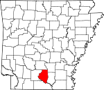
Map of the Calhoun County area


Our detail map of Calhoun County shows the Calhoun County, Arkansas boundary lines and other interesting items.

Places in Calhoun County, Arkansas

  Airports     show all on map

Hampton Municipal Airport

  Bars     show all on map

Blue Beach Shoals, Cape Horn Shoals, Cold Bite Shoal, El Dorado Shoals, English Bee Shoal, Haidee Shoals, Hog Eye Shoal, Little Buffalo Shoals, Newport Shoals, Slim Island Shoal, Smackover Shoals, Spoon Camp Shoals

  Bends     show all on map

Crooked Slough Bend, Grapevine Bend, Haynes Bend, Salt Spring Bend

  Buildings     show all on map

Calhoun County Ambulance, Calhoun County Courthouse, Calhoun County Sheriff's Office, Caney Creek Volunteer Fire Department, Chambersville Fire Department, Hampton Fire Station, Hampton Police Department, Harrell Volunteer Fire Department, Locust Bayou Fire Department, Ouachita County Ambulance Highland Basic Life Support, Southern Arkansas University Tech Police Department, Thornton Fire Station, Tinsman Fire Station

  Cemeteries     show all on map

Calaway Cemetery, Clemons Cemetery, Double Springs Cemetery, Dunn Cemetery, Earnest Cemetery, Evans Cemetery, Faustina Cemetery, Friendship Cemetery, Furr Cemetery, Greenville Cemetery, Harlow Cemetery, Little Bay Cemetery, Macedonia Cemetery, Means Cemetery, Moses Chapel Cemetery, Mount Zion Cemetery, Newton Cemetery, Oak Grove Cemetery, Pickett Cemetery, Plunkett Cemetery, Primm Cemetery, Ricks Cemetery, Saint Paul Cemetery, Stroud Cemetery

  Census     show all on map

Unorganized Territory of Shumaker (historical)

  Churches     show all on map

Antioch Church, Antioch Church, Bluff Hill Church, Campground Church, Chambersville Church, China Grove Church, Church Number 10, Dickinson Church, Ebenezer Church, Ellisville Church, Enon Church, Faustina Church, Faustina Church, Happy Home Church, Harmony Baptist Church, Hopeville Church, Locust Bayou Church, Mount Carmel Church, Mount Olive Church, Mount Pleasant Church, New Hope Church, Pilgrim Church, Pilgrims Rest Church, Pleasant Grove Baptist Church, Pleasant Grove Church, Providence Church, Ricks Church, Saint Paul Church, Sulphur Springs Church, Trinity Chapel, Union Church, Union Grove Church

  Cliffs     show all on map

Yellow Bluff

  Crossings     show all on map

Lloyd Ford

  Dams     show all on map

Covington Pond Dam, Harrell Lake Dam, Lake Cathay Dam, Lock and Dam Number Eight, Middle Pond Dam, North Pond Dam, South Pond Dam, Tri-County Lake Dam

  Guts     show all on map

Bangs Slough, Big Slough, Birdseye Slough, Crooked Slough, Cross Current Slough, Gar Slough, John Mack Slough, King Slough, Long Lake Slough, McCain Slough

  Lakes     show all on map

Big Horseshoe Brake, Big Johnson Lake, Black Lake, Black Lake Slough, Blackwater Lakes, Cages Lake, Cobeen Brake, Cooks Lake, Crane Lake, Cross Current Brake, Ditch Lake, Duck Roost Lake, Grapevine Lake, Hades Lake, Half Moon Lake, Hollingsworth Brake, Little Bay Lake, Little Horseshoe Brake, Long Lake, Mud Lake, Signboard Brake, Snow Lake, Spoon Lake, Tom Cook Brake, Tupelo Gum Brake, Viney Brake

  Locales     show all on map

Bangs Landing, Highland Industrial Park, Moro Farm (historical)

  Military     show all on map

Shumaker Naval Ammunition Depot (historical)

  Oilfields     show all on map

Artesian Oil Field, Cross Country Slough Oil Field, Hampton Oil Field, Lloyd Creek Oil Field, Locust Bayou Oil Field, Mud Lake Oil and Gas Field

  Parks     show all on map

Ham Moses Park

  Populated Places     show all on map

Artesian, Big Hill, Chambersville, Cram, Delhi (historical), Ebenezer, Elberta (historical), Ellisville, Green Hall (historical), Hampton, Harbour (historical), Harlow, Harrell, Hopeville, Levit (historical), Lindale (historical), Little Bay, Little Bay (historical), Locust Bayou, Newport, Smead (historical), Summerville, Thornton, Tinsman, Unco, Watson, Woodberry

  Reservoirs     show all on map

Artificial Lake, Covington Pond, Harrell Lake, Lake Cathay, Little Mud Lake, Middle Pond, North Pond, Ouachita River Reservoir, South Pond

  Ridges     show all on map

Big Swamp Ridge, Gilbert Ridge, Harvin Ridge

  Schools     show all on map

Blann School, Brann School, Ebenezer School, Hampton Elementary School, Hampton High School, Saint Lena School, Southwest Technical Institute, State Fire Academy, State Police Academy

  Springs     show all on map

Cagle Spring

  Streams     show all on map

Anna Branch, Athant Branch, Beaver Pond Creek, Beech Branch, Beech Creek, Berks Branch, Blackwater Creek, Blann Creek, Buckhorn Branch, Caney Creek, Champagnolle Creek, Clear Creek, Cordell Creek, Dogwood Creek, Douglas Branch, Dry Branch, Dry Creek, Dunn Creek, Dunn Creek, Emerson Branch, Garden Branch, Gilbert Branch, Harrell Branch, Hurricane Branch, Hurricane Creek, Hurricane Creek, Jack Nutt Branch, Jacks Creek, Jim Dunn Creek, Joe Jack Creek, Jolly Creek, Jumping Branch, Lick Branch, Little Caney Creek, Little Champagnolle Creek, Little Champagnolle Creek, Lloyd Creek, Locust Bayou, Lost Creek, Marlow Branch, Mayner Branch, Merritt Creek, Peters Branch, Rocky Branch, Rough Branch, Spring Branch, Taylor Creek, Turners Creek, Watson Creek, Wolf Branch

  Summits     show all on map

Boones Mound

  Swamps     show all on map

Dead Brake, Harrell Brake, Tri-County Lake

  Towers     show all on map

Artesian Lookout Tower, Bud Hill Lookout Tower, KKOL-FM (Hampton),

Calhoun County, Arkansas Population By Race (2012 estimate)

RacePopulation
WhiteCalhoun County White population 4,0254,024  
BlackCalhoun County Black population 1,1801,180
MixedCalhoun County Mixed population 7474
American IndianCalhoun County American Indian population 2121
AsianCalhoun County Asian population 1110
Hawaiian & Pacific IslanderCalhoun County Hawaiian & Pacific Islander population 00

Additional population tables :
State population table
Arkansas population by county