Johnson County, Arkansas Basics:


Johnson County Arkansas - Government Site

Population: 25,866
Area: 660 square miles
County seat: Clarksville
Area code(s) in use: 479
Time zone: CST
High school graduate or higher: 77.4%
Bachelor's degree or higher: 15.7%
Median household income: $32,198
Persons in poverty: 19.1%
Home ownership rate: 68.4%
Mean travel time to work: 19.9 minutes
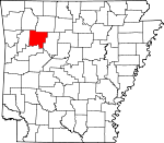
Adjacent counties:
Franklin  Logan  Madison  Newton  Pope  

Find in Arkansas

Map of the Johnson County area


Our detail map of Johnson County shows the Johnson County, Arkansas boundary lines and other interesting items.

Places in Johnson County, Arkansas

  Airports     show all on map

Clarksville Municipal Airport, Hospital Heliport, Johnson County Regional Hospital Heliport, Johnson Farm Lines Airport

  Arches     show all on map

Hurricane Creek Natural Bridge

  Buildings     show all on map

Arkansas State Police, Arkansas State Police Troop J, Clarksville Police Department, Clarksville Volunteer Fire Department, Coal Hill Police Department, Coal Hill Volunteer Fire Department, Holman-Lutherville Community Center, Johnson County Courthouse, Johnson County Rural Fire Department Station 1 Mount Vernon, Johnson County Rural Fire Department Station 1 Substation, Johnson County Rural Fire Department Station 10, Johnson County Rural Fire Department Station 11, Johnson County Rural Fire Department Station 2 Harmony, Johnson County Rural Fire Department Station 3 Substation, Johnson County Rural Fire Department Station 6, Johnson County Rural Fire Department Station 7 Lutherville, Johnson County Rural Fire Department Station 8 Hunt, Johnson County Rural Fire Department Station 9 Spadra, Johnson County Rural Fire District 2 Woodland, Johnson County Rural Fire District 3, Johnson County Rural Fire District 3, Johnson County Rural Fire District 4, Johnson County Rural Fire District 5 Flat Rock, Johnson County Sheriff's Office, Knoxville Fire Substation, Knoxville Volunteer Fire Department, Lamar Police Department, Lamar Volunteer Fire Station

  Capes     show all on map

Baxter Point, Crawford Point, Dow Point, Grassy Point, Johnson Point, Osborn Point, Shaft Point, Youngs Point

  Cemeteries     show all on map

Adams Cemetery, Adkins Cemetery, Annis Chapel Cemetery, Blakeley Cemetery, Brendle Cemetery, Brock Cemetery, Brown Cemetery, Canter Cemetery, Cazort Cemetery, Coal Hill Cemetery, Dowd Cemetery, Edwards Cemetery, Evans Cemetery, Good Hope Cemetery, Green Cemetery, Hagarville East Cemetery, Hagarville West Cemetery, Hagerville East Cemetery, Hagerville West Cemetery, Hailey Cemetery, Hardgraves Cemetery, Hardgraves Cemetery, Harmony Cemetery, Hartman Cemetery, Hess Cemetery, Hickey Cemetery, Hickey Cemetery, Hignite Cemetery, Hogan Cemetery, Holly Redeemer Cemetery, Holman Cemetery, Hon Cemetery, Huddleston Cemetery, Johnson Cemetery, Kendall Cemetery, King Cemetery, Knoxville Cemetery, Lee Cemetery, Lewis Johnson Family Cemetery, Liberty Cemetery, Love Cemetery, Macedonia Cemetery, Maddin Cemetery, McDaniel Cemetery, Miller Cemetery, Minnow Creek Cemetery, Mount Airy Memorial Cemetery, Naylor Cemetery, Newton Cemetery, Newton Cemetery, Oak Grove Cemetery, Oakland Memorial Cemetery, Ogilbie Cemetery, Ogilbie Cemetery, Old King Cemetery, Porter Cemetery, Porter Cemetery, Possum Walk Cemetery, Price Cemetery, Pryor Cemetery, Pryor Cemetery, Reynolds Cemetery, Rosetta Cemetery, Russell Cemetery, Russell Cemetery, Russell Cemetery, Saint Pauls Cemetery, Self Cemetery, Self Cemetery, Shady Grove Cemetery, Sherman Cemetery, Sherman Cemetery, Shoptaw Cemetery, Spadra Cemetery, Srygley Cemetery, Stillwell Cemetery, Treat Cemetery, Treat Cemetery, Union Cemetery, Utley Cemetery, Walton Cemetery, Watson Cemetery, West Cemetery, Wheeler Cemetery, White Oak Cemetery, Wood Cemetery, Woodland Memorial Cemetery, Woods Mountain Cemetery, Woods Mountain Cemetery, Yager Cemetery, Zachary Cemetery

  Census     show all on map

Hagarville Census Designated Place

  Churches     show all on map

Annies Chapel, Assembly of God Church, Batson Baptist Church, Bethlehem Church, Bible Church, Cabin Creek Baptist Church, Center Point Missionary Baptist Church, Church of Christ, Community Church, Community Church, Denny Church (historical), East Mount Zion Baptist Church, Faith Full Gospel Church, Ferguson Memorial Presbyterian Church, Fernwood Assembly of God Church, First Baptist Church, First Baptist Church, First Baptist Church of Hartman, First Baptist Church of Knoxville, First Freewill Baptist Church, First Presbyterian Church, Flat Rock Assembly of God Church, Free Full Gospel Church, Harmony Presbyterian Church, Hartman United Methodist Church, Hays Chapel United Methodist Church, Jamestown Assembly of God Church, Kendall Church, Lamar Baptist Church, Lees Chapel, Lees Chapel Assembly of God Church, Lone Pine Church, Maddin Chapel, Methodist Church, Miracle Temple Church, Mount Olive United Methodist Church, Mountain Home Freewill Baptist Church, Oakland Church, Oark Baptist Church, Ozone Baptist Church, Patterson Springs Church, Piney Bible Baptist Church, Pittsburgh Baptist Church, Sacred Heart Catholic Church, Second Baptist Church, Springhill Presbyterian Church, Stillwell Bible Baptist Church, Strawberry Assembly of God Church, Trinity Church, Union Grove Baptist Church, West Mount Zion Church, Whippoorwill Church (historical), Woodland Baptist Church

  Cliffs     show all on map

Bee Bluff, Burton Bluff, Feltner Bluff, Jackson Bluff, Perry Bluff, Williams Bluff

  Crossings     show all on map

Interchange 47, Interchange 55, Interchange 57, Interchange 58, Interchange 64, Interchange 67

  Dams     show all on map

Harris Pond Dam, Holloway Pond Dam, Horsehead Lake Dam, Lake Ozone Dam, Ludwig Lake Dam

  Falls     show all on map

Spainhour Falls

  Flats     show all on map

Hickory Flat, Maupin Flat

  Forests     show all on map

Ozark National Forest

  Gaps     show all on map

Grave Gap, Hignite Gap, Kings Canyon, The Narrows, Yarbough Gap

  Hospitals     show all on map

Johnson Regional Medical Center

  Islands     show all on map

Shoal Creek Island, Skaggs Island

  Lakes     show all on map

Hartman Lake

  Locales     show all on map

Buddhist Shrine, Center Point, Chronister Store (historical), Flat Rock, Flint Store, Goose Camp, Hays Chapel, Horsehead Lake Campground and Picnic Area, Johnson County Landfill, Lake Dardanelle State Fish Hatchery, Low Gap, Mount Levi, Ozone Recreation Area, Pine Crest Camp, Pine Crest Camp, Sacred Heart, Sherwood Shopping Center, University of Arkansas Experimental Farm, Wolf Pen Recreation Area

  Mines     show all on map

Utah Strip Mine

  Oilfields     show all on map

Clarksville Gas Field, Coal Hill Gas Field, Knoxville Gas Field, Linville Gas Field, Low Gap Gas Field, Ludwig Gas Field, Ozone Gas Field, Union City Gas Field

  Parks     show all on map

Cabin Creek Public Use Area, Clarksville City Park, Coal Hill City Park, Flat Rock Use Area, Haw Creek Falls Recreation Area, Horse Head Public Use Area, Horsehead Lake Recreation Area, Mineral Springs Recreation Area, Ozone Recreation Area, Piney Bay Recreation Area

  Pillars     show all on map

Pilot Rock

  Populated Places     show all on map

Batson, Bend, Bushtown (historical), Catalpa, Clarksville, Coal Hill, Dale (historical), Dillen, Edna, Farris Springs, Fort Douglas, Friley, Garber, Garrett, Gillian Settlement, Hagarville, Harmony, Hartman, Hickeytown, Hickory Flat, Hillcrest, Hinkle, Holman, Hoyt, Hunt, Jamestown, Knoxville, Knoxville Junction, Lamar, Linville (historical), Lone Pine, Ludwig, Lutherville, Martin Spring, Montana, Mount Vernon, Mount Zion, New Spadra, Oak Grove, Oark, Ozone, Piney, Poyner (historical), Rosetta, Salus, Shady Grove, Smeadley (historical), Spadra, Strawberry, Sulphur Springs, Union City, White Oak, Woodland, Yale, Zadock (historical)

  Post Offices     show all on map

Clarksville Post Office, Hagarville Post Office, Hunt Post Office, Oark Post Office, Ozone Post Office

  Ranges     show all on map

Boston Mountains, Pilot Rock Mountain, Pine Mountain

  Reservoirs     show all on map

Harris Pond, Horsehead Lake, Lake Dardanelle, Lake Ludwig, Lake Ozone

  Ridges     show all on map

Bee Ridge, Bee Ridge, Brushy Ridge, Carroll Ridge, Chalybeate Spur, Chinquapin Ridge, Grass Ridge, Horsewater Ridge, Jims Ridge, McConnell Ridge, Middle Ridge, Pine Ridge, Walnut Ridge

  Schools     show all on map

Beech Grove School, Bluff Spring School, Clarksville Adult Education Center, Clarksville Elementary School, Clarksville High School, Clarksville Junior High School, Clarksville Primary School, Gillian School, Grace James School (historical), Hurie School (historical), Kraus Middle School, Kraus School, Lamar Elementary School, Lamar High School, Lamar Middle School, Michie School, Minnow Creek School, Mount Pleasant School, Mount Pleasant School, Mount Vernon School, Mount Zion School, Mulberry Grove School, Murray Chapel School, New Life Christian School, Oak Grove School, Oark Elementary School, Oark High School, Pleasant Ridge School, Pyron Elementary School, Red Oak School, Saint Pauls Lutheran School (historical), Stillwell School, Strawberry School, Summerland School, Union School, University of the Ozarks, Westside Elementary School, Westside High School, Westside School, Woods Mountain School

  Springs     show all on map

Cazort Springs, Farris Springs

  Streams     show all on map

Basham Creek, Bear Branch, Bear Creek, Big Piney Creek, Bowen Creek, Briar Branch, Bull Creek, Burt Creek, Cabin Creek, Cedar Creek, Cedar Creek, Cole Creek, Cove Creek, Cowan Branch, Craven Branch, Curtis Creek, Deevers Branch, Deevers Branch, Devils Fork, Dicks Branch, Dirty Creek, Dry Creek, Dry Creek, Dry Creek, Dry Spadra Creek, East Fork Horsehead Creek, East Prong Minnow Creek, Estep Creek, Flat Rock Creek, Friley Creek, Gee Creek, Granny Creek, Grassy Point Creek, Grassy Point Creek, Greenbrier Creek, Haw Creek, Hogskin Creek, Hole Creek, Horsehead Creek, Hurricane Creek, Lewis Prong, Lick Branch, Lick Creek, Liddy Creek, Little Cow Creek, Little Granny Creek, Little Minnow Creek, Little Mulberry Creek, Little Piney Creek, Little Spadra Creek, Little Sulphur Creek, Little Willett Branch, Long Creek, Middle Cow Creek, Mikes Creek, Mikles Creek, Minnow Creek, Murray Creek, Opossum Branch, Owens Creek, Panther Creek, Patsy Creek, Pea Prong Creek, Peters Branch, Rock Creek, Slough Creek, Spadra Branch, Spadra Creek, Spring Creek, Spring Slough, Sugar Creek, Sulphur Creek, Toms Branch, Trace Creek, Washita Creek, West Fork Horsehead Creek, Wolf Pen Creek

  Summits     show all on map

Bald Knob, Bluebaugh Hill, Brown Mountain, Brown Mountain, Clubb Hill, Colony Mountain, Devils Knob, Garlands Knob, Grassy Point, Hagarville Mountain, Hagerville Mountain, Hess Knob, Katie Knob, Lutherville Mountain, Mac Wood Mountain, McCracken Hills, Meadows Knob, Napoleon Knob, Ozone Mountain, Pilot Knob, Pilot Rock Mountain, Pine Mountain, Red Lick Mountain, Rich Knob, Round Mountain, Saul Mountain, Stillwell Mountain, Tackey Hill, Tater Hill, Tater Hill, Thompson Knob, Thompson Mountain, Tick Hill, Turkey Hill, Turkey Mountain, Wheeler Knob, Woods Mountain

  Towers     show all on map

Devils Knob Lookout Tower, KGMR Radio Tower, KGMR-FM (Clarksville), KLYR Radio Tower, KLYR-AM (Clarksville), KLYR-FM (Clarksville), KXIO-FM (Clarksville)

  Trails     show all on map

Grassy Point Trail, Ozark Highlands Trail, Peggy Steep Trail

  Valleys     show all on map

Acord Hollow, Blackard Hollow, Bowman Hollow, Butts Hollow, Childers Hollow, Clifty Hollow, Coon Hollow, Devil Jump Hollow, Dow Hollow, Dry Hollow, Eldrige Hollow, Graveyard Hollow, Hignite Hollow, Lock Hollow, Looper Hollow, Morgan Hollow, Officers Hollow, Owens Hollow, Owens Hollow, Pullman Hollow, Sally Ann Hollow, Sally Ann Hollow, Sarah Hollow, Short Hollow, Short Hollow, Short Hollow, Turkey Hollow, Wolf Pen Hollow,

Johnson County, Arkansas Population By Race (2012 estimate)

RacePopulation
WhiteJohnson County White population 24,36624,365  
BlackJohnson County Black population 491491
MixedJohnson County Mixed population 414413
American IndianJohnson County American Indian population 336336
AsianJohnson County Asian population 233232
Hawaiian & Pacific IslanderJohnson County Hawaiian & Pacific Islander population 2625

Additional population tables :
State population table
Arkansas population by county