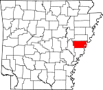
Lee County, Arkansas Basics:
Lee County Arkansas - Government Site
Population: 10,200
Area: 603 square miles
County seat: Marianna
Area code(s) in use: 870
Time zone: CST
High school graduate or higher: 70.8%
Bachelor's degree or higher: 6.4%
Median household income: $26,098
Persons in poverty: 30.9%
Home ownership rate: 60.7%
Mean travel time to work: 20.8 minutes
Adjacent counties:
Crittenden Monroe Phillips St. Francis Tunica (MS)
Places in Lee County, Arkansas
Dawson's Airport,
Frost Flying Inc Airport,
Gerrard Airport,
Lee Memorial Hospital Heliport,
Marianna/Lee County Airport-Steve Edwards Field Ashley Point,
Blue Point,
Diamond Woods Basket Bar,
Campbell Bar,
Cow Bayou Bar,
Egg Bar,
Ground Lump Bar,
True Love Bar,
Walling Bar Casteel Hollow,
Ebos Hollow,
Ripper Hollow,
Swede Hollow,
Taylor Pasture,
Whiteside Hollow Blendsoe Bend,
Browns Bend,
Commerce Cut Off,
Double Bar Bend,
Egg Bar Bend,
Grants Bend,
Hale Bend,
High Bank Bend,
Jeffersonville Bend,
Mhoon Bend,
OK Bend,
Sandy Bayou Bend,
Short Bend Air - Evacuation Lifeteam 42,
Arkansas Department of Corrections East Arkansas Regional Unit,
Aubrey Rural Volunteer Fire Station,
Gill Community Center (historical),
Haynes Rural Volunteer Fire Department,
Lee County Courthouse,
Lee County Sheriff's Office,
Lee County Volunteer Fire Department,
Marianna City Hall,
Marianna Police Department,
Marianna Volunteer Fire Department,
Moro Fire Department,
Pafford Emergency Medical Services,
Rondo Fire Station Piney Fork Ditch,
Saint Francis Floodway Ball Point,
Beaver Point,
Beech Point,
Blue Point (historical),
Eagle Point,
Hale Point,
Hardin Point,
Willow Point Andrews Cemetery,
Antioch Cemetery,
Bethlehem Cemetery,
Casteel Cemetery,
Clay Hill Cemetery,
Dansby Cemetery,
Garrett Cemetery,
Gassett Cemetery,
Gill Cemetery,
Greater Jerusalem Cemetery,
Hawkins Chapel Cemetery,
Haynie Cemetery,
Higgins Cemetery,
Holland Cemetery,
Hopewell Cemetery,
Jackson Cemetery,
Jeffersonville Cemetery,
Jersalem Cemetery,
Johnson Cemetery,
Lackie Cemetery,
Lagrange Cemetery,
Long Cane Cemetery,
Marianna Memorial Park Cemetery,
Mars Hill Cemetery,
Mars Hill Church,
Martin Cemetery,
Morning Star Cemetery,
Moro Cemetery,
Mound Cemetery,
Mound City Cemetery,
Mount Moriah Cemetery,
Mount Zion Cemetery,
New Hope Cemetery,
Paradise Cemetery,
Peters Cemetery,
Pilgrim Cemetery,
Possum Trot Cemetery,
Prospect Cemetery,
Saint Marks Cemetery,
Saint Marks Cemetery,
Saint Marys Cemetery,
Saint Paul Cemetery,
Shady Grove Cemetery,
Shepherd Grove Cemetery,
Soudan Cemetery,
Spring Creek Cemetery,
Spring Lake Cemetery,
Taylor Cemetery,
Terrell Cemetery,
Thompson Cemetery,
Trinity Cemetery,
Ward Farm Cemetery Hardin Cut-Off,
Madison-Marianna Diversion Antioch Church (historical),
Bald Point Church (historical),
Bethlehem Baptist Church,
Bethlehem Church,
Brickeys Community Baptist Church,
Brush Arbor Church (historical),
Calvary Church,
Church of God,
Community Church,
First Christian,
First Friendship Baptist Church,
First United Methodist Church of Marianna,
First United Pentecostal Church,
Freedonia Church,
Gospel Temple,
Greater Jerusalem Church,
Happy Church,
Haven Chapel,
Hawkins Chapel,
Holly Grove Church,
Holly Grove Church,
Jeffersonville Church,
Jerusalem Church,
Lee Chapel (historical),
Lee County Church,
Marianna Church of Christ,
Marianna First Baptist Church,
Marianna Missionary Baptist Church,
Marianna Second Baptist Church,
Morning Star Church,
Moro Temple,
Mound City Church,
Mount Canaan Church,
Mount Gallard Church,
Mount Jerdan Church (historical),
Mount Moriah Baptist Church,
Mount Olive Church,
Mount Olive Church (historical),
Mount Sinai Church,
Mount Zion Church,
Mount Zion Church,
Mount Zion Church,
Mount Zion Church (historical),
New Bethel Church,
New Hope Church,
New Hope Church (historical),
New Hope Missionary Baptist Church,
New Life Church,
New Mount Olive Church (historical), Old Liberty Church (historical),
Paradise Church,
Paradise Missionary Baptist Church,
Peters Church,
Peters Rock Church,
Peters Rock Church (historical),
Pettys Chapel Baptist Church,
Pilgrim Church,
Pleasant Valley Missionary Baptist Church,
Ragland Memorial Presbyterian Church,
Saint Andrews Catholic Church,
Saint Holmes Church,
Saint Johns Church,
Saint Johns Missionary Baptist Church,
Saint Luke African Methodist Episcopal Church,
Saint Marks Church,
Saint Paul Church,
Salem Methodist Church,
Scott Valley Church (historical),
Scruggs Chapel,
Sequell Church,
Shady Grove Church,
Shady Grove Church,
Shepherd Grove Missionary Baptist Church,
Spring Grove Church,
Spring Lake Church,
Springfield Church,
Taylor Chapel,
Third Zion Church,
Trinity Church (historical),
Union Church,
Union Liberty Missionary Baptist Church,
Walls Chapel Baptist Church Phillips Bayou Ferry (historical),
Red Oak Ferry (historical),
True Love Crossing Bear Creek Lake Dam,
Crystal Lake Dam,
Huxtable Dam Warrior Bottom Saint Francis National Forest Cow Bayou,
Frenchman Bayou,
Kate Adams Chute,
Otter Slough,
Phillips Bayou,
Sandy Bayou,
Three Mile Slough Lee County Memorial Hospital Island Number 58,
Peters Island Anderson Lake,
Bain Lake,
Big Twin Lake,
Big Yancopin Lake,
Blue Hole,
Blue Lake,
Box Lake,
Brushy Lake,
Cannon Lake,
Cannon Lake,
Dry Lake,
Ellison Lake,
Goose Lake,
Johnson Lake,
L'Anguille Lake,
Laddie Lake,
Larkin Lake,
Little Mossy Lake,
Little Twin Lake,
Little Yancopin Lake,
Long Lake,
Long Lake,
Long Lake,
McCloud Lake,
McNulty Lake,
Midway Lake,
Millseed Lake,
Mossy Lake,
Piney Fork Lake,
Round Pond,
Rowing Lake,
Shenship Lake,
Walnut Lake,
Whistling Lake Basket Bar Dikes,
Below Walnut Bend Dikes,
Peters Revetment,
Walnut Bend Revet Ashley Point Lodge,
Baynes Spur,
Bear Creek Lake Recreation Site,
Bemis Plantation,
Blue Point Landing,
Clay Hill,
Corner Place,
Deer Lake Farm,
Frost Fish Farm,
Grants Landing,
Hardin Point Lodge,
High Banks Landing,
Lady Lee-Campbell Landing,
Lone Pine Campground,
Maple Flat Campground,
Marianna Country Club,
Marianna Industrial Park,
McDaniels Farm,
Mound Place Landing,
Osborn Landing,
Peters Landing,
Plaza Shopping Center,
Poinsett Spur,
Saint Francis Island Lodge,
Smith Lodge,
Soudan Landing,
Spencer Place,
Tate Landing,
Tate Lodge,
University of Arkansas Cotton Branch Experiment Station Atkins Park,
Beginning Point of the Louisiana Purchase Survey,
Court Square Askew (historical),
Aubrey,
Beck,
Big Creek Corner,
Bledsoe,
Brickeys,
Canaan,
Chappelle (historical),
Cody,
Council,
Cypress Corner,
Dansby,
Felton,
Four Forks,
Garrett Grove,
Gassett,
Gill,
Greer Place,
Haleside,
Haynes,
Holub Crossing,
Hopper,
Jeffersonville,
Kincade Bayou (historical),
Kokomo,
La Grange,
Little Prairie (historical), Lone Pine (historical),
Marianna,
Midway,
Moro,
Nash Corner,
New Hope,
New Salem,
Oak Forest,
Oakwood,
Park Place,
Peters,
Phillips Bayou,
Raggio,
Reese,
Rondo,
Scott Valley,
Smith Corner,
Soudan,
South Plains,
Spencer Place,
Spring Creek,
Thomasville,
Tongin,
Vanness Crossing,
Vineyard,
Westor,
Whitehall,
Winona,
Wrightland Aubrey Post Office,
Brickeys Post Office, Felton Post Office (historical), Gill Post Office (historical), Haynes Post Office, Jeffersonville Post Office (historical),
La Grange Post Office,
Marianna Post Office, Moro Post Office, Park Place Post Office (historical), Phillips Bayou Post Office (historical), Rough and Ready Post Office (historical), Walnut Ridge Post Office (historical)
Bear Creek Lake,
Crystal Lake Crowley Ridge,
Skidmore Ridge Anna Strong Elementary School,
Anna Strong Middle School,
Antioch School (historical),
Aubrey School (historical),
Bald Point School (historical), Ball Point School (historical),
Bowman School,
Brickeys School (historical), Brooks School (historical),
Carver School,
Cody School (historical),
Council School (historical),
Cut-off School (historical),
Danford School (historical),
Dansby School (historical),
Double Bend Bar School (historical),
Eastwood School (historical),
Fairview School (historical), Felton School (historical),
Gill School,
Gill School, Harris School (historical),
Haynes School (historical),
Jeffersonville School (historical), La Grange School (historical),
Lee Academy,
Lee County Training School (historical),
Lee High School,
Marianna High School (historical), Marianna Male and Female Institute (historical), Mars Hill School (historical),
Moro Elementary School,
Mound School (historical),
Mount Moriah School (historical), Mulberry School (historical),
Nash Ridge School (historical),
Newsom School (historical),
Nunnally Elementary School,
Oak Forest School (historical), Oak Grove School (historical), Oak Hall School (historical), Paragon School (historical),
Peters Rock School (historical),
Phillips Bayou School (historical),
Pilgrim School (historical), Pine Fork School (historical),
Pine Ridge School (historical),
Pleasant Valley School (historical),
Rondo School (historical), Rosenwald School (historical),
Rosenwald School (historical),
Saint Austin School,
Saint Johns School (historical),
Saint Marys Missionary Church School,
Saint Marys School (historical),
Salem School (historical),
Scott Valley School (historical),
Shepherd Grove School (historical),
Skidmore School (historical),
Soudan School (historical),
South Plains School (historical),
Spring Grove School,
Tongin School (historical), Trinity School (historical),
Union Liberty School (historical),
Union School (historical),
Walls School,
Westor School (historical),
Westwood School (historical),
White Wall School (historical),
Whitehall School (historical),
Whitehall School (historical),
Whitten Elementary School,
Willow School (historical), Yarbrough School (historical)
Alligator Bayou,
Bear Creek,
Big Cypress Creek,
Big Piney Creek,
Cat Creek,
Cow Bayou,
Eight Mile Reach,
Flat Fork Creek,
Hawkins Creek,
Holcomb Bayou,
L'Anguille River,
Larkin Creek,
Little Hog Tusk Creek,
Little Piney Creek,
Mossy Lake Bayou,
North Alligator Bayou,
Patterson Creek,
Piney Creek,
Raft Bayou,
Sandy Slough,
South Alligator Bayou,
Spring Creek,
Sugar Creek,
West Fork Bear Creek Morrells Hill,
Robinson Hill Horse Head Lake,
Old River,
Shenship Lake Horn Lookout Tower,
KBFC-FM (Forrest City),
KVNZ-FM (Marianna),
KZOT-AM (Marianna) Horn Hollow,
Whitehall Crevasse,

