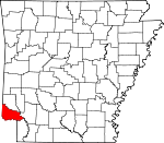
Little River County, Arkansas Basics:
Little River County Arkansas - Government Site
Population: 12,920
Area: 532 square miles
County seat: Ashdown
Area code(s) in use: 870
Time zone: CST
High school graduate or higher: 84.1%
Bachelor's degree or higher: 10.9%
Median household income: $39,042
Persons in poverty: 14.9%
Home ownership rate: 80.3%
Mean travel time to work: 24.9 minutes
Adjacent counties:
Bowie (TX) Hempstead Howard McCurtain (OK) Miller Sevier
Places in Little River County, Arkansas
Pine Prairie Airport Index Bridge,
Little River Bridge 9th West Judicial District Drug Task Force,
Alleene Fire Department,
Arden Volunteer Fire Department,
Ashdown Fire Department Station 1,
Ashdown Fire Department Station 2,
Ashdown Library,
Ashdown Police Department,
Cerro Gordo Volunteer Fire Department,
Domtar Industries Ashdown Mill Ambulance Services,
Domtar Industries Fire Department Ashdown Mill,
East Ogden Volunteer Fire Department,
East Ogden Volunteer Fire Department,
Foreman Marshall's Office,
Foreman Volunteer Fire Department,
Hicks Volunteer Fire Department,
Jacks Isle Volunteer Fire Station,
Lifenet, Incorporated - Ashdown (Ambulance Services),
Little River County Courthouse,
Little River County Jail,
Little River Nursing Home,
Little River Sheriff's Office,
Oakhill Volunteer Fire Department,
Ogden Volunteer Fire Department,
Pleasant Manor Nursing Home,
Richmond Volunteer Fire Department,
Wallace Volunteer Fire Department,
Wilton Volunteer Fire Station,
Winthrop Fire Department,
Yarborough Fire Department Station 1,
Yarborough Fire Department Station 2 Alleene Cemetery,
Arden Cemetery,
Ashdown Cemetery,
Blackland Cemetery,
Bradshaw Cemetery,
Camp Grounds Cemetery,
Catholic Cemetery,
Cerrogordo Cemetery,
Cook Cemetery,
Cooper Cemetery,
Dollarhide Cemetery,
Dowden Cemetery,
Freeman Cemetery,
French Cemetery,
French Cemetery,
Gravelly Cemetery,
Green Cemetery,
Hawkins Cemetery,
Hemphill Cemetery,
Hicks Cemetery,
Hopson Cemetery,
Mills Cemetery,
New Home Cemetery,
Newsom Cemetery,
Oak Hill Cemetery,
Pauley Cemetery,
Peytonville Cemetery,
Pine Grove Cemetery,
Piney Cemetery,
Red Oak Grove Cemetery,
Rhodes Cemetery,
Richmond Cemetery,
Saint Lukes Cemetery,
Spring Hill Cemetery,
Strawn Cemetery,
Wilton Cemetery Yarborough Landing Census Designated Place Alleene Baptist Church,
Bethel Missionary Baptist Church,
Blackland Church,
Bright Star Baptist Church,
Cedar Springs Baptist Church,
Central Baptist Church,
Church of Christ,
Craig Chapel African Methodist Episcopal Church,
Elizabeth Baptist Church,
Elmore Church,
First Assembly of God Church,
First Baptist Church,
First Baptist Church of Ogden,
First Christian Church,
First Church of the Nazarene,
First Presbyterian Church,
First United Methodist Church,
French Church,
Friendship Church,
Gravelly Church,
Greater Mount Zion Baptist Church,
Haney Creek Baptist Church,
Hicks First Baptist Church,
Holy Cross Church,
Hopewell Baptist Church,
House of God Church,
King Ryder Church of Christ,
Mount Moriah Church,
New Hope Church,
Oak Grove Baptist Church,
Oak Hill Cumberland Presbyterian Church,
Peytonville Cumberland Presbyterian Church,
Red Oak Baptist Church,
Richmond United Methodist Church,
Royal Chapel,
Saint John Church,
Saint Luke Baptist Church,
Saint Matthews Baptist Church,
Saint Paul Church,
Saint Rest Missionary Baptist Church,
State Line Baptist Church,
Turner Church,
Wades Chapel United Methodist Church,
Walnut Grove Church,
Zealia Chapel Red Bluff,
Shepherd Bluff Dunbar Lake Dam,
Haney Creek Watershed Site Two Dam,
Harris Lake Dam,
M C Jones Lake Number One Dam,
M C Jones Lake Number Two Dam,
Millwood Country Club Lake Dam,
Millwood Dam,
Nacoosa Paper Retention Pond Levee,
Pullen Lake Dam,
Pyron Lake Dam,
Sivley Lake Dam,
SW Arkansas W D Holding Basin Dam Gum Flats Big Slough,
Hickory Slough Ashdown Hospital (historical),
Little River Memorial Hospital Gano Island,
Jack Island Applewhite Cut-off Lake,
Bear Lake,
Boggy Slough,
Choctaw Bayou,
Cut-off Lake,
Cut-off Lake,
Dunn Lake,
First Lake,
Fish Lake,
Grassy Lake,
Hamilton Lake,
Hudson Lake,
Hurricane Bend Lake,
LaVoice Lake,
Mill Lake,
Muddy Lake,
Old River Lake,
Old River Lake,
Old River Lake,
Pleasant Lake,
Red Lake,
Red Lake,
Roseborough Lake,
Scott Lake,
Trailer Lake,
Trout Lake,
Young Lake Hoods Landing (historical),
Little River Country Club,
Matteson Gin,
Moore Camp,
Oak Hill,
Southtown Shopping Center,
Taylors Store,
Ward Ferry,
White Cliffs Station Ashdown City Park,
Cypress Slough Public Use Area,
Millwood State Park,
Patterson Shoals Public Use Area,
Peyton Public Use Area,
River Run West Public Use Area,
White Cliffs Public Use Area,
Wilton Landing Public Use Area Alleene,
Arden,
Arkinda,
Ashdown,
Billingsleys Corner,
Cerrogordo,
Cole,
Comet,
Cross Roads,
Eastport,
Fomby,
Foreman,
Hicks,
Jacks Isle,
Jewell,
Lanesport,
Leidygate (historical),
Lippton (historical),
Long,
Millwood,
Mistletoe (historical),
Morris Ferry (historical),
Oak Grove,
Oak Grove,
Ogden,
Orton,
Pankov,
Peytonville,
Pine Prairie,
Rankin (historical),
Red Bluff,
Richmond,
Rocky Comfort,
Temple,
Thompson Subdivision,
Wades Chapel,
Wallace,
Wilton,
Winthrop,
Yarborough Landing Alleene Post Office, Arden Post Office (historical), Arkinda Post Office (historical),
Ashdown Post Office, Bishop Post Office (historical), Bivens Post Office (historical), Cerrogordo Post Office (historical), Coleboro Post Office (historical), Critten Ridge Post Office (historical), Foreman Post Office, Hudson Post Office (historical), Jewel Post Office (historical), Laynesport Post Office (historical), Lippton Post Office (historical), Long Post Office (historical), Millwood Post Office (historical), Minneola Post Office (historical), Morris Ferry Post Office (historical), Ogden Post Office, Orton Post Office (historical), Peytonville Post Office (historical), Pineprairie Post Office (historical), Rankin Post Office (historical), Red Bluff Post Office (historical), Richmond Post Office (historical), Rocky Comfort Post Office (historical), Shoals Post Office (historical), Wilton Post Office, Winthrop Post Office
Country Club Lake,
Dunbar Lake,
Haney Creek Watershed Site Two Reservoir,
Harris Lake,
M C Jones Lake Number One,
Millwood Lake,
Nacoosa Paper Retention Pond,
Pullen Lake,
Pyron Lake,
Sivley Lake,
SW Arkansas W D Holding Basin,
Two Reservoir Alleene School (historical),
Arden School (historical), Arkinda School (historical),
Ashdown High School,
Ashdown Junior High School,
Ashdown Training School (historical), Bird School (historical),
Blackland School (historical), Bright Star School (historical),
Burke Street Elementary School,
C D Franks Elementary School,
C D Franks Intermediate School,
Climax School, Davis School (historical), Endora School (historical), Flat Creek School (historical),
Fomby School (historical),
Foreman Elementary School,
Foreman High School,
Foremen Elementary School, French Academy (historical),
Friendship School (historical), Glendale School (historical), Goodwin School (historical), Gravelly School (historical), Greenhorn Academy (historical), Hicks School (historical), Homestead School (historical), Hopewell School (historical), Hopson Negro School (historical), Hudson School (historical), Jones School (historical),
King Rider School,
L F Henderson Interm School, Laynesport School (historical), Lippton School (historical),
Margaret Daniels Primary School, McIntyre School (historical),
Miller School, Millwood School (historical), Mount Moriah School (historical),
Nolen School (historical),
Oak Grove School (historical), Oak Hill School (historical), Ogden High School (historical),
Oscar Hamilton Elementary School, Pauley School (historical), Peytonville School (historical), Pine Prairie School (historical),
Plainview School, Pleasant Hill School (historical), Rankin School (historical), Red Oak Grove School (historical), Richland School (historical), Richmond Male and Female Academy (historical),
Richmond School (historical), Rocky Comfort Academy (historical), Rocky Comfort High School (historical), Rocky Comfort Institute (historical),
Rosenwald School,
Royal Chapel School (historical), Saint Luke School (historical),
School Number 4 (historical), Spring Hill School (historical), Unity School (historical),
Wade Chapel School (historical), Wallace School (historical),
Washington School,
White Cliffs School,
Wilton School (historical),
Winthrop Elementary School,
Winthrop High School Allen Creek,
Beaver Creek,
Bell Branch,
Black Branch,
Blacks Branch,
Bois d'Arc Bayou,
Bull Creek,
Buster Creek,
Calton Creek,
Caney Creek,
Cooper Creek,
Crooked Slough,
Cut-Off Slough,
East Flat Creek,
Flat Creek,
French Branch,
French Creek,
Gafford Branch,
Haney Creek,
Haw Branch,
Hemphill Creek,
Horseshoe Slough,
Hudson Creek,
Hurricane Creek,
Hurricane Creek,
Lick Creek,
Line Creek,
Little River,
McKinney Creek,
Mill Branch,
Murl Branch,
North Caney Creek,
Old Channel Little River,
Peytonville Branch,
Red Branch,
South Caney Creek,
Sterling Branch,
Surratt Branch,
Walnut Bayou,
Wards Creek,
West Flat Creek,
Yellow Branch Lime Rock Hill Beaver Pond,
Brush Lake,
Brushy Lake,
Cattail Lake,
Grassy Lake,
Horseshoe Lake,
Jim Lee Lake,
The Old Sag,
Tyler Slough KARQ-FM (Ashdown),
KTFS-FM (Ashdown),

