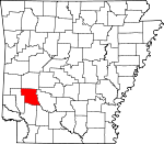
Pike County, Arkansas Basics:


Pike County Arkansas - Government Site

Population: 11,280
Area: 601 square miles
County seat: Murfreesboro
Area code(s) in use: 870
Time zone: CST
High school graduate or higher: 78.3%
Bachelor's degree or higher: 12.4%
Median household income: $32,087
Persons in poverty: 20.8%
Home ownership rate: 72.8%
Mean travel time to work: 25.0 minutes


Adjacent counties:
Clark  Hempstead  Howard  Montgomery  Nevada  Polk  

Find in Arkansas

Map of the Pike County area


Our detail map of Pike County shows the Pike County, Arkansas boundary lines and other interesting items.

Places in Pike County, Arkansas

  Airports     show all on map

Pike County Hospital Heliport

  Bays     show all on map

West Fork Lake Greeson

  Buildings     show all on map

Antoine Volunteer Fire Department, Daisy Volunteer Fire Department, Delight Ambulance Service, Delight Rural Volunteer Fire Department, Emergency Medical Transport, Emergency Medical Transport, Glenwood Fire Department, Glenwood Police Department, Kirby Volunteer Fire Station, Langley Volunteer Fire Department, Lodi Volunteer Fire Station, Murfreesboro Fire Station, Murfreesboro Police Department, Nathan Volunteer Fire Department, New Hope Fire Department, Pike County Courthouse, Pike County Sheriff's Office

  Cemeteries     show all on map

Antoine Cemetery, Bear Creek Cemetery, Bell Bluff Cemetery, Billstown Cemetery, Brocktown Cemetery, Brushy Cemetery, Coker Cemetery, College Hill Cemetery, Cummings Cemetery, Ebenezer Cemetery, Hannon Cemetery, Hicks Cemetery, Kirby Cemetery, Lamb Cemetery, Lee Cemetery, Liberty Cemetery, Macedonia Cemetery, Mount Tabor Cemetery, Murfreesboro Cemetery, Nash Cemetery, Oak Grove Cemetery, Old Ebenezer Cemetery, Palestine Cemetery, Powers Chapel Cemetery, Roy Cemetery, Shiloh Cemetery, Sparks Cemetery, Valley Grove Cemetery, Valley Grove Cemetery, Wall Creek Cemetery, White Oak Cemetery, Woodall Cemetery, Woods Cemetery

  Census     show all on map

Kirby Census Designated Place

  Churches     show all on map

Assembly of God Church, Assembly of God Church, Bethel Missionary Baptist Church, Bethlehem Missionary Baptist Church, Biggs Chapel Methodist Church, Caney Fork Church (historical), Caney Valley Missionary Baptist Church, Church of Christ, Crossroads Church, Eden Landmark Church, Fairview Baptist Church, Free Will Baptist Church, Happy Hill Church (historical), Harrison Church, Hickory Grove Church, Japany Church, Kingdom Hall, Lodi Missionary Baptist Church, Maple Springs Baptist Church, Midway Missionary Baptist Church, Mount Joy Church, Mount Moriah Missionary Baptist Church, Mount Tabor Methodist Church (historical), Mount Zion Methodist Church (historical), Muddy Fork Methodist Episcopal Church South (historical), Nathan Church of Christ, Palestine Church (historical), Pike City Missionary Baptist Church, Pine Grove Church, Pleasant Grove Church, Pleasant Grove Primitive Baptist Church, Pleasant Home Church, Powers Chapel (historical), Primitive Baptist Church, Rosboro Missionary Baptist Church (historical), Salem Baptist Church, Saline Church of Christ, Spring Hill Missionary Baptist Church, Sweet Home Church, Sweet Home Missionary Baptist Church

  Cliffs     show all on map

Bell Bluff, Hinds Bluff, Plaster Bluff, Wall Rock

  Dams     show all on map

Lake Greeson Nursery Pond Dam, Mill Pond Dam, Narrows Dam, North Fork Ozan Creek Site One Dam, North Fork Ozan Creek Site Two Dam, Teeter Lake Dam, Tetter Lake Two Dam, Womack Lake Dam

  Gaps     show all on map

Brooks Gap, Dripping Springs Gap, Lassie Gap, Motley Gap, Redland Gap

  Hospitals     show all on map

Pike County Memorial Hospital

  Lakes     show all on map

Alford Lake, Round Pond

  Locales     show all on map

Beacon Hill Picnic Area, Caddo Ranger Station and Work Center, Camp Tula, Lyons Ford, Stevensons Camp (historical), Sweet Home, Twin Bridges

  Mines     show all on map

American Mine, Arkansas Mine, Crater of Diamonds, Kimberlite Mine, Mauney Mine, Ozark Mine

  Parks     show all on map

Arrowhead Point Public Use Area, Bear Creek Public Use Area, Cowhide Cove Public Use Area, Crater of Diamonds State Park, Daisy State Park, Highway 70 Landing Public Use Area, Kirby Landing Public Use Area, Laurel Creek Public Use Area, Narrows Dam Public Use Area, Parker Creek Public Use Area, Pikeville Public Use Area, Riverside Picnic Area, Rock Creek Public Use Area, Self Creek Public Use Area, Star of the West Public Use Area, Wylie Picnic Area

  Pillars     show all on map

Chimney Rock

  Populated Places     show all on map

Abner (historical), Anderson (historical), Antoine, Arp (historical), Ball (historical), Billstown, Bowen, Brocktown (historical), Caney Valley, Cooleyville, Cooper (historical), Crawford (historical), Daisy, Delight, Dunlap (historical), Elk (historical), Glenwood, Grandfield, Helbig (historical), Henry, Highland, Hopewell (historical), Kimberley, Kirby, Langley, Lissie (historical), Lodi, Maxwell (historical), Mount Moriah, Murfreesboro, Nathan, Newhope, Norvelle (historical), Nutts, Pike City, Piney Grove, Pisgah, Pleasant Home (historical), Rabell (historical), Rock Creek (historical), Rosboro, Roy, Salem, Shawmut, Stanley (historical), Star of the West (historical), Stelltown, Stephenson (historical), Wright (historical), Zebulon (historical)

  Post Offices     show all on map

Brocktown Post Office (historical), Caney Fork Post Office (historical), Elk Post Office (historical), Kirby Post Office, Langley Post Office, Nathan Post Office (historical), Newhope Post Office, Pineland Post Office (historical), Wolf Creek Post Office (historical)

  Reservoirs     show all on map

Lake Greeson, Lake Greeson Nursery Pond, Mill Pond, North Fork Ozan Creek Watershed Number One Reservoir, North Fork Ozan Creek Wateshed Number Two Reservoir, Teeter Lake, Tetter Lake Two, Womack Lake

  Ridges     show all on map

Kirby Mountain, Reynolds Mountain, South Fork Mountains, Wall Mountain

  Schools     show all on map

Academy School (historical), Bethel School (historical), Bills School (historical), Brocktown School (historical), Centerpoint High School, Centerpoint Primary School, Delight Elementary School, Delight High School, Glenwood Elementary School, Glenwood High School, Kirby Elementary School, Kirby High School, Lodi School (historical), Miller School, Murfreesboro Elementary School, Murfreesboro High School, Pleasant Hill School, Rosewald School (historical), Shawmut School (historical)

  Springs     show all on map

Dripping Springs, Wildcat Spring

  Streams     show all on map

Allen Branch, Bacon Creek, Baldon Branch, Bandy Creek, Bear Creek, Beaver Creek, Big Branch, Bigsby Branch, Blackland Branch, Blocker Creek, Blocker Creek, Blue Creek, Brickyard Creek, Brushy Creek, Buck Branch, Buck Creek, Buffalo Creek, Camel Branch, Camp Creek, Caney Creek, Caney Creek, Caney Creek, Chinquapin Branch, Clear Creek, Coon Creek, Cowhide Creek, Cowlick Branch, Daisy Creek, Dry Branch, Dry Branch, Fallen Creek, Forrester Branch, Fox Branch, Gap Creek, Gum Creek, Hickory Creek, Hogpen Creek, Hurricane Creek, Ikes Creek, Johnson Branch, Kirkham Branch, Lake Slough, Laurel Creek, Lick Creek, Little Antoine Creek, Little Bear Creek, Little Beaver Creek, Little Blocker Creek, Little Creek, Little Wolf Creek, Lynn Creek, Mile Branch, Mill Branch, Mill Creek, Mill Creek, Mud Lick Creek, Muddy Fork, North Hog Creek, Parker Creek, Parker Creek, Pine Creek, Ponder Creek, Poorhouse Branch, Prairie Creek, Rock Creek, Rock Creek, Rough Branch, Saline Creek, Sand Lick Branch, Sanford Creek, School Creek, Self Creek, Shields Creek, Simpsons Creek, Skelton Creek, South Fork Woodall Creek, South Hog Creek, Spring Creek, Stony Creek, Suck Creek, Sugar Creek, Sweetwater Creek, Vaughn Creek, Wall Creek, West Fork, West Fork Prairie Creek, White Oak Creek, Wolf Creek, Woodall Creek

  Summits     show all on map

Beacon Hill, Brooks Mountain, Brushy Mountain, Buck Mountain, Burnham Mountain, Dynamite Hill, East Hill, Funderburk Mountain, High Top Mountain, Hogpen Mountain, Lassie Gap Mountain, Lyons Mountain, Markham Mountain, Middle Hill, Mill Mountain, Pine Mountain, Redland Mountain, Round Top, Round Top Mountain, Skelton Mountain, Tweedle Mountain, Twin Knobs, West Hill, Wilson Mountain

  Towers     show all on map

Kirby Lookout Tower, KMTB-FM (Murfreesboro), KWXE-FM (Glenwood), KWXI-AM (Glenwood)

  Trails     show all on map

Gypsum Trail, Kizzia Trail

  Valleys     show all on map

Brooks Valley,

Pike County, Arkansas Population By Race (2012 estimate)

RacePopulation
WhitePike County White population 10,55810,558  
BlackPike County Black population 372372
MixedPike County Mixed population 158157
American IndianPike County American Indian population 113112
AsianPike County Asian population 7978
Hawaiian & Pacific IslanderPike County Hawaiian & Pacific Islander population 00

Additional population tables :
State population table
Arkansas population by county