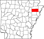
Poinsett County, Arkansas Basics:


Poinsett County Arkansas - Government Site

Population: 24,270
Area: 758 square miles
County seat: Harrisburg
Area code(s) in use: 870
Time zone: CST
High school graduate or higher: 72.9%
Bachelor's degree or higher: 8.9%
Median household income: $31,743
Persons in poverty: 26.8%
Home ownership rate: 63.3%
Mean travel time to work: 23.5 minutes


Adjacent counties:
Craighead  Crittenden  Cross  Jackson  Mississippi  

Find in Arkansas

Map of the Poinsett County area


Our detail map of Poinsett County shows the Poinsett County, Arkansas boundary lines and other interesting items.

Places in Poinsett County, Arkansas

  Airports     show all on map

Helm Landing Strip, Horst Landing Strip, Keller Airfield, Marked Tree Municipal Airport, Pecks Landing Strip, Sally Wofford Airport, Weiner Landing Field, Woodbridge Field Airport

  Bars     show all on map

Cummins Bar

  Bends     show all on map

Cahill Bend, Cow Island

  Buildings     show all on map

Campbell Civic Center, Central Volunteer Fire Department, Fisher Volunteer Fire Department, Harrisburg Police Department, Harrisburg Volunteer Fire Station, Lepanto Police Department, Lepanto Volunteer Fire Department, Marked Tree Police Department, Marked Tree Volunteer Fire Station, Medic One Harrisburg, Melody Nursing Home, Poinsett County Courthouse, Poinsett County Sheriff's Office, Riverside Emergency Medical Service, Trumann Ambulance Service, Trumann City Hall, Trumann Fire Station, Trumann Police Department, Tyronza Fire Department Ambulance, Tyronza Police Department, Tyronza Volunteer Fire Department, Weiner Fire Department Station 1, Weiner Fire Department Station 2, Weiner Police Department

  Canals     show all on map

Ash Spread Ditch, Ditch Number 1, Ditch Number 1, Ditch Number 1, Ditch Number 10, Ditch Number 10, Ditch Number 103, Ditch Number 105, Ditch Number 108, Ditch Number 109, Ditch Number 11, Ditch Number 12, Ditch Number 12, Ditch Number 13, Ditch Number 14, Ditch Number 15, Ditch Number 15, Ditch Number 16, Ditch Number 17, Ditch Number 18, Ditch Number 19, Ditch Number 2, Ditch Number 2, Ditch Number 20, Ditch Number 21, Ditch Number 23, Ditch Number 23, Ditch Number 24, Ditch Number 24, Ditch Number 25, Ditch Number 25, Ditch Number 26, Ditch Number 27, Ditch Number 28, Ditch Number 29, Ditch Number 2a, Ditch Number 3, Ditch Number 30, Ditch Number 31, Ditch Number 32, Ditch Number 33, Ditch Number 34, Ditch Number 35, Ditch Number 36, Ditch Number 37, Ditch Number 38, Ditch Number 39, Ditch Number 4, Ditch Number 4, Ditch Number 41, Ditch Number 41a, Ditch Number 42, Ditch Number 42a, Ditch Number 43, Ditch Number 44, Ditch Number 45, Ditch Number 45a, Ditch Number 45b, Ditch Number 47, Ditch Number 47, Ditch Number 47a, Ditch Number 48, Ditch Number 49, Ditch Number 5, Ditch Number 50, Ditch Number 51, Ditch Number 51a, Ditch Number 51b, Ditch Number 52, Ditch Number 53, Ditch Number 54, Ditch Number 54, Ditch Number 55, Ditch Number 56, Ditch Number 57, Ditch Number 57, Ditch Number 59, Ditch Number 6, Ditch Number 6, Ditch Number 60, Ditch Number 61, Ditch Number 63, Ditch Number 65, Ditch Number 68, Ditch Number 69, Ditch Number 7, Ditch Number 7, Ditch Number 71, Ditch Number 72, Ditch Number 73, Ditch Number 74, Ditch Number 77, Ditch Number 78, Ditch Number 79, Ditch Number 8, Ditch Number 81, Ditch Number 83, Ditch Number 84, Ditch Number 85, Ditch Number 86, Ditch Number 86a, Ditch Number 87, Ditch Number 9, Ditch Number 9, Flag Slough Ditch, Landers Ditch, Lateral Number 1, McCoy Ditch, McCracken Ditch, Overcup Ditch, Pecan Lateral, Powers Ditch, Swan Pond Ditch

  Cemeteries     show all on map

Bethel Cemetery, Bolivar Cemetery, Cherry Bean Cemetery, Clark Cemetery, Conaster Cemetery, Dunn Cemetery, East Cemetery, East Tyronza Cemetery, Farm Hill Cemetery, Greenwood Cemetery, Harris Cemetery, Harrisburg Memorial Park, Holly Springs Cemetery, Houston Cemetery, Marked Tree Cemetery, Mount Olive Cemetery, Mount Zion Cemetery, New Bethel Cemetery, Newsom Cemetery, Nichols Cemetery, Pine Rest Cemetery, Potter Memorial Cemetery, Rock of Ages Cemetery, Spear Lake Cemetery, Spencer Cemetery, Tulot Cemetery, Tyer Cemetery, Walker Cemetery, Willis Cemetery, Wilson Cemetery, Woolsey Cemetery, Wyatts Cemetery, Zion Cemetery

  Churches     show all on map

Anderson Tully Baptist Church, Bay Road Church, Bethel Church, Black Oak Baptist Church, Bolivar Church, Burton Chapel, Centerview Church, Cherry Bean Church, Christ Temple Church, Chudy Grove Church, Church of God, Cooper Haines Church, Corner Chapel Baptist Church, Emery Chapel (historical), Faith Baptist Church, Farm Hill United Methodist Church, First General Church, First United Methodist Church, First United Pentecostal Church, Freer Baptist Church, Glaze Church, Greenfield Baptist Church, Harmony Grove Church, Holly Springs Church, Hurds Chapel, Hy-Way Valley Church, Kingdom Hall, Labanon Church, Lebanon Baptist Church, Long Creek Church, Longs Chapel, Maple Grove Baptist Church, McCormick Baptist Church, Missionary Church, Mount Olive Church, Mount Zion Church, Mount Zion Church, Mount Zion Church, Neiswander Baptist Church, New Bethlehem Church, New Hope Church (historical), Oakview Church, Pilgrim Rest Church, Pleasant Grove Baptist Church, Pleasant Grove Church, Pleasant Hill Baptist Church, Pleasant Hill Church (historical), Pleasant Valley Baptist Church, Pleasant Valley United Methodist Church, Promised Land Church, Red Bridge Church, Red Oak Baptist Church, Ridgeview Church, Rising Sun Church, Rivervale Baptist Church, Rock of Ages Church, Saint Church (historical), South McCormick Church, Taps Church, Tulot Church, Valley View Baptist Church, Viva Drive Church of Christ, Walnut Grove Church, Wesley Temple (historical), Wildwood Church, Wiley Crossing Church (historical)

  Dams     show all on map

John Kocher Lake Dam, Lake Hogue Dam, Lake Poinsett Dam, Lonnie Jaynes Lake Dam, Paul Senteny Lake Dam, Poinsett Watershed Site 1 Dam, Poinsett Watershed Site 101 Dam, Poinsett Watershed Site 102 Dam, Poinsett Watershed Site 2 Dam, Poinsett Watershed Site 3 Dam, Wayne Carter Lake Dam

  Flats     show all on map

Caney Bottoms, Cow Island, Hatchie Coon Island, Middle Island, Oak Donnick Floodway, Old River Island, Saint Francis Sunk Lands

  Guts     show all on map

Steep Gut Bayou

  Lakes     show all on map

Dead Timber Lake, Hood Lake, Lost Trap Lake, Snake Slough, Spear Lake

  Locales     show all on map

Fork, Hatchie Coon Hunting Lodge, North Mart Shopping Center, Oak Donnick Club House, Oak Donnick Gage, Safford Spur (historical), Stevens Landing

  Parks     show all on map

Bayou De View State Wildlife Management Area, Bayou DeView Public Hunting Area, Lake Poinsett State Park, North Side Park, Ozark Street Park, Singer Forest Natural Heritage Area, West Side Park

  Populated Places     show all on map

Alto, Anderson Tully, Arthur (historical), Bay Village, Beasley, Black Oak, Boat Run, Brainerd (historical), Brushey Lake, Buffalolick (historical), Carr (historical), Cassidy, Cypress (historical), Deckerville, Dewey Mill, Dobell, Donnick, Dub, Engman (historical), Fisher, Frys Mill, Gaulett, Greenfield, Harrisburg, Hatchie Coon, Huskey, Hydrick, Joyland, Judd Hill, Landers, Lepanto, Maple Grove, Marked Tree, McCormick, McDaniel, Merced (historical), Mount Olive, Mulligan, North Pitts, Northern Ohio, Old Weona, Payneway, Pitts, Promised Land, Rivervale, Ruffin (historical), Shady Grove, Spear Lake, Stacy, Stewart, Trumann, Tulot, Tyronza, Tyronza Junction, Uno, Waldenburg, Walnut Grove Corner, Weed, Weiner, Weona, Weona Junction, Whitaker, Whitehall, Wilbeth, Wiley Crossing, Yellow Banks

  Reservoirs     show all on map

Chase Reservoir, Claypool Reservoir, John Kocher Lake, Keller Lake, Lake Hogue, Lake Poinsett, Lonnie Jaynes Lake, O K Lake, Paul Senteny Lake, Poinsett Watershed Site 101 Reservoir, Poinsett Watershed Site 102 Reservoir, Poinsett Watershed Site One Reservoir, Poinsett Watershed Site Three Reservoir, Poinsett Watershed Site Two Reservoir, Wayne Carter Lake

  Schools     show all on map

Beautiful Home School (historical), Bethel School (historical), Black Oak School (historical), Bolivar School (historical), Brett School (historical), Brushy Lake School (historical), Burrow School (historical), Byrns School (historical), Cedar Park Elementary School, Central High School, Cherry Bean School (historical), Cooper Haines School (historical), Delta Vocational Technical School, East Poinsett County Elementary School, East Poinsett County High School, East Poinsett County Junior High School, Freer School, Greenwood School (historical), Harrisburg Elementary School, Harrisburg High School, Harrisburg Middle School, Hickory Grove School (historical), Jernigan School, Judd Hill School (historical), L'Anguille School (historical), Lepanto Elementary School, Locust Grove School (historical), Maple Grove School (historical), Mardis School (historical), Marked Tree Elementary School, Marked Tree High School, Morning Sun School (historical), New Bethlehem School (historical), Normandy Elementary School, Oak Grove School (historical), Perkins School (historical), Pine View School (historical), Promised Land School (historical), Red Oak School, Shady Grove School (historical), Shiloh School (historical), Spear Lake School (historical), Thorn School, Trumann High School, Tulot School, Tyronza Elementary School, Ukana School (historical), Valley View School (historical), Webb School (historical), Weiner Elementary School, Weiner High School, Whitaker School, Wildwood School, Wiley Crossing School (historical)

  Streams     show all on map

Ash Spread, Bale Brown Branch, Barker Creek, Bear Branch, Big Creek, Bolivar Creek, Cooper Branch, Cross Bayou, Dillard Cut off, Distress Creek, England Creek, Ganaway Creek, Gum Slough, Hollow Branch, Holly Springs Branch, Hydrick Creek, Iron Mines Creek, Kaylo Creek, Lead Fork, Lead Fork, Left Hand Chute of Little River, Long Creek, Mardis Branch, Mink Slough, Morgan Slough, Old Channel Cache River, Old Forked Slough, One Mile Branch, Otter Creek, Powers Slough, Raccoon Bayou, Right Hand Chute Little River, Sand Slough, Threemile Creek

  Summits     show all on map

Miller Mound

  Swamps     show all on map

Hatchie Coon Lake, Saint Francis Lake

  Towers     show all on map

KPCA-AM (Marked Tree), KXHW-FM (Marked Tree), KXRQ-AM (Trumann),

Poinsett County, Arkansas Population By Race (2012 estimate)

RacePopulation
WhitePoinsett County White population 21,94021,940  
BlackPoinsett County Black population 1,8691,868
MixedPoinsett County Mixed population 316315
American IndianPoinsett County American Indian population 7372
Hawaiian & Pacific IslanderPoinsett County Hawaiian & Pacific Islander population 00

Additional population tables :
State population table
Arkansas population by county