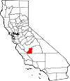
Kings County, California Basics:


Kings County California - Government Site

Population: 151,382
Area: 1389 square miles
County seat: Hanford
Area code(s) in use: 559
Time zone: PST
High school graduate or higher: 71.3%
Bachelor's degree or higher: 12.4%
Median household income: $48,761
Persons in poverty: 20.7%
Home ownership rate: 52.8%
Mean travel time to work: 21.1 minutes


Adjacent counties:
Fresno  Kern  Monterey  San Luis Obispo  Tulare  

Find in California

Map of the Kings County area


Our detail map of Kings County shows the Kings County, California boundary lines and other interesting items.

Places in Kings County, California

  Airports     show all on map

Avenal Airport, Blair Strip (historical), Corcoran Airport, El Rico Airport, Hanford Community Medical Center Helistop, Hanford Municipal Airport, Ianni Strip, Jones Farms Airport, Lemoore Naval Air Station (Reeves Field), Machado Dusters Airport, Newton Field Airport, Salyer Farms Airport, Stone Airstrip, Stone Land Co Airport, Swanson Ranch Nr 1 Airport, Vineyard Oaks Farm Airport, Westlake Farms Airport

  Areas     show all on map

California Region - 2-digit Hydrologic Unit Code - 18

  Basins     show all on map

La Caldera, La Escudilla, La Marmita, Sunflower Valley, The Turtle Hole

  Buildings     show all on map

American Ambulance, American Ambulance, American Ambulance, American Ambulance, American Ambulance, American Ambulance Kings County Headquarters, Avenal Branch Kings County Library, Avenal City Hall, Avenal District Hospital Ambulance Service, Avenal State Prison, Avenal State Prison Fire Department, California State Prison - Corcoran, Carnegie Museum, Corcoran Branch Kings County Library, Corcoran City Hall, Corcoran Family YMCA, Corcoran State Prison Fire Department, Corcoran Unified School District Office, Eleven P Office, Hanford Branch Kings County Library, Hanford City Hall, Hanford Fire Department Station 1, Hanford Fire Department Station 2, Hanford Free Public Library (historical), Kate H Boswell Seniors Center, Kettleman City Branch Kings County Library, Kings Art Center, Kings County Courthouse, Kings County Fire Department Station 1 Burris Park, Kings County Fire Department Station 10 Stratford, Kings County Fire Department Station 11 Corcoran, Kings County Fire Department Station 12 Avenal, Kings County Fire Department Station 2 Hardwick, Kings County Fire Department Station 4 South Hanford, Kings County Fire Department Station 5 Armona, Kings County Fire Department Station 6 Island, Kings County Fire Department Station 7 South Lemoore, Kings County Fire Department Station 9 Kettleman City, Kings County Free Library, Kings County Jail, Lemoore Branch Kings County Library, Lemoore City Hall, Lemoore Civic Auditorium, Lemoore Volunteer Fire Department, Lemoore Volunteer Fire Department North Side Station, Longfield Recreation Center, Naval Air Station Lemoore Federal Fire Department, Naval Air Station Lemoore Federal Fire Department Operations Crash Station, Rhodes Cabin (historical), SkyLife of Central California Air Ambulance, Stratford Branch Kings County Library, Taylor Cabin, Veterans Memorial Building, Veterans Memorial Building, Veterans Memorial Hall

  Canals     show all on map

Ax Canal, Bean Ditch, Blakeley Canal, Burk Side Ditch, Center Branch, Childress Ditch, Daulton Ditch, Dutch John Cut, E Canal, East Branch Lakeside Ditch, East Branch Peoples Ditch, East Hansen Fisk Ditch, El Rico Main Canal, Empire Canal, Empire Westside Ditch, Empire Westside Main Canal, Gates-Jones Canal, Guiberson Canal, Hacienda Spillway, Harp Ditch, Helm-Lewis Ditch, Highline Canal, Homeland Canal, Independent Ditch, Island Canal, Island Canal, Jacobs Canal, Jacobs Ditch, Kimble Ditch, Lakeland Canal, Lakeside Ditch, Lamberson Ditch, Last Chance Ditch, Last Chance Ditch, Lateral A, Lateral B, Lateral B, Lateral F, Lemoore Canal, Lewis Ditch, Liberty Farms East Canal, Liberty Farms South Canal, Lone Oak Canal, Lower Kings River Ditch, Main Canal, Main Island Canal, McCrary Side Ditch, Melga Canal, New Deal Canal, North Branch Island Canal, North Corcoran Ditch, North Hansen Fisk Ditch, Peoples Ditch, Poso Canal, Reclamation Ditch, Riverside Ditch, Settlers Ditch, South Branch Island Canal, South Branch Island Canal, South Branch Summit Lake Ditch, Sperry Lateral, Stratford Canal, Sweet Canal, Tulare Lake Canal, West Branch Lakeland Canal, West Branch Last Chance Ditch, West Corcoran Ditch, Wilbur Ditch

  Cemeteries     show all on map

Calvary Cemetery, Corcoran Memorial Park, Hanford Cemetery, Kings River Cemetery, Lakeside Cemetery, Lemoore Cemetery

  Census     show all on map

Armona Census Designated Place, Grangeville Census Designated Place, Hardwick Census Designated Place, Home Garden Census Designated Place, Kettleman City Census Designated Place, Lemoore Station Census Designated Place, Stratford Census Designated Place

  Churches     show all on map

Apostolic Assembly of the Faith in Christ Jesus Church, Body of Christ Ministries, Calliers Crusaders Church, Calvary Chapel of Hanford, Church of Christ, Church of Christ, Church of God, Church of God, Church of Revelation, Church of the Nazarene, Church of the Nazarene, Crossroads Christian Fellowship Church, Episcopal Church of the Epiphany, Episcopal Church of the Savior, Federated Church, First Baptist Church, First Baptist Church, First Christian Church, First Church of Christ Scientist, First Conservative Baptist Church (historical), First Lutheran Church, First Missionary Baptist Church, First Pentecostal Church, First Presbyterian Church, First Presbyterian Church, First Southern Baptist Church, First United Methodist Church, First United Methodist Church of Hanford, First United Presbyterian Church, Folsom Temple Church of God in Christ, Free Methodist Church, Glad Tidings Assembly of God Church, Golden Harvest Apostolic Church, Grace Temple Pentecostal Holiness Church, Hanford Buddist Church, Hanford Spanish Seventh Day Adventist Church, Howard Chapter African Methodist Episcopal Zion Church, Iglesia Cristiana Amigos de Israel, Island Church, Kingdom Hall of Jehovahs Witnesses, Kings Christian Fellowship Foursquare Church, Koinonia Christian Fellowship Church, Last Days Ministries of Jesus Christ, Latin American Assembly of God Church, Lemoore Baptist Church, Mexican Mission Baptist Church, New Hope Orthodox Presbyterian Church, New Light Baptist Church, Our Lady of Lourdes Catholic Church, Pentecostal Church of God, Pentecostal Church of God, Primera Iglesia Bautista del Sur, Saint Brigids Roman Catholic Church, Saint Cecilias Catholic Church, Saint Peters Roman Catholic Church, Salvation Army Church, Second Baptist Church, Seventh Day Adventist Church, Seventh Day Adventist Church, Southside Church of God, The Church of Jesus Christ of Latter Day Saints, Triple L Christian Center, Victory Outreach Hanford Church

  Dams     show all on map

Collis Levee, Crescent Weir, Crescent Weir 84, Empire Weir Number One, Empire Weir Number Two, Island Weir, Last Chance Weir 723, New Island Weir, Peoples Weir 79

  Flats     show all on map

El Rinc�n, Hay Flat, La Cuna, La Llanura, La Rambla, La Vega, Tulare Lake Bed

  Gaps     show all on map

Avenal Gap, Deadman Gap, El Campo, El Paso, El Portillo, La Brecha, La Porter�a, La Salida

  Guts     show all on map

Boggs Slough, Crooked Slough, Green Slough, Guernesy Slough, Lone Oak Slough, Mussel Slough, Sand Slough, Sand Slough

  Hospitals     show all on map

Adventist Medical Center Hanford, Avenal Hospital, Central Valley General Hospital, Corcoran District Hospital, Hanford Community Medical Center, Kings County General Hospital, Kings County Health Clinic, Naval Hospital Lemoore

  Islands     show all on map

Pelican Island

  Levees     show all on map

Boswell Levee, Cohn Levee, El Rico Levee, Goldberg Levee, Liberty Farms West Side Levee, Lovelace Levee, North Central Levee, Progressive Levee

  Locales     show all on map

Armona Industrial Park, Atsma - Cameron Dairy, Avenal Landfill, Avila And Fernandes Dairy, Bad Water Ranch, Benfica Dairy, Boswell Camp One, Boy Scout Camp, Cadillac Ranch Dairy, Caetano Dairy, Centennial Plaza Shopping Center, Central Union Grange, Chatom Ranch (historical), China Alley, Clark Ranch, Cloverdale Dairy, Corcoran High School Agricultural Farm, Corcoran Prison Dairy, Corcoran Substation, Crockett and Gambogy Labor Camp, Crockett and Gambogy Ranch, Cross Creek Dairy, Cunha Dairy East, Diamond D Dairy, Dias and Dias Dairy Complex, Diman G Dairy, Double N Dairy, Double O Ranch, Dover Dairy, Droogh Dairy, Dudley Pump Station (historical), Eden - Vale Dairy, Eighteen Q Camp, El Rico Ranch, Eleven P Plant, Fagundes Ranch, Felicita Dairy, Fernandes Dairy, Five J's Dairy, Flint Dairy, Flying M Ranch, Glendora School, Goodfellow Ranch (historical), Hacienda Ranch, Hakker Dairy, Hanford Mall Shopping Center, Hanford Towne Center Shopping Center, Harvester Ranch (historical), Henrietta Substation, Holland's Dairy, Hollandia Farms North Dairy, Houser Camp, Iron Spring Ranch, J C J Dairy, Johnson Ranch, Jones Ranch (historical), JVD Dairy, Kansas Holstein Dairy, Kettleman Compressor Station, Kettleman Hills Compressor Station, King's Ranch, Kings County Country Club, Kings County Government Center, Kings County Honor Farm, Kings Drive-In, Kings Industrial Park, Larry Davis Farms, Las Perillas Pumping Plant, Lemoore Golf Course, Lemoore Industrial Park, Lemoore Plaza Shopping Center, Lemoore Square Shopping Center, Lima Dairy, Log Haven Dairy, Lone Oak Farms Number 1, Lone Star Dairy, Lu-Ar Dairy, Manzanillo Ranch, Mattos Brothers Dairy, Mick Olibeira Farm, Midlake Substation, Murray Fire Control Station, North Fork School, Orchard Ranch, Overland Ranch, Paddock School, Parreira Dairy, Pedro Dairy, Peterson Ranch, Phil Vannette Dairy, Phoenix Dairy, Pumping Station Number 2, Pumping Station Number 2A, Richland Farms Camp, Riley Camp, River Ranch, River Ranch Dairy, Russ Waymire Farms, Sandoll Ranch (historical), Segaser Ranch, South Fork Ranch, South Lake Farms, Sozinho Dairy, Sozinho Dairy Number 2, State Division of Forestry, Stratford Industrial Area, Stratford Ranch, Stryd Brothers Ranch, Taylor Cabin, Te Velde Bernard Dairy, Three P Plant, Tony Martin Dairy, Triple F Ranch, Valadao Dairy, Valley View Farms Dairy, Warmerdam Dairy, Warmerdam Orchards, Wayne School, West Creek Dairy, West Lake Farms, West Tulare Lands Ranch, Willow Grove Farms Dairy, Wolfson Ranch (historical), Wreden Ranch Dairy, Yost Cabin, Youd School

  Military     show all on map

Naval Air Station Lemoore

  Mines     show all on map

Avenal Canyon Mine, Dawson Mine, Kings Mine

  Parks     show all on map

Burnham Smith Park, Burris Park, Civic Center Park, Cob Park, Corcoran City Swimming Pool, Earl Johnson Park, El Adobe de los Robles Historic Park, Father Wyatt Park, Floyd Rice Park, Heritage Park, Hidden Valley Park, John Maroot Park, Kings County Fairgrounds, Kingston Historical Marker, Lacy Park, Mussel Slough Tragedy Historical Marker, Westfield Park

  Plains     show all on map

Kettleman Plain

  Populated Places     show all on map

Acebedo, Armona, Avenal, Banner (historical), Bean (historical), Bel Air Mobile Home Park, Cimarron, Corcoran, Cornwell (historical), Cuneo (historical), El Dorado Mobile Home Park, Fort Roosevelt, Four Seasons Mobile And Recreational Vehicle Park, Gepford, Grangeville, Guernsey, Halls Corner, Hamblin, Hanford, Hanford Del Arroyo Estates, Hardwick, Hasset (historical), Helm Corner, Home Garden, Hub, Hydril, Kettleman City, Kettleman Station, Kimble (historical), Kings Mobile Home Estates, Kingston (historical), Lemoore, Lethent (historical), Lucerne, Magnolia Gardens Mobile Home Park, Marsala (historical), Millham City (historical), Murray, Odessa (historical), Orion (historical), Pitco, Reef Station, Remnoy, Rossi, Shell, Shirley, Sierra Vista Mobile Estates, South Corcoran, Stratford, Tara Mobile Estates, Whitley Manor Mobile Home Park

  Post Offices     show all on map

Armona Post Office, Avenal Post Office, Corcoran Post Office, Hanford Post Office, Kettleman City Post Office, Lemoore Post Office, Stratford Post Office

  Ranges     show all on map

Chalk Buttes, Kettleman Hills, Las Alturas, Las Colinas, Las Lomas, Los Jinetes, Los Viejos, Pyramid Hills

  Ridges     show all on map

Avenal Ridge, Bullwheel Ridge, Discovery Ridge, Double Hill, Drillers Ridge, Dudley Ridge, El Arco, El Caballete, El Serrij�n, La Aleta, La Loba, La Muralla, La Tusa, Las Paredes, Las Perillas, Los M�danos, Mid Ridge, Middle Dome, North Dome, Pintojo Ridge, Reef Ridge, Sand Ridge, Tent Hills

  Schools     show all on map

Armona Elementary School, Armona Union Academy, Avenal Elementary School, Avenal High School, Bret Harte Elementary School, Central Union School, Cleveland School, Corcoran High School, Crescent School (historical), Cross Creek School (historical), Dallas School, Dallas School (historical), Delta View Elementary School, Earl F Johnson High School, Empire School (historical), Eucalyptus School (historical), Eureka School (historical), Excelsior School, First Baptist Playschool, First Lutheran Church Preschool, Frazer School (historical), Gardenside Elementary School, George Washington Elementary School, Glendora School (historical), Hanford Christian School, Hanford High Night Continuation School, Hanford High School, Hanford High School West Campus, Island Elementary School, Jacobs School (historical), Jamison High School, Jefferson Elementary School, Jefferson School (historical), John C Fremont Elementary School, John Muir Junior High School, Kettleman City Elementary School, King School (historical), Kings Christian Elementary School, Kings County School for Physically Handicapped Children, Kings Lake High School, Kings River School, Kit Carson Elementary School, Lakeside Elementary School, Lee Richmond Elementary School, Lemoore Adult School, Lemoore Elementary School, Lemoore High School, Liberty Intermediate School, Lincoln Elementary School, Lincoln School (historical), Manzanillo School, Mark Twain Elementary School, Mary Immaculate Queen School, Masters School, Meadow Lane Elementary School, Mid Valley Alternative Charter Homeschool, Monroe School, Mussel Slough School (historical), Neutra Elementary School, New Home School (historical), P W Engvall Middle School, Parkview Middle School, Pioneer Primary School, Reef-Sunset Middle School, River Bend School, Roosevelt Elementary School, Rustic School (historical), San Jose School, Stratford Elementary School, Sunrise High School, Tensmuir School (historical), Thomas McCarthy Memorial School, Willow Grove School, Woodrow Wilson Elementary School

  Slopes     show all on map

La Bajada

  Springs     show all on map

Dirty Spring, Double Spring, Roof Spring, Sulphur Spring, Vaquero Spring, Wade Baxter Spring, Willow Spring

  Streams     show all on map

Arroyo Bifido, Arroyo Chico, Arroyo Conchoso, Arroyo Culebrino, Arroyo Curvo, Arroyo Degollado, Arroyo del Camino, Arroyo del Conejo, Arroyo del Paso, Arroyo Delgado, Arroyo Doblegado, Arroyo Escaso, Arroyo Esquinado, Arroyo Estrecho, Arroyo Finito, Arroyo Hondo, Arroyo Larguito, Arroyo Mellado, Arroyo Menudo, Arroyo Murado, Arroyo Peque�o, Arroyo Petreo, Arroyo Pino, Arroyo Ramoso, Arroyo Raso, Arroyo Recodo, Arroyo Robador, Arroyo Somero, Arroyo Torcido, Arroyo Tozo, Avenal Creek, Baby King Creek, Big Tar Creek, Bull Slough, Clarks Fork Kings River, Cottonwood Creek, Cross Creek, East Branch Cross Creek, East Branch Cross Creek, Faull Slough, Guernsey Slough, Jacobs Slough, Kern River Channel, Kings River, Little Avenal Creek, Middle Branch Cross Creek, Mill Creek, Mosquito Creek, North Fork Kings River, South Fork Kings River, Tule River, West Branch Cross Creek

  Summits     show all on map

Badger Hill, Block Hill, Boulder Hill, Broken Hill, Cerro Alto, Cerro Lodoso, Cerro Ultimo, Dombo, El Bulto, El Chichon, El Collado, El Dombo, El Le�n, El Lobo, El Loro, El Mirador, El P�jaro, El Perno, El Perro, El Piso, El Pulgar, El Rabo, El Rascador, El Taco, El Tolete, Flattop, Garza Peak, Hydril Hill, Johnson Peak, La Cima, La Clavija, La Cuba, La Cuesta, La Cumbre, La Lomica, La Meseta, La Morra, La Oveja, La Palomera, Mesa Roida, Mustang Hill, Oyster Hill, Parejo Hill, Pipe Hill, Ragged Top, Roundtop, Tar Peak, Three Peaks, Zwang Peak

  Towers     show all on map

KIGS-AM (Hanford), KJET-FM (Kingsburg), KJET-FM (Kingsburg), KJOP-AM (Lemoore), KNGS-FM (Coalinga), KQIQ-AM (Farmersville), KQIQ-AM (Lemoore), KQYZ-FM (Lemoore), KQYZ-FM (Lemoore), Pyramid Hills Microwave Relay Station

  Valleys     show all on map

Avenal Canyon, Baby King Canyon, Big Tar Canyon, Bullpen Canyon, Catskin Canyon, Cottonwood Canyon, Falls Canyon, Horse Canyon, La Zanja, Little Tar Canyon, Lovel Canyon, Pepper Grass Valley, Poison Oak Canyon, Sulphur Spring Canyon, Sulphur Spring Canyon, Willow Spring Canyon,

Kings County, California Population By Race (2012 estimate)

RacePopulation
WhiteKings County White population 123,225123,224  
BlackKings County Black population 11,35411,353
AsianKings County Asian population 6,5096,509
MixedKings County Mixed population 5,2985,298
American IndianKings County American Indian population 4,5414,541
Hawaiian & Pacific IslanderKings County Hawaiian & Pacific Islander population 454454

Additional population tables :
State population table
California population by county