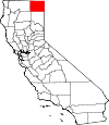
Modoc County, California Basics:


Modoc County California - Government Site

Population: 9,346
Area: 3918 square miles
County seat: Alturas
Area code(s) in use: 530
Time zone: PST
High school graduate or higher: 85.1%
Bachelor's degree or higher: 19.4%
Median household income: $37,482
Persons in poverty: 19.9%
Home ownership rate: 72.6%
Mean travel time to work: 17.5 minutes


Adjacent counties:
Klamath (OR)  Lake (OR)  Lassen  Shasta  Siskiyou  Washoe (NV)  

Find in California

Map of the Modoc County area


Our detail map of Modoc County shows the Modoc County, California boundary lines and other interesting items.

Places in Modoc County, California

  Airports     show all on map

Adin Airport, Alturas Municipal Airport, Bates Field Airport, California Pines Airport, Cedarville Airport, Devils Garden Airport, Eagleville Airport, Fort Bidwell Airport, Likely Airport, Tulelake Municipal Airport, Wesinger Ranch Airport, Winema Airstrip

  Arches     show all on map

Modoc Natural Bridge

  Areas     show all on map

Alturas Agricultural Inspection Station, Copic Bay, Indian Meadow

  Basins     show all on map

Dry Creek Basin, Hager Basin, Joseph Creek Basin, Little Valley, North Star Basin, Pine Creek Basin

  Bridges     show all on map

Canby Bridge

  Buildings     show all on map

Adin Fire Protection District, Alturas City Fire Department, Alturas Police Department, Alturas Rural Fire Protection District, Bureau of Land Management Surprise Field Office, California Department of Forestry and Fire Protection Lassen Modoc Unit Alturas, California Department of Forestry and Fire Protection Lassen Modoc Unit Deer Springs, California Highway Patrol Alturas, California Pines Lake Fire Station, Canby Fire Protection District, Cedarville Fire Protection District, Conklin Sawmill (historical), Davis Creek Volunteer Fire Department, Deer Springs Fire Protection District, Department of Forestry and Fire Protection Lassen Modoc Unit / Happy Camp Fire Station, Eagleville Fire Protection District, Fort Bidwell Indian Community Council, Lake City Fire Protection District, Likely Fire Department, Likely Volunteer Fire Protection District, Lookout Fire Protection District, Lookout Fire Protection District Rancheria, Modoc County Courthouse, Modoc County Sheriff's Office, Willow Ranch Fire Protection District

  Canals     show all on map

Bare Creek Ditch, Eastside Canal, Oilar Ditch, Peterson Ditch, Rattlesnake Ditch, Schadler Ditch, Westside Canal

  Capes     show all on map

Bloody Point, Cape Horne, McGinty Point, Scorpion Point, The Peninsula, The U

  Cemeteries     show all on map

Adin Cemetery, Cedarville Cemetery, Eagleville Cemetery, Indian Cemetery, Indian Cemetery, Indian Cemetery, Likely Cemetery, Willow Ranch Cemetery

  Census     show all on map

Adin Census Designated Place, California Pines Census Designated Place, Canby Census Designated Place, Cedarville Census Designated Place, Daphnedale Park Census Designated Place, Eagleville Census Designated Place, Fort Bidwell Census Designated Place, Lake City Census Designated Place, Likely Census Designated Place, Lookout Census Designated Place, New Pine Creek Census Designated Place, Newell Census Designated Place

  Churches     show all on map

Alturas Baptist Church, Alturas Gospel Mission, Alturas Seventh Day Adventist Church, Bahai Faith Church, Christian Life Assembly Church, Church of Christ, Church of the Nazarene, Faith Baptist Church, Kingdom Hall of Jehovahs Witnesses, Sacred Heart Catholic Church, Saint Michaels Episcopal Church

  Cliffs     show all on map

Dry Creek Rim, Noble Bluff, Porcupine Rim, Porcupine Rim, The Cliffs

  Dams     show all on map

A and C 1110-002 Dam, Bayley Reservoir 1118 Dam, Big Dobe North 129 Dam, Big Dobe South 129-002 Dam, Big Johnson 1116 Dam, Big Sage 55-000 Dam, Big Sage Dam, Blue Lake Dam, Boggs and Warren 1120 Dam, Burger 1117 Dam, Carpenter Wilson 172-002 Dam, Clarke 174 Dam, Clear Lake Dam, Clear Lake Dike Dam, Cloverswale 112-003 Dam, Cummings Reservoir Number 1 148 Dam, Curtis-Capik 128 Dam, Dannhauser 161 Dam, Davis Creek Orchards 127-002 Dam, Dead Horse Flat Dam, Donovan 179 Dam, Dorris Dam, Duncan 149-002 Dam, Enquist 158 Dam, Graven 136-002 Dam, Hackamore Reservoir Dam, Hines Brothers 1114 Dam, Householder Dam, Huffman Antelope 112-002 Dam, Ingals Swamp 141-002 Dam, James Porter 1123-002 Dam, Janes Flat 121 Dam, Kelley and Greiner 133 Dam, Kramer 156-006 Dam, Lauer Dam, Leonard Johnson 173-002 Dam, Lindauer Concrete 1110 Dam, Little Juniper 136 Dam, Lookout 164 Dam, McBrien 110 Dam, McGinty Dam, Mud Lake 129-005 Dam, Payne 143 Dam, Pickering Lumber 111 Dam, Plum Canyon 139 Dam, Poison Springs 1113 Dam, Renner Sibley Creek 1119 Dam, Roberts 157-002 Dam, Rye Grass Swale 150 Dam, S X 112 Dam, Schadler 1122 Dam, Shedd 1121 Dam, Spaulding 3 Dam, Taylor Creek Number 1 114 Dam, Telephone Flat Reservoir Dam, Thomas Briles 171 Dam, Toreson 153 Dam, Upper Pasture 161-002 Dam, West Valley Dam, White 151 Dam, Woods Place Dam

  Falls     show all on map

Mill Creek Falls

  Flats     show all on map

Armentrout Flat, Bear Flat, Bearcamp Flat, Benton Meadow, Bob Young Flat, Boles Meadow, Buchanan Flat, Cottonwood Flat, Cottonwood Flat, Coyote Flat, Coyote Meadow, Devils Garden, Dixon Flat, Dobie Flat, Dutch Flat, Dutch Flat, Fender Flat, Fiddlers Green, Flournoy Swale, Fox Flat, Gas Drum Flat, Gasper Meadow, Hacker Flat, Halls Meadows, Harris Flat, Henderson Meadow, Hess Flat, Higgins Flat, Hollenbeck Flat, Homestead Flat, Howard Flat, Indian Meadow, Island Meadow, Jims Flat, Keeney Flat, Knox Flat, Liza Large Flat, Long Meadow, Mac Afee Flat, McKay Flat, Mill Creek Meadows, Miller Flat, Niles Flat, O'Connors Flat, O'Leary Flat, Patterson Meadow, Pease Flat, Poison Flat, Rail Meadow, Rice Flat, Rocky Prairie, Roney Flat, Round Willows, Saddle Blanket Flat, Sand Flat, Service Flat, Sevenmile Flat, Sweagert Flat, The Frog Pond, The Panhandle, Tom Large Flat, Tom Lee Meadows, Twelvemile Meadow, Walter Flat, Webb Flat

  Forests     show all on map

Modoc National Forest

  Gaps     show all on map

Adin Pass, Cedar Pass, Fandango Pass, Hopeless Pass

  Hospitals     show all on map

Modoc Medical Center, Surprise Valley Community Hospital

  Islands     show all on map

Bird Island, Hansen Island, Lands Island, Snake Island, Stone Island

  Lakes     show all on map

Adin Summit Pond, Alkali Lake, Antelope Plains, Ben Eberli Waterhole, Big Mud Lake, Big Waterhole, Bishop Lake, Cambron Lake, Cave Lake, Clear Lake, Cottonwood Lake, Cow Head Lake, Crystal Waterhole, Cummins Lake, Curtis Waterhole, Deep Waterhole, Delta Lake, Double Head Lake, Dry Lake, Duck Hole, Duck Pond, Dustys Waterhole, Frog Waterhole, Goose Lake, Goose Lake (historical), Goose Pond, Harvey Lake, Hog Lake, Lake Annie, Lava Lake, Lily Lake, Lindemenn Lake, Little Egg Lake, Little Mud Lake, Lone Pine Lake, Lower Lake, Middle Alkali Lake, Mosquito Lake, Mosquito Lake, Mud Lake, Mud Lake, Mud Lake, Mud Lake, North Emerson Lake, Patterson Lake, Pinnacle Lake, Poison Lake, Rack Lake, Red Lake, Rimrock Lake, Sage Lake, Snake Lake, Snow Lake, South Emerson Lake, Stovepipe Flat, Twin Lakes, Twin Lakes, Upper Lake, Upper Mud Lake, Wet Weather Pond

  Lava     show all on map

Little Lavas

  Locales     show all on map

Adin station, Ainshea Butte, Allen Camp (historical), Alturas Yard, Ambrose Station (historical), Ambrose Station Pumphouse, Area of Modoc War Fortifications, Area of War Fortifications, Avanzino Ranch, Bacon Ranch (historical), Battle of Dry Lake 1873, Battle of Lands Ranch, Battle of Scorpion Point, Beaver Dam Cabin, Beet Camp, Bennen, Big Crack, Big Lakes Camp, Big Sage Campground, Big Valley Ranger Station, Bowman Ranch, Boyd Spring Ranch, Brooks, Buck Creek Guard Station, Bunyard Ranch, Bureau of Land Management Fire Guard Station, Cave Lake Campground, Cedar Pass Campground, Cedar Pass Ski Area, Chandler Ranch, Cidar Pass Ski Course, Cockrell Ranch, Coop, Copco (historical), Corporation Ranch, Cottonwood Flat Campground, Cottonwood Flat Campground, Cove Ranch, Crowder Flat Ranger Station, Crowder Flat Station, Crowder Flat Station, Crowder Ranch, Dalton Ranch, Devils Garden Ranger Station, Dry Lake Forest Service Station, Dry Lake Guard Station, E Ranch, East Wildlife Overlook, Emerson Camp, Emerson Recreation Site, Everly Ranch, Fitzhigh Creek Ranch, Flournoy Ranch, Gerig Camp, Goose Lake Reservoir Boat Ramp, Grohs Ranch, Hager Ranch, Happy Camp Forest Service Station, Hastings Ranch, Hayes, Head of Rush Creek Campground (historical), Hill Ranch, Hilton, Holbrook Ranch, Homestead Well, Horse Camp, Howards Gulch Campground, Indian Springs, Ingalls Swamp Ranch, Jim Horn Ranch, Joiner, Joseph Creek Ranch, Lakeshore Ranch, Larry Flat Campground, Lava Campground, Lilly Lake Picnic Area, Liskey, Little Meadows Campground, Log Landing, Long Bell Forest Service Station, Lookout Rancheria, Lookout Siding, Lower Rush Creek Campground, Mammoth, Manuels Camp, McArthur Cow Camp, McNeil Ranch, Meares, Meeks Place, Midra Ranch, Mike Faine Ranch, Mill Creek Falls Campground, Modoc County Fairground, Modoc Peatmoss Company, Monchamp, Mount Stevenson Ranch, Mount Vida Vista Scene Viewpoint, Old Baker Cabin, Old Camp One, Old Elliot Ranch, Old Likely Mill (historical), Parman Ranch, Patterson Guard Station, Patterson Recreation Site, Pease Cabin, Pepperdine Camp, Planters Camp, Plum Valley Campground, Point Ranch, Potter Sawmill, Pumice Brick Plant, Pundy Ranch, Redwood Gun Club, Reservoir C Campground, Roberts Camp, Round Valley Ranch, Sallys Camp, Scammons Arrowhead Ranch, Site of Fandango Massacre, Soup Spring Campground, Steele Swamp Ranch, Stough Campground, Timber Mountain Ranch, Tom Smith Cabin, Triangle Headquarters, Tule Lake War Relocation Camp (historical), Turner Ranch, Ulbright, Upper Rush Creek Campground, Warner Mountain Ranger Station, Weed Valley Ranch, West Valley Ranch, Wild Horse Cow Camp, Willow Creek Ranch, Wilson Patch Ranch, Yankee Jim Ranch

  Mines     show all on map

Blue Bell Mine, Consolidated Mine, Horse Mountain Quarry, Klondyke Mines, Little Lily Mine, Lost Cabin Mine, Modoc Mines, Moonlight Mines, Morgan Ranch Pit, Morrel Mine, Rainbow Mine, Sunshine Mine

  Parks     show all on map

Ash Creek Wildlife Area, Chimney Rock Historical Monument, Clear Lake National Wildlife Refuge, Evans and Bailey Historical Monument, Infernal Caverns Battleground Memorial Monument, Long Bell State Game Refuge 1N, Modoc National Wildlife Refuge, World War II Valor in the Pacific National Monument

  Pillars     show all on map

City Rock, Day Rock, Hanging Rock, Prisoners Rock, Sheep Rock, Signal Rock

  Populated Places     show all on map

Adin, Alturas, Ambrose, Astakiwi (historical), Bayley (historical), Boles, Bormister, Brooks Mill, California Pines, Campbell, Canby, Cantrall Mill, Cedarville, Christensen, Chumawi (historical), Copic, Cornell, D Flourney, Dalton, Daphnedale Park, Davis Creek, Day, Demuth, Derner, Dibble Place, Eagleville, Fairport, Fletcher (historical), Fletcher Place, Fort Bidwell, Grizzlie Place, Hackamore, Hannchen, Harper, Hollenbeck (historical), Homestead, Juniper, K Flourney, Kalina, Kandra, Kauffman, Kephart, Keshlakchuis (historical), Keuchishkeni (historical), Lake City, Lakeview Junction, Likely, Liskey, Lookout, Lookout Junction, Mammoth, McArthur, McGarva, Meares, Menlo Baths, Mulkey Place, New Pine Creek, Newell, Old Hulbert Place, Paola (historical), Perez, R Flourney, Ramsey, Scarface, Staley, Stronghold, Surprise Station, Suty (historical), Tionesta, Tuber, Vestil, White Horse, Williams, Willow Ranch

  Post Offices     show all on map

Adin Post Office, Alturas Post Office, Canby Post Office, Cedarville Post Office, Fort Bidwell Post Office, High Grade Post Office (historical), Hoag Post Office (historical), Likely Post Office, Tionesta Post Office

  Ranges     show all on map

Clear Lake Hills, Larkspur Hills, Warner Mountains

  Reserves     show all on map

South Warner Wilderness

  Reservoirs     show all on map

Ake Reservoir, Antelope Reservoir, Avanzino Reservoir, Baker Reservoir, Ballard Reservoir, Barry Tank, Baseball Reservoir, Bavley Tank, Bayley Reservoir, Beaver Mountain Reservoir, Beeler Reservoir, Big Sage Reservoir, Black Reservoir, Blue Mountain Meadows Tank, Boggs Reservoir, Boles Tank, Briles Reservoir, Burger Reservoir, Cannon Tank, Clarks Reservoir, Clear Lake, Clear Lake Reservoir, Cougar Pass Tank, Courtright Reservoir, Cow Head Tank, Crowder Mountain Reservoir, Dalton Reservoir, Dannhauser Reservoir, Davis Creek Orchards Reservoir, Dead Horse Reservoir, Deadhorse Flat Reservoir, Deadhorse Flat Reservoir, DeCamp Stock Tank, Deer Hill Reservoir, Deer Hill Tank, Diamond Reservoir, Donovan Reservoir, Dorris Brothers Reservoir, Dorris Reservoir, Drift Fence Tank, Dry Valley Reservoir, Duncan Reservoir, Emigrant Spring Reservoir, Enquist Reservoir, Essex Reservoir, Essex Reservoir, Essex Tank, Everly Reservoir, Fee Reservoir, Flournoy Reservoir, Fourmile Reservoir, French Reservoir, Garden Tank, Gassaway Reservoir, Government Reservoir, Graven Reservoir, Graves Reservoir, Green Spring Reservoir, Green Tank Reservoir, Griener Reservoir, Hackamore Reservoir, Hager Basin Reservoir, Halls Meadows Reservoir, Hawk Reservoir, Henski Reservoir, Hidden Basin Stock Tank, Hines Reservoir, Hines Reservoir, Householder Reservoir, Huffman Butte Tank, Indian Spring Reservoir, Jacks Butte Tank, Janes Reservoir, Johnson Reservoir, Joiner Reservoir, Kelley Reservoir, Kellogg Tank, Kelly Reservoir, Kramer Reservoir, Kramer Reservoir, Lakeshore Reservoir, Lauer Reservoir, Level Reservoir, Little Juniper Reservoir, Little Porcupine Tank, Lost Reservoir, Lower Cummings Reservoir, Lower Cummings Reservoir, Lower Muldoon Tank, Lower Roberts Reservoir, Mapes Reservoir, Mason Reservoir, McBrien Reservoir, McGarva Reservoir, McGarva Reservoir Two, McGinty Reservoir, Meteorite Tank, Mowitz Butte Tank, Mud Lake, Mud Lake Reservoir, Ninemile Reservoir, Oregon Rim Reservoir, Payne Reservoir, Picnic Grove Reservoir, Pine Creek Reservoir, Poindexter Reservoir, Porter Reservoir, Porter Reservoir, Porter Reservoir, Porter Reservoir, Pretty Tree Reservoir, Raker and Thomas Reservoirs, Reservoir C, Reservoir F, Reservoir G, Reservoir M, Reservoir N, Rimrock Valley Reservoir, Rock Creek Reservoir, Rocky Flat Tank, Rucker Hill Tank, Schadler Reservoir, Signal Reservoir, Six-Shooter Stock Tank, Sorholus Tank, South Mountain Reservoir, Spaulding 3 Reservoir, Spaulding Reservoir, Stock Tank 10, Stock Tank 11, Stock Tank 12, Stock Tank 13, Stock Tank 2, Stock Tank 3, Stock Tank 5, Stough Reservoir, Stovepipe Flat Tank, Surveyors Valley Reservoir, Sworinger Reservoir, Taylor Reservoir, Teal Pond, Telephone Flat Reservoir, Timbered Mountain Stock Tank, Timbered Ridge Reservoir, Upper Cummings Reservoir, Upper Muldoon Tank, Upper Roberts Reservoir, Wart on Tree Tank, Webb Flat Reservoir, West Black Rock Reservoir, West Valley Reservoir, White Reservoir, Whitehorse Flat Reservoir, Whitney Reservoir, Wild Horse Reservoir, Williams Reservoir, Williams Valley Stock Tank, Wilson Reservoir, Wood Flat Reservoir

  Ridges     show all on map

Alderman Ridge, Ballard Ridge, Barber Ridge, Bird Spring Ridge, Buck Pasture Ridge, Deer Spring Ridge, Graven Ridge, High Reefs, Hog Ridge, Hunters Ridge, Juniper Ridge, Mahogany Ridge, Manzanita Ridge, Middle Ridge, Mud Spring Ridge, Oak Ridge, Plum Ridge, Portuguese Ridge, Ryan Ridge, Sugar Pine Ridge, Timbered Ridge, Whittemore Ridge

  Schools     show all on map

Alturas Elementary School, Arlington Elementary School, Arlington School, Big Valley Primary School, Butte School, Carr School, Delmorma School, Grandview School, Modoc High School, Modoc Middle School, Mount Bidwell School, Newell Elementary School, South Fork Elementary School, State Line Elementary School, Surprise Valley Elementary School, Surprise Valley High School, Union High School, Warner High School

  Slopes     show all on map

Barnes Grade

  Springs     show all on map

Andrews Spring, Antelope Spring, Armentrout Spring, Arnett Spring, Back Tuttle Spring, Bark Spring, Bear Spring, Benton Meadow Spring, Big John Spring, Big Pine Spring, Big Spring, Bilicke Spring, Bird Spring, Blue Mountain Spring, Blue Spring, Bluebrush Spring, Boles Spring, Bonner Spring, Bottle Spring, Bowers Spring, Bowman Spring, Bowman Springs, Boyd Spring, Briles Spring, Bull Spring, Cedar Spring, Chalk Spring, Cherry Spring, Clark Spring, Coffee Mill Spring, Cold Spring, Cold Spring, Comfort Cabin Springs, Conklin Spring, Conlan Spring, Corral Spring, Cottonwood Springs, Cove Spring, Cow Head Spring, Coyote Springs, Craig Spring, Crank Spring, Crowder Mountain Spring, Dale Spring, Davidson Spring, Davis Spring, Deep Cut Spring, Deer Spring, Deer Spring, Del Prat Spring, Dip Spring, Doe Spring, Eades Spring, Elder Spring, Emigrant Spring, Essex Spring, Fender Flat Spring, Fern Spring, Fitzhugh Springs, Fletcher Spring, Fork Spring, Fossett Spring, Fox Mountain Spring, Frank Canyon Spring, Gaston Spring, Gosch Spring, Green Spring, Grouse Spring, Grouse Spring, Halls Springs, Happy Camp Spring, Harper Spring, Harris Spring, Haw Spring, Hays Springs, Hazelton Spring, Hess Spring, Hidden Spring, Higgins Spring, Highgrade Spring, Hillside Springs, Hole-in-Ground Spring, Horse Springs, Horsehead Spring, Hoskins Spring, Hot Spring, Hunter Spring, Indian Spring, Jackknife Spring, Jackson Cabin Spring, Jimmerson Spring, John Spring, Johnny Ois Spring, Juniper Spring, Kelley Hot Spring, Kelley Springs, Kelly Spring, Kresge Spring, Lake City Hot Springs, Last Chance Spring, Layton Spring, Leonard Spring, Leonards Hot Springs, Little Grizzlie Spring, Little Hot Spring, Little Quaking Aspen Spring, Log Corral Spring, Logan Spring, Long Billy Spring, Loody Springs, Lunsford Spring, Mammoth Springs, Marshall Spring, Mary Pete Spring, McClure Spring, McLain Spring, Middle Fork Spring, Milk Spring, Mill Spring, Miller Spring, Mineral Spring, Mouse Spring, Mud Spring, Mud Spring, Mud Springs, Needle Grass Spring, Negro Ben Spring, Negro Bend Spring, Nelson Springs, Nichols Spring, Niles Spring, Noonas Spring, North Spring, O'Neals Springs, Pat Spring, Pete Spring, Pine Spring, Pine Spring, Pine Spring, Pine Spring, Plum Spring, Plum Spring, Poison Spring, Poison Spring, Poison Springs, Portuguese Spring, Pothole Spring, Pothole Spring, Quail Spring, Quaking Aspen Spring, Quaking Aspen Spring, Quaking Aspen Spring, Rail Spring, Rice Spring, Rice Springs, Rimrock Spring, Rock Spring, Rock Spring, Rock Springs, Salt Log Spring, Schaffer Spring, Service Spring, Shake Spring, Sherer Spring, Sherlock Spring, Smokey Charley Spring, Smolloron Spring, Snell Spring, Soup Spring, South Mountain Springs, Studley Spring, Stump Spring, Tournquist Spring, Tramp Spring, Turner Spring, Twin Springs, Two Spring, Van Riper Spring, Vicker Springs, Wade Williams Spring, Wall Spring, Warm Spring, Warm Spring, Wendt Spring, West Valley Spring, Whalen Spring, Whipple Springs, Whittemore Spring, Wilcox Spring, Willow Spring, Yellow Jacket Spring, Yellowjacket Spring, Yellowjacket Spring

  Streams     show all on map

Ash Creek, Barners Creek, Bear Creek, Beaver Creek, Bidwell Creek, Big Juniper Creek, Bolan Creek, Boles Creek, Bottle Creek, Boyd Creek, Brown Creek, Bucher Creek, Buck Creek, Bull Creek, Butte Creek, Cantrall Creek, Canyon Creek, Cedar Creek, Cherry Creek, Cherry Creek, Clover Swale Creek, Cole Creek, Corral Creek, Cottonwood Creek, Cottonwood Creek, Couch Creek, Coyote Creek, Daniels Creek, Davis Creek, Davis Creek, Dry Creek, Dry Creek, Dutch Flat Creek, Eagle Creek, East Branch Lost River, East Creek, East Dry Creek, Eightmile Creek, Elevenmile Creek, Emerson Creek, First Creek, Fitzhugh Creek, Fitzhugh Creek, Fletcher Creek, Fortynine Creek, Fourmile Creek, Franklin Creek, Gillum Creek, Gleason Creek, Goose Creek, Granger Creek, Harper Creek, Heath Creek, Highrock Creek, Hilton Creek, Hogback Creek, Hornback Creek, Hot Creek, Hulbert Creek, Jim Creek, Johnson Creek, Joseph Creek, Lassen Creek, Linnville Creek, Little Cottonwood Creek, Little Juniper Creek, Little North Fork East Creek, Little North Fork Parker Creek, Little Owl Creek, Logan Slough, Long Branch, Lost Valley, Mason Creek, Middle Fork Davis Creek, Middle Fork Parker Creek, Middle Fork Pine Creek, Mile Creek, Milk Creek, Mill Creek, Mill Creek, Mill Creek, Mosquito Creek, Mowitz Creek, Neasham Creek, Negro Creek, Ninemile Creek, Noble Creek, North Barber Creek, North Deep Creek, North Fork Cottonwood Creek, North Fork Davis Creek, North Fork Eagle Creek, North Fork East Creek, North Fork Emerson Creek, North Fork Fitzhugh Creek, North Fork Parker Creek, North Fork Pine Creek, North Fork Pit River, North Fork Shields Creek, North Fork Willow Creek, Owl Creek, Parker Creek, Pine Creek, Plum Creek, Poison Creek, Porcupine Valley, Powley Creek, Raider Creek, Rattlesnake Creek, Releford Creek, Roberts Creek, Rock Creek, Rock Creek, Rock Creek, Romero Creek, Ross Creek, Round Valley, Rush Creek, Russell Slough, Sand Creek, Schamp Creek, Second Creek, Shields Creek, Slide Creek, Soldier Creek, Soldier Creek, Soup Creek, South Barber Creek, South Deep Creek, South Fork Canyon Creek, South Fork Cottonwood Creek, South Fork Davis Creek, South Fork Emerson Creek, South Fork Fitzhugh Creek, South Fork Mill Creek, South Fork Parker Creek, South Fork Pine Creek, South Fork Pit River, South Fork Raider Creek, South Fork Shields Creek, South Fork Twelvemile Creek, Spring Branch, Steamboat Creek, Stone Coal Creek, Stone Coal Valley, Taylor Creek, Tenmile Creek, Thoms Creek, Three Corner Slough, Toms Creek, Turner Creek, Turner Creek, Venning Creek, Warm Creek, Washington Creek, West Rock Creek, West Valley Creek, Westlake Creek, Widow Valley, Widow Valley Creek, Wild Horse Creek, Wilkinson Creek, Willow Creek, Willow Creek, Willow Creek, Witcher Creek

  Summits     show all on map

Allen Butte, Bald Mountain, Bald Mountain, Bald Mountain, Bear Mountain, Bearcamp Mountain, Beaver Mountain, Big Sand Butte, Black Butte, Blue Mountain, Buck Mountain, Bump Heads, Carr Butte, Casuse Mountain, Cat Hill, Cedar Mountain, Cole Peak, Coyote Butte, Crank Mountain, Crowder Mountain, Cuppy Butte, Damons Butte, Deer Hill, Deer Hill, Donica Mountain, Double Head Mountain, Dusenbury Peak, Eagle Peak, East Point, East Sand Butte, Egg Lake Butte, Emerson Peak, Fandango Peak, Fleener Butte, Fox Mountain, Grouse Mountain, Happy Camp Mountain, Harper Hill, Harvey Jones Butte, Hermit Butte, Hollenbeck Butte, Horse Mountain, Horse Mountain, Horsehead Mountain, Huffman Butte, Iron Mountain, Jacks Butte, Jimmerson Mountain, Juniper Butte, Kellogg Mountain, Knobcone Butte, Lake Annie Mountain, Little Baldy, Little Horse Mountain, Little Sand Butte, Lone Pine Butte, Lost Hill, Manzanita Mountain, McKay Butte, Mount Bidwell, Mount Vida, Mowitz Butte, Muldoon Mountain, North Mountain, Ostrom Point, Payne Peak, Pilot Butte, Rail Mountain, Rattlesnake Butte, Rattlesnake Butte, Roberts Butte, Round Mountain, Rucker Hill, Sagebrush Butte, Schaffer Mountain, Signal Butte, Smith Butte, South Mountain, Spaulding Butte, Splawn Mountain, Squatty Butte, Squaw Peak, Stone Coal Mountain, Sugar Hill, Sunflower Knob, Taylor Mountain, The Hat, The Three Sisters, Timber Mountain, Timbered Mountain, Tucker Butte, Twin Sister, Two Buttes, Warren Peak, Washington Mountain, Webb Butte, Westlake Butte, Yellow Mountain

  Swamps     show all on map

Bucher Swamp, Dismal Swamp, Dobe Swale, Egg Lake, Fairchild Swamp, Ingalls Swamp, Jacks Swamp, Steele Swamp

  Towers     show all on map

KCNO-AM (Alturas), KCNO-AM (Alturas), KYAX-FM (Alturas)

  Trails     show all on map

Bearcamp Flat Trail, Crane Mountain National Recreation Trail, East Creek Trail, Emerson Creek Trail, Emigrant Trail, Highgrade Trail, Lyons Trail, Mill Creek Trail, Owl Creek Trail, Petroglyph Point Trail, Pine Creek Trail, Poison Flat Trail, Summit Trail, Telephone Line Trail

  Valleys     show all on map

Badger Canyon, Baggett Gulch, Barber Canyon, Bear Valley, Bennett Canyon, Big Canyon, Blacks Canyon, Briggs Canyon, Clark Canyon, Cloud Canyon, Clover Swale, Coalpit Canyon, Coffee Mill Gulch, Conklin Canyon, Cooks Canyon, Cooley Gulch, Cox Canyon, Crooks Canyon, Cuppy Gulch, Daggert Canyon, Dead Horse Canyon, Dutch Flat Canyon, Fandango Valley, Fern Spring Canyon, Fortynine Canyon, Fourmile Valley, Fox Draw, Garden Gulch, Grassy Ravine, Graves Valley, Greens Canyon, Halls Canyon, Harvel Canyon, Hays Canyon, Hidden Valley, Higgins Canyon, Hog Gulch, Horse Canyon, Howards Gulch, Howell Canyon, Jackson Canyon, Jess Valley, Johnson Gulch, Kaiser Canyon, Kelly Draw, Lake City Canyon, Lieberman Canyon, Little Canyon, Little Jackson Canyon, Long Canyon, Lower Bear Valley, Major Canyon, Messenger Gulch, Miller Gulch, Montgomery Canyon, Mount Vernon Gulch, Mud Spring Gulch, Mulkey Canyon, Negro Gulch, Niles Canyon, Payne Canyon, Pleasants Canyon, Poison Springs Canyon, Post Canyon, Post Canyon, Pothole Gulch, Pothole Valley, Ralston Gulch, Reid Draw, Renfro Canyon, Rimrock Valley, Rivalier Canyon, Rose Canyon, Round Valley, Russell Canyon, Ryan Canyon, Rye Grass Swale, Sager Canyon, Salisbury Gulch, Service Gulch, Shake Canyon, Shartell Canyon, Sheep Gulch, Shingle Canyon, Simpson Canyon, Smalls Canyon, Snowslide Canyon, Steamboat Canyon, Stones Canyon, Summit Canyon, Summit Canyon, Surprise Valley, Swanson Canyon, Turner Canyon, Vaughn Canyon, Warm Springs Valley, Waterbox Canyon, Weed Valley, White Horse Canyon, Widow Valley, Wild Horse Valley, Williams Valley, Willow Spring Canyon, Wilson Valley

  Wells     show all on map

Badger Well, Ben Eberli Waterwell, Browns Well, Flukey Well, Potters Well, Surprise Valley Mineral Wells

  Woods     show all on map

Quaking Aspen Grove,

Modoc County, California Population By Race (2012 estimate)

RacePopulation
WhiteModoc County White population 8,3098,308  
American IndianModoc County American Indian population 477476
MixedModoc County Mixed population 327327
AsianModoc County Asian population 103102
Hawaiian & Pacific IslanderModoc County Hawaiian & Pacific Islander population 2828

Additional population tables :
State population table
California population by county