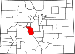
Chaffee County, Colorado Basics:


Chaffee County Colorado - Government Site

Population: 18,127
Area: 1013 square miles
County seat: Salida
Area code(s) in use: 719
Time zone: MST
High school graduate or higher: 91.3%
Bachelor's degree or higher: 33.4%
Median household income: $45,713
Persons in poverty: 9.4%
Home ownership rate: 76.0%
Mean travel time to work: 14.1 minutes


Adjacent counties:
Fremont  Gunnison  Lake  Park  Pitkin  Saguache  

Find in Colorado

Map of the Chaffee County area


Our detail map of Chaffee County shows the Chaffee County, Colorado boundary lines and other interesting items.

Places in Chaffee County, Colorado

  Airports     show all on map

Central Colorado Regional Airport, CMRS Airdrome Airport, Dodsworth Airport, Granite Heliport, Harriet Alexander Field Airport, Mount Princeton Heliport, Salida Airport, Salida Hospital Heliport

  Arches     show all on map

Aspen Arch

  Basins     show all on map

Devils Armchair, Horn Fork Basin, La Plata Basin, Mineral Basin, Missouri Basin, Silver Basin

  Buildings     show all on map

Buena Vista Correctional Complex, Buena Vista Fire Department, Buena Vista Police Department, Chaffee County Emergency Medical Service, Chaffee County Emergency Medical Services Station 1, Chaffee County Fire Protection District Station 1, Chaffee County Fire Protection District Station 15, Chaffee County Fire Protection District Station 2, Chaffee County Fire Protection District Station 3, Chaffee County Fire Protection District Station 4, Chaffee County Fire Protection District Station 5, Chaffee County Jail, Chaffee County Sheriff's Office, Chaffee County Sheriff's Office Buena Vista, Colorado Division of Wildlife Salida Service Center, Colorado Fire Camp, Colorado State Parks Arkansas Headwaters Recreation Area, Colorado State Patrol, Salida Fire Department, Salida Police Department, US Forest Service Salida Ranger District

  Canals     show all on map

Arkansas Valley Canal, Bowen Ditch, Bray Ditch, Cameron Ditch, Cottonwood Maxwell Ditch, Harrington Ditch, Helena Ditch, Johnson Ditch, Kraft Ditch, Mary Bray Ditch, McKenna Ditch, Michigan Ditch, Missouri Park Ditch, North Fork Ditch, Riverside Ditch, Salida Ditch, Silver Creek Ditch, Sunnyside Park Ditch, Trout Creek Ditch, Williams-Hamm Ditch, Williams-Hamm Diversion Ditch, Wolf and Neerland Ditch

  Cemeteries     show all on map

Centerville Cemetery, Cleora Cemetery, Fairview Cemetery, Granite Cemetery, Mount Olivet Cemetery, Winfield Cemetery, Woodlawn Cemetery

  Census     show all on map

Garfield Census Designated Place, Johnson Village Census Designated Place, Maysville Census Designated Place, Smeltertown Census Designated Place

  Churches     show all on map

Cross Roads Baptist Church

  Cliffs     show all on map

Chalk Cliffs

  Dams     show all on map

3 Elk Dam, Boss Lake Dam, Clear Creek Dam, Fooses Dam, Franz Number 1 Dam, Grays Creek Dam, North Fork Dam, O Haver Lake Dam, Twin Lakes Dam

  Falls     show all on map

Agnes Vaille Falls, Bedrock Falls, The Falls

  Flats     show all on map

Adobe Park, Bassam Park, Berrian Park, Big Grassy, Castle Park, Chubb Park, Coons Park, Davis Meadow, Harrison Flat, Hoffman Park, Kaufman Pasture, Missouri Park, Piles Pasture, Sand Park

  Forests     show all on map

San Isabel National Forest

  Gaps     show all on map

Chalk Creek Pass, Cottonwood Pass, Elkhead Pass, Hancock Pass, Monarch Pass, Old Monarch Pass, Original Monarch Pass, Poncha Pass, Trout Creek Pass, Williams Pass

  Hospitals     show all on map

Heart of the Rockies Regional Medical Center

  Lakes     show all on map

Alan Lake, Anglemeyer Lake, Baldwin Lake, Bear Lake, Billings Lake, Chalk Lake, Clohesy Lake, Crystal Lake, Dry Lake, Fooses Lake, Grizzly Lake, Hancock Lake, Hartenstein Lake, Harvard Lakes, Henschel Lake, Hunkydory Lake, Hunt Lake, Island Lake, Lake Ann, Lois Lake, Lost Lake, O'Haver Lake, Pass Creek Lake, Pomeroy Lake, Ptarmigan Lake, Rainbow Lake, Shavano Lake, Silver King Lake, Spout Lake, Tunnel Lake, Twin Lakes, Upper Hancock Lake, Upper Pomeroy Lake, Waterdog Lakes, Willis Lake

  Locales     show all on map

Angel of Shavano Campground, Beavr City, Berrian School, Blanchard Ranch, Blank Cabin, Buena Vista Square Shopping Center, Cascade Campground, Chalk Cliff Fish Hatchery, Chalk Lake Campground, Collegiate Peaks Campground, Colt Spring Campground, Cottonwood Campground, Cottonwood Lake Campground, Cottonwood Lake Picnic Ground, Garfield Campground, Goddard Ranch, Gold Bug Mine, Halfway Station, Hamilton, Hangmans Cabin, Hecla Junction, Hughes Meadow Campground, Indian Flats, Little Johns Cabin, Maxwell School, Mears Junction, Monarch (historical), Monarch Park Campground, Monarch Ski Area, Mount Princeton Campground, Mount Princeton Hot Springs (historical), Mount Shavano Hatchery, North Fork Campground, O Haver Lake Campground, Oklahoma State University Engineering Camp, Pine Creek School, Rancho Sawatch, Riverside School, Wilmot Ranch

  Mines     show all on map

Aksarben Mine, Alaska Mine, Allard Beryllium Mine, Alpha and Beta Mine, Alpine Number One Quarry, American Flag Mine, American Fluorspar Mine Company Mine, Anaconda Mine, Anna Huffman Copper Mine, Annie C Mine, April Fool Mine, Aztec Mine, Bancroft Incline Mine, Bancroft Mine, Banker Mine, Be True Mine, Bell of Granite Mine, Ben Bolts Paymaster Mine, Ben Hill Mine, Betsy Mine, Big Chief Tunnel Mine, Black Hawk Mine, Black Tiger Mine, Blakes Wonder Placer Mine, Blue Stone Mine, Bonnie Belle Mine, Bonus Extension Mine, Bowen Quarry, Brighton Mine, Buck Mine, Buckley Hill Mine, Burton Quarry, Bwlchgoch Mine, Cache Creek Mine, Calumet Iron Mine, Chaffee County Fluorspar Mine, Cinderella South Mine, Clinton Mine, Colorado Fluorspar Company Mine, Colorado Granite Quarry, Columbine Mine, Columbus Mine, Condor Mine, Copper King Mine, Crete Mine, Curly Lee Shaft Mine, Dangerfield Mine, Darling Mine, David H Shaft Mine, Delaware Mine, Delay Tunnel Mine, Desdemona Mine, Detroit Mine, Doris Ruby Group Mine, Driscoll Mine, Eclipse Mine, Eleven O'Clock Mine, Elkington Mine, Elmer McMurray Mine, Eureka Mountain Mine, Evening Star Mine, Fairplay Mine, Fairview Mine, Federal Quarry, Flora Belle Mine, Florence Extension Mine, Fortune Mine, Forward Gold Mining Company Mine, Fraction Mine, Franklin Mine, French Quarry, Futurity Mine, Garfield Mine, Garfield Quarry, Giant Eclipse Mine, Gladstone Mine, Gold Basin Mine, Gold Bottom Placer Mine, Gold Run Mine, Golden Age Mine, Golden Cache Mine, Golden Island Mine, Golden Wonder Mine, Good Hope Mine, Grand Monarch Mine, Great Monarch Mine, Gypsy Queen Mine, H and H Mine, Half Moon Mine, Hawkeye Number One Mine, Hawkeye Number Three Mine, Hawkeye Number Two Mine, Hayden Placer Mine, Herksberger Tunnel Mine, Hill Top Mine, Holdredge Mine, Holywater Mine, Homestake Mine, Independence Mine, Independent Mine, Indianapolis Mine, International Mine, Irishwood Esther Mine, Iron Chest Mine, Iron Duke Mine, Jack Rabbit Group Mine, Jasper Mine, Jewell Tunnel Mine, Joe Robesnick Mine, Josephine Mine, Josephine Number One Quarry, Josephine Quarry, Kramer Mine, Lachaw Mine, Last Chance Mine, Last Chance Prospect Mine, Last Dollar Mine, Latchaw Mine, Lehigh Mine, Lienhart Mine, Lilly Mine, Lily Mine, Lionelle Mine, Little Annie Mine, Little Annie Mine, Little Charm Mine, Little Guy Mine, Little Troy Mine, Little Wonder Mine, Longfellow Claim, Lucky Jack Mine, Lucky Mine, Lucky Mine, M and W Mine, Madonna Mine, Magenta Mine, Major Mine, Maple Leaf Mine, Mary A Claims Mine, Mary Murphy Mine, Mary Murphy Mine, Mascot Mine, Mason Mine, Matilda Mine, Middle Mountain Mine, Midwest Quarry, Mike Rabbit Mine, Mill Tunnel Mine, Missouri Boy Mine, Mizpah Mine, Monarch Lime Quarry, Monongahela Mine, Morgan Ranch Mine, Moss Flower Mine, Mound Mine, Mount Cross Granite Quarry, Mount Harvard Mine, Mount Princeton Quarry, Mountain Chief Mine, Nellie Bly Mine, New Year Mine, New York Mine, Newett Quarries, Nutmeg Mine, Ohio and Morningstar Mine, Ole Bull Mine, Oshkosh Mine, Page Mine, Paymaster Mine, Penn Nevada Dredge Mine, Pilgrim Group Mine, Pinyon Mine, Polly Number Four Mine, Pride of the West Mine, Quaker Mine, Rainbow-Eagle Bird Mine, Rarus Warrior Mine, Rock King Lode Mine, Rolla Mine, Rose Pink Quarry, Savage Placer Mine, Savilla Queen Number Two Mine, Sedalia Mine, Shamrock Mine, Shannon Last Chance Mine, Silent Friend Mine, Silver King Mine, Silver King Mine, Sitting Bull Mine, Smuggler Mine, Snowflake Lode Mine, Snowflake Number Two Mine, Song Bird Mine, Spartan Mine, Speedy Mine, Spring Mine, Springfield Mine, Stewart Mine, Stockton Mine, Stonewall Shaft Mine, Sunset Mine, Sunset Shaft Mine, Swiss Boy Dump Mine, Tamarack Mine, Tasmania Mine, Taylor Mining Syndicate Mine, The Burge Group Mine, Thirty-six-thirty Mine, Tiger Lilly Mine, Tiger Lily Mine, Tilden Mine, Tom Collins Mine, Trafalgar Mine, Trefone Tunnel Mine, Triad Mine, Trout Creek Mine View Number 2 Mine, Turret Independence Mine, Ulrich Pit, Uncle Sam Mine, Vivandiere Mine, Warner Granite Quarry, Washington Mine, White King Group Mine, Wilson Mine, Wonder Lode Mine, Yellow Bird Mine, Young America Placer Mine

  Parks     show all on map

Frantz Lake State Wildlife Area, Mount Shavano State Wildlife Area

  Pillars     show all on map

Elephant Rock, The Castles

  Populated Places     show all on map

Alpine (historical), Americus, Arbourville (historical), Babcock (historical), Belleview, Browns Canon, Buena Vista, Bullion City (historical), Centerville, Cleora, Futurity, Garfield, Granite, Greens Gulch (historical), Hancock (historical), Hartsville (historical), Hartz (historical), Hortense (historical), Iron City (historical), Jennings (historical), Johnson Village, Maysville, Nathrop (historical), Newett, Poncha Springs, Princeton, Riverside, Rockdale, Romley (historical), Saint Elmo (historical), Salida, Shavano (historical), Shirley (historical), Smeltertown, Stonewall (historical), Swan (historical), Turret, Vicksburg, Winfield

  Post Offices     show all on map

Buena Vista Post Office, Nathrop Post Office, Poncha Springs Post Office, Salida Post Office

  Ranges     show all on map

Collegiate Peaks, Sawatch Range

  Reserves     show all on map

Collegiate Peaks Wilderness

  Reservoirs     show all on map

3 Elk Reservoir, Alpine Lake, Boss Lady Reservoir, Boss Lake Reservoir, Clear Creek Reservoir, Cottonwood Lake, Fox Lake, Frantz Lake, Holywater Beaver Ponds, Ice Pond, Kroenke Lake, Lake O'Haver, North Fork Reservoir, Rainbow Lake, Ross Lake Reservoir

  Ridges     show all on map

Aspen Ridge, Bassam Ridge, Ellingwood Ridge, Gladstone Ridge, Graphite Ridge, Kaufman Ridge, Limestone Ridge, Loco Ridge, Monarch Ridge, Mountain Morning Ridge, Triad Ridge

  Schools     show all on map

Browns Canyon School, Centerville School, Gas Creek School, Longfellow School, Longfellow School, Saint Joseph School

  Springs     show all on map

Ankele Spring, Bassam Spring, Black Diamond Spring, Browns Canyon Warm Spring, Browns Grotto Warm Spring, Cottonwood Hot Springs, Cutler Spring, Hermit Springs, Hollenbeck Spring, Hortense Hot Spring, Lost Spring, Manoa Springs, Midway Spring, Mount Princeton Hot Springs, Poncha Hot Springs, Rock Spring, School Section Spring, Trout Creek Spring, Wicker Spring, Willard Spring

  Streams     show all on map

Baldwin Creek, Bassam Creek, Blackbear Creek, Browns Creek, Browns Creek, Buffalo Creek, Cache Creek, Chalk Creek, Chubb Creek, Clear Creek, Columbia Creek, Como Creek, Cottonwood Creek, Cottonwood Creek, Cree Creek, Cyclone Creek, Deep Creek, Del Monte Ditch, Denny Creek, Droz Creek, Dry Creek, Eddy Creek, Ferris Creek, Flume Creek, Fooses Creek, Four Elk Creek, Fourmile Creek, Fourmile Creek, Frenchman Creek, Gable Creek, Gas Creek, Grays Creek, Green Creek, Grey Copper Creek, Horn Fork Creek, Hughes Creek, Jennings Creek, Lake Fork, Little Browns Creek, Little Cochetopa Creek, Little Cottonwood Creek, Little Fourmile Creek, Lost Creek, Maxwell Creek, McClure Creek, McCoy Creek, McFadden Creek, Mercury Creek, Merriam Creek, Middle Cottonwood Creek, Middle Cottonwood Creek, Middle Fork South Arkansas River, Mineral Creek, Morris Creek, Morrison Creek, Murry Ditch, North Cottonwood Creek, North Fooses Creek, North Fork Chalk Creek, North Fork Clear Creek, North Fork Denny Creek, North Fork Middle Cottonwood Creek, North Fork Sevenmile Creek, North Fork South Arkansas River, Osbourne Creek, Pass Creek, Pine Creek, Pioneer Ditch, Placer Creek, Poncha Creek, Powell Creek, Ptarmigan Creek, Red Deer Creek, Redman Creek, Rock Creek, Rough and Tumbling Creek, Sand Creek, Sevenmile Creek, Silver Creek, Silver Prince Creek, South Arkansas River, South Cottonwood Creek, South Fooses Creek, South Fork Clear Creek, South Fork Lake Creek, South Fork Sevenmile Creek, South Pine Creek, South Sand Creek, Spruce Creek, Squaw Creek, Stumpy Creek, Thompson Creek, Three Elk Creek, Threemile Creek, Trout Creek, Ute Creek, Williams Hamm Ditch, Willow Creek, Woodchopper Creek

  Summits     show all on map

Bald Mountain, Bald Mountain, Banana Mountain, Birthday Peak, Boulder Mountain, Browns Peak, Calico Mountain, Calumet Mountain, Carbonate Mountain, Castle Rock, Chipeta Mountain, Chrysolite Mountain, Cleveland Mountain, Creep Mountain, Cronin Peak, Cross Mountain, Cyclone Mountain, East Buffalo Peak, Emerald Peak, Ervin Peak, Granite Mountain, Grizzly Mountain, Huron Peak, Iowa Peak, Jones Mountain, Jones Peak, La Plata Peak, Lake Hill, Lost Mountain, Marmot Peak, Methodist Mountain, Middle Mountain, Middle Mountain, Midland Hill, Missouri Hill, Missouri Mountain, Mount Aetna, Mount Antero, Mount Arps, Mount Belford, Mount Blaurock, Mount Chapman, Mount Columbia, Mount Harvard, Mount Helmers, Mount Hope, Mount Mamma, Mount Oxford, Mount Peck, Mount Princeton, Mount Shavano, Mount White, Mount Yale, Ouray Peak, Pahlone Peak, Pecks Peak, Peel Point, Pomeroy Mountain, Poncha Mountain, Quail Mountain, Rick Mountain, Rinker Peak, Ruby Mountain, Sawmill Hill, Sewanee Peak, Sheep Mountain, Sugarloaf Mountain, Syncline Hill, Tabeguache Peak, Taylor Mountain, Tenderfoot Hill, The Crater, The Reef, The Three Apostles, Turner Peak, Twin Peaks, Van Wirt Mountain, Virginia Peak, Waverly Mountain, West Buffalo Peak, Winfield Peak

  Towers     show all on map

KDMN-AM (Buena Vista), KVRH-AM (Salida), KVRH-FM (Salida), WVRH Radio Tower

  Trails     show all on map

Browns Creek Trail, Fooses Creek Trail, Fourmile Creek - Buffalo Meadows Trail, Harvard Trail, Horn Fork Trail, Lenhardy Cutoff, Midland Bike Trail, Pine Creek Trail, South Pine Creek Trail, Texas Creek Trail, Wapaca Trail

  Tunnels     show all on map

Old Alpine Tunnel (historical)

  Valleys     show all on map

Arnold Gulch, Avalanche Gulch, Bails Gulch, Bald Mountain Gulch, Baldwin Gulch, Belford Gulch, Big Sandy Draw, Blank Gulch, Browns Canyon, Camp Rock Gulch, Cascade Canyon, Castle Rock Gulch, Cat Gulch, Cedar Gulch, Cemetery Gulch, Charcoal Gulch, Chinaman Gulch, Coal Camp Canyon, Coal Kiln Gulch, Columbia Gulch, Columbine Gulch, Columbus Gulch, Cottonwood Gulch, Crater Gulch, Cutler Gulch, Daley Gulch, Dead Can Gulch, Dead Goat Gulch, Dead Horse Gulch, Deadman Gulch, Deer Canyon, Delaney Gulch, Denny Gulch, Droney Gulch, Dry Columbia Gulch, Dry Lake Gulch, East Castle Rock Gulch, Futurity Gulch, Grassy Gulch, Green Gulch, Green Timber Gulch, Grizzly Gulch, Grouse Canyon, Harrington Gulch, Harris Gulch, Hawkinsville Gulch, Hayden Gulch, Hewitts Gulch, Hop Gulch, Hope Gulch, Hunkydory Gulch, Hunter Gulch, Iwoa Gulch, Jonesy Gulch, King Gulch, Lake Gulch, Langhoff Gulch, Little Bull Gulch, Little Willis Gulch, Loggie Gulch, Longfellow Gulch, Longs Gulch, Lost Canyon, Lulu Gulch, Marble Quarry Gulch, McGee Gulch, McNasser Gulch, Mill Gulch, Missouri Gulch, Morgans Gulch, Mushroom Gulch, Peekaboo Gulch, Pomeroy Gulch, Poplar Gulch, Porphyry Gulch, Railroad Gulch, Raspberry Gulch, Robey Gulch, Sand Gulch, Sawmill Gulch, Sayres Gulch, Sheep Canyon, Sheep Gulch, Sheephead Gulch, Shields Gulch, Short Gulch, Silverheels Gulch, Siverheel Gulch, Spring Gulch, Spruce Gulch, Stafford Gulch, Sweetwater Gulch, Taylor Gulch, Tie Gulch, Tie Gulch, Tunnel Gulch, Waverly Gulch, Weldon Gulch, Weldon Gulch, West Columbine Gulch, Wildcat Gulch,

Chaffee County, Colorado Population By Race (2012 estimate)

RacePopulation
WhiteChaffee County White population 17,18417,184  
BlackChaffee County Black population 308308
MixedChaffee County Mixed population 254253
AsianChaffee County Asian population 127126
Hawaiian & Pacific IslanderChaffee County Hawaiian & Pacific Islander population 1818

Additional population tables :
State population table
Colorado population by county