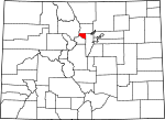
Gilpin County, Colorado Basics:


Gilpin County Colorado - Government Site

Population: 5,497
Area: 150 square miles
County seat: Central City
Area code(s) in use: 303
Time zone: MST
High school graduate or higher: 94.2%
Bachelor's degree or higher: 30.1%
Median household income: $62,286
Persons in poverty: 10.3%
Home ownership rate: 75.5%
Mean travel time to work: 32.9 minutes


Adjacent counties:
Boulder  Clear Creek  Grand  Jefferson  

Find in Colorado

Map of the Gilpin County area


Our detail map of Gilpin County shows the Gilpin County, Colorado boundary lines and other interesting items.

Places in Gilpin County, Colorado

  Airports     show all on map

Athanasiou Valley Airport

  Buildings     show all on map

Black Hawk Fire Department, Black Hawk Police Department, Central City Fire Department Station 1, Central City Fire Department Station 2, Central City Police Department, Colrado State Patrol Gilpin County Gaming Post, Gilpin Ambulance Authority Black Hawk, Gilpin County Community Center, Gilpin County Justice Center - Courthouse, Gilpin County Library, Gilpin County School, Gilpin County Sheriff's Office, Timberline Fire / Rescue Station 2, Timberline Fire / Rescue Station 3, Timberline Fire / Rescue Station 6, Timberline Fire Protection District Station 5, Timberline Fire Protection District Station 7

  Cemeteries     show all on map

Bald Mountain Cemetery, Catholic Cemetery, Central City Cemetery, Dory Hill Cemetery, Foresters Cemetery, Independent Order of Oddfellows Cemetery, Knights of Pythias Cemetery, Masonic Cemetery, Missouri City Cemetery, Red Men Lodge Cemetery, Rocky Mountain Independent Order of Oddfellows Lodge Number 2 Cemetery, Russell Gulch Cemetery

  Census     show all on map

Rollinsville Census Designated Place

  Dams     show all on map

Braecher Ranch Dam, Camp Shoshoni Dam, Mammoth Creek Dam

  Falls     show all on map

Missouri Falls

  Flats     show all on map

Boulder Park, Elk Park, Frazer Meadow, Kings Flat, Pecks Flat

  Gaps     show all on map

Rogers Pass

  Lakes     show all on map

Arapaho Lakes, Clayton Lake, Crater Lakes, Dory Lake, Forest Lakes, Heart Lake, Iceberg Lakes, James Peak Lake, Little Echo Lake, Missouri Lake, Pisgah Lake, Rogers Pass Lake, Thorn Lake

  Locales     show all on map

Bootleg Bottom Picnic Area, Cold Springs Campground, Fritz Peak Observatory, Jumbo Mountain Picnic Area, Ole Barn Knoll Picnic Area, Pickle Gulch Campground, Ralston Roost Picnic Area, Reverends Ridge Campground, Rimrock Campground, Rollinsville Work Center, Round the Bend Picnic Area

  Mines     show all on map

Adelbert Lode Mine, After Supper Mine, Ajax Mica Mine, Alps Mine, Alps-Olympia Mine, Amanda Mine, Amazon Mine, American Girl Mine, Anchor Mine, Andrew Lode Mine, Ashtabula Mine, Aurelia Mine, Ayres Shaft Mine, Baltimore Mine, Bangur Shaft Mine, Banta Hill Mine, Barnes Mine, Bates Mine, Becker-Bates Mine, Beecher Mine, Belfast Mine, Belmont Mine, Bennett Mine, Bezant Mine, Big Bertha Mine, Black Hills Shaft, Black Hills Tunnel, Blackhawk Placer Mine, Bobtail Mine, Bonanza Mine, Boodle Mine, Boss Mine, Boss Mine, Brooklyn Mine, Buell Shaft Mine, Bullion Mine, Burlington-Iowa Mine Group, Burroughs Mine, Caledonia Lode Mine, California Mine, Camp Grove Mine, Carr Mine, Casto Mine, Center Tunnel Mine, Chain of Mines, Champion Mine, Champion Mines, Charcoal Charlie Mine, Chase Mine, Chemung-Belmont Mine, Cherokee Mine, Cherub Lode Mine, Chihuahua Tungsten Mine, Christina Mine, Claudia Lode Mine, Climax Mine, Clinkenbeard Mine, Coeur d'Alene Mine, Colfax Mine, Columbia Mine, Concrete Mine, Congress Lode, Cook Mine, Corydon Mine, Couch Mine, Crawford Shaft Mine, Cuckoo Shaft Mine, Curtis Lode Mine, Cyclops Mine, Delmonico Mine, Denango County Mine, Diamond Bill Mine, Diamond Joe Mine, Dolores Mine, Dory Hill Mine, Downie Mine, Druid Mine, Dyke Mine, E and H Jelly Roll Mine, Early Bird Mine, East Calhoun Mine, East Pewabic Mine, East Williams Mine, Edith Lode Mine, Egyptian Mine, Eldorado Mine, Elizabeth Mine, Ellis Lode Mine, English America Lode Mine, Essex Mine, Evergreen Mine, F F F Mine, Fagan Mine, Fannie Mine, Federal Mine, Fish Mine, Fisk Mine, Forfar Mine, Francis Mine, Freedom Mine, Freiburg Mine, Gallup Mine, Garden Mine, Garden Mine, Gasten Mine, Geiger Mine, German Mine, Gettysburg Mine, Gettysburg Mine, Gilpin Eureka Mine, Gilpin Mine, Gladstone Mine, Golconda Mine, Gold Bug Mine, Gold Chief Mine, Gold Collar Mine, Gold Cup Mine, Gold Dirt Mine, Gold Medal Mine, Gold Quartz Mine, Gold Reserve Mine, Gold Spring Group Mine, Golden Cycle Mine, Golden Flint Mine, Golden Rod Mine, Golden Slipper Mine, Golden Sun Tunnel, Golder-Passarella Claims Mine, Grace Mine, Grand Army Mine, Grand Union Mine, Grant Number Ten Mine, Grant Number Twelve Mine, Gregory Mine, Harker Shaft Mine, Haywood Mine, Hazeline Mine, Hillhouse Mine, Hope Mine, Hubert Mine, Huckleberry Mine, Hunky Dory Mine, Hunter Mine, Illinois Mine, Incidental Mine, Indiana Mine, Ingram Mine, Iowa Girl Lode Mine, Jack Rabbit Mine, Jackson Mine, Jess Lode Mine, Johnson Mine, Jones Mine, Jumbo Mine, Justice Mine, Kansas Mine, Kelleher Mine, Kent County Mine, Kerry Chief Mine, Keystone Mine, King Mine, Kirk Mine, Klence Fall Mine, Kokomo Mine, La Cross Mine, Leavenworth Mine, Linda Number One Mine, Linda Number Two Mine, Little Annie Mine, Little Colonial Mine, Little Eola Mine, Little Johnny Mine, Little Mary Mine, Little Melvin Lode Mine, Little Rebel Mine, Lode Star Mine, London Mine, Lone Star Mine, Lost Dollar Mine, Lost Lode Mine, Lotus Mine, Mackey Mine, Macky Burroughs Shaft Mine, Main Mine, Mammoth Mine, Manchester Mine, Mareau Mine, Margaret Olive Mine, Marshall Placer, Mary Miller Mine, Mattie May Mine, McAllister Mine, Meeker Mine, Melett Mine, Melrose Mine, Melvin Tungsten Mine, Minnesota Mine, Missouri Mine, Mollie Lode Mine, Moon Gulch Mine, Moose Mine, Morning Snow Mine, Mountain Monarch Mine, Nation Mine, Nemeha-Cotton Mine, Nevada Gulch Placer Mine, Newhouse Mine, Newkirk Mine, Newport Mine, Notaway East Mine, Nugget Mine, Nye-Matthews Mine, O K Mine, Old Kentucky Mine, Old Town Mine, Old Town Shaft Mine, Ontario Mine, Ophir Mine, Orandake Mine, Otte Mine, Pease Mine, Penobscot Mine, Perigo Mines, Perseverance Mine, Pettibone Mine, Petunia Mine, Philadelphia Mine, Phoenix Mine, Pine Cone Mine, Pittsburgh Mine, Plateau Mine, Pocahontas Mine, Pozo Mine, Priscilla Group Claim Mine, Quaker Mine, Quartz Hill Tunnel Mine, Queen Bee Mine, Quincy Bart Atlantic Mine, Quindaro Mine, R P Ranney Mine, Rara Avis Mine, Reider Mine, Reliance Lode Mine, Richardson Mine, Robert Emmett Mine, Roderick Mine, Rolls County Mine, Root Ranch Lease Mine, Royal Keith Lode Mine, Rudolph Mine, Russell Mine, San Juan Mine, Sans Souci Mine, Saratoga Mine, Scandia Mine, Schultz Wonder Mine, Sea Bird Mine, Shammrock Mine, Shamrock Mine, Shamrock Mine, Silent Friend Mine, Silver Dollar Mine, Sixteen-to-One Mine, Smith Mine, Smuggler Mine, Snowden Mine, Spanish Bar Group Mine, Specie Mine, Spread Eagle Mine, Springdale Mine, Spur-Daisy Group Mine, Star Mine, Stewart Mine, Strayer Corner Mine, Success-Meeker Mine, Sunnyside Tunnel Mine, Tacoma Tunnel Mine, Telegraph Mine, The Glory Hole, Tip Top Mine, Topeka Mine, Tucker Number One Mine, Twin Sisters Mine, Two Brothers Tunnel Mine, Two Sisters Group Mine, Two-Forty Mine, Ute Gold Properties Mine, Vendome Mine, Victoria Mine, War Dance Mine, War Eagle Mine, Wautauga Shaft Mine, West Notaway Mine, Whiting Mine, Widow Woman Vein Mine, Wolftone Mine, Wolverine Mine, Wood Mine, Wyandotte Mine

  Parks     show all on map

Central City-Balck Hawk Historic District, Golden Gate Canyon State Park

  Pillars     show all on map

Castle Rock, Queens Chair, Ralston Roost

  Populated Places     show all on map

American City (historical), Baltimore (historical), Black Hawk, Central City, Cottonwood, East Portal, Gilpin, Lincoln Hills, Nevadaville, Nugget, Pactolus, Perigo (historical), Phoenix (historical), Pinecliffe, Rollinsville, Russell Gulch, Smith Hill, Tolland, Wideawake (historical)

  Post Offices     show all on map

Black Hawk Main Post Office, Central City Post Office, Rollinsville Post Office, Tolland Post Office (historical)

  Reservoirs     show all on map

Braecher Lake, Braecher Ranch Reservoir, Camp Shoshoni Reservoir, Karel Park Lake, Kriley Pond, Los Lagos Reservoirs Number 1, Los Lagos Reservoirs Number 2, Los Lagos Reservoirs Number 3, Mammoth Creek Reservoir, Manchester Lake, Slough Pond, Snowline Lake, Teller Lake

  Ridges     show all on map

Baltimore Ridge, Promontory Ridge

  Streams     show all on map

Antelope Creek, Arapaho Creek, Colorado Creek, Elk Creek, Ellsworth Creek, Jenny Creek, Lake Fork, Missouri Creek, Montana Creek, Mosquito Creek, North Clear Creek, Nott Creek, Pine Creek, Ralston Creek, Silver Creek, South Beaver Creek, South Boulder Creek

  Summits     show all on map

Alps Hill, Arizona Mountain, Aunt Clara Brown Hill, Banta Hill, Bates Hill, Blackhawk Peak, Bobtail Hill, Buckeye Mountain, California Mountain, Central Hill, Colorado Mountain, Dakota Hill, Dory Hill, Ely Hill, Fairburn Mountain, Fritz Peak, Gregory Hill, Haystack Mountain, Idaho Hill, Jumbo Mountain, Justice Hill, Kingston Peak, Mammoth Hill, Maryland Mountain, Michigan Hill, Miramonte Mountain, Montana Mountain, Mount Thomas, Nebraska Hill, Nevada Hill, Oregon Hill, Panorama Point, Pewabic Mountain, Pile Hill, Quartz Hill, Signal Hill, Silver Hill, Smith Hill, Starr Peak, Thorodin Mountain, Tremont Mountain, Utah Hill, Winnebago Hill, Yankee Hill

  Trails     show all on map

Bolling Gulch Trail, James Peak Lake Trail, Mount Thorodin Trail, South Boulder Creek Trail

  Valleys     show all on map

Arbuckle Gulch, Baker Gulch, Black Canyon, Black Gulch, Boiling Gulch, Broomfield Gulch, Burns Gulch, Chase Gulch, Cottonwood Gulch, Davenport Gulch, Dude Hole, Elkhorn Gulch, Eureka Gulch, Fountain Gulch, Fourmile Gulch, Freeman Gulch, Gamble Gulch, Gibson Gulch, Gregory Gulch, Hangman Gulch, Illinois Gulch, Jelly Roll Gulch, Jenny Lind Gulch, Lake Gulch, Leavenworth Gulch, Lump Gulch, Macy Gulch, Mammoth Gulch, Miners Gulch, Missouri Canyon, Moon Gulch, Nevada Gulch, Packard Gulch, Pecks Gulch, Pickle Gulch, Pleasant Valley, Prosser Gulch, Quartz Valley, Russell Gulch, Silver Gulch, Smith Gulch, Smith Hill Gulch, South Willis Gulch, Spring Gulch, Stewart Gulch, Travis Gulch, Whites Gulch, Willis Gulch,

Gilpin County, Colorado Population By Race (2012 estimate)

RacePopulation
WhiteGilpin County White population 5,2115,211  
MixedGilpin County Mixed population 9393
AsianGilpin County Asian population 7776
American IndianGilpin County American Indian population 6060
BlackGilpin County Black population 3838
Hawaiian & Pacific IslanderGilpin County Hawaiian & Pacific Islander population 1110

Additional population tables :
State population table
Colorado population by county