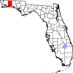
Okaloosa County, Florida Basics:


Okaloosa County Florida - Government Site

Population: 190,232
Area: 930 square miles
County seat: Crestview
Area code(s) in use: 850
Time zone: CST
High school graduate or higher: 91.2%
Bachelor's degree or higher: 27.2%
Median household income: $54,118
Persons in poverty: 12.5%
Home ownership rate: 66.3%
Mean travel time to work: 22.8 minutes


Adjacent counties:
Covington (AL)  Escambia (AL)  Santa Rosa  Walton  

Find in Florida

Map of the Okaloosa County area


Our detail map of Okaloosa County shows the Okaloosa County, Florida boundary lines and other interesting items.

Places in Okaloosa County, Florida

  Airports     show all on map

Bob Sikes Airport, Destin-Fort Walton Beach Airport, Dotson Airport, Duke Field (Eglin AF Aux Nr 3) Airport, Eglin Air Force Base, Eglin Test Site B6 Airport, Five Oaks Estate Airport, Fort Walton Beach Medical Center Heliport, Hurlburt Field Airport, Lonesome Pines Airport, North Okaloosa Medical Center Heliport, Ruckel Airport, Sky Ranch Airport, Triple B Airpark, Yellow River Airstrip

  Bays     show all on map

Boggy Bayou, Cinco Bayou, Destin Harbor, Dons Bayou, Garmier Bayou, Hand Cove, Joes Bayou, John Bayou, Jones Bayou, Marler Bayou, Poquito Bayou, Rocky Bayou, Sarah Ann Bayou, Shirk Bayou, Sunset Cove, Toms Bayou, Ward Cove, Weekley Bayou

  Bridges     show all on map

Brooks Bridge, C G Melgs Bridge, Cotton Bridge, Hayward Hayes Overpass, Kennedy Bridge, Peaden Bridge, Red Oak Bridge

  Buildings     show all on map

Almarante Fire District, Baker Fire District, Blackman Volunteer Fire Department, Crestview Fire Department, Crestview Fire Department Station 5, Destin Fire Control District Headquarters Station 9, Destin Fire Control District Station 10, Dorcas Fire District Station 41, Dorcas Fire District Station 42, East Niceville Fire District, Eglin Air Force Base Fire Station 1, Eglin Air Force Base Fire Station 2, Eglin Air Force Base Fire Station 3, Eglin Air Force Base Fire Station Camp Rudder, Eglin Air Force Base Fire Station Duke Field 3, Eglin Air Force Base Fire Station Hurlburt Field, Florosa Fire Control District, Fort Walton Beach Fire Department Station 6, Fort Walton Beach Fire Department Station 7, Fort Walton Beach Public Library, Gulf Coast Treatment Center, Holt Volunteer Fire District, Laurel Hill Volunteer Fire Department, Mary Esther Fire Department, Niceville Fire Department, North Bay Fire District, North Okaloosa Fire Department Station 82, North Okaloosa Fire Department Station 83, North Okaloosa Fire Department Station 84, North Okaloosa Fire District Station 87, Ocean City - Wright Fire District Station 1, Ocean City - Wright Fire District Station 2, Ocean City - Wright Fire District Station 3, Okaloosa County Emergency Medical Services, Okaloosa County Emergency Medical Services Station 1, Okaloosa County Emergency Medical Services Station 10, Okaloosa County Emergency Medical Services Station 2, Okaloosa County Emergency Medical Services Station 3, Okaloosa County Emergency Medical Services Station 4, Okaloosa County Emergency Medical Services Station 5, Okaloosa County Emergency Medical Services Station 6, Okaloosa County Emergency Medical Services Station 8, Okaloosa County Emergency Medical Services Station 9, Okaloosa Island Fire District, Valparaiso Volunteer Fire Department

  Capes     show all on map

Black Point, Boggy Point, Buccaroo Point, Clay Point, Cobbs Point, Lasater Point, Manatee Point, Moreno Point, Nelson Point, Norreigo Point, Paradise Point, Piney Point, Shirk Point, Smack Point, Stake Point, Upper Pritchard Long Point, White Point

  Cemeteries     show all on map

Beal Cemetery, Beulah Cemetery, Carr Cemetery, Clary Cemetery, Cobb Cemetery, Early Cemetery, Ebenezer Cemetery, Griffith Cemetery, Hart Cemetery, Hobbs Cemetery, Holt Cemetery, Live Oak Cemetery, Mount Olive Cemetery, Mount Zion Cemetery, New Canoe Cemetery, Old Dorcas Cemetery, Reeder Cemetery, Rock Hill Cemetery, Rock Hill Cemetery, Rocky Cemetery, Stewart Cemetery, Sweeney Cemetery

  Census     show all on map

Eglin Air Force Base Census Designated Place, Lake Lorraine Census Designated Place, Ocean City Census Designated Place, Wright Census Designated Place

  Channels     show all on map

East Pass, Griffith Ferry Stretch, North Channel, The Narrows

  Churches     show all on map

Almerant Church, Antioch Church, Beaver Creek Church, Bethel Church, Bethel Church, Bullard Church, Campton Church, Canaan Church, Clear Springs Church, Ebenezer Church, Friendship Church, Golan Church, Good Hope Church, Hester Church, Holy Trinity Church, Light House Church, Lighthouse Church, Live Oak Church, Magnolia Church, Mount Zion Church, New Bethany Church, New Bethel Church, Oakland Church, Old Ebenezer Church, Olive Branch Church, Parkway Church, Pilgrims Rest Church, Pinecrest Community Church, Pleasant Hill Church, Pyron Spring Chapel, Red Oak Church, Rock Hill Church, Shady Grove Church, Travelers Rest Church, Welcome Church, Yellow River Church

  Cliffs     show all on map

Metts Bluff, Moreno Point, Rattlesnake Bluff, Tucker Bluff, Wilkinson Bluff, Yellow Bluff

  Flats     show all on map

Spencer Flats

  Hospitals     show all on map

Crestview Community Hospital, Fort Walton Beach Hospital Extended Care, Fort Walton Beach Medical Center, HSA Gulf Coast Hospital, North Okaloosa Medical Center, Twin Cities Hospital, United States Air Force Eglin Regional Hospital

  Islands     show all on map

Hudson Island

  Lakes     show all on map

A A Hilton Pond, A J Kennedy Pond One, A J Kennedy Pond Two, Allison Pond, Alva Davidson Pond, Bass Lake, Bens Lake, Blue Pond, Brooks Pond, Brown Pond, Carver Pond, Clyde Reese Pond, Crain Pond, Danley Pond, Dixon Lake, Duck Pond, Dugan Pond, E C Younghood Pond, Eden Lake, Flowers Pond, Four Prong Lake, Grass Lake, Green Pond, Green Ponds, Guest Lake, Holley Pond, John Stafford Pond One, John Stafford Pond Two, Kemmons Pond, Kendrick Pond, Kepner Pond, Lake Earl, Lake Ella, Lake Lorraine, Laurence Staff Pond, Lost Boy Pond, Martin Pond, Martins Mill Pond, Metts Pond, O G Steele Pond, Perry Reeves Pond, Pine Bluff Lake, Pine Lake, Pippin Lake, Pirate Cove, Pocosin Pond, Prairie Ponds, Rainbow Lake, Sap Ponds, Sigler Lake, Timber Lake, Walton Pond, Ward Bay, Wright Lake

  Locales     show all on map

Bayou Plaza, Bel-Air Shopping Center, Beltway Shopping Center, Bluff Landing, Camp Pinchot, Carr Landing, Choctawatchee Bay Entrance, Crestview Country Club, Crestview Plaza, Eastgate North Shopping Center, Fauck Ferry, Ferry Pass Plaza, Fort Walton Square, Gin Hole Landing, Mariner Outlet Mall, Mariner Plaza, Mason Landing, Meritt Landing, Miracle Mart, Moreno Plaza, Northgate Shopping Center, Palm Plaza, Palmetto Plaza, Parkway Plaza, Shoreline Village Mall, Sun Plaza, Sweetgum Landing, The Shores Shopping Center, Towncrest Shopping Center, Village Center

  Military     show all on map

Eglin Air Force Base, Hurlburt Field

  Parks     show all on map

Clearwater Park, Eglin Wildlife Management Area, Fort Walton Beach Park, Fort Walton Mound, Fred Gannon Rocky Bayou State Recreation Area, Henderson Beach State Recreation Area, Jet Stadium, Rocky Bayou State Park Aquatic Preserve, Twin Hills Park

  Populated Places     show all on map

Auburn, Baker, Beaver Creek, Blackman, Campton, Cannon Town, Cinco Bayou, Clear Springs, Crestview, Dana Point, Dana Pointe, Deerland, Destin, Dorcas, Eglin Village, Escambia Farms, Fort Walton Beach, Galliver, Garden City, Garnier, Good Hope, Harris, Holt, Kellys Mill, Killingsworth Crossroads, Lake Lorraine, Laurel Hill, Longwood, Mary Esther, Milligan, Niceville, Nubbin Ridge, Oak Grove, Ocean City, Okaloo, Peaden, Postil, Rock Creek, Seminole, Shalimar, Silver Springs, Svea, Valparaiso, Wright, Wynnehaven Beach

  Reservoirs     show all on map

Anderson Pond, Brandt Pond, Corkins Lake, Cypress Pond, Faircloth Lakes, Hazelwood Pond, Hurricane Lake, Jack Lake, Karick Lake, Lake Clyde, Lake Kennedy, Lake Vivian, Lower Memorial Lake, Martin Lakes, Plew Lake, Puddin Head Lake, Roberts Lake, Silver Lake, Trout Lake, Upper Memorial Lake

  Schools     show all on map

Addie R Lewis Junior High School, Baker School, Bay Area Vocational-Technical School, C W Ruckel Junior High School, Cherokee School, Choctawhatchee High School, Crestview Senior High School, Crestview Vocational-Technical Center, Destin School, Edge School, Edwins School, Elliott Point School, Florosa School, Fort Walton Beach High School, Kenwood School, Laurel Hill School, Longwood Elementary School, Mary Esther Elementary School, Max Bruner, Junior, Junior High School, Meigs Junior High School, New Heights School, Niceville Senior High School, Northwood School, Oak Hill School, Oakland Heights School, Ocean City Elementary School, Okaloosa-Watson College, Plew School, Pryor Junior High School, Richbourg Junior High School, Saint Marys School, Shalimar School, Sikes School, Silver Sands School, Southside School, Valparaiso Elementary School, Wright School

  Springs     show all on map

Blue Spring

  Streams     show all on map

Adams Mill Creek, Alligator Branch, Alligator Creek, Anderson Branch, Baggett Creek, Bailey Branch, Bandy Branch, Barrel Branch, Bass Branch, Bay Branch, Bear Branch, Bear Creek, Bear Creek, Bear Creek, Beaver Branch, Bee Branch, Bee Branch, Beech Branch, Bends Creek, Bens Creek, Bethel Spring Branch, Big Branch, Big Creek, Big Fork, Big Horse Creek, Big Horse Creek, Black Branch, Blue Spring Creek, Boggy Hollow Creek, Bolton Branch, Bone Creek, Bridge Branch, Buck Branch, Buckhannon Branch, Bull Branch, Bull Creek, Bull Pen Branch, Camp Creek, Campbells Mill Creek, Canoe Creek, Carr Branch, Carr Spring Branch, Carroll Creek, Cherry Branch, Chula Vista Bayou, Clear Creek, Cobb Branch, Coon Head, Cotton Creek, Cow Pen Branch, Cypress Pond Branch, Davis Mill Creek, Deadfall Creek, Deerland Branch, Dog Creek, Dry Branch, Dry Ford Branch, Early Branch, East Branch Mare Creek, East Dog Creek, Fort Kirkland Branch, Fox Head Branch, Garnier Creek, Gopher Creek, Gourd Bay, Green Branch, Gully Branch, Gully Branch, Gum Springs Branch, Gunn Creek, Hannah Branch, Henderson Branch, Hog Pen Branch, Hogpen Branch, Holley Creek, Honey Creek, Horse Branch, Horsehead Creek, Hurricane Creek, Indian Bayou, Indian Branch, Island Branch, Jack Branch, Jack Branch, Juniper Creek, Juniper Creek, Juniper Creek, Kennedy Branch, King Branch, Kohler Bayou, Lightwood Knot Creek, Line Branch, Little Branch Beaver Creek, Little Escambia Creek, Little Horse Creek, Little Rocky Creek, Little Trout Creek, Live Oak Creek, Long Branch, Long Branch, Long Branch, Long Creek, Long Creek, Long Creek, Mack Branch, Malone Creek, Mare Creek, Mathison Creek, Metts Creek, Middle Creek, Middle Creek, Middle Creek, Middle Rocky Creek, Mill Branch, Mill Creek, Mill Creek, Mill Creek, Mill Creek, Milligan Creek, Moccasin Branch, Moores Mill Creek, Muddy Branch, Murder Creek, Narrows Creek, Ninemile Creek, Oak Creek, Olive Branch, Painter Branch, Panther Creek, Parrish Creek, Pearl Creek, Penny Creek, Pine Log Creek, Pinelog Creek, Piney Woods Creek, Point Lookout Creek, Polley Creek, Pond Creek, Poplar Head Branch, Poverty Creek, Powell Spring Branch, Prairie Creek, Pump Branch, Pyron Spring Branch, Ramer Creek, Red Wash Branch, Red Wash Branch, Red Wash Branch, Reedy Branch, Reedy Creek, Rock Creek, Rogue Creek, Rum Still Branch, Sanders Branch, Sarah Ann Branch, Shaw Still Branch, Shoal River, Silver Creek, Silver Creek, Smith Branch, Spring Branch, Steves Wash Branch, Still Branch, Surveyor Creek, Swift Creek, Tan Vat Branch, Tenmile Creek, Threemile Branch, Tidwell Mill Creek, Titi Creek, Toms Creek, Trammel Creek, Trawick Creek, Turkey Creek, Turkey Creek, Turkey Gobbler Creek, Turkey Hen Creek, Turtle Creek, Twin Creek, Tyner Branch, Ward Mill Creek, West Branch Lightwood Knot Creek, West Branch Mare Creek, West Dog Creek, Wilkinson Creek, Williams Branch

  Swamps     show all on map

Copeland Bay, McCloud Bay, Pennywinkle Bay, Tyner Bay, Watson Bay

  Towers     show all on map

Ramer Lookout Tower, Sand Hill Lookout Tower, WAAZ-FM (Crestview), WAAZ-FM (Crestview), WAWD-TV (Fort Walton Beach), WAWD-TV (Fort Walton Beach), WBZR-AM (Destin), WCNU-AM (Crestview), WFGX-TV (Fort Walton Beach), WFSH-AM (Valparaiso-Niceville), WFTW-AM (Fort Walton Beach), WJSB-AM (Crestview), WJSB-AM (Crestview), WJUS-FM (Fort Walton Beach), WJUS-FM (Fort Walton Beach), WKSM-FM (Fort Walton Beach), WMMK-FM (Destin), WNUE, WNUE-AM (Fort Walton Beach), WPSM-FM (Fort Walton Beach), WTJT-FM (Baker), WTJT-FM (Crestview), WYZB-FM (Mary Esther)

  Valleys     show all on map

Deep Head, Deer Head,

Okaloosa County, Florida Population By Race (2012 estimate)

RacePopulation
WhiteOkaloosa County White population 156,561156,560  
BlackOkaloosa County Black population 18,64318,642
MixedOkaloosa County Mixed population 7,2297,228
AsianOkaloosa County Asian population 5,8975,897
American IndianOkaloosa County American Indian population 1,3321,331
Hawaiian & Pacific IslanderOkaloosa County Hawaiian & Pacific Islander population 380380

Additional population tables :
State population table
Florida population by county