St. Johns County, Florida Basics:


St. Johns County Florida - Government Site

Population: 202,328
Area: 601 square miles
County seat: Saint Augustine
Area code(s) in use: 904
Time zone: EST
High school graduate or higher: 92.7%
Bachelor's degree or higher: 40.7%
Median household income: $64,346
Persons in poverty: 9.8%
Home ownership rate: 76.7%
Mean travel time to work: 25.4 minutes

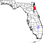
Adjacent counties:
Clay  Duval  Flagler  Putnam  

Find in Florida

Map of the St. Johns County area


Our detail map of St. Johns County shows the St. Johns County, Florida boundary lines and other interesting items.

Places in St. Johns County, Florida

  Airports     show all on map

Bartram Farms Air Park, Byrd Air Field, Earle Airpark, Flagler Hospital Heliport, Frontier Airport, Hutson Airfield, Potato Blossom Airport, Revels Strip, St Augustine Airport, Sunshine Farms Airport, Tater Farms Strip Airport, Tocoi Airport

  Bays     show all on map

Colee Cove, Colee Cove, Florence Cove, Florence Cove, Hallowes Cove, Ibis Cove, Little Florence Cove, Little Florence Cove, Mud Alley, Palmo Cove, Palmo Cove, Solano Cove

  Beaches     show all on map

Butler Beach

  Bends     show all on map

Devils Elbow

  Bridges     show all on map

Bridge of Lions, Claude Varne Bridge, Mickler Oconnel Bridge, Palm Valley Bridge, Shands Bridge, Vilano Beach Bridge

  Buildings     show all on map

Ernest Hemingway House, Florida Lost Tribes Museum, Florida's Oldest House Museum, Gonzales-Alverez House, Government House Museum, Hotel Ponce de Leon (historical), Lightner Museum, Louise Wise Library - Flagler College, Old Saint Augustine Village Museum, Oldest Store Museum, Racy Point Post Light (historical), Reddie Point Post Light (historical), Saint Augustine Beach Police Department, Saint Augustine Fire Department, Saint Augustine Fire Department Island Station, Saint Augustine Historical Society Library, Saint Augustine Police Department, Saint Augustine Visitor and Convention Bureau Johns Branch, Saint Johns County Fire Rescue Station 1 Palm Valley, Saint Johns County Fire Rescue Station 10 Ponte Vedra, Saint Johns County Fire Rescue Station 11 Saint Augustine Shores, Saint Johns County Fire Rescue Station 12 Saint Augustine North City, Saint Johns County Fire Rescue Station 13 Riverdale, Saint Johns County Fire Rescue Station 14 West King, Saint Johns County Fire Rescue Station 15 Emergency Medical Services, Saint Johns County Fire Rescue Station 16 World Golf Village, Saint Johns County Fire Rescue Station 17 Sampson, Saint Johns County Fire Rescue Station 2 Switzerland, Saint Johns County Fire Rescue Station 3 Orangedale, Saint Johns County Fire Rescue Station 3A, Saint Johns County Fire Rescue Station 4 Bakersville, Saint Johns County Fire Rescue Station 5 Saint Augustine South, Saint Johns County Fire Rescue Station 6 Crescent Beach, Saint Johns County Fire Rescue Station 7 Saint Augustine Beach, Saint Johns County Fire Rescue Station 8 Hastings, Saint Johns County Fire Rescue Station 9 South Ponte Vedra, Saint Johns County Public Library System Bartram Trail Branch Library, Saint Johns County Public Library System Hastings Branch Library, Saint Johns County Public Library System Main Branch, Saint Johns County Public Library System Ponte Vedra Beach Branch Library, Saint Johns County Sheriff's Office, Saint Johns County Sheriff's Office, Saint Johns County Sheriff's Office, Saint Johns County Sheriff's Office - Julington

  Capes     show all on map

Braddocks Point, Dancey Point, Ferreira Point, Florence Point, French Cape, Hemming Point, Lewis Point, Magnolia Point, Moss Point, Murat Point, New Switzerland Point, Pacetti Point, Pacetti Point, Popo Point, Racy Point, Smith Point, Smith Point, Solano Point, Tocoi Point, Vilano Point

  Cemeteries     show all on map

Bakersville Cemetery, Barnes Memorial Cemetery, Evergreen Cemetery, Mount Pleasant Cemetery, Pellicer Creek Cemetery, Resthaven Cemetery and Memorial Park, Saint Augustine Memorial Park, Saint Augustine National Cemetery, Sampson Cemetery, San Lorenzo Cemetery, Woodlawn Cemetery

  Census     show all on map

Butler Beach Census Designated Place, Crescent Beach Census Designated Place, Flagler Estates Census Designated Place, Fruit Cove Census Designated Place, Nocatee Census Designated Place, Palm Valley Census Designated Place, Saint Augustine Shores Census Designated Place, Saint Augustine South Census Designated Place, Sawgrass Census Designated Place, Villano Beach Census Designated Place, World Golf Village Census Designated Place

  Channels     show all on map

Matanzas Inlet, Saint Augustine Inlet

  Churches     show all on map

Anastasia Baptist Church, Ancient City Baptist Church, Bethany Bible Church, Bethany Bible Church, Bible Baptist Church, Calvary Assembly of God Church, Calvary Baptist Church, Cathedral Parish, Celebration Lutheran Church, Church of Christ, Church of the Nazarene, Corpus Christi Catholic Church, Cross Creek Presbyterian Church, Deliverance Miracle Revival Center, Emanuel Church, Episcopal Church of the Reconciliation, First Baptist Church, First Church of Christ Scientist, First United Methodist Church, Fruit Cove Baptist Church, Grace United Methodist Church, Heritage Baptist Temple, Memorial Lutheran Church of the Martyrs, Memorial Presbyterian Church, Midway Church, Mill Creek Baptist Church, Mill Creek Missionary Baptist Church, Mission of Nombre de Dios, Mission of Nombre de Dios y la Leche Shrine, Moultrie Baptist Church, Moultrie Church, Mount Olive Church, Mount Olive Church, Mount Pleasant Church, Mount Pleasant Church, Saint Ambrose Church, Saint Augustine Church of God, Saint Augustine Shores United Methodist Church, Saint Johns Chapel, Saint Joseph Missionary Baptist Church, Saint Marys Baptist Church, Saint Paul African Methodist Episcopal Church, San Juan del rio Church, Servants of Christ Church, Seventh Day Adventist Church, Swiss Cove Church, Switzerland Community Church, Tabernacle Baptist Church, The Church of Jesus Christ of Latter Day Saints, The Julington Creek Church of Christ, Trinity Parish Episcopal Church, United Pentecostal Church, Wards Creek Community Church, Zion Hill Church

  Dams     show all on map

Guana Dam

  Flats     show all on map

Dancey Flat, Diego Plains

  Guts     show all on map

Bowen Branch, Kendall Creek, Molasses Branch, Orange Grove Branch, Petty Branch

  Harbors     show all on map

Amity Anchorage Marina, Camachee Cove Yacht Harbor, City of Saint Augustine Municipal Marina, English Landing Marina, Fish Island Marina, Hidden Harbor Marina, Oyster Creek Marina, Pacettis Marina, Saint Augustine Yacht Club Marina

  Hospitals     show all on map

Flagler Hospital, Flagler Memorial Hospital, Saint Augustine General Hospital

  Islands     show all on map

Anastasia Island, Big Island, Bird Island, Capos Island, Comatchie Island, Conch Island, Fever Hammock, Fishers Island, Gopher Island, Jack Wright Island, Jack Wright Island, Kurths Island, Little Pine Island, Masters Island, Medicis Island, Pine Island, Pine Island, Rattlesnake Island, Simone Island, Sixmile Neck, Watson Island

  Lakes     show all on map

Lake Ponte Vedra, Lake Vedra, Maria Sanchez Lake

  Locales     show all on map

Anastasia Island Wastewater Treatment Facility, Booth Landing, Camp Saint Johns, Colee, Cook Landing, Cultural Center at Ponte Vedra, Cypress Woods Golf and Country Club, Deer Creek Ranch, Fotch Island, Glimpse of Glory, Hogarths Landing, Magnolia Landing, Our Lady of La Leche Chapel, Plaza De Leon, Pointe Verdra Village Square, Ponce de Leon Golf Club, Ponce de Leon Mall, Ponce De Leon Mall, Remington Park, Riverside Center Shopping Center, Saint Augustine Light, Saint Johns Plaza Shopping Center, Sawgrass Village Shopping Center, Shagbark Golf Course, Shell Bluff Landing, Sherbrooke Golf and Country Club, Shrine of our Lady of La Leche, Silver Lakes Recreational Resort and Golf Club, Spanish Landing, The Club at Emerald Hills, The Club at Winstontrails, The Country Club at Heathrow, The Course at Westland, The Deerwood Club, The Evergreen Club, The Falls Country Club, Tocoi Junction, Wolfe Ranch

  Military     show all on map

Fort Moosa (historical), Fort Moultrie (historical), Fort Picolata (historical), Francis Naval Outer Landing Field (historical), Switzerland Naval Outer Landing Field (historical), Trout Creek Naval Outer Landing Field (historical)

  Parks     show all on map

Anastasia State Park, Butler Beach State Park, Castillo de San Marcos National Monument, Faver-Dykes State Park, Fort Matanzas National Monument, Fountain of Youth Park, Guana River State Park, Llambias House, Pellicer Creek Aquatic Preserve, Saint Augustine Town Plan Historic District

  Populated Places     show all on map

Amity Anchorage Mobile Home Park, Anastasia, Araquey, Armstrong, Bakersville, Bass Haven, Beachwood Trailer Park, Bernards Trailer Park, Blacks Ford, Breeze Trailer Park, Breezy Brae Mobile Home Park, Brentwood Mobile Home Park, Butler Beach, Byrd, Casa Cola, Cedar Landing, College Park, Coquina Crossing Mobile Home Park, Coquina Gables, Coquina Oaks Mobile Home, Crescent Beach, Davis Shores, Dimarco Trailer Park, Dobbs Mobile Home Park, Dupont Center, Durbin, Easy Street Mobile Home Park, El Rey Residential Court, Elkton, Elwood, Florence, Fort Matanzas, Fort Peyton, Frog Hollow Court Mobile Home Park, Fruit Cove, Gaines Mobile Home Park, Gopher Ridge, Graceland Mobile Home Park, Hastings, Hidden Oaks Mobile Home Park, Hilden, Hill Creek Mobile Home Park, Hilltop Mobile Home Park, Kingsley Mobile Home Park, Lane Landing, Lazy C Mobile Home Park, Meldrim Park, Mickler Landing, Molasses Junction, Moultrie, Moultrie Junction, Moultrie Oaks Mobile Home Park, Newt's Trailer Park, Nombre de Dios (historical), Orangedale, Palm Valley, Palm Valley Landing, Palmo, Picolata, Pine Bluff, Pocotalaco (historical), Ponte Vedra, Ponte Vedra Beach, Riverdale, Saint Augustine, Saint Augustine Beach, Saint Augustine Family Park Mobile Home Park, Saint Augustine Shores, Saint Augustine South, Sampson, San Buenaventura (historical), San Diego Salamototo (historical), San Nicolas Tolentino (historical), Sawgrass, Saybrook, Sea Horse Retirees Mobile Home Park, Seven Pines Mobile Home Park, Shady Pines II Mobile Home Park, Siesta Mobile Home Park, South Ponte Vedra Beach, Southgate Mobile Home Park, Spanish Trail Mobile Home Park, Spuds, Summer Haven, Switzerland, Taylor Mobile Home Park, Tocoi, Twentymile, Usina Beach, Vermont Heights, Vilano Beach, Villano Beach, Wesley Manor Retirement Village, Whispering Oaks Gardens Mobile Home Park, Whites Ford, Woodlawn

  Post Offices     show all on map

Hastings Post Office, Northwest Saint Johns Branch Post Office, Ponte Vedra Beach Post Office, Saint Augustine Post Office

  Reservoirs     show all on map

Guano Lake

  Schools     show all on map

Allen D Nease Junior-Senior High School, Crookshank Elementary School, Evelyn Hamblen Elementary School, Flagler College, Florida Industrial College, Fullerwood Elementary School, Harris School, Hastings Elementary/Middle School, Julington Creek Elementary School, Julington Creek School, Ketterlinus Junior High School, Mill Creek School, Murray High School, Picolata School (historical), Ponte Vedra-Palm Valley School, R B Hunt Elementary School, Saint Augustine High School, Saint Augustine Technical Center, Saint Johns River Community College Saint Augustine Campus Administration Building, Saint Johns River Community College Saint Augustine Campus Classroom Building, Saint Johns River Community College Saint Augustine Campus Criminal Justice and Radiologic Technolog, Saint Johns River Community College Saint Augustine Campus Library, Saint Johns River Community College Saint Augustine Campus Science Building, Saint Johns River Community College Saint Augustine Campus Viking Center, Saint Josephs Academy, San Juan Del Rio Catholic School, W Douglas Hartley Elementary School, Webster Elementary School

  Streams     show all on map

Big Lige Branch, Cabbage Creek, Capo Creek, Casa Cola Creek, Cracker Branch, Cracker Branch, Cunningham Creek, Dave Branch, Deep Creek, Deep Creek, East Creek, East Run Cracker Branch, Flora Branch, Guana River, Hickory Slough, Honey Branch, Hospital Creek, Indian Creek, Kentucky Branch, Little Lige Branch, Marshall Creek, Matanzas River, McCullough Creek, Mill Creek, Mill Creek, Moccasin Branch, Moccasin Branch, Moses Creek, Moultrie Creek, Oyster Creek, Paines Branch, Pancho Creek, Pringle Branch, Quarry Creek, Red House Branch, Robinson Creek, Salt Run, Sampson Creek, San Julian Creek, San Sebastian River, Schoolhouse Branch, Sixmile Creek, Sixteenmile Creek, Smith Creek, Sombrero Creek, Stevens Branch, Stokes Creek, Sweetwater Creek, Tocoi Creek, Tolomato River, Town Branch, Trout Creek, Turnbull Creek, Wades Creek, Ximanies Creek

  Summits     show all on map

Squirrel Hill

  Swamps     show all on map

Big Fish Tail Swamp, Big Island, Big Island Swamp, Big Slough, Cabbage Swamp, Cartwheel Bay, Cedar Head, Cowan Swamp, Dry Swamp, Fish Swamp, Fivemile Swamp, Flat Swamp, Fourmile Swamp, Saint Marks Pond Swamp, Sixmile Swamp, Snowden Bay, Trestle Bay Swamp, Turnbull Swamp, Twelvemile Swamp, Waterhole

  Towers     show all on map

Bakersville Tower, DuPont Tower, Durbin Tower, Gopher Ridge Tower, WAJM-TV (Palatka), WAOC-AM (Saint Augustine), WFOY-AM (Saint Augustine), WHWY-AM (Saint Augustine Beach), WSOS-FM (Saint Augustine), WUVU-FM (Saint Augustine), WUVU-FM (Saint Augustine), WZAZ-FM (Green Cove Springs),

St. Johns County, Florida Population By Race (2012 estimate)

RacePopulation
WhiteSt. Johns County White population 181,893181,892  
BlackSt. Johns County Black population 11,53311,532
AsianSt. Johns County Asian population 4,6544,653
MixedSt. Johns County Mixed population 3,2373,237
American IndianSt. Johns County American Indian population 607606
Hawaiian & Pacific IslanderSt. Johns County Hawaiian & Pacific Islander population 202202

Additional population tables :
State population table
Florida population by county