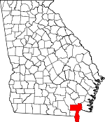
Charlton County, Georgia Basics:


Charlton County Georgia - Government Site

Population: 13,289
Area: 774 square miles
County seat: Folkston
Area code(s) in use: 912
Time zone: EST
High school graduate or higher: 67.9%
Bachelor's degree or higher: 9.9%
Median household income: $39,511
Persons in poverty: 15.2%
Home ownership rate: 78.0%
Mean travel time to work: 24.6 minutes


Adjacent counties:
Baker (FL)  Brantley  Camden  Clinch  Nassau (FL)  Ware  

Find in Georgia

Map of the Charlton County area


Our detail map of Charlton County shows the Charlton County, Georgia boundary lines and other interesting items.

Places in Charlton County, Georgia

  Airports     show all on map

Davis Field Airport

  Bays     show all on map

The Basin

  Bends     show all on map

The Big Bend of Saint Marys River

  Bridges     show all on map

Earnest A Bell Bridge, Hopkins Bridge, Smith Bridge, Stokes Bridge, Stokes Bridge (historical)

  Buildings     show all on map

Charlton County Courthouse, Charlton County Fire Department Station 1, Charlton County Fire Department Station 2, Charlton County Fire Department Station 3, Charlton County Fire Department Station 4, Charlton County Fire Department Station 5, Charlton County Jail, Charlton County Sheriff's Office, D Ray James Correctional Facility, Folkston City Hall, Folkston Police Department, Homeland Police Department

  Canals     show all on map

Saint Marys Cut

  Capes     show all on map

Crooked Sapling Point

  Cemeteries     show all on map

Antioch Cemetery, Bethel Cemetery, Boones Creek Cemetery, Corinth Cemetery, Cornhouse Creek Cemetery, Emmaus Cemetery, Homeland Cemetery, Johnson Cemetery, Lee Cemetery, Little Phoebe Cemetery, Lowther Cemetery, Moniac Cemetery, Mount Carmel Cemetery, Neeley Cemetery, O'Berry Cemetery, Pineview Cemetery, Prospect Cemetery, Saint George Cemetery, Sand Hill Cemetery, Sardis Cemetery, Traders Hill Cemetery, Traders Hill Cemetery

  Churches     show all on map

Antioch Church (historical), Bethel Church, Bethlehem Holiness Church, Boone Creek Church, Calvary Church, Camp Pinckney Church, Church of Christ, Church of God, Corinth Primitive Baptist Church, Emmaus Church, First Assembly of God Church, First Baptist Church, Folkston Methodist Church, Grace Chapel, Homeland Pentecostal Church, Jerusalem Holiness Church, Kingdom Hall Church, Little Phebe Church, Moniac Church, Mount Carmel Baptist Church, Mount New Home Church, New Life Church, Peoples Church, Philadelphia Church, Pinckney United Methodist Church, Pine Grove Church, Piney Grove Church, Prospect Church, Racepond Church, Saint Matthews Baptist Church, Sand Hill Church, Sardis Church, Traders Hill Church, Traders Hill Methodist Church (historical), Winokur Baptist Church

  Cliffs     show all on map

Gormans Bluff, Hich Bluff, Shirley Bluff

  Crossings     show all on map

Highway Park Ferry (historical), Rollinsons Ferry (historical)

  Dams     show all on map

Charlton County Lake Dam, Gowen Lake Dam, Lake Deborah Dam, Ray and Hannaford Lake Dam

  Flats     show all on map

Trouble Valley

  Hospitals     show all on map

Charlton County Health Center, Charlton Memorial Hospital, Charlton Memorial Hospital

  Islands     show all on map

Billys Island, Bush Island, Camp Island, Cedar Hammock, Cedar Hammocks, Chesser Island, Clay Island, Clewis Island, Cravens Island, Dog Island, Duck Island, Floyds Island, Fowl Roost Island, Gallberry Island, Grassy Island, Grassy Island, Greasy Branch Island, Green Hammock, Hickory Hammock, Hickory Island, Horse Island, Horseshoe Island, Indian Island, Jones Island, Little Island, Lloyd Island, Long Island, Macks Island, Macks Island, McDonald Island, Meat Island, Middle Island, Minnies Island, Mixons Hammock, Palmetto Island, Pine Hammock, Rabbit Island, Rabbit Island, Roasting Ear Island, Round Timber Island, Sandy Island, Sweet Gum Island, Turkey Island, Warren Island, Wilson Hammock

  Lakes     show all on map

Bear Lake, Bee Gum Lake, Big Lake, Big Water Lake, Billys Lake, Bluff Lake, Boggy Lake, Bush Lake, Camp Lake, Camphose Lake, Christie Lake, Coward Lake, Cypress Lake, Dinner Pond, Double Lakes, Double Lakes, Duck Lake, Durdin Lake, Eagle Nest Lake, Elder Lake, Fishingpole Lake, Flag Lake, Galepost Lake, Grassy Lake, Half Moon Lake, Hannom Lake, House Lake, Jack Lake, Lake Paxton, Little Double Lakes, Log Lake, Long Lake, Long Lake, Marys Lake, Minnies Lake, Mose Lake, Mud Lake, North Lake, Perch Lake, Picnic Lake, Pond Lake, Sand Lake, Shaw Lake, Sometime Hole, South Lake, Square Lake, Stump Lake, Trout Lake, Trout Lake, Widow Lake, Worley Lake

  Locales     show all on map

Box Landing, Burch Siding, Camp Cornelia, Cooneys Landing, Davis Boat Landing, Folkston Golf Club, Folkston Water Pollution Control Plant, Hawkins Shop Landing, Kingfisher Landing, Moody Landing, Stephen Foster State Park, Suggs Still (historical), White Sand Landing

  Parks     show all on map

Homeland Park, Okefenokee National Wildlife Refuge, Suwannee Canal Recreation Area

  Populated Places     show all on map

Boggy, Camp Pinkney (historical), Centerville (historical), Clarking, Cypress Siding, Ferry Landing, Folkston, Homeland, Layton, Mattox, McLeods Mill, Moniac, Newell, Oakdale, Paxton, Petersons (historical), Pinehurst, Prescott (historical), Racepond, Saint George, Silver Hill, Stanley Landing, Stokesville, Toledo, Traders Hill, Uptonville, Winokur, Woodstock (historical)

  Reserves     show all on map

Okefenokee Wilderness

  Reservoirs     show all on map

Charlton County Lake, Davis Pond, Gowen Lake, Lake Deborah, Ray and Hannaford Lake

  Ridges     show all on map

Trail Ridge

  Schools     show all on map

Bethone Middle School, Bethune Elementary School, Boones Creek School (historical), Canaday School (historical), Charlton County High School, Charlton County High School, Chesser School (historical), Chism School (historical), Davis School (historical), Folkston Elementary School, Folkston Middle School, Mount Zion Church (historical), Oquin School (historical), Petty School (historical), Prescott School (historical), Saint George Elementary School, Sandusky School (historical), Sardis School (historical), Stokes School (historical), Toledo School (historical), Traders Hill School (historical), Williams School (historical)

  Streams     show all on map

Baileys Branch, Baker Branch, Barber Branch, Ben Branch, Bird Wing Run, Boone Creek, Clay Branch, Cornhouse Creek, Cross Swamp, East Fork Suwannee River, Greasy Branch, Green Branch, Harris Creek, Hatchers Branch, Joaquin Creek, Little Spanish Creek, Long Branch, Melton Branch, Middle Fork Suwannee River, Mill Branch, Mims Creek, North Fork Suwannee River, River Styx, Saucer Branch, School Branch, Spanish Creek, Sparkman Creek, Spring Branch, Stanley Branch, Starland Branch, Thomas Branch, Tiger Branch, Tiger Branch, Turkey Branch

  Summits     show all on map

Ellicotts Mound

  Swamps     show all on map

Bee Gum Prairie, Big Bay, Big Water Prairie, Billys Lake, Brandy Bay, Caney Branch, Carters Prairie, Chase Prairie, Christie Prairie, Coward Lake Prairie, Dark Thick, Durdin Prairie, Floyds Island Prairie, Green Swamp, Jackson Bay, Long Lake, Mays Bluff Branch (historical), Outside Bay, Redbird Prairie, Roberts Bay, Sapling Prairie, Schoolhouse Bay, Territory Prairie, Trout Lake Prairie, Whites Flat Bay, Winding Branch

  Towers     show all on map

Toledo Lookout Tower, Winokur Lookout Tower, WOKF-FM (Folkston)

  Trails     show all on map

Okefenokee Wilderness Canoe Trail,

Charlton County, Georgia Population By Race (2012 estimate)

RacePopulation
WhiteCharlton County White population 8,6788,677  
BlackCharlton County Black population 4,2524,252
MixedCharlton County Mixed population 199199
AsianCharlton County Asian population 8079
American IndianCharlton County American Indian population 6666
Hawaiian & Pacific IslanderCharlton County Hawaiian & Pacific Islander population 00

Additional population tables :
State population table
Georgia population by county