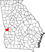
Chattahoochee County, Georgia Basics:
Chattahoochee County Georgia - Government Site
Population: 13,183
Area: 249 square miles
County seat: Cusseta
Area code(s) in use: 706
Time zone: EST
High school graduate or higher: 92.8%
Bachelor's degree or higher: 28.1%
Median household income: $48,684
Persons in poverty: 13.6%
Home ownership rate: 29.8%
Mean travel time to work: 14.5 minutes
Adjacent counties:
Marion Muscogee Russell (AL) Stewart Talbot Webster
Places in Chattahoochee County, Georgia
Lawson Army Airfield (Fort Benning) McBrides Bridge Chattahoochee County Courthouse,
Chattahoochee County Jail,
Chattahoochee County Sheriff's Office,
Chattahoochee County Volunteer Fire Department,
Cusseta - Chattahoochee Volunteer Fire Department,
Cusseta Police Department,
Fort Benning Military Police Department,
Victory Lodge Goodhope Cemetery,
Harmony Cemetery,
Wilkinson Cemetery Fort Benning South Census Designated Place (historical) Christopher Church,
County Line Church,
Fellowship Church (historical),
Friendship Church,
Good Hope Church,
Good Hope Church (historical),
Harmony Baptist Church,
Harmony Church (historical),
Liberty Hill Church,
Mission Church (historical),
Mount Olive Church,
Mount Pilgrim Church (historical),
Mount Zion Church (historical),
Prosperity Church (historical),
Saint Matthew Church (historical),
Saint Pauls Church,
Shelton Church (historical),
Sweet Home Church (historical),
Zion Hills Church McBride Ford,
Turkey Ford Anderson Lake Dam,
Armory Creek Dam,
Bagley Lake Dam,
Dykes Pond Dam,
Gordy Pond Dam,
Hards Pond Dam,
Kings Pond Dam,
Millers Lake Dam,
Saint Regis Pond Dam,
Twilight Pond Dam,
Victory Pond Dam,
Weems Pond Dam Martin Army Community Hospital Cooks Mill Pond,
Daniels Pond,
McMurrin Pond Bon Acre Landing,
Bradley Landing,
Carhart Store (historical),
Chambers Landing,
Cody Landing,
Cooks Mill (historical),
Culpepper Store (historical),
Fort Benning Mall Shopping Center,
Gallups Mill (historical),
Hollis Mill (historical),
Kings Mill (historical),
Thomas Mill (historical),
Underwood Mill (historical) Fort Benning River Bend Park Central Springs,
Christopher,
Cottage Mills (historical),
Cusseta,
Eelbeck,
Fort Benning,
Gobblers Hill,
Halloca (historical),
Heineburg Village (historical),
Ida Vesper,
Jamestown,
Kasihta (historical),
Manta,
McDaniel Manor,
Ochillee,
Renfroe,
Shack (historical),
Woolfolk (historical) Cottage Mills Post Office (historical),
Cusseta Post Office, Eelbeck Post Office (historical),
Fort Benning Post Office, Halloca Post Office (historical), Harp Post Office (historical), Hichitee Post Office (historical), Idavesper Post Office (historical), Idlehour Post Office (historical), Jamestown Post Office (historical), Millville Post Office (historical), Ochillee Post Office (historical), Oswitchee Post Office (historical), Parkman Post Office (historical), Pine Knot Post Office (historical), Renfroe Post Office (historical), Shack Post Office (historical), Thad Post Office (historical), Uno Post Office (historical)
Anderson Lake,
Armory Creek Reservoir,
Averetts Pond,
Bagley Lake,
Clear Creek Pond,
Dykes Pond,
Gordy Pond,
Hards Pond,
Harps Pond,
Kings Millpond,
Kings Pond,
Kisseck Pond (historical),
McMath Pond,
Millers Lake,
Mobleys Pond,
Pope Pond,
Russ Pond,
Saint Regis Paper Company Pond,
Schley Pond,
Schley Pond (historical),
Snelling Pond,
Stephens Pond,
Twilight Pond,
Upper Kings Pond,
Victoria Pond,
Victory Pond,
Weems Pond,
Woodruff Pond Barkeley Ridge,
Brown Ridge,
Comfort Ridge,
Langwell Ridge,
Riley Ridge,
Running Ridge,
Sexton Ridge,
Strickland Ridge Chattahoochee County Education Center,
Edward White School,
Faith School,
Favorsville School (historical),
Friendship School,
Herbert J Dexter School,
Kingsville School (historical),
Patch Kindergarten,
Pine Knot School (historical),
Providence School (historical),
Richard G Wilson School,
Saint Mathews School Sulphur Spring Bagley Creek,
Bonham Creek,
Cany Creek,
Clear Creek,
Cooks Branch,
Gilbert Creek,
Halloca Creek,
Harps Creek,
Hewell Creek,
Hichitee Creek,
Hollis Branch,
Hollis Creek,
Kings Mill Creek,
Lemert Creek,
Little Hichitee Creek,
Little Juniper Creek,
Little Pine Knot Creek,
McMurrin Branch,
Mill Creek,
Ochillee Creek,
Oswichee Creek,
Pine Knot Creek,
Randall Creek,
Red Mill Creek,
Sally Branch,
Sewelson Creek,
Shell Creek,
Smith Creek,
Spring Branch,
Spring Creek,
Stevens Branch,
Trestrail Creek,
Wolf Creek Acheson Hill,
Anderson Hill,
Bailey Hill,
Bardman Hill,
Bomford Hill,
Bouton Hill,
Breckenridge Hill,
Buma Hill,
Burks Hill,
Bush Hill,
Carson Hill,
Cleveland Hill,
Coacher Hill,
Colyer Hill,
Conrad Hill,
Cope Hill,
Craig Hill,
Craston Hill,
Cunningham Hill,
Davidson Hill,
Davis Hill,
Delario Hill,
Detrow Hill,
Ebbert Hill,
Elliott Hill,
Gow Hill,
Gray Hill,
Green Hill,
Griswold Hill,
Hamilton Hill,
Hawkinson Hill,
Herman Hill,
Hess Hill,
Higley Hill,
Holliday Hill,
Humphreys Hill,
Hutchcraft Hill,
Jobes Hill,
Jordan Hill,
Journey Hill,
Lambert Hill,
Lee Hill,
Long Hill,
Lyons Hill,
Mason Hill,
McClusky Hill,
McKenna Hill,
McLaughlin Hill,
Minter Hill,
Montgomery Hill,
Norwat Hill,
Oliver Hill,
Owens Hill,
Powell Hill,
Ray Hill,
Redwood Hill,
Reeve Hill,
Reynolds Hill,
Riche Hill,
Rivet Hill,
Rockwell Hill,
Rockwood Hill,
Ross Hill,
Rowan Hill,
Ryans Hill,
Selby Hill,
Singleton Hill,
Smith Hill,
Smyth Hill,
Stevenson Hill,
Tally Hill,
Thompson Hill,
Torrell Hill,
Toy Hill,
Tubbs Hill,
Turner Hill,
Vanvoris Hill,
Wadsworth Hill,
Walter Hill,
Wells Hill,
Winstead Hill,
Woodward Hill Gallups Millpond Chattahoochee Lookout Tower,
WRBL-TV (Columbus),
WTVM-TV (Columbus),
WVRK-FM (Columbus),

