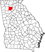
Cherokee County, Georgia Basics:


Cherokee County Georgia - Government Site

Population: 220,973
Area: 422 square miles
County seat: Canton
Area code(s) in use: 770
Time zone: EST
High school graduate or higher: 88.9%
Bachelor's degree or higher: 34.6%
Median household income: $67,928
Persons in poverty: 8.4%
Home ownership rate: 79.9%
Mean travel time to work: 32.0 minutes


Adjacent counties:
Bartow  Cobb  Dawson  Forsyth  Fulton  Gordon  Pickens  

Find in Georgia

Map of the Cherokee County area


Our detail map of Cherokee County shows the Cherokee County, Georgia boundary lines and other interesting items.

Places in Cherokee County, Georgia

  Airports     show all on map

Air Acres Airport, Cherokee County Airport, Georgia Lite Flite Airport, Moore Airstrip, Pegasus Run Airport, Stringer Airport

  Bridges     show all on map

Knox Bridge, Little River Bridge, Moores Mill Bridge

  Buildings     show all on map

Ball Ground Fire Department, Ball Ground Police Department, Canton City Hall, Canton Fire Department Station 11, Canton Fire Department Station 16, Canton Police Department, Cherokee County Administration Building, Cherokee County Board of Education, Cherokee County Courthouse, Cherokee County Emergency Management Service Station Number 6, Cherokee County EMS 2 Fire Station, Cherokee County EMS 4 Fire Station, Cherokee County Fire and Emergency Services Station 12, Cherokee County Fire and Rescue, Cherokee County Fire Department Little River Station, Cherokee County Fire Department Station 19, Cherokee County Fire Department Station 2, Cherokee County Fire Department Station 20, Cherokee County Fire Department Station 4 Free Home, Cherokee County Jail, Cherokee County Marshal's Office, Cherokee County Public Safety Building, Cherokee County Sheriff East Precinct, Cherokee County Sheriff's Office Bridgemill Precinct, Cherokee County Sheriff's Office Freehome Precinct, Cherokee County Sheriff's Office Headquarters, Cherokee County Sheriff's Office Hickory Flat Precinct, Cherokee County Sheriff's Office Oak Grove Precinct, Cherokee County Sheriff's Office Waleska Precinct, Cherokee County Station 1 Oak Grove Fire Station, Circle Five Volunteer Fire Department, Clayton Community Volunteer Fire Department Station 6, Georgia Station Patrol Post 28 Police Station, Gymnastics Recreation Center, Hickory Flat Fire Department Station 23, Hickory Flat Fire Department Station 3, Hickory Flat Fire Department Station 32, Holbrook Campground Volunteer Fire Department, Holly Springs Police Department, Holly Springs Volunteer Fire Department, Lake Arrowhead Volunteer Fire Department, Mica Fire Department, Nelson Volunteer Fire Department, North Canton Volunteer Fire Department, Salacoa Volunteer Fire Department, Sutallee Volunteer Fire Department, Woodstock Fire Department Station 10, Woodstock Fire Department Station 14, Woodstock Fire Department Station 24, Woodstock Police Department, Woodstock Public Library, Yellow Creek Volunteer Fire Department

  Cemeteries     show all on map

Alexander Cemetery, Ball Ground Baptist Cemetery, Ball Ground City Cemetery, Brooks Cemetery, Cane Creek Cemetery, Cherokee Memorial Park, Dowda Cemetery, Enon Cemetery, Fairview Cemetery, Georgia National Cemetery, Hickory Log Cemetery, Hutcherson Cemetery, Keith Cemetery, Knox Cemetery, Lovingood Cemetery, Mahan Cemetery, McFarland Cemetery, Pugh Cemetery, River View Cemetery, Rolling Hills Memory Gardens Cemetery, Smith Cemetery, Stevens Cemetery, Trippe Cemetery, Wheeler Cemetery

  Churches     show all on map

Allen Temple, Antioch Church, Arbor Hill Church, Ball Ground Baptist Church, Ball Ground Methodist Church, Bascomb Baptist Church, Bells Ferry Church, Bethel Church, Bethel Tabernacle Church, Bethesda Church, Big Springs Church, Brier Patch Church, Buffington Church, Calvary Community Church, Calvary Temple, Cane Creek Church (historical), Carmel Church, Chalcedonia Church, Cherokee Christian Fellowship Church, Cherokee Presbyterian Church, Cherry Grove Church, Christian Praise Center, Church of God, Church of God, Clayton Church, Conn's Creek Baptist Church, Cornerstone Community Church, Crossroad Church, Crystal Springs Church, Elbethel Church, Empowerment Tabernacle Christian Church, Etowah Church, Fairview Church, Fairview Methodist Church, Faith Church, Ficklen Church (historical), Fields Chapel, First Baptist Church, First Methodist Episcopal Church South, Goshen Church, Grace Church, Grace Church, Harvest Church, Hickory Flat Church of God, Hickory Log Church, Hightower Baptist Church, Hillcrest Baptist Church, Holly Springs Methodist Church, Hopewell Baptist Church, Hopewell Church, Indian Knoll Baptist Church, Land Mark Church, Lebanon United Methodist Church, Liberty Church, Liberty Grove Church, Lighthouse Church, Little River Church, Macedonia Baptist Church, Macedonia Church, Mica Church, Mill Creek Church, Mount Calvary Church, Mount Carmel Church, Mount Gilead Church, Mount Helen Church, Mount Olive Church, Mount Olivet Church, Mount Zion Baptist Church, Mount Zion Church, New Bethel Baptist Church, New Covenant Church, New Covenant Church, New Friendship Church, New Hightower Church (historical), New Home Church, New Hope Church, New Hope Church, New Liberty Church, New Light Church, New Light Church, New Victoria Church, Northpointe Church, Northside Church, Oak Grove Baptist Church, Oak Grove Church, Oak Grove United Methodist Church, Oakdale Church, Oasis of Love Church, Old Damascus Church, Olive Vine Church, Orange Methodist Church, Philadelphia Church, Pilgrim Church, Pleasant Arbor Church, Pleasant Union Church, Praise Cathedral, Promised Land Church, Refuge Church, Resurrection Anglican Church, Rock Springs Church, Saint Clements Church, Saint Paul Cemetery, Salacoa Church, Sardis Baptist Church, Sharp Mountain Baptist Church, Shiloh Church, Shiloh Methodist Church, Shoal Creek Baptist Church, Shoal Creek Church, Sixes Methodist Church, Souls Harbor Church, South Cherokee Church, Stonecrest Church, Sunlight Church, Sweetwater Church, The Cross Full Gospel Church, Timothy Lutheran Church, Toonigh Baptist Church, Toonigh Church of God, Trinity Church, Union Arbor Church, Union Hill Methodist Church, Victory Baptist Church, Victory Church, Waleska Church, Welcome All Baptist Church, Welcome Valley Church, Woodstock Baptist Church, Woodstock Church, Woodstock First Baptist Church, Woodstock Methodist Church, Woodstock Presbyterian Church, Woodstock Presbyterian Church, Word of Faith Church, Word of Life Church, Zion Baptist Church, Zion Temple

  Crossings     show all on map

Exit 4, Exit 5, Interchange 120

  Dams     show all on map

Atlanta Gas Light Lake Dam, Bartholomew Lake Dam, Beaver Lake Dam, Beck Lake Dam, Blalock Lake Dam, Bradshaw Lake Dam, Bryon Dam, Buice Lake Dam, Canton Creek Lake Dam, Canton Mills Lake Dam, Carmichael Lake Dam, Cherokee Estates Lake Dam, Chickasaw Lake Dam, Colony Land Development Lake Dam, Ellison Lake Dam, Ford Lake Dam, Freedrick Lake Dam, Georgia Marble Company Lake Dam, Lacy Lake Dam, Lake Arrowhead Dam, Lake Cherful Dam, Lake Forrest Subdivision Dam, Little River Structure Number 13 Dam, Little River-Coosa River Dam Number 22, Little River-Coosa River Watershed Dam Number 15, Little River-Coosa River Watershed Dam Number 17, Little River-Coosa River Watershed Dam Number 19, Little River-Coosa River Watershed Dam Number 21, McDaniel Lake Dam, Mill Canton Creek Structure Number 10 Dam, Mill Canton Creek Structure Number 12 Dam, Mill Canton Creek Structure Number Four Dam, Mill Canton Creek Structure Number Seven Dam, Mill Canton Creek Structure Number Six Dam, Mill Canton Structure Number Eight Dam, Mill Canton Structure Number Three Dam, Sallacoa Creek Watershed Dam Number 95, Sellers Lake Dam, Sharp Mountain Creek Structure Number Five Dam, Sharp Mountain Creek Structure Number Seven Dam, Sharp Mountain Creek Structure Number Six Dam, Stamp Shoal Creek Structure Number One Dam, Stamp Shoal Creek Structure Number Two Dam, Thurmond Lake Dam, Tustian Lake Dam, Waters Lake Dam

  Hospitals     show all on map

Northside Hospital Cherokee Campus, R T Jones Memorial Hospital, Woodstock Hospital

  Locales     show all on map

Atlantic Yacht Club, Bascomb Commercial Park, Bell Industrial Park, Bells Ferry Landing Shopping Center, Camp Kiwanis, Canton Corners Shopping Center, Canton Country Club, Canton Mill Commons Shopping Center, Canton Village Shopping Center, Centre at Woodstock Shopping Center, Cherokee Commons Shopping Center, Cherokee Mill, Crossroads Village Shopping Center, Dixie Industrial Park, Dixie Speedway, Dunwoody Methodist Youth Camp, Etowah Yacht Club, Galts Ferry Landing, Hickory Flat Village Shopping Center, Hickory Grove Shopping Center, Iron Horse Farms, Kellogg Creek Day Use Area, Noonday Baptist Association Camp, Parkway Business Center, Payne Campground, Riverplace Shopping Center, Riverstone Mill Shopping Center, Rose Creek Shopping Center, Shady Hook Shopping Center, South Cherokee Industrial Park, Sweetwater Creek Campground, Towne Lake Square Shopping Center, Towne Lake Village Shopping Center, Westside Office Center, Whispering Pines Camp, Woodstock Commons Shopping Center, Woodstock Crossing Shopping Center, Woodstock Place Shopping Center, Woodstock Village Shopping Center

  Military     show all on map

Fort Buffington (historical), Fort Sixes (historical)

  Mines     show all on map

Bell-Star Mine, Cherokee Mine, Cherokee Quarry, Clarkston Mine, Downing Creek Placer Mine, Franklin Gold Mine, Macou Prospect, Putnam Mine, Sixes Mine, Standard and Swift Mines, Three Hundred and One Mine

  Parks     show all on map

Boling Park, Brown Park, Canton Commerical Historic District, Canton Historic District, Cherokee County Park, Cushing Memorial Park (historical), Dupree Park, Harmon Field, Hobgood Park, Kenney Askew County Park, Lake Allatoona Managed Hunting Area, Payne Public Use Area

  Populated Places     show all on map

Allatoona Pass, Andersonville, Ansley Forest, Applewood, Arnold Mill, Ashley Forest, Audubon Forest, Avery, Ball Ground, Bascombs Springs, Batesville, Beasley Gap, Bells Ferry Place, Bluff Creek, Bramble Oak, Breeze Hill Estates, Brookwood Estates, Buffington, Burris Crossroads, Canton, Cardinal Woods, Carmichael Crossroads, Cedar Mill Crossing, Centerville (historical), Cherecobb Estates, Cherokee, Cherokee Estates, Cherokee Forest, Cherokee Mobile Home Park, Cherokee South, Colemans Bluff, Colemans Landing, Colony Center, Colony Springs, Colony Woods, Creek Hollow South, Creek View, Creighton (historical), Cross Creek, Deerchase, Dobbs Estates, Driftwood Forest, Driftwood Station, Eastgate Mobile Home Park, Emerald Forest, Etowah Mills, Farmington, Fields Landing, Fountain Lake Mobile Home Park, Free Home, Gibson Acres, Glenell, Gober, Greely, Hardman Place, Harmony, Heritage Place, Hickory Flat, Hickory Log (historical), Hills-A-Rolling, Holbrook, Holly Springs, Hunters Mill, Independence Walk, Indian Valley Estates, Joshua Landing, Keithsburg, Kellogg Creek, Kellogg Creek North, Kingridge Estates, Kingridge North, Kingridge West, Knotts Landing, Knotts Pointe, Laffingal, Lake Forest, Lake Pointe, Land of Lakes, Lathemtown, Lebanon, Little River Crossing, Little River Landing, Little River North, Little River South, Macedonia, McCollum Acres, Mica, Mill Creek Crossing, Misty Mountain, Motes Hill, Mountain Ridge, North Canton, Northridge Estates, Nowlin Estates, Nowlin Hall, Nowlin Station, Oak Grove, Oak Grove Estates, Old Cedar Creek, Ophir, Orange, Pages Mobile Home Park, Park Place Estates, Payne, Payne Mobile Home Park, Pine Hill, Pioneer Crossing, Plantation Walk, Red Bank (historical), Ridgewood Estates, River Oaks, Riverchase, Rocky Creek, Rocky Springs, Salacoa, Salem Woods, Savanna Place, Selikway (historical), Shadowbrook, Shadowood Mobile Home Park, Sharp Top, Sherwood Forest, Skyridge, South Canton, Southern Oaks, Southfork, Spring Valley Mobile Home Park, Springfield, Stir Up Manor, Stockwood Estates, Sturbridge, Sumpter Ridge, Sunny Brook, Sutali (historical), Sutallee, Tagwahi (historical), The Arbors, The Crossroads, The Woodlands, The Woods at Colony Crossing, Timberlake North, Tomahawk, Trickum Hills, Twin Pines, Tyson Estates, Union Hill, Univeter, Upland Estates, Vestavia Estates, Victoria, Victoria Landing, Village Green, Waleska, Westwood Station, White City, Wiley Bridge Junction, Willow Tree, Wood Glen, Woodstock, Woodstock Station, Woodwind Station, Worley Crossroads, Yacht Club Estates

  Post Offices     show all on map

Ball Ground Post Office, Canton Post Office, Woodstock Post Office

  Reservoirs     show all on map

Allatoona Lake, Almond Lake, Atlanta Gas Light Lake, Ball Lake, Bartholomew Lake, Beaver Lake, Beck Lake, Blalock Lake, Bradshaw Lake, Bryon Lake, Buice Lake, Cagle Lake, Canton Creek Lake, Canton Mills Lake, Carmichael Lake, Chickasaw Lake, Cline Lake, Colony Land Development Lake, Dean Lake, Ellison Lake, Ford Lake, Fredrick Lake, Garrison Lake, Georgia Marble Company Lake, Gordy Lake, Great Southeastern Land Fund Lake, Hurte Lake, Kraft Lake, Lacy Lake, Lake Arrowhead, Lake Cherful, Lake Cherful Dam, Lusk Lake, McDaniel Lake, Michael Lake, Moore Lake, Payne-Smith Lake, Pittman Lake, Reece Lake, Roberts Lake (historical), Sellers Lake, Shell Lake, Statham Lake, Stephens Lake, Thurmond Lake, Turner Lake, Tustian Lake, Waters Lake

  Schools     show all on map

American Heritage Academy, Arnold Mill Elementary School, Avery Elementary School, Ball Ground Elementary School, Bascomb Elementary School, Boston Elementary School, Buffington Elementary School (historical), Bunche School, Canton Elementary School, Canton Grammar School (historical), Canton High School (historical), Canton Public School (historical), Carmel Elementary School, Chapman Intermediate School, Chattahoochee Technical College Woodstock Campus, Cherokee Christian School, Cherokee High School, Cherry Grove School (historical), Clayton Elementary School, Community Christian School, Conn Creek School (historical), Creekland Middle School, Creekview High School, Crossroads High and Middle School, Dean Rusk Middle School, E T Booth Middle School, Etowah High School, Flatbottom School (historical), Free Home Elementary School, Freedom Middle School, Furtah Preparatory School, Garland Mountain School (historical), Harvest Baptist School, Hasty Elementary School, Hickory Flat Elementary School, Holly Springs Elementary School, Johnston Elementary School, Joseph Knox Elementary School, Lays School, Liberty Elementary School, Liberty School (historical), Little River Elementary School, Macedonia Elementary School, Macedonia Elementary School, Mackey School (historical), Mill Creek Middle School, Moore School, Mountain Road Elementary School, Northstar at L R Tippens Education Center, Oak Grove Elementary School, Oakland School (historical), Polaris Evening School, R M Moore Elementary School, Ralph Bunche Center, Rehobeth Christian Academy, Reinhardt College, River Ridge High School, Riverdale School (historical), Riverdale School (historical), Sequoyah High School, Sixes Elementary School, Teasley Middle School, Tippens School, Union Hill School, Woodstock Elementary School, Woodstock High School, Woodstock Middle School

  Springs     show all on map

Mineral Spring, Turkeytoter Spring

  Streams     show all on map

Avery Creek, Badger Creek, Blankets Creek, Bluff Creek, Board Tree Creek, Bryant Creek, Buzzard Flapper Creek, Byrd Creek, Cagle Creek, Cane Creek, Canton Creek, Conn Creek, Downing Creek, Dry Branch, Edward Creek, Gorman Branch, Hickory Log Creek, Hurricane Creek, Jug Creek, Kellogg Creek, Knox Creek, Laurel Branch, Little Creek, Little Creek, Little River, Little Shoal Creek, Long Swamp Creek, Lost Town Creek, McCanless Creek, McCory Creek, Mill Creek, Moore Creek, Murphy Creek, Nally Branch, Noonday Creek, Owl Creek, Posey Branch, Puckett Creek, Riggin Creek, Rock House Creek, Rocky Bottom Branch, Rocky Creek, Rose Creek, Rubes Creek, Sardis Creek, Schoolhouse Creek, Scott Mill Creek, Settingdown Creek, Sharp Mountain Creek, Shoal Creek, Shut-in Creek, Smithwick Creek, Soap Creek, Sweetwater Creek, Toonigh Creek, Wiley Creek

  Summits     show all on map

Bear Mountain, Byrd Mountain, Dry Pond Mountain, Garland Mountain, Hickory Log Mountain, Oakey Mountain, Pine Log Mountain, Polecat Mountain, Posey Mountain

  Towers     show all on map

Pine Log Lookout Tower, WCHK-AM (Canton), WCHK-FM (Canton), WTLK-TV (Rome)

  Valleys     show all on map

Grassy Hollow, Salacoa Valley,

Cherokee County, Georgia Population By Race (2012 estimate)

RacePopulation
WhiteCherokee County White population 197,992197,991  
BlackCherokee County Black population 13,70013,700
MixedCherokee County Mixed population 3,9783,977
American IndianCherokee County American Indian population 1,1051,104
Hawaiian & Pacific IslanderCherokee County Hawaiian & Pacific Islander population 221220

Additional population tables :
State population table
Georgia population by county