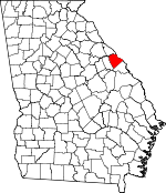
Columbia County, Georgia Basics:


Columbia County Georgia - Government Site

Population: 131,563
Area: 290 square miles
County seat: Appling
Area code(s) in use: 706
Time zone: EST
High school graduate or higher: 91.0%
Bachelor's degree or higher: 34.7%
Median household income: $67,295
Persons in poverty: 8.0%
Home ownership rate: 78.9%
Mean travel time to work: 24.4 minutes


Adjacent counties:
Aiken (SC)  Augusta - Richmond  Edgefield (SC)  Lincoln  McCormick (SC)  McDuffie  

Find in Georgia

Map of the Columbia County area


Our detail map of Columbia County shows the Columbia County, Georgia boundary lines and other interesting items.

Places in Columbia County, Georgia

  Airports     show all on map

Carpenter Airport, Flying J Airstrip

  Bridges     show all on map

Furys Ferry Bridge, Legg Bridge

  Buildings     show all on map

Columbia County Courthouse, Columbia County Jail, Columbia County Marshal's Department, Columbia County Sheriff's Department, Columbia County Sheriff's Office Substation, Georgia State Patrol Troop E Post 25 Thomson, Grovetown City Hall, Grovetown City Jail, Grovetown Department of Public Safety, Grovetown Department of Public Safety Station 1, Grovetown Public Safety Fire Station 2, Harlem Department of Public Safety Station 1, Harlem Department of Public Safety Station 2, Harlem Jail, Harlem Police Department, Martinez - Columbia Fire Rescue Station 1 Headquarters, Martinez - Columbia Fire Rescue Station 10, Martinez - Columbia Fire Rescue Station 11, Martinez - Columbia Fire Rescue Station 12, Martinez - Columbia Fire Rescue Station 13, Martinez - Columbia Fire Rescue Station 14, Martinez - Columbia Fire Rescue Station 15, Martinez - Columbia Fire Rescue Station 16, Martinez - Columbia Fire Rescue Station 2, Martinez - Columbia Fire Rescue Station 3, Martinez - Columbia Fire Rescue Station 4, Martinez - Columbia Fire Rescue Station 5, Martinez - Columbia Fire Rescue Station 6, Martinez - Columbia Fire Rescue Station 7, Martinez - Columbia Fire Rescue Station 8, Martinez - Columbia Fire Rescue Station 9

  Capes     show all on map

The Point

  Cemeteries     show all on map

Abilene Cemetery, Beale Cemetery, Beard-Young Cemetery, Bellevue Memorial Gardens, Bethel Cemetery, Blanchard Cemetery, Bugg Cemetery, Bynum Cemetery, Doyle Cemetery, Evans Cemetery, Hardin Cemetery, King Cemetery, Knox Cemetery, Knox Cemetery, Lamkin Cemetery, Newman Cemetery, Old Avery Cemetery, Old Union Baptist Church Cemetery, Snellings Memorial Acre, Spring Grove Cemetery, Steiner Cemetery, Sturgis Cemetery, Susie Bostic Cemetery

  Census     show all on map

Appling Census Designated Place, Evans Census Designated Place, Martinez Census Designated Place

  Channels     show all on map

Four Mile Reach

  Churches     show all on map

Abelene Church (historical), Abilene Church, Appling Church, Appling Grove Church, Bethel Church (historical), Bethesda Church, Cedar Grove Church, Church of the Lord Jesus Christ, Clarks Grove Church, Cobb Grove Church, Crawford Grove Church, Damascus Church, Dunn Chapel, Emanuel Church, Fountain Grove Church (historical), Friendship Church, Galilee Church, Gospel Watery Branch Church, Holiness Church, Hosea Chapel (historical), Jerusalem Church, Jones Chapel, Kiokee Church, Lamkin Grove Church, Lewis Memorial Church, Macedonia Church, Macedonia Church, Martinez Church, Marvin Church, Mount Carmel Church, Mount Enna Church, Mount Moriah Church, Mount Olive Church, Mount Pleasant Church, Mount Tabor Church, Mount Zion Church, New Hope Church, Oak Grove Church, Old Kiokee Church, Old Union Baptist Church, Olive Grove Church, Philadelphia Church, Piney Grove Church, Poplar Springs Church, Powells Church, Prince of Peace Church, Rehoboth Church, Reids Chapel, Riverview Church, Second Mount Carmel Church, Sharon Church, Shiloh Church, Simonia Church, Smith Church (historical), Smith Grove Church, Solid Rock Church, Steiner Grove Church, Trinity Church, Trinity Church (historical), Water Branch Church, White Oak Church, Woodlawn Church

  Crossings     show all on map

Dents Ferry (historical), Exit 61, Exit 62, Exit 63, Furys Ferry (historical), Lockhart Ferry (historical), McCord Ferry (historical), Middletons Ferry (historical), Price Ferry (historical)

  Dams     show all on map

Augusta City Lock and Dam, Baldwins Lake Dam, Bennett Dam, Bolgla Lake Dam, Bowen Pond Dam, Camelot Lake Dam, Casaga Lake Dam, Cawley Lake Dam, Columbia Land Corporation Lake Dam, Crawford Lake Dam, Eubank Lake Dam, Helen Huffman Lake Dam, Hickory Lake Dam, Hill Lake Dam, Idlewylde Lake Dam, J. Strom Thurmond Dam, Lower Hitts Lake Dam, Lower Pollards Lake Dam, Mobile Home Park Lake Dam A, Mobile Home Park Lake Dam B, Morris Lake Dam, Mount Olive Lake Dam, Mullens Lake Dam, Oak Lake Dam, Pollards Corner Lake Dam, Pollards Lake Dam, Silver Lake Dam, Smith Lake Dam, Spring Lake Dam, Stevens Creek Dam, Upper Hitt Lake Dam, Verderys Pond Dam, Wells Lake Dam, Woodbridge Lake Dam

  Islands     show all on map

German Island, Griffin Island (historical), Ninety Nine Islands

  Lakes     show all on map

Johns Pond

  Locales     show all on map

Central School, Columbia County Industrial Park, Columbia Square Shopping Center, Evans Village Shopping Center, Fanglewood Camp, Griffith Siding, Hamilton Branch Campground, Jones Creek Golf Course, Merchants Village Shopping Center, Mistletoe Corners, Old Petersburg Road Camping Area, Park Place Shopping Center, Prices Mill (historical), Pumpkin Center, Ridge Road Camping Area, Tanglewood Camp, West Town Shopping Center, White Oak Campground, Winfield Campsites

  Parks     show all on map

Fort Gordon Recreation Area, Keg Creek State Park, Marshall Monument, Mistletoe State Park

  Populated Places     show all on map

Appling, Arrow Head, Avery Landing, Belglade, Berzelia, Blanchard Park, Bonaire Heights, Briarwood, Buffalo Ranch, Calloway Woods, Cambridge, Camelot, Campania, Candlewood Crossing, Casa Bella, Casa Linda, Chimney Hill, Cluese (historical), Columbia Heights, Country Place, Creek View, Deerwood Acres, Deerwood Estates, Delph (historical), Dunn Chapel, Edgewood, Eubank (historical), Evans, Evans Mill, Evanston, Fairington Estates, Farmington, Fernbrook, Forest Creek, Forrest (historical), Glennwood, Grovetown, Harlem, Highview Acres, Hill and Dale Trailer Park, Hillbrook, Holiday Park, Howell, Idylwilde, Jamaica Estates, Jushua Tree Villas, Kensington, Kettle Creek, Kiokee, Lake Cumberland West, Lake Royal, Lamkin, Leah, Lewiston, Lewiston Downs, Lulaville, Maddox, Maple Creek, Martinez, Maysville (historical), Meadowview, Memory Park, Oak Lake, Petersburg Station, Phillips Estates, Phinizy, Pinewood, Pollards Corner, Quail Creek, Ridge Crossing, Ridge Point, Ropers Crossroads, Rosemont, Sawdust, Sedgefield, Shadowmoor, Shady Grove Estates, Shenandoah, Shenandoah Woods, Silver Maple Ridge, Smithwick, Smithwyck, Snead, Spring Lakes, Stallings Place, Stevens Creek, Stevens Creek West, Stevens Pointe, Sugarcreek, Sweetbriar, Village at Watervale, Watervale, West Hampton, West Lynne, Westlake, Westmont, Westport, Westwood, Whispering Pine Mobile Home Park, Windmill Plantation, Windy Acres Trailer Park, Windy Ridge Estates, Winfield, Winfield Hill, Woodbridge, Woodland, Wymberly, Wynngate

  Post Offices     show all on map

Appling Post Office, Martinez Post Office

  Reservoirs     show all on map

Baldwins Lake, Bennett Lake, Berzelia Pond, Big Smoak Lake, Bolgla Lake, Bowen Pond, Camelot Lake, Casaga Lake, Cawley Lake, Columbia Land Corporation Lake, Crawford Lake, Eubank Lake, Hardys Lake, Helen Huffman Lake, Hickory Lake, Hill Lake, Idlewylde Lake, J. Strom Thurmond Reservoir, Lower Hitts Lake, Lower Pollards Lake, Marshal and Magruder Pond, Marshall Pond, McManus Ponds, Mobile Home Park Lake A, Mobile Home Park Lake B, Morris Lake, Mount Olive Lake, Mullens Lake, Oak Lake, Pollards Corner Lake, Pollards Lake, Reynolds Pond, Scruggs Pond, Silver Lake, Smith Lake, Spring Lake, Stewarts Ponds, Sunrise Lake, Upper Hitt Lake, Verderys Pond, Wells Lake, Woodbridge Lake

  Schools     show all on map

Academics Plus School, Augusta Christian Day School, Augusta Christian School, Augusta Country Day School, Augusta Preparatory Day School, Augusta Seventh Day Adventist School, Bel Air Elementary School, Blue Ridge Elementary School, Brookwood Elementary School, Calloway School (historical), Cedar Ridge Elementary School, Central High School (historical), Central School, China Hill School (historical), Clanttian Grove School (historical), Columbia County Crossroads Academy, Columbia Middle School, Ellis School, Enoch School (historical), Euchee Creek Elementary School, Evans Elementary School, Evans High School, Evans Middle School, Fairmont School (historical), Greater Augusta Christian Academy, Greenbrier Elementary School, Greenbrier High School, Greenbrier Middle School, Grovetown Elementary School, Grovetown High School, Grovetown Middle School, Harlem High School, Harlem Middle School, Kiokee School, Lakeside High School, Lakeside Middle School, Lamkin Grove School (historical), Lewiston Elementary School, Martinez Elementary School, Martinez Montessori School, Morris School (historical), North Columbia Elementary School, North Harlem Elementary School, River Ridge Elementary School, Riverside Elementary School, Riverside Middle School, Smith School (historical), South Columbia Elementary School, South Harlem School, Stallings Island Middle School, Steiner School (historical), Stevens Creek Elementary School, Walnut Grove School (historical), Water Branch School (historical), Westmont Elementary School, Westview School (historical)

  Streams     show all on map

Allen Branch, Bailey Branch, Benton Branch, Bettys Branch, Big Branch, Broad Branch, Burns Branch, Canidy Branch, Cat Branch, Chigoe Creek, Cliatt Creek, Crawford Creek, Delph Branch, Dickey Branch, Greenbrier Creek, Harris Branch, Hawes Branch, Hickory Branch, Horn Creek, Jones Creek, Keg Creek, Kelly Branch, Kiokee Creek, Lake Spring Creek, Little Kiokee Creek, Little River, Little River, Lloyd Creek, Long Branch, Mill Branch, Mims Branch, Mount Enna Branch, Muddy Branch, Polar Bridge Creek, Reed Creek, Sadie Morris Creek, Satterwhite Branch, Shiloh Fork, Spring Creek, Tudor Branch, Uchee Creek, Walton Branch, White Oak Branch

  Summits     show all on map

Burks Mountain, Mount Carmel

  Towers     show all on map

WMTZ-FM (Martinez),

Columbia County, Georgia Population By Race (2012 estimate)

RacePopulation
WhiteColumbia County White population 100,909100,908  
BlackColumbia County Black population 21,05021,050
AsianColumbia County Asian population 5,3945,394
MixedColumbia County Mixed population 3,5523,552
American IndianColumbia County American Indian population 526526
Hawaiian & Pacific IslanderColumbia County Hawaiian & Pacific Islander population 263263

Additional population tables :
State population table
Georgia population by county