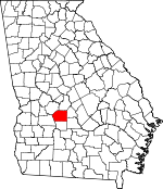
Dooly County, Georgia Basics:


Dooly County Georgia - Government Site

Population: 14,316
Area: 392 square miles
County seat: Vienna
Area code(s) in use: 478
Time zone: EST
High school graduate or higher: 72.5%
Bachelor's degree or higher: 9.7%
Median household income: $30,789
Persons in poverty: 28.6%
Home ownership rate: 68.7%
Mean travel time to work: 18.4 minutes


Adjacent counties:
Crisp  Houston  Macon  Pulaski  Sumter  Wilcox  

Find in Georgia

Map of the Dooly County area


Our detail map of Dooly County shows the Dooly County, Georgia boundary lines and other interesting items.

Places in Dooly County, Georgia

  Airports     show all on map

Byromville Aerodrome, Everidge Airport, Flint River Nursery Airport, Macks Field, Pennington Field, Posey Airport, Roney Farms Airport, Snow Hill Airstrip, Wrights Field Airport

  Bays     show all on map

Glory Hole

  Bridges     show all on map

Luther Storey Bridge, Quinn Bridge

  Buildings     show all on map

Byromville City Hall, Byromville Police Department, Dooly County Courthouse, Dooly County Fire Department, Dooly County Fire Department Byromville Station, Dooly County Fire Department Dooly High Station, Dooly County Fire Department Drayton Station, Dooly County Fire Department Pinehurst Station, Dooly County Fire Department Third District Station, Dooly County Jail, Dooly County Sheriff's Office, Dooly State Prison, J Lane Greenhouses and Nursery, Lilly City Hall, Pinehurst Police Department, Unadilla Fire and Rescue Station 1, Unadilla Fire and Rescue Station 2, Unadilla Fire and Rescue Station 3, Unadilla Police Department, Vienna City Hall, Vienna Police Department, Vienna Volunteer Fire Department

  Capes     show all on map

Smokehouse Point

  Cemeteries     show all on map

Bay Point Cemetery, Collier Cemetery, Evergreen Cemetery, Forehand Cemetery, Forehand Cemetery, Forest Chapel Cemetery, Hepzibah Cemetery, Joiner Cemetery, Liberty Cemetery, Macedonia Cemetery, Mars Hill Cemetery, Middlebrooks Cemetery, Midway Cemetery, Mount Bezor Cemetery, Mount Moriah Cemetery, Mount Olive Cemetery, Mount Olive Cemetery, Mount Pleasant Cemetery, Mount Vernon Cemetery, New Bethel Cemetery, Oakland Cemetery, Owen Cemetery, Pine Ridge Cemetery, Pinehurst City Cemetery, Pleasant Hill Cemetery, Poplar Spring Cemetery, Rock Hill Cemetery, Rock Spring Cemetery, Saint Johns Cemetery, Shiloh Cemetery, Smyrna Cemetery, Snow Springs Cemetery, Swearinger Cemetery, Vienna City Cemetery, Walnut Cemetery

  Churches     show all on map

Baker Field Church, Bay Point Church, Bethel Baptist Church, Bethel Church (historical), Bethlehem Church, Big Poplar Church, Browns Chapel, Cedar Valley Church, County Line Church, County Line Church (historical), Double Branch Church, Double Churches (historical), Drayton Baptist Church, Drayton Methodist Church, Ebenezer Baptist Church, Faith Baptist Church, First Baptist Church, First Missionary Church, Forest Chapel, Friendship Methodist Church, Harmony Baptist Church, Holiness Church, Holly Grove Church, Lebanon Primitive Baptist Church, Liberty Church, Little Creek Church, Love Chapel (historical), Macedonia Methodist Church, Mars Hill Church, Marvin Church (historical), McCallay, Midway Church, Mount Moriah Church, Mount Olive Church, Mount Pleasant Baptist Church, Mount Vernon Baptist Church, Mount Zion Methodist Church, Nelson Grove Church (historical), New Bethel Church, New Mount Zion Church, New Poplar Spring Church, Oakland Church (historical), Old Mount Zion Church, Pine Level Church, Pine Ridge Primitive Baptist Church, Pinehurst Baptist Church, Pleasant Hill Church, Pleasant Hill Free Will Baptist Church, Pleasant Valley Church, Poplar Springs Church, Red Hill Church, Richwood Church, Rock Dam Church (historical), Rock Hill Primitive Baptist Church, Rock Spring Church (historical), Saint Johns Church, Saint Marks Baptist Church, Saint Pauls Chapel, Saint Pauls Church (historical), Sanctified Holiness Church, Sandy Mount Church (historical), Shady Grove Church, Shiloh Church, Smyrna Church, Smyrna Church, Snow Methodist Church, Spring Hill Baptist Church, Unadilla Baptist Church, Vienna Methodist Church

  Crossings     show all on map

Exit 36, Exit 37, Exit 38, Exit 39, Exit 40

  Dams     show all on map

Bartenfield Dam, Brown Pond Dam, C E Thompson Dam Two, Daniels Pond Dam, Ford Dam, Griggs North Dam, Griggs South Dam, J B Riner Dam, Jones Dam, Peavy Dam, Ryner Pond Dam, Sanders Pond Dam, Sangster Dam, Thompson Dam

  Hospitals     show all on map

Dooly Medical Center

  Islands     show all on map

Whisky Island

  Lakes     show all on map

Alligator Pond, Gum Pond, Holland Park, Layfield Pond, Oakbin Pond, Pocosin Pond, Wolf Pond (historical)

  Locales     show all on map

Dooly Campground, Dooly County Farm (historical), George Walton Experimental Station, Lester Brothers Store (historical), Smiths Store (historical)

  Parks     show all on map

Anthony Bowens Park, George Busbee Park, Harmon Park, Walter F George Park

  Populated Places     show all on map

Bakerfield (historical), Byromville, Dooling, Drayton, Emerich, Findlay, Intatchkalgi (historical), Lilly, Mars Hill Crossroads, Pinehurst, Richwood, Snow Spring, Sugar Hill, Tippettville, Unadilla, Vienna

  Post Offices     show all on map

Lilly Post Office, Unadilla Post Office, Vienna Post Office

  Reservoirs     show all on map

Bartenfield Lake, Brown Pond, Daniels Pond, Ford Lake, Griggs North Lake, Griggs South Lake, Jones Lake, Peavy Lake, Ryner Pond, Sanders Pond, Sangster Lake, Thompson Lake

  Schools     show all on map

Atkins School (historical), Butler Hill School (historical), Dooly COunty High School, Double Branch School (historical), Dunaway School (historical), Faith Christian School, Forest Chapel School (historical), Franklin School (historical), King School (historical), Mars Hill School (historical), Morgan Grove School (historical), Rock Hill School (historical), Sandy Mount School (historical), Unadilla Elementary School, Unadilla High School, Union High School (historical), Vance School, Vienna Elementary School, William Chapel School (historical), Williams School (historical)

  Springs     show all on map

Collier Spring, Davis Spring, Dpuble Lime Sinks, New Leonard Spring

  Streams     show all on map

Bratcher Creek, Camp Creek, Jalappa Branch, Lilly Branch, Limestone Creek, Little Creek, Little Creek, Little Creek, Little Pennahatchee Creek, Pennahatchee Creek, Reedy Branch, Rock Hill Creek, Rogers Branch, Sandy Mount Creek, Shiver Branch, Turkey Creek, Wallace Branch, Wildcat Creek

  Summits     show all on map

Sugar Hill

  Swamps     show all on map

Bass Pond, Cypress Pond, Lester Pond

  Towers     show all on map

Walton Lookout Tower, WWWN-AM (Vienna),

Dooly County, Georgia Population By Race (2012 estimate)

RacePopulation
WhiteDooly County White population 7,0437,043  
BlackDooly County Black population 7,0157,014
MixedDooly County Mixed population 115114
AsianDooly County Asian population 100100
American IndianDooly County American Indian population 2928
Hawaiian & Pacific IslanderDooly County Hawaiian & Pacific Islander population 1414

Additional population tables :
State population table
Georgia population by county