Gilmer County, Georgia Basics:


Gilmer County Georgia - Government Site

Population: 28,212
Area: 427 square miles
County seat: Ellijay
Area code(s) in use: 706
Time zone: EST
High school graduate or higher: 75.9%
Bachelor's degree or higher: 14.5%
Median household income: $37,257
Persons in poverty: 20.4%
Home ownership rate: 72.6%
Mean travel time to work: 28.0 minutes

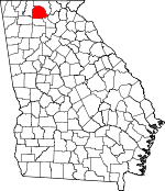
Adjacent counties:
Dawson  Fannin  Gordon  Murray  Pickens  

Find in Georgia

Map of the Gilmer County area


Our detail map of Gilmer County shows the Gilmer County, Georgia boundary lines and other interesting items.

Places in Gilmer County, Georgia

  Airports     show all on map

Gilmer County Airport

  Basins     show all on map

Double Hogpen

  Bridges     show all on map

Charles Soule Bridge, Cobb Bridge

  Buildings     show all on map

East Ellijay Police Department, Ellijay Fire Department, Ellijay Police Department, Gilmer County Courthouse, Gilmer County Detention Center, Gilmer County Fire Department Station 1, Gilmer County Fire Department Station 2, Gilmer County Fire Department Station 3, Gilmer County Fire Department Station 4, Gilmer County Fire Department Station 5, Gilmer County Fire Department Station 6, Gilmer County Fire Department Station 7, Gilmer County Fire Department Station 8, Gilmer County Sheriff, Gilmer County Sheriff's Department

  Cemeteries     show all on map

Berean Baptist Church Cemetery, Boardtown Church of Christ Cemetery, Calvary Way Baptist Church Cemetery, Cartecay United Methodist Church Cemetery, Cartecay United Methodist Church Cemetery, Cashes Valley Cemetery, Chapman Cemetery, Cherry Log Baptist Church Cemetery, Cherry Log Baptist Church Old Cemetery, Clear Creek Baptist Church Cemetery, Crossroads Baptist Church Cemetery, Dover Chapel Cemetery, East Ellijay City Cemetery, East New Hope Baptist Church Cemetery, Ebenezer Baptist Church Cemetery, Ellijay Cemetery, Flat Branch Baptist Church Cemetery, Flat Creek Baptist Church Cemetery, Flint Hill Cemetery, Gates Chapel United Methodist Church Cemetery, Goble Family Cemetery, Jarrett Cemetery, Johnson Cemetery, Jones Cemetery, Liberty Baptist Church Cemetery, Macedonia Baptist Church Cemetery, Mount Nebo Cemetery, Mount Pisgah Baptist Church Cemetery, Mount Pleasant Baptist Church Cemetery Number 1, Mount Pleasant Baptist Church Cemetery Number 2, Mount Zion Baptist Church Cemetery, Mountaintown Baptist Church Cemetery, New Hope Baptist Church Cemetery, New Liberty Baptist Church Cemetery, Nine Mile United Methodist Church Cemetery, Northcutt Cemetery, Oak Hill United Methodist Church Cemetery, Pisgah Church of Christ Cemetery, Pleasant Gap Baptist Church Cemetery, Pleasant Grove Baptist Church Cemetery, Pleasant Hill Baptist Church Cemetery, Pleasant Valley Baptist Church Cemetery, Ridgeway Baptist Church Cemetery, River Hill Baptist Church Cemetery, Rock Creek Baptist Church Cemetery, Salem Baptist Church Cemetery, Scrougetown Baptist Church Cemetery, Seventh-day Adventist Church Cemetery, Shady Grove Baptist Church Cemetery, Sharp Cemetery, Sunlight Baptist Church Cemetery, Tails Creek Baptist Church Cemetery, Talona Baptist Church Cemetery, Tickanetley Primitive Baptist Church, Turniptown Baptist Church Cemetery, Underwood Cemetery, Upper Cherry Log Cemetery, Whitestone Baptist Church Cemetery, Yukon Cemetery, Zion Hill Baptist Church Cemetery

  Census     show all on map

Cherry Log Census Designated Place, Cherry Log Division (historical)

  Churches     show all on map

Berean Church, Bible Church, Blue Ridge Church (historical), Boardtown Church, Cartecay Church, Cashes Valley Church of Christ, Cherry Log Church, Christian Church, Church of Christ, Clear Creek Church, Cross Roads Church, Doll Mountain Church, East Liberty Church, Ebenezer Church, Ellijay Church of Christ, First Baptist Church of Ellijay, Flat Branch Church, Flat Creek Baptist Church, Flint Hill Church, Gates Chapel, Gospel Temple, Happy Valley Church, Liberty Church, Little Ebenezer Church, Macedonia Church, Mount Pisgah Church, Mount Pleasant Church, Mount Pleasant Church, Mount Vernon Church, Mount Zion Church, Mountaintown Church, New Hope Baptist Church, New Liberty Church, New Pleasant Grove Church, Ninemile Church, Northcutt Church, Oak Hill Church, Pisgah Church, Pisgah Church, Pleasant Gap Church, Pleasant Grove Church, Pleasant Hill Baptist Church, Pleasant Valley Baptist Church, Ridgeway Church, River Hill Church, Rock Creek Church, Salem Baptist Church, Scrougetown Church, Seventh Day Adventist Church, Sunlight Church, Tails Creek Church, Talona Church, Tickanetley Primitive Baptist Church, Turniptown Church, Zion Hill Church

  Cliffs     show all on map

White Cliffs

  Dams     show all on map

Cartecay River Watershed Dam Number Seven, Cartecay River Watershed Structure Number Five Dam, Cartecay River Watershed Structure Number Six Dam, Cartecay Watershed Dam Number 10, Cartecay Watershed Dam Number Eight, Cartecay Watershed Dam Number One, Cartecay Watershed Dam Number Three, Childers Lake Dam, Chitwood Lake Dam, Clotfelter Lake Dam, Diamond Lure Lake Dam, Ellijay River Watershed Dam Number 11, Ellijay River Watershed Dam Number 12, Ellijay Watershed Dam Number 10, Ellijay Watershed Dam Number Four, Ellijay Watershed Dam Number Nine, Ellijay Watershed Dam Number One, Ellijay Watershed Dam Number Two, Ellijay Watershed Number Three Dam, Fowler Lake Dam, Gibson Lake Dam, Hensley Lake Dam, Johnson Lake Dam, Lake Atagahi Dam, Lake Dakwa Dam, Lake Yanu Dam, Little Turniptown Creek Lake Dam, Logan Lake Dam, Lovejoy Lake Dam, McCuller Lake Dam, Miller-Grindley Pond Dam, Montag Lake Dam, Mountaintown Creek Watershed Dam Number Four, Mountaintown Creek Watershed Dam Number One, Mountaintown Creek Watershed Dam Number Three, Mountaintown Creek Watershed Dam Number Two, Powell Lake Dam, Rainbow Lake Dam, Sailors Lake Dam, Shaw Lake Dam, Talking Rock Watershed Dam Number 10

  Flats     show all on map

Loggy Flats

  Gaps     show all on map

Alaculsy Gap, Augerhole Gap, Bear Pen Gap, Betty Gap, Big Creek Gap, Brushy Gap, Bushy Head Gap, Doublehead Gap, Frozen Gap, Halloway Gap, Hardslate Gap, Hatley Gap, Hickorynut Gap, Horsepen Gap, Hudson Gap, Indian Grave Gap, Low Gap, McKenny Gap, Painter Gap, Persimmon Gap, Ramp Gap, Rolston Gap, Sassafras Gap, Stanley Gap, Steamy Gap, Stone Pile Gap, Stover Gap, Tipton Gap, Wolfpen Gap

  Hospitals     show all on map

North Georgia Medical Center

  Lakes     show all on map

Hills Lake, Hughes Lake

  Locales     show all on map

Barnes Creek Camping Area, Camp Patoka, Cartecay Camp Ground (historical), Gilmer County Country Club, Gilmer County Prison Camp, Law Grounds, Protection, Riverside Plaza Shopping Center, South Main Plaza Shopping Center

  Military     show all on map

Fort Hetzel (historical)

  Mines     show all on map

Ellijay Quarry

  Parks     show all on map

Doll Mountain Recreation Area, Gilmer Fairground, Harris Branch Recreation Area, Rich Mountain Wildlife Management Area, Ridgeway Recreation Area, Woodridge Branch Recreation Area

  Populated Places     show all on map

Ai, Big Creek, Burnett, Carlisle (historical), Cartecay, Cherry Log, Chopped Oak, Conasauga (historical), Diamond, Dyke, East Ellijay, Elders, Ella Gap, Ellijay, Flat Branch, Gartrell (historical), Goose Island, Higdon Mill (historical), Jones Mill (historical), Kiker, Licklog (historical), Lucius, Marion, Mountaintown, New Hope, Northcutt, Oak Hill, Oakland, Ollie, Pike (historical), Pisgah, Pleasant Hill, Pleasant Valley, Quill, Ratcliff (historical), Rolston, Roosevelt, Roundtop, Roy, Santaluca, Snider (historical), Stanley Mill (historical), Tails Creek, Talona, Tickanetley, Tioga, Town Creek, Turniptown (historical), Webb, White Path, Whitestone, Yukon

  Post Offices     show all on map

Cherrylog Post Office, East Ellijay Post Office, Ella Gap Post Office (historical), Ellijay Post Office, Yukon Post Office (historical)

  Ranges     show all on map

Rich Mountain

  Reserves     show all on map

Rich Mountain Wilderness

  Reservoirs     show all on map

Allen Lake, Bearden Lake, Carters Lake, Childers Lake, Chitwood Lake, Clotfelter Lake, Corbin Lake, Dakwa Lake, Davenport Lake, Diamond Lake, Diamond Lure Lake, Fowler Lake, Garland Lake, Gibson Lake, Gibson Lake, Goose Island Lake, Hensley Lake, Hill Lake, Johnson Lake, Jones Lake, Laurel Creek Lake, Little Lake, Little Turniptown Creek Lake, Logan Lake, Lovejoy Lake, Lowman Lake, Lowman Lake, McCuller Lake, Miller-Grindley Pond, Montag Lake, Mountaintown Watershed Lake Number Three, Noblin Lake, Parks Lake, Postell Lake, Powell Lake, Rainbow Lake, Sailors Lake, Shaw Lake, Sisson Lake, Teague Lake, Turniptown Lake, Walnut Mountain Lake A

  Ridges     show all on map

Deadline Ridge, Fox Mountain, Horse Ridge, Leading Ridge, Long Ridge, Parks Ridge, Pine Ridge, Rattlesnake Lead, Redrock Ridge, Saddle Ridge, Snaggy Lead, Wildcat Lead

  Schools     show all on map

Big Creek School (historical), Blue Ridge School (historical), Boardtown School (historical), Bucktown School (historical), Cashes Valley School (historical), Cherrying School, Clear Creek Middle School, Clear Creek School (historical), East Ellijay Elementary School, Ellijay Elementary School, Ellijay Institute (historical), Ellijay Middle School, Ellijay Primary School, Ellijay Seminary (historical), Ellijay Seventh Day Adventist School, Flat Branch School (historical), Gilmer Academy (historical), Gilmer County Crossroads Alternative School, Gilmer High School, Gilmer Middle School, Grace Christian School, Harper School (historical), Henry Grady School, Mount Pisgah School (historical), Mountain View Elementary School, Mountaintown School (historical), Nine Mile School (historical), North Georgia Christian Academy, Oak Hill School (historical), Oakland Elementary School, Owltown School (historical), Pleasant Gap School (historical), Pleasant Grove School (historical), Ridgeway School (historical), Rocky Creek School, Rolston School (historical), Salem School (historical), Seventh Day Adventist School, Southwestern School, Twiggs School (historical)

  Springs     show all on map

Cold Spring

  Streams     show all on map

Allen Branch, Amy Creek, Anderson Creek, Anderson Creek, Banks Branch, Bear Creek, Bear Paw Branch, Bearden Creek, Boardtown Creek, Bream Branch, Briar Creek, Bryant Creek, Bucktown Creek, Burnett Branch, Butler Creek, Buzzard Roost Creek, Camp Branch, Carroll Creek, Cartecay River, Cherry Log Creek, Clear Creek, Coley Creek, Conasauga Creek, Crooked Branch, Crump Creek, Davis Creek, Demps Creek, Dillard Branch, Dugger Branch, Dyer Creek, East Mountaintown Creek, Ellijay River, Fall Branch, Fausett Creek, Fir Creek, Fisher Creek, Flat Branch, Flat Branch, Flat Branch, Flat Creek, Frady Creek, Garrett Branch, Gibson Creek, Goble Branch, Godfrey Branch, Gunstock Branch, Harkins Creek, Harper Creek, Harper Creek, Harris Creek, Hatley Branch, Heddy Creek, Hice Branch, Holden Creek, John Rogers Creek, Johnson Creek, Jones Creek, Kells Creek, Key Creek, Laurel Creek, Lewis Branch, Licklog Creek, Little Bear Creek, Little Rock Creek, Little Turniptown Creek, Long Branch, Long Branch, Mountaintown Creek, Oliver Creek, Owltown Creek, Pickett Branch, Pickett Creek, Pink Branch, Rock Creek, Rodgers Creek, Roger Laurel Branch, Rolston Creek, Ross Creek, Saltpeter Creek, Sevenmile Creek, Simons Branch, Sisson Creek, Stillhouse Branch, Stover Creek, Tails Creek, Talona Creek, Tickanetley Creek, Town Creek, Turkey Creek, Turniptown Creek, Turnpike Branch, Vandegriff Creek, Weaver Creek, Whitepath Creek, Wildcat Creek, Willys Creek, Wolf Creek, Woodring Branch, Wurley Creek, Youther Creek

  Summits     show all on map

Aaron Mountain, Bart Top, Bear Den Mountain, Big Bald Mountain, Big Hill, Bird Mountain, Blalock Mountain, Brushy Top, Bushy Head Mountain, Cartecay Mountain, Chestnut Mountain, Colbert Mountain, Cold Mountain, Collins Mountain, Columbia Top, Demps Mountain, Dogwood Knob, Doll Mountain, Double Knob, Double Top, Douglas Mountain, Flat Top Mountain, Fowler Mountain, Frozen Knob, George Mountain, George Mountain, Gould Mountain, Granny Mountain, Hickorynut Mountain, High Top, Hightop, Horsepen Mountain, Howell Mountain, Indian Grave Knob, Jeff Mountain, Joel Mountain, Kimmons Mountain, Leatherwood Mountain, Little Bald Mountain, Little Bee Mountain, Locust Mountain, Marion Clayton Mountain, Owltown Mountain, Patterson Mountain, Pine Mountain, Pine Mountain, Pink Knob, Reese Mountain, Rich Mountain, Riley Mountain, Rocky Mountain, Round Mountain, Round Mountain, Saltpeter Mountain, Scroggin Knob, Sheep Knob, Stover Mountain, Talona Mountain, Tatum Mountain, Tickanetley Bald, Turkey Knob, Turkeypen Top, Turniptown Mountain, Wallace Mountain, Walnut Mountain, Wisnaint Mountain, Wolfpen Mountain

  Towers     show all on map

WLJA-AM (Ellijay), WLJA-FM (Ellijay)

  Trails     show all on map

Bear Creek Trail, Emery Creek Trail, Mountaintown Creek Trail

  Valleys     show all on map

Blackwell Cove, Cashes Valley, Horse Cove, Jackson Hollow,

Gilmer County, Georgia Population By Race (2012 estimate)

RacePopulation
WhiteGilmer County White population 27,28127,281  
MixedGilmer County Mixed population 310310
BlackGilmer County Black population 197197
American IndianGilmer County American Indian population 169169
Hawaiian & Pacific IslanderGilmer County Hawaiian & Pacific Islander population 141141
AsianGilmer County Asian population 113112

Additional population tables :
State population table
Georgia population by county