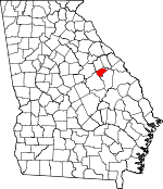
Glascock County, Georgia Basics:


Glascock County Georgia - Government Site

Population: 3,130
Area: 144 square miles
County seat: Gibson
Area code(s) in use: 706
Time zone: EST
High school graduate or higher: 78.0%
Bachelor's degree or higher: 9.3%
Median household income: $32,346
Persons in poverty: 23.7%
Home ownership rate: 69.5%
Mean travel time to work: 28.3 minutes


Adjacent counties:
Hancock  Jefferson  Warren  Washington  

Find in Georgia

Map of the Glascock County area


Our detail map of Glascock County shows the Glascock County, Georgia boundary lines and other interesting items.

Places in Glascock County, Georgia

  Buildings     show all on map

Edge Hill Volunteer Fire Department, Gibson - Glascock County Fire Department, Gibson Police Department, Glascock County Courthouse, Glascock County Sheriff's Office, Glascock Fire Department Station 2, Mitchell Volunteer Fire Department

  Cemeteries     show all on map

Allen Cemetery, Allen-Snider Cemetery, Bethel Cemetery, Braddy - Hilson Cemetery, Chalker Cemetery, Cooper Cemetery, Daniel Usry Cemetery, Edgehill Cemetery, Euphrates Cemetery, Fellowship Cemetery, Friendship Cemetery, George W Usry Cemetery, Gibson Branch Cemetery, Gibson City Cemetery, Glover Cemetery, Gracy Hobbs Cemetery, Griffen Cemetery, Griffin Chapel Cemetery, Hobbs Cemetery, Howard Cemetery, James Kelly Cemetery, Jordans Chapel Cemetery, Kitchens - Wilcher Cemetery, Land Cemetery, Llewellyn - Kitchens Cemetery, Magnolia Cemetery, McCoy Cemetery, McNair Cemetery, Mill Creek Cemetery, Mitchell Cemetery, Mitchell Cemetery, Mount Nebo Cemetery, Mount Zion Cemetery, Newsome Cemetery, Piney Grove Cemetery, Pool - Usry Cemetery, Rabun Cemetery, Rosa Bell Cemetery, Saint Paul Cemetery, Sandy Grove Cemetery, Seals - Kitchens Cemetery, Thankful Cemetery, Thomas Hadden Cemetery, Tompkins Cemetery, Towner Cemetery, Union Cemetery

  Churches     show all on map

Bethel Church, Edgehill First Church of God, Emanuel Church, Euphrates Church, Fellowship Church, Friendship Church, Full Gospel Holiness Church, Gibson Branch Church, Griffin Chapel, Jordan Chapel, Magnolia Church, Mill Creek Church, Mitchell Baptist Church, Mitchell Methodist Church, Mount Nebo Church, Mount Zion Church, Piney Grove Church, Saint Paul African Methodist Episcopal Church, Sandy Grove Baptist Church, Thankful Church, Zoar United Methodist Church

  Dams     show all on map

Blankenship Pond Dam, Kents Millpond Dam, Roberts Dam, Walden Lake Dam

  Locales     show all on map

Blakenship Mill

  Populated Places     show all on map

Agricola, Bastonville, Blume, David (historical), Edgehill, Five Points, Gibson, Glovers Millpond, Hadden, Harts, Mitchell

  Reservoirs     show all on map

Blankenship Pond, Caroline Lake, Kents Millpond, Roberts Lake, Walden Lake

  Schools     show all on map

Davis School, Glascock County Consolidated School, Steep Hollow School (historical)

  Streams     show all on map

Beechtree Creek, Big Branch, Big Creek, Bird Branch, Blue Spring Branch, Buzzard Branch, Chalk Hill Branch, Deep Creek, Fords Creek, Gin Branch, Gin Branch, Guy Branch, Harris Branch, Joes Creek, Jumping Gully Creek, Little Brier Creek, Magtail Branch, Mill Branch, Mill Creek, Philcher Creek, Thomson Ford Branch,

Glascock County, Georgia Population By Race (2012 estimate)

RacePopulation
WhiteGlascock County White population 2,8012,801  
BlackGlascock County Black population 279278
MixedGlascock County Mixed population 3434
American IndianGlascock County American Indian population 66
Hawaiian & Pacific IslanderGlascock County Hawaiian & Pacific Islander population 00

Additional population tables :
State population table
Georgia population by county