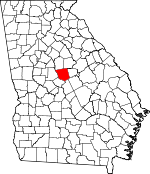
Jones County, Georgia Basics:


Jones County Georgia - Government Site

Population: 28,615
Area: 394 square miles
County seat: Gray
Area code(s) in use: 478
Time zone: EST
High school graduate or higher: 89.0%
Bachelor's degree or higher: 19.4%
Median household income: $53,085
Persons in poverty: 14.2%
Home ownership rate: 79.7%
Mean travel time to work: 25.9 minutes


Adjacent counties:
Baldwin  Bibb  Jasper  Monroe  Putnam  Twiggs  Wilkinson  

Find in Georgia

Map of the Jones County area


Our detail map of Jones County shows the Jones County, Georgia boundary lines and other interesting items.

Places in Jones County, Georgia

  Buildings     show all on map

Gray Fire Department, Gray Police Department, Hilchiti Experimental Forest Station, Jones County Fire Department Station 1, Jones County Fire Department Station 2, Jones County Fire Department Station 4, Jones County Fire Department Station 5A, Jones County Fire Department Station 5B, Jones County Fire Department Station 6, Jones County Fire Department Station 7, Jones County Fire Department Station 8, Jones County Jail, Jones County Sheriff's Department, Jones County Station 5A, Jones County Station 6, Jones County Station 7B, National Wildlife Refuge Headquarters, State Forestry Unit Headquarters

  Cemeteries     show all on map

Bradley Cemetery, Camp Hope Cemetery, Chapman Cemetery, Clawson Cemetery, Crutchfield Cemetery, Edwards Cemetery, Ethridge - Minter Cemetery, Fortville Cemetery, Gorden Cemetery, Gordon Cemetery, Happoldt - Stevens Cemetery, Harris Cemetery, Henderson Stripling Cemetery, Holland B Speller Cemetery, Humphries Cemetery, Hunt Cemetery, James Cemetery, John Gordon Cemetery, Jones Cemetery, Lewis Loyd Cemetery, Marys Chapel Cemetery, McKay Cemetery, Middle Georgia Memorial Gardens, Moore Cemetery, Mountain Springs Cemetery, New Hope Cemetery, New Salem Cemetery, Newby-Mitchell Cemetery, Pickart Cemetery, Round Oak Cemetery, Salem Cemetery, Sardis Cemetery, Stiles Cemetery, Walker - Pitts Cemetery, Watson and Couch Cemetery, William Woods Cemetery, Wincey Cemetery

  Churches     show all on map

Bethesda Church, Bethlehem Church, Blounts Chapel, Bradley Baptist Church, Calvery Church, Corinth Church (historical), East Juliette Church, Elam Church, Ellis Chapel, Frendship Church, Friendship Church, Hardys Chapel, Kings Chapel, Little Rock Church, Macedonia Church (historical), Marys Chapel (historical), Mount Pleasant Church, Mount Zion Church, Mount Zion Church (historical), Mountain Springs Church, New Hope Church, New Hope Church, New Salem Church, Piney Grove Church (historical), Pitts Chapel, Plentitude Church, Round Tree Methodist Church, Saint James Church, Saint James Church, Saint Luke Church (historical), Saint Marks Church, Saint Pauls Church, Saint Pauls Church, Sand Creek Church (historical), Sardis Church, Stewart Chapel, Union Hill Church, Wayside Presbyterian Church, Wiles Chapel (historical), Zion Hill Church

  Crossings     show all on map

Glover Ferry (historical), Holton Ferry (historical), Popes Ferry (historical)

  Dams     show all on map

Anderson Lake Dam, Baker Lake Dam, Bateman Lake Dam, Brasswells Lake Dam, Briscoe Dam, Cauley Lake Dam, Cheatham Dam, Cherokee Products Dam, Club Lake Dam, Coulters Lake Dam, Douglas Lake Dam, Ethridge Dam, Hodges Lake Dam, Howell Lake Dam, Hulett Dam, Hungerford Lake Dam, Jones Lake Dam, Lake Deer Run Dam, Lake Tonowanda Dam, Lowe Lake Dam, Lower Hawkins Lake Dam, Martin-Marietta Dam, Miller Creek Lake Dam, Mitchell Lake Dam, Moore Lake Dam, Nelsons Lake Dam, Newberry Dam, Polands Lake Dam, Ray Lake Dam, Rowland Dam, Slocumbs Lake Dam, Smith Dam, Steed Lake Dam, Upper Hawkins Lake Dam, Ussery Lake Dam, Walker Dam, Walker-Laney Dam, Washburn Dam, Williams Lake Number One Dam, Williams Lake Number Two Dam

  Forests     show all on map

Hitchiti Experimental Forest

  Islands     show all on map

Bridges Island

  Locales     show all on map

Blountsville Hunt Camp, Bonner Store (historical), Camp Joycliff, Camp Willis, Grady Creek Hunt Camp, Hillsboro Lake Picnic Area, Jarell Historical Plantation, Jarrell Plantation, Jones County Shopping Center, River North Country Club, Round Oak Lookout, Tribble Fields, Uncle Remus District Headquarters

  Parks     show all on map

Hilchiti Experimental Forest, Jarrell Plantation State Historic Site, Old Clinton Historic District, Piedmont National Wildlife Refuge

  Populated Places     show all on map

Belvedere Manor, Blountsville, Bowden Hills, Bradley, Bragg, Campbell (historical), Clinton, Crutchfield (historical), Cumslo, East Juliette, Ethridge, Fippin (historical), Five Points, Fortville, Gray, Greenberry Crossroads, Griswoldville, Haddock, James, Jones Acres, Joycliff Estates, Kings View, Morton, Mountain Springs, Pine Ridge, Pitts, Plentitude (historical), Postell, Round Oak, Smalls Crossing (historical), Stallings (historical), Three Points, Van Buren (historical), Wayside

  Post Offices     show all on map

Haddock Post Office

  Reservoirs     show all on map

Allisons Lake, Anderson Lake, Baker Lake, Bateman Lake, Brasswells Lake, Briscoe Lake, Cauley Lake, Cheatham Lake, Cherokee Products Lake, Club Lake, Coulters Lake, Douglas Lake, Eagle Lake, Ethridge Lake, Five Points Lake, Hillsboro Lake, Hodges Lake, Howell Lake, Hulett Lake, Hungerford Lake, Jones Lake, Lake Deer Run, Lake Jonesco, Lake Tonawanda, Lake Tonowanda, Lowe Lake, Lower Hawkins Lake, Martin-Marietta Lake, Miller Creek Lake, Mitchell Lake, Moore Lake, Nelsons Lake, Newberry Lake, Pippins Lake, Polands Lake, Ray Lake, Rowland Lake, Slocumbs Lake, Smith Lake, Steed Lake, Upper Hawkins Lake, Ussery Lake, Walker Lake, Walker-Laney Lake, Washburn Lake, Williams Lake Number One, Williams Lake Number Two

  Schools     show all on map

Blountsville Academy (historical), Bradley-Wayside School, Burden School (historical), Central Georgia Technical College - Jones County Center, Clifton Ridge Middle School, Clinton Academy (historical), Clinton Female Seminary (historical), Dames Ferry Elementary School, Fortville Academy (historical), Gray Elementary School, Gray Station Middle School, Green School (historical), Griswoldville Junior High School (historical), Haddock Junior High School (historical), James School (historical), Jones County High School, Juliette Junior High School (historical), Liberty School (historical), Litentie School (historical), Maggie Califf Learning Complex, Mattie Wells Elementary School, Planters Academy (historical), Round Oak Junior High School (historical), Three Points School (historical), Wells Primary School

  Streams     show all on map

Allisons Creek, Barn Branch, Bartlett Branch, Big Cedar Creek, Big Creek, Bonner Creek, Bray Branch, Buttlers Creek, Caney Creek, Cedar Creek, Crooked Creek, Falling Creek, Feagin Hill Creek, Glady Creek, Glawson Creek, Hog Creek, Hurricane Creek, Little Cedar Creek, Little Chehaw Creek, Little Creek, Little Falling Creek, Little Hog Creek, Marshal Creek, Mason Branch, McKay Branch, Miller Creek, Pratts Creek, Pumphouse Branch, Rock Creek, Sand Creek, Scoggins Creek, Shoal Creek, Third Branch, Town Creek, Tyson Branch, Wolf Creek

  Towers     show all on map

Five Points Lookout Tower, Round Oak Lookout Tower, WDEN-FM (Macon)

  Trails     show all on map

Allison Lake Wildlife Trail,

Jones County, Georgia Population By Race (2012 estimate)

RacePopulation
WhiteJones County White population 21,03221,032  
BlackJones County Black population 7,0117,010
MixedJones County Mixed population 286286
AsianJones County Asian population 229228
American IndianJones County American Indian population 8685
Hawaiian & Pacific IslanderJones County Hawaiian & Pacific Islander population 00

Additional population tables :
State population table
Georgia population by county