Lanier County, Georgia Basics:


Lanier County Georgia - Government Site

Population: 10,458
Area: 185 square miles
County seat: Lakeland
Area code(s) in use: 229
Time zone: EST
High school graduate or higher: 74.9%
Bachelor's degree or higher: 12.8%
Median household income: $41,867
Persons in poverty: 21.9%
Home ownership rate: 64.2%
Mean travel time to work: 22.9 minutes

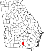
Adjacent counties:
Atkinson  Berrien  Clinch  Echols  Lowndes  

Find in Georgia

Map of the Lanier County area


Our detail map of Lanier County shows the Lanier County, Georgia boundary lines and other interesting items.

Places in Lanier County, Georgia

  Bays     show all on map

Clothespole Bay, Mullis Bay

  Bridges     show all on map

Dixon Mill Bridge

  Buildings     show all on map

James E Branch Fire Station, Lakeland - Lanier Fire and Rescue, Lakeland Police Department, Lanier County Fire Department Station 2 Stockton, Lanier County Fire Department Station 3, Lanier County Fire Department Station 4 Mud Creek, Lanier County Sheriff's Department, Robert L Patten Probation Detention Center, Westside Fire Station

  Cemeteries     show all on map

Foreman Cemetery, Lovejoy Cemetery

  Churches     show all on map

Browning Chapel, Carter Chapel, Empire Church, Fender Church, First Born Church, Irene Church, Knight Memorial Church, Mud Creek Church, New Hopewell Church, New Prospect Church, Oak Grove Church, Saint Louis Church, Silver Hill Church, Stockton Baptist Church, Union Church

  Dams     show all on map

Banks Lake Dam, Carter Lake Dam, Howell Lake Dam, Lake Irma Dam

  Flats     show all on map

Bennett Bay, Friars Bay

  Hospitals     show all on map

Louis Smith Memorial Hospital

  Islands     show all on map

Lightsey Hammock, Pine Islands, The Rocks

  Lakes     show all on map

Banks Lake, Fish Pond

  Locales     show all on map

Courthouse

  Military     show all on map

Moody Air Force Base

  Populated Places     show all on map

Greenwood, Lakeland, Stockton, Teeterville

  Reservoirs     show all on map

Banks Lake, Carter Lake, Darsey Pond, Howell Lake, Lake Irma, Pattens Pond, Rays Millpond

  Schools     show all on map

Carter School (historical), Good Hope School (historical), Hopewell School (historical), Lanier County High School, Lanier County Middle School, Lanier County Primary School

  Streams     show all on map

Alligator Run, Ben Creek, Big Creek, Copeland Branch, Cow Creek, Cross Creek, Dampier Branch, Darsey Mill Branch, Dixon Mill Creek, Fivemile Creek, Knight Creek, Mill Creek, Moore Branch, Mud Creek, Reedy Creek, Tenmile Creek

  Swamps     show all on map

Berryhill Pond, Fish Pond Bay, George Carter Island Bay, Lee Pond, Milltown Bay, Monk Pond, Owl Bay, Peters Bay, Steve Bay, Trail Pond,

Lanier County, Georgia Population By Race (2012 estimate)

RacePopulation
WhiteLanier County White population 7,4577,456  
BlackLanier County Black population 2,5312,530
MixedLanier County Mixed population 251250
AsianLanier County Asian population 125125
American IndianLanier County American Indian population 9494
Hawaiian & Pacific IslanderLanier County Hawaiian & Pacific Islander population 00

Additional population tables :
State population table
Georgia population by county