Lee County, Georgia Basics:


Lee County Georgia - Government Site

Population: 28,720
Area: 356 square miles
County seat: Leesburg
Area code(s) in use: 229
Time zone: EST
High school graduate or higher: 83.8%
Bachelor's degree or higher: 19.1%
Median household income: $58,400
Persons in poverty: 11.3%
Home ownership rate: 75.2%
Mean travel time to work: 21.6 minutes

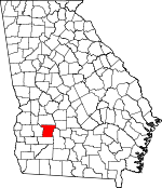
Adjacent counties:
Crisp  Dougherty  Sumter  Terrell  Worth  

Find in Georgia

Map of the Lee County area


Our detail map of Lee County shows the Lee County, Georgia boundary lines and other interesting items.

Places in Lee County, Georgia

  Airports     show all on map

Leesburg Spraying Airport, Smithville Airport

  Bridges     show all on map

Forrester Bridge, Hollis Bridge, Jackson Bridge, Nine Bridges, Starksville Bridge (historical)

  Buildings     show all on map

Lee County Courthouse, Lee County Emergency Medical Services Century Station, Lee County Emergency Medical Services Redbone Station, Lee County Fire Department Station 1 Leesburg, Lee County Fire Department Station 2 Century, Lee County Fire Department Station 3 Palmyra, Lee County Fire Department Station 4 Smithville, Lee County Fire Department Station 5 Redbone, Lee County Fire Department Station 6 Chokee 1, Lee County Fire Department Station 7 Chokee 2, Lee County Jail, Lee County Sheriff's Office, Lee State Prison, Lee State Prison Fire Station, Leesburg Police Department, Smithville Police Department

  Cemeteries     show all on map

Cowart Cemetery, Deidrich Cemetery, Henderson Cemetery, Larramore Cemetery, Leesburg Cemetery, Lowe Cemetery, Palmyra Cemetery, Thundering Springs Cemetery

  Churches     show all on map

Alpha Church, Antioch Church, Antioch Church (historical), Bethlehem-Lee Church, Green Grove Church, Jerusalem Grove Church, Jordan Grove Church, Kinchafoonee Church, Maedonia Church, Marthanna Grove Church, McAfee Church, Midway Church (historical), Mount Calvary Church, Mount Hope Church, Mount Middleton Church (historical), Mount Pleasant Church, Mount Pleasant Church, New Beulah Church, New Hope Church, New Hope Church (historical), New Pine Grove Church, Old Piney Grove Church, Phillips Grove Church, Piney Grove Church, Piney Grove Church (historical), Pleasant Green Church, Saint Johns Church, Saint Mathews Church, Saint Stephens Church, Shady Grove Church, Spring Hill Church, Thundering Springs Church, Wooten Church

  Crossings     show all on map

Coxs Ferry (historical)

  Dams     show all on map

Ballinger Lake Dam, Bodrey Lake Dam, Kaylor Lake Dam, King Lake Dam, Lower Wheatley Lake Dam, McCree Lake North Dam, McCree Lake South Dam, Mossy Dell Dam, Phillips Pond Dam, Sadlers Millpond Dam, Usry Lake Dam, Wheatley Lake North Dam

  Hospitals     show all on map

Anchorage Alcoholic Medical Center

  Lakes     show all on map

Coney Lake, Cypress Pond, Duck Roost Pond, Fish Pond, Fox Pond, James Pond, Middle Cypress Pond, Pye Pond, Stocks Pond, Sun Pond, White Pond

  Locales     show all on map

Colonial Plantation, Griffith Farm, Haley Plantation, Hartley Farm, Jones Store (historical), Liramores Store (historical), Oak Springs Ranch, Pentahope Farms, Pineland Plantation, Starr Farm, United States Pecan Field Station

  Military     show all on map

Nike Site TU-79C (historical), Nike Site TU-79L (historical)

  Parks     show all on map

Chehaw Indian Monument, Chehaw Park

  Populated Places     show all on map

Armena, Beloit, Byne Crossroads, Century, Chehaw, Chokee, Eagle Pond, Edwards (historical), Forrester, Jordan Place, Leesburg, Mossy Dell, New York (historical), Neyami, Nutview (historical), Oakland, Palmyra, Philema, Scrutchins, Smithville, Starksville, Stocks, Stocks (historical), Tutalosi (historical)

  Reservoirs     show all on map

Ballinger Lake, Bodrey Lake, Kaylor Lake, King Lake, Lower Wheatley Lake, McCree Lake North, McCree Lake South, Mossy Dell Lake, Phillips Pond, Sadlers Millpond, Usry Lake, Wheatley Lake North

  Schools     show all on map

Chokee School (historical), Heath School (historical), Hutchinson School (historical), Lee County Elementary School, Lee County High School, Redbone School (historical), Smithville Academy, Upper School

  Springs     show all on map

Graves Spring, Palmyra Springs

  Streams     show all on map

Boggy Branch, Chokee Creek, Fowltown Creek, Fox Creek, Gin Branch, Hawkins Branch, Muckaloochee Creek, Negro Head Branch, Philema Branch, Reedy Creek, Rock Hole Creek, Starr Branch, The Bay Branch, White Oak Branch

  Swamps     show all on map

The Bay, The Pit

  Towers     show all on map

Smithville Lookout Tower, WIKX-FM (Leesburg), WJIZ-FM (Albany), WUNV-FM (Albany),

Lee County, Georgia Population By Race (2012 estimate)

RacePopulation
WhiteLee County White population 21,88521,884  
BlackLee County Black population 5,7155,715
AsianLee County Asian population 632631
MixedLee County Mixed population 373373
American IndianLee County American Indian population 8686
Hawaiian & Pacific IslanderLee County Hawaiian & Pacific Islander population 2928

Additional population tables :
State population table
Georgia population by county