Lumpkin County, Georgia Basics:


Lumpkin County Georgia - Government Site

Population: 30,708
Area: 283 square miles
County seat: Dahlonega
Area code(s) in use: 706
Time zone: EST
High school graduate or higher: 84.8%
Bachelor's degree or higher: 22.8%
Median household income: $44,595
Persons in poverty: 16.8%
Home ownership rate: 70.1%
Mean travel time to work: 29.9 minutes

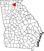
Adjacent counties:
Dawson  Fannin  Hall  Union  White  

Find in Georgia

Map of the Lumpkin County area


Our detail map of Lumpkin County shows the Lumpkin County, Georgia boundary lines and other interesting items.

Places in Lumpkin County, Georgia

  Airports     show all on map

Lumpkin County-Wimpys Airport, Mosby AHP Heliport

  Bars     show all on map

Chuck Shoals

  Bays     show all on map

Blood Mountain Cove, Penitentiary Cove

  Bridges     show all on map

Beardons Bridge, Brierpatch Bridge (historical), Castleberry Bridge, Chestatee Bridge (historical), Jay Bridge

  Buildings     show all on map

Chestatee Ranger District Office, Crown Mountain Power Plant (historical), Dahlonega - Lumpkin County Volunteer Fire Department Station 1, Dahlonega - Lumpkin County Volunteer Fire Department Station 2, Dahlonega - Lumpkin County Volunteer Fire Department Station 3, Dahlonega City Hall, Fort Benning Fire Department Station 36, Gold Museum, Lumpkin County Courthouse, Lumpkin County Detention Center, Lumpkin County Library, Lumpkin County Sheriff's Office

  Cemeteries     show all on map

Davis Chapel Cemetery, Mount Hope Cemetery

  Churches     show all on map

Antioch Church, Auraria Church, Bethlehem Church, Cane Creek Church, Cavenders Creek Church, Community Chapel Church, Concord Church, Corinth Church, Dahlonega Baptist Church, Dahlonega Church of God, Dahlonega Methodist Church, Damascus Primitive Baptist Church, Enon Church, Etowah Church, Hickory Grove Church, Hightower Church, Macedonia Church, Maranantha Church, Mill Creek Church, Mount Gilead Church, Mount Olive Church, Mount Pisgah Church, Mount Sinai Church, Mount Zion Church, New Cavender Church, New Oak Grove Church, Nimblewill Church, Old Oak Grove Church, Pecks Chapel, Philippi Church, Pleasant Grove Church, Pleasant Hill Church, Saint Pauls Church, Salem Church, Silome Church, Soules Chapel, Wahoo Church, Wesley Chapel, Yahoola Church, Zion Church, Zion Hill Church

  Cliffs     show all on map

Shellot Cliffs

  Dams     show all on map

Blackburn State Park Lake Dam, Burgess Lake Dam, Calhoun Dam (historical), Camp Glisson Dam, Camp Glisson Lower Lake Dam, Camp Glisson Upper Lake Dam, Dockery Lake Dam, Dollar Lake Dam, Etowah Number 25 Lake Dam, Etowah Number 32 Dam, Etowah Number 32 Lake Dam, Etowah River Watershed Number 25 Dam, Etowah River Watershed Number 26 Dam, Gorge Dam (historical), Hidden Lake Dam, Lake Arthur Dam, Lake Marie Dam, Majors Lake Dam, Moose Dam, Ponys Lake Dam, Ricketts Lake Dam, Rodgers Lake Dam, Whitners Lake Dam, Woody Lake Dam

  Falls     show all on map

Black Falls, Cane Creek Falls, Clay Creek Falls, DeSoto Falls

  Flats     show all on map

Chestnut Flats, Cowrock Flat

  Gaps     show all on map

Big Stamp Gap, Cane Gap, Chester Stamp Gap, Columbia Gap, Cooper Gap, Coppermine Gap, Dan Gap, Daniel Camp Gap, Deerlick Gap, Dockery Gap, Fields Gap, Gooch Gap, Gooch Gap, Grassy Gap, Ground Squirrel Gap, Hester Gap, Jacks Gap, Jarrard Gap, Justus Gap, Liss Gap, Long Gap, Low Gap, Lunsford Gap, Meadow Gap, Miller Gap, Persimmon Gap, Puncheon Gap, Shingle Mill Gap, Stonepile Gap, Tom Field Gap, Turkeypen Gap, Will Field Gap, Winding Stair Gap, Woody Gap

  Hospitals     show all on map

Chestatee Regional Hospital

  Locales     show all on map

Camp Glisson, Camp Wahsega, Chestatee Knoll Campground, Chestatee Overlook, DeSoto Falls Recreation Area, DeSoto Falls Scenic Area, Dockery Lake Campground, Harkins Mill (historical), Hawks Mountain Trail Shelter, Hidden Valley Campground, Hutcheson Mill (historical), Rock Acres Farms, Turners Campsites, Water Creek Campground, Wimpy Mill (historical), Woody Gap Campground

  Military     show all on map

Fort Dahlonega (historical)

  Mines     show all on map

Bainbridge Shaft, Barlow Cuts, Barlow Mine, Bast Cut, Battle Branch Mine, Benning Lot Mine, Betz Mine, Blackwell Shaft, Boston Cut, Bowmen Cut, Calhoun Gold Mine, Capps Prospect, Cavender Creek Mine, Chestatee Mine, Columbia Cut, Consolidated Mine, Crown Mountain Cuts, Dahlonega Quarry, Dead Horse Shaft, Etowah Mine, Findley Mine, Fishtrap Cuts, Garnet Mine, Gayden Shaft, Glassy Mine Top Mine (historical), Gold Hill Mine, Gordon Cut, Hand Cut, Hedwig-Chicago Mine, Ivy Cut, Josephine-Topabri Mine, Jumbo Mine, North Barlow Cut, Pollard Tunnel, Preacher Cut, Ralston Mine, Rogers Shaft, Singleton Cut, Tahloneka Mine, Turkey Hill Mine, Whim Hill Mine, Yahoola Cuts

  Parks     show all on map

Chestatee Wildlife Management Area, Lumpkin Company Park, Vogel State Park

  Populated Places     show all on map

Albert (historical), Auraria, Buckhorn Tavern, Burtsboro, Cane Creek, Dahlonega, Etowah (historical), Fort Smith, Garland, Gates (historical), Grace (historical), Halfway (historical), Hedwig (historical), Jay (historical), New Bridge (historical), Nimblewill, Porter Springs, Stay (historical), Tube (historical), Turners Corner, Walnut (historical), Wier (historical), Wild (historical), Willow (historical)

  Post Offices     show all on map

Dahlonega Post Office, Porter Spring Post Office (historical), Porter Springs Post Office (historical)

  Reserves     show all on map

Blood Mountain Wilderness

  Reservoirs     show all on map

Blackburn State Park Lake, Burgess Lake, Camp Glisson Lower Lake, Camp Glisson Upper Lake, Dockery Lake, Dollar Lake, Etowah 32 Lake, Etowah Number 25 Lake, Etowah Number 32 Lake, Etowah River Watershed Number 25 Lake, Etowah River Watershed Number 26 Lake, Hidden Lake, Lake Arthur, Lake Marie, Majors Lake, Ricketts Lake, Rodgers Lake, Whitners Lake, Woody Lake

  Ridges     show all on map

Bee Tree Ridge, Big Ridge, Cedar Ridge, Columbia Ridge, Findley Ridge, Horseshoe Ridge, Little Ridge, Lumpkin Ridge, Meetinghouse Ridge, Sally Free Ridge

  Schools     show all on map

Blackburn Elementary School, Cavenders Creek School, Dewey School, East Side School, Fairview School (historical), Garland School, Garnett School, Grace School, Haygood School, Hightower School, Hilltop School, Lewis School, Long Branch Elementary School, Lumpkin County Elementary School, Lumpkin County High School, Lumpkin County Middle School, Mount Pisgah School (historical), Nimblewill School (historical), North Georgia College and University, North Georgia College Farm, Oak Grove School, Wahoo School (historical), Yahoola School

  Slopes     show all on map

Tunnel Cove

  Streams     show all on map

Baggs Branch, Bells Branch, Black Branch, Blood Mountain Creek, Boggs Creek, Bryant Creek, Bull Creek, Camp Creek, Cane Branch, Cane Creek, Cavenders Creek, Chester Creek, Clay Creek, Columbia Creek, Cowrock Creek, Crooked Creek, Dennson Branch, Dicks Creek, Dowdy Branch, Dunn Branch, Edmunston Creek, Frog Call Creek, Frogtown Creek, Gab Creek, Hurricane Creek, Jarrard Creek, Jones Creek, Lance Creek, Lance Creek, Lee Creek, Left Fork Cavenders Creek, Little Cane Creek, Long Branch, Mill Creek, Mill Creek, Miller Creek, Montgomery Creek, Mooney Branch, Moose Creek, Moss Creek, Mud Creek, Nimblewill Creek, Pecks Mill Creek, Peggy Branch, Pigeon Roost Creek, Poplar Branch, Poverty Creek, Pruitt Creek, Quebec Branch, Ralston Branch, Robison Creek, Scott Branch, Tanyard Branch, Tate Creek, Tobacco Pouch Branch, Town Creek, Turner Creek, Turninglathe Branch, Two Run Creek, Walden Creek, Walker Creek, Walnut Cove Creek, Ward Creek, Ward Creek, Waters Creek, West Cane Creek, West Fork Montgomery Creek, Woody Creek, Yahoola Creek

  Summits     show all on map

Allison Mountain, Baker Mountain, Big Cedar Mountain, Black Mountain, Brushy Knob, Buck Knob, Bull Mountain, Burnett Field Mountain, Buzzard Mountain, Campbell Mountain, Cedar Mountain, Chestnut Knob, Collins Mountain, Columbia Mountain, Conner Mountain, Corbin Horse Stamp, Cowrock, Cowrock Mountain, Crow Mountain, Crown Mountain, Falls Mountain, Glass Mine Top, Granny Top, Hogback Mountain, Hogpen Mountain, Jacobs Knob, Jake Mountain, John Jones Mountain, Justus Mountain, Little Buzzard Mountain, Little Mountain, Little Sal Mountain, Miller Top, Mincle Mountain, Pigeon Roost, Porter Springs Cedar Mountain, Rock Spring Top, Rocky Mountain, Sheep Wallow Mountain, Steel Trap Knob, Three Sisters Mountain, Turkey Hill, Turkey Stamp, Turkeypen Mountain, Whim Hill, Whissenhunt Mountain, Wolf Laurel Top

  Towers     show all on map

WDGR-AM (Dahlonega)

  Trails     show all on map

DeSoto Falls Trail

  Valleys     show all on map

Bill Cove, Jim Cove, Swaim Cove, Walnut Cove,

Lumpkin County, Georgia Population By Race (2012 estimate)

RacePopulation
WhiteLumpkin County White population 29,26529,264  
MixedLumpkin County Mixed population 522522
BlackLumpkin County Black population 491491
American IndianLumpkin County American Indian population 215214
AsianLumpkin County Asian population 184184
Hawaiian & Pacific IslanderLumpkin County Hawaiian & Pacific Islander population 3130

Additional population tables :
State population table
Georgia population by county