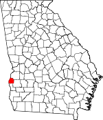
Quitman County, Georgia Basics:
Quitman County Georgia - Government Site
Population: 2,396
Area: 151 square miles
County seat: Georgetown
Area code(s) in use: 229
Time zone: EST
High school graduate or higher: 68.5%
Bachelor's degree or higher: 5.6%
Median household income: $32,750
Persons in poverty: 24.3%
Home ownership rate: 71.6%
Mean travel time to work: 21.1 minutes
Adjacent counties:
Barbour (AL) Clay Randolph Stewart
Places in Quitman County, Georgia
Richard B Russell Bridge Bumbleton Courthouse,
Georgetown City Police Department,
Quitman County Sheriff's Office,
Quitman County Volunteer Fire Department Station 1 Hogan Cemetery,
Methvin Cemetery,
Old Pataula Cemetery,
Saint Paul Cemetery Berry Chapel,
Davis Chapel,
Enon Church (historical),
Georgetown Baptist Church,
Green Grove Church,
Hopewill Church,
Liberty Church,
Morris Baptist Church,
Mount Zion Church,
Rocky Mount Church,
Saint James Church,
Saint Johns Church,
Saint Pauls Church,
Shady Grove Church,
Union Church Balkcom Lake Dam Avreys Store (historical),
Cool Branch Recreation Area,
Vandiver Causeway,
Wire Bridge River Bluff Recreation Area Crossroads,
Georgetown,
Hatcher,
Morris, Okitiyakni (historical),
Union Georgetown Post Office, Hatcher Post Office (historical), Kipling Post Office (historical), Mike Post Office (historical), Morris Post Office, Oakgrove Post Office (historical)
Balkcom Lake Keglar School,
Quitman County Elementary School Arkansas Creek,
Billy Methvin Creek,
Bustahatchee Creek,
Cool Branch,
Cotton Creek,
Crooked Creek,
Hodchodkee Creek,
Holanna Creek,
North Fork Bustahatchee Creek,
Rock Spring Branch,
Short Creek,
Smithee Jack Creek,
Soapstone Creek,
South Fork Tobannee Creek,
Still Branch,
Tobannee Creek,
Wildcat Creek,
Wolf Creek Quitman Lookout Tower,

