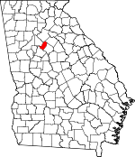
Rockdale County, Georgia Basics:


Rockdale County Georgia - Government Site

Population: 85,670
Area: 130 square miles
County seat: Conyers
Area code(s) in use: 770
Time zone: EST
High school graduate or higher: 86.7%
Bachelor's degree or higher: 25.0%
Median household income: $54,704
Persons in poverty: 13.9%
Home ownership rate: 70.7%
Mean travel time to work: 33.7 minutes


Adjacent counties:
De Kalb  Fulton  Gwinnett  Henry  Newton  Walton  

Find in Georgia

Map of the Rockdale County area


Our detail map of Rockdale County shows the Rockdale County, Georgia boundary lines and other interesting items.

Places in Rockdale County, Georgia

  Airports     show all on map

Jims Private Airport, Lola Landing Airport

  Areas     show all on map

The Rocks

  Bars     show all on map

Albert Shoals, Black Shoals, Indian Shoals

  Bridges     show all on map

Flat Bridge, Irwin Bridge, McDaniel Bridge, McKnight Bridge (historical), News Bridge, Oglesby Bridge, Pine Log Bridge, Sims Bridge

  Buildings     show all on map

Conyers City Hall, Conyers Commerce Center, Conyers Police Department, Conyers-Rockdale County Chamber of Commerce, Georgia Station Patrol Post 46 Police Station, J P Carr Gymnasium, Johnson Park Recreation Center, Nancy Guinn Library, Plantation Manor Childrens Home, Rockdale Company Station 5 Fire Station, Rockdale County Animal Shelter, Rockdale County Board of Education, Rockdale County Courthouse, Rockdale County Fire Department Station 1, Rockdale County Fire Department Station 2, Rockdale County Fire Department Station 3, Rockdale County Fire Department Station 4, Rockdale County Fire Department Station 5, Rockdale County Fire Department Station 7 Headquarters, Rockdale County Fire Department Station 8, Rockdale County Parks and Recreation Department, Rockdale County Senior Center, Rockdale County Sheriff, Sarasota Commerce Center

  Cemeteries     show all on map

Albert Cemetery, Almand Cemetery, Bonner Cemetery, Eastview Cemetery, Green Meadows Memorial Gardens, Mitchell Cemetery, Parker Cemetery, Stanley Cemetery, Whitaker Cemetery

  Census     show all on map

Lakeview Estates Census Designated Place

  Churches     show all on map

Antioch Church, Bald Rock Primitive Baptist Church, Ball Rock Church, Bethel Church, Calvary Chapel, Cedar Grove Church (historical), Church in the Now, Church of Jesus Christ, Conyers Church of Christ, Conyers Church of God, Crawford Church, Crawfordsville Baptist Church, Double Springs Church, Eastwood Church, Ebenezer Church, First Baptist Church of Conyers, First Shady Grove Baptist Church, Friendship Church (historical), Full Gospel Church, Gethsemane Baptist Church, Gethsemane Church, Haven Fellowship, Heritage Hills Baptist Church, Hi Rock Church, Hi-Roc Community Church, High View Church, Honey Creek Church, Hopewell Church (historical), Hyde Chapel, Lakeside Baptist Church, Lakeview Church, Light of Calvary Baptist Church, Lorraine Assembly of God Church, Midway Church of God, Miller Chapel, Milstead Baptist Church, Milstead United Methodist Church, Mount Olive Baptist Church, Mount Zion Church, New Hope Church, New Life Tabernacle Assembly of God Church, North Rockdale Baptist Church, Peeks Chapel, Pentecost Church, Philadelphia Church, Philadelphia Church, Pleasant Hill Christian Methodist Episcopal Church, Pleasant Hill Church, Pleasant Hill Church, Rock Temple African Methodist Episcopal Church, Rockdale Alliance Church, Rockdale Church, Rockdale Evangelical Methodist Church, Rockdale Station Number 2 Fire Station, Saint Simon's Episcopal Church, Salem Baptist Church, Shadydale Church (historical), Shepherds Door Church, Smyrna Presbyterian Church, Summer Hills Church, Sunrise Church, Tabernacle Church, True Gospel Baptist Church, Union Church, Union Grove Church, Water Oak Church, Way of the Cross Baptist Church, Westminster Church, Whites Chapel

  Crossings     show all on map

Exit 43, Interchange 40, Interchange 41, Interchange 42

  Dams     show all on map

Abbot Lake Dam, Bond Lake Dam, Carls Twin Lakes Dam, Cement Lake Dam, Coursey Lake Dam, Cousins Lake Dam, Cowan Dam, Deerun Lake Dam, Dickson Dam, East View Lake Dam, Flakes Dam, Georges Lake Dam, Hi-Roc Lake Dam, Hurst Lake Dam, Jack Turner Dam, Josephs Lake Dam, Lake Brooks Dam, Lake Capri Dam, Lake Rockaway Dam, Lees Lake Dam, Lower Alexander Lake Dam, Lower Haizlip Lake Dam, Lower Lake Capri Dam, Mann Lake Dam, Meadow Brook Dam, Monastery Lake Dam, Pine Wood Shores Lake Dam, Rockdale Lake Dam, Salem Lake Dam, Sheppards Lake Dam, Upper Alexander Lake Dam, Upper Haizlip Lake Dam, Walker Lake Dam, Weaver Lake Dam

  Hospitals     show all on map

Rockdale Medical Center

  Lakes     show all on map

Costley Millpond, Panola Lake, Parkers Lake

  Locales     show all on map

Camp Smyrna, Conyers Crossing Shopping Center, Conyers Exchange Shopping Center, Conyers Plaza Shopping Center, Conyers Square Shopping Center, Conyers Village Shopping Center, Conyers Waterworks, Costley Mill (historical), Crossroads Shopping Center, Dial Mill (historical), Elijah Mill (historical), Fieldstone Plaza Shopping Center, Gee Mill (historical), Gees Mill Business Park, Haralson Mill (historical), Heritage Village Shopping Center, Honey Creek Village Shopping Center, Hunting Creek Plaza Shopping Center, Ivy Place Shopping Center, Little Mountain Country Club, Main Street Village Shopping Center, Milstead Crossing Shopping Center, Northside Village Shopping Center, Owen Mill (historical), Park 20 East Industrial Park, Rock Mill Fish Hatchery, Rockdale Industrial Park, Rockdale Plaza Shopping Center, Rockdale Square Shopping Center, Salem Gate Shopping Center, The Hour of Deliverance Camp Ground, Tucker Mill (historical)

  Parks     show all on map

Big Haynes Creek Recreation Area, Bonner Park, Center Point Park, Eastview Park, Georgia International Horse Park, Hightower Indian Trail Monument, Johnson Park, Panola Mountain State Park, Pine Log Park, Pleasant Circle Park, Reid Memorial Stadium, Richardson Park, South Hicks Circle Park, Veal Street Park

  Populated Places     show all on map

Blossom (historical), Conyers, Eastdale Mobile Home Park, Fountain Hill (historical), Hi Roc Shores, Honey Creek (historical), Lake Capri, Lakeview Estates, Magnet, McElroys Mill, Milstead, Orleans (historical), Princeton (historical), Richardson, Sardum (historical), Velta, Zingara

  Post Offices     show all on map

Conyers Post Office, Conyers Square Post Office

  Reservoirs     show all on map

Abbot Lake, Alexander Lakes, Bond Lakes, Carls Twin Lakes, Cement Lake, Coursey Lake, Cousins Lake, Cowan Lake, Deerun Lake, Dickson Lake, Dickson Lake, East View Lake, Flakes Lake, Gaines Lake, Georges Lake, Hi-Roc Lake, Hodges Lake, Hurst Lake, Josephs Lake, Lake Brooks, Lake Brooks Dam, Lake Capri, Lake Rockaway, Lees Lake, Lower Alexander Lake, Lower Haizlip Lake, Lower Lake Capri, Mann Lake, Monastery Lake, Patrick Pond, Pine Wood Shores Lake, Randy Poynter Lake, Rockdale, Rockdale Lake, Salem Lake, Sheppards Lake, Smith Lake, Smiths Lake, Turner Lake, Ub Lake Dam, Upper Alexander Lake, Upper Haizlip Lake, Walker Lake, Walker Lake, Weaver Lake

  Schools     show all on map

Alpha Academy, Barksdale Elementary School, C J Hicks Elementary School, Cedar Grove School (historical), Conyers Apostolic Christian Academy, Conyers Church, Conyers Middle School, Crawfordville School (historical), DeKalb Technical College Rockdale Center, Ebenezer School (historical), Edwards Middle School, Flat Shoals Elementary School, General Ray Davis Middle School, Heritage High School, Hightower Trail Elementary School, Honey Creek Elementary School, J H House Elementary School, J P Carr School, Lorraine Elementary School, Magnet School (historical), Memorial Middle School, Oak Grove School (historical), Oakland School (historical), Peachtree Academy, Peachtree Academy Main Campus, Peeks Chapel Elementary School, Philadelphia Christian School, Pine Street Elementary School, Rock Hill School (historical), Rockdale Career Academy, Rockdale County High School, Rockdale Magnet School for Science and Technology, Rockdale Open Campus, Rockdale School (historical), Salem High School, Shady Grove School (historical), Shoal Creek Elementary School, Shoal Creek Elementary School, Sims Elementary School, Springs Academy, Triangle Grove School (historical), Union School (historical), Victory Christian School, Woodlee's Christian Academy, Young Americans Christian School

  Springs     show all on map

Union Spring

  Streams     show all on map

Almand Creek, Bailey Creek, Big Haynes Creek, Boar Tusk Branch, Buck Branch, Camp Creek, Carr Branch, Hammock Creek, Jackson Creek, Little Panther Creek, Mark Branch, Quigg Branch, Roberts Branch, Rock Creek, Sandy Creek, Scott Creek, Shipley Branch, Soggy Bottom Creek, Tanyard Branch, Williford Branch, Winfield Creek

  Summits     show all on map

Griffin Mountain, Panola Mountain

  Towers     show all on map

WHSG-TV (Monroe), WPBE-AM (Conyers),

Rockdale County, Georgia Population By Race (2012 estimate)

RacePopulation
BlackRockdale County Black population 41,12241,121  
WhiteRockdale County White population 40,60840,607
AsianRockdale County Asian population 1,7131,713
MixedRockdale County Mixed population 1,6281,627
American IndianRockdale County American Indian population 428428
Hawaiian & Pacific IslanderRockdale County Hawaiian & Pacific Islander population 8685

Additional population tables :
State population table
Georgia population by county