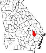
Tattnall County, Georgia Basics:


Tattnall County Georgia - Government Site

Population: 25,324
Area: 479 square miles
County seat: Reidsville
Area code(s) in use: 912
Time zone: EST
High school graduate or higher: 75.7%
Bachelor's degree or higher: 11.3%
Median household income: $36,520
Persons in poverty: 25.8%
Home ownership rate: 71.0%
Mean travel time to work: 23.8 minutes


Adjacent counties:
Appling  Candler  Emanuel  Evans  Liberty  Long  Toombs  Wayne  

Find in Georgia

Map of the Tattnall County area


Our detail map of Tattnall County shows the Tattnall County, Georgia boundary lines and other interesting items.

Places in Tattnall County, Georgia

  Airports     show all on map

Swinton Smith Field at Reidsville Municipal Airport, Tootle Airport

  Bridges     show all on map

Cow Ford Bridge, Flat Ford Bridge, Halls Bridge, Jarriel Bridge (historical), Lumber Bridge (historical), Lynn Bridge (historical), Ryals Bridge (historical), Shepards Bridge

  Buildings     show all on map

Cobbtown Fire Department, Collins District Volunteer Fire Department, Collins Police Department, Georgia State Patrol Troop F Post 18 Reidsville, Georgia State Prison, Glennville City Hall, Glennville Fire Department, Glennville Police Department, Glenvue Nursing Home, Reidsville Fire Department, Reidsville Police Department, Rogers State Prison, Smith State Prison, Tattnall County Jail, Tattnall County Sheriff's Office

  Cemeteries     show all on map

Bradley - Anderson Cemetery, Collins Cemetery, Collins Cemetery, Dowdy Cemetery, Gainwell Cemetery, Hammock Cemetery, Hammock Cemetery, Harden Cemetery, Hebron Cemetery, Holland Cemetery, Jackson Cemetery, Jerrell Cemetery, Lynn Cemetery, Maddox Cemetery, Matlock Cemetery, McArthur Cemetery, Ogden Mill Cemetery, Old Halltown Cemetery, Old Shiloh Cemetery, Old Tippins Cemetery, Padgett Cemetery, Parker Place Cemetery, Pine View Cemetery, Rewis Cemetery, Rewis Cemetery, Ryals Cemetery, Sand Hill Cemetery, Sand Hill Cemetery, Saturday Cemetery, Shady Grove Cemetery, Smith Cemetery, Stanfield Cemetery, Stripling Cemetery, Sunlight Cemetery, Surrency Cemetery, Tippins Cemetery, Waters Cemetery, Widincamp Cemetery, Wilds Cemetery, Wilkinson Cemetery

  Census     show all on map

Mendes Census Designated Place

  Churches     show all on map

Anderson Primitive Baptist Church, Battle Creek Church, Beards Creek Primitive Baptist Church, Berea Church, Bethaven Church, Bethaven Church, Beulah Church, Cedar Creek Primitive Baptist Church, Cedar Grove Church, Center of Life Fellowship Church, Charlton Grove Church, Cherry Grove Missionary Baptist Church (historical), Connors Church, Ebenezer Church, Ebenezer Church, Ella Grove Church, Elza Church, Faith Church, First Baptist Church, First Christian Church, Glennville Methodist Church, Greater Zachariah Church, Harmony Church, Hillside Church, Holiness Church (historical), Hopewell Church, Iglesia de Dios Cristo mi Roca, Kingdom Hall, Lighthouse Pentecostal Holiness Church, Little Flock Church, Love Church, Mendes Missionary Baptist Church, Mount Carmel Church, Mount Pilgrim Church, Mount Zion Church, Mount Zion Outreach Center, New Bethel Church, Northside Baptist Church, Oak Grove Missionary Baptist Church, Old Anderson Church, Pearson Chapel, Pine Grove Church, Pine Grove Church, Pine View Church, Rehoboth Baptist Church, Rehovah Church, Reidsville United Methodist Church, Roberts Chapel (historical), Rodgers Church, Rome Church, Saint Williams Church, Shiloh Church, Smyrna Church, Stony Hill Church, Sunlight Primitive Baptist Church, Watermelon Church, White Pines Church, Zaraigh Church, Zion Union Church

  Cliffs     show all on map

Moon Bluff

  Crossings     show all on map

Banards Ford, Blocker Ford, Flat Ford, Jones Ford, Long Point Ford, Pigeon Ford, Staffords Ferry (historical)

  Dams     show all on map

Big Club House Pond Dam, Callaway Pond Dam, Chicken Yard Pond Dam, Cotton Patch Pond Dam, D L Lake Dam, Dixon Lake Dam, Downstream Twin Pond Dam, Durrence Lake Dam, Gordonia Alatamaha Lake Dam, Harris Lake Dam, Hensley Lake Dam, Hodges Pond Dam, Jones Millpond Dam, Kicklighters Pond Dam, Rodgers Pond Dam, Rogers Lake Dam, Segull Lake Dam, Stones Pond Dam, Strickland Pond Dam, Surrencys Pond Dam, Upstream Twin Pond Dam, Wallace Pond Dam, Wardens Cabin Pond Dam, Waters Pond Dam, Winge Lake Dam

  Hospitals     show all on map

Tattnall Healthcare Center, The Doctors Hospital of Tattnall

  Islands     show all on map

Stooping Gum Island

  Lakes     show all on map

Bacon Pond, Bluff Lake, Jessie Lake, Stafford Lake

  Locales     show all on map

Brazell's Creek Golf Course, Collins Water Pollution Control Plant, Glennville Water Treatment Plant, Jones Millpond, Tattnall Campground

  Parks     show all on map

Big Hammock State National Recreation Area, Gordonia Alatamaha State Park, Kicks Playland

  Populated Places     show all on map

Altamaha, Alton (historical), Birdford (historical), Bradleys (historical), Cobbtown, Collins, Danton (historical), Easterling (historical), Five Points, Fort Stewart, Glennville, Hughland, Kicklighter (historical), Lynn, Manassas, Mendes, Midway, Moodys Crossing (historical), Purvis (historical), Reidsville, Tison

  Post Offices     show all on map

Glennville Post Office

  Reservoirs     show all on map

Big Club House Pond, Brewton Millpond, Brown Pond, Browns Pond, Callaway Pond, Calloway Lake, Chicken Yard Pond, Collins Pond, Cotton Patch Pond, D L Lake, Dixon Lake, Downstream Twin Pond, Durrence Lake, Durrence Pond, Durrence Pond, Edwards Millpond, Gordonia Alatamaha Lake, Groover Pond, Harris Lake, Hensley Lake, Hodges Pond, Jones Millpond, Kicklighter Pond (historical), Kicklighters Pond, Kicklighters Pond, Kicklighters Pond, Kicklighters Pond, Padgett Pond (historical), Rodgers Pond, Rogers Lake, Segull Lake, Stones Pond, Stricklands Pond, Surrencys Pond, Upstream Twin Pond, Wallace Pond, Wardins Cabin Pond, Waters Pond, Winge Lake

  Ridges     show all on map

Big Hammock

  Schools     show all on map

Appleton School (historical), Beards Creek School (historical), Bethesda School (historical), Beulah School (historical), Buck Branch School (historical), Cedar Creek School (historical), Cherry Grove School (historical), Collins Junior High School, Cow Ford School (historical), Dinner Branch School (historical), Ella Grove School (historical), Eunice School (historical), Eunice School (historical), Glennville Christian Academy, Glennville Elementary School, Glennville Middle School, Glennville Middle School, Hay Grove School (historical), Jennie School (historical), Kennedy School (historical), Matlock School (historical), Midway School, Reidsville Elementary School, Reidsville High School, Seckinger Primary School, Shiloh School (historical), Vance School (historical), Zaraigh School (historical)

  Streams     show all on map

Battle Creek, Beards Creek, Beaver Creek, Big Branch, Blocker Creek, Brazells Creek, Buck Branch, Chapel Creek, Cypress Flat Creek, Delbos Bay, Dinner Branch, Ditch Branch, Douglas Branch, Four Acre Creek, Moody Creek, Mushmelon Creek, Ohoopee River, Sandhill Creek, Slaughter Creek, Spring Branch, Thomas Creek, Watermelon Creek

  Swamps     show all on map

Dinkins Bay, Dukes Pond, Hog Lake, Padgett Bay, Sugar Bay

  Towers     show all on map

WKIG-AM (Glennville), WKIG-FM (Glennville), WRBX-FM (Reidsville), WTNL-AM (Reidsville),

Tattnall County, Georgia Population By Race (2012 estimate)

RacePopulation
WhiteTattnall County White population 17,27117,270  
BlackTattnall County Black population 7,5217,521
MixedTattnall County Mixed population 228227
American IndianTattnall County American Indian population 152151
AsianTattnall County Asian population 127126
Hawaiian & Pacific IslanderTattnall County Hawaiian & Pacific Islander population 5150

Additional population tables :
State population table
Georgia population by county