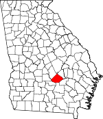
Telfair County, Georgia Basics:


Telfair County Georgia - Government Site

Population: 16,362
Area: 437 square miles
County seat: McRae
Area code(s) in use: 229 912
Time zone: EST
High school graduate or higher: 74.7%
Bachelor's degree or higher: 12.3%
Median household income: $24,469
Persons in poverty: 34.1%
Home ownership rate: 62.5%
Mean travel time to work: 20.7 minutes


Adjacent counties:
Ben Hill  Coffee  Dodge  Jeff Davis  Wheeler  Wilcox  

Find in Georgia

Map of the Telfair County area


Our detail map of Telfair County shows the Telfair County, Georgia boundary lines and other interesting items.

Places in Telfair County, Georgia

  Airports     show all on map

Fussell Airport

  Bridges     show all on map

Jacksonville Ferry Bridge

  Buildings     show all on map

Georgia State Patrol Troop F Post 16 Helena, Helena City Hall, Helena Police Department, Helena Volunteer Fire Department, Horse Creek Volunteer Fire Department, Jacksonville Volunteer Fire Department, Lumber City City Hall, Lumber City Jail, Lumber City Police Department, Lumber City Volunteer Fire Department, McRae - Helena Fire Department, McRae City Hall, McRae Correctional Institution, McRae Police Department, McRae Senior Center, Milan Police Department, Milan Volunteer Fire Department, Scotland Fire Department, Telfair Community Center, Telfair County Courthouse, Telfair County Fire Department, Telfair County Jail, Telfair County Library, Telfair County Sheriff's Office, Telfair State Prison, Telfair State Prison Fire Department

  Cemeteries     show all on map

Bethel Cemetery, Black House Cemetery, Brewer Cemetery, Browning Cemetery, Browning Cemetery, Cedar Grove Cemetery, Clark Cemetery, Dopson Cemetery, Floyd Cemetery, Graham Cemetery, Graham Cemetery, Hall Cemetery, Helena Cemetery, Hulett Cemetery, Jacksonville Cemetery, Larkey Cemetery, Livingston Cemetery, McDuffie Cemetery, McLean Cemetery, Milan City Cemetery, Mount Zion Cemetery, Oak Grove Cemetery, Powell Cemetery, Riverside Cemetery, Rockwell Cemetery, Sharon Cemetery, Shaw Cemetery, Silver Cemetery, Studstill Cemetery, Telfair Memorial Gardens, Turnpike Cemetery, Vaughn Tabernacle Cemetery, Webb Cemetery, Wilcox Cemetery, Wilcox Cemetery, Williams Cemetery, Wooten Cemetery, Wooten Cemetery

  Churches     show all on map

Bethel Church, Bethelehem Church, Blockhouse Church, Central Baptist Church, Central Grove Church, Central Valley Baptist Church, Cook Chapel, Corinth Christian Methodist Episcopal Church, Dodge Chapel, First Baptist Church, Fishing Creek Church, Frances Chapel, Friendship Church, Green Grove Church, Harmony Church, Helena Baptist Church, Helena United Methodist Church, Jacksonville United Methodist Church, James Chapel, Macedonia Church, McRae Presbyterian Church, McRae United Methodist Church, Midway Church, Mimbs Church, Mount Calvary Church, Mount Carmel Church, Mount Dolaway Church, Mount Galilee Church, Mount Zion Church, New Hope Church, New Red Hill Church, Rebecca Church, Rockhill Church, Rockwell Church, Rockwell Church, Saint James Christian Methodist Episcopal Church, Saint Pauls African Methodist Episcopal Church (historical), Saint Pauls Church, Salem Church, Sharon Church, Shelton Chapel, Siloam Church, Tabernacle Church, Temperance Church, Temple Chapel, Turnpike Church, United Church, Vaughn Tabernacle, Wesley Chapel

  Cliffs     show all on map

Coffee Bluff, Yellow Bluff

  Crossings     show all on map

Lampkins Old Field Ferry

  Dams     show all on map

Davis Pond Dam, Dobbs Lake Dam, Garrison Lake Dam, Jones Lake Dam, Lake Junan Dam, Lower Stapleton Lake Dam, Lumber City Oxidation Pond Dam, Mathews Lake Dam, Matthews Lake Dam, Mceachin Lake Dam, Powell Lake Dam, Smith Lake Dam, Stapleton Lake Dam, Stenson Lake Dam, Talmadge Lake Dam, Upper Stapleton Lake Dam, Varnadoe Lake Dam, Walker Lake Dam, Walkers Pond Dam, Williams Lake Dam

  Hospitals     show all on map

Three Rivers Hospital and Medical Center

  Lakes     show all on map

Montgomery Lake

  Locales     show all on map

Burket Ferry Landing, Cooks Still, Dodges Lake Landing, Lumber City Landing, McRae Junction, Murdock McRaes Landing, Walkers Camp

  Parks     show all on map

Little Ocmulgee State Park

  Populated Places     show all on map

Cedarpark, China Hill, Cobbville, Helena, Jacksonville, Lumber City, McRae, Milan, Neily, Scotland, Sharon, Temperance, Towns, Workmore

  Post Offices     show all on map

Helena Post Office, McRae Post Office

  Reservoirs     show all on map

Davis Pond, Dobbs Lake, Garrison Lake, Jones Lake, Lake Junan, Lower Stapleton Lake, Lumber City Oxidation Pond, Mathews Lake, Matthews Lake, Mceachin Lake, Powell Lake, Smith Lake, Spring Lake, Stapleton Lake, Stenson Lake, Talmadge Lake, Upper Stapleton Lake, Varnadoe Lake, Walker Lake, Walkers Pond, Williams Lake

  Schools     show all on map

Central School, County High School, Lumber City Elementary School, McRae Public School (historical), McRae-Helena Elementary School, McRae-Helena High School (historical), Milan Elementary School, Ocmulgee Academy, Rockhill School, South Georgia College (historical), Telfair County High School, West Telfair Academy, Workmore High School

  Streams     show all on map

Alligator Creek, Big Branch Horse Creek, Boggy Branch, Boney Creek, Cat Creek, Coffee Branch, Dopson Branch, Fishing Creek, Gregeory Creek, Griffin Creek, Gum Swamp Creek, Horse Creek, Hurricane Branch, Johnson Creek, Lampkin Branch, Little Alligator Creek, Little Horse Creek, Middle Branch Horse Creek, Mill Branch, Mill Creek, Mizell Creek, Opossum Creek, Smokehouse Branch, Turnpike Creek

  Swamps     show all on map

Buzzard Bay, Dan Bland Bay, Scott Bay, Still Bay

  Towers     show all on map

Telfair Lookout Tower, WDAX-AM (Mcrae), WDAX-FM (McRae), WMCG-FM (Milan),

Telfair County, Georgia Population By Race (2012 estimate)

RacePopulation
WhiteTelfair County White population 10,09510,095  
BlackTelfair County Black population 5,9235,923
MixedTelfair County Mixed population 164163
AsianTelfair County Asian population 115114
American IndianTelfair County American Indian population 4949
Hawaiian & Pacific IslanderTelfair County Hawaiian & Pacific Islander population 1616

Additional population tables :
State population table
Georgia population by county