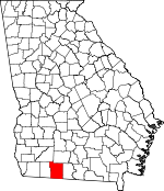
Thomas County, Georgia Basics:


Thomas County Georgia - Government Site

Population: 44,555
Area: 545 square miles
County seat: Thomasville
Area code(s) in use: 229
Time zone: EST
High school graduate or higher: 81.2%
Bachelor's degree or higher: 16.7%
Median household income: $31,471
Persons in poverty: 27.6%
Home ownership rate: 55.5%
Mean travel time to work: 20.3 minutes


Adjacent counties:
Brooks  Colquitt  Grady  Jefferson (FL)  Leon (FL)  Mitchell  

Find in Georgia

Map of the Thomas County area


Our detail map of Thomas County shows the Thomas County, Georgia boundary lines and other interesting items.

Places in Thomas County, Georgia

  Airports     show all on map

Remington Avenue Heliport, Thomasville Regional Airport, Winstead Plantation Airport

  Basins     show all on map

Howell Sinks

  Bridges     show all on map

Brumbly Bridge, Confederate Bridge, Palmer Bridge, Roup Bridge, Segler Mill Bridge, Watson Bridge

  Buildings     show all on map

Barnetts Creek Volunteer Fire Department Station 6, Barwick Volunteer Fire Department Station 3, Boston Carnegie Branch Moultrie-Colquitt County Library, Boston Fire Department Station 4, Boston Police Department, Coolidge Police Department, Dillon Volunteer Fire Department Station 7, Georgia State Patrol Troop G Post 12 Thomasville, Lake Riverside Volunteer Fire Department Station 10, Lapham-Patterson House Museum, Meigs Police Department, Meigs Volunteer Fire Department Station 9, Metcalfe Volunteer Fire Department Station 5, New Hope Volunteer Fire Department Station 14, Ochlocknee Fire Department Station 8, Pavo Police Department, Pavo Volunteer Fire Department Station 2, Reichertville Volunteer Fire Department Station 12, Sunset Volunteer Fire Department Station 1, Thomas County Courthouse, Thomas County Detention Center, Thomas County Fire Department Station 11 Coolidge, Thomas County Fire Department Station 16 Northside, Thomas County Fire Department Station 17 Southside, Thomas County Historical Museum, Thomas County Prison, Thomas County Sheriff's Office, Thomasville City Hall, Thomasville Cultural Center, Thomasville Fire and Rescue Department Station 1, Thomasville Fire and Rescue Department Station 2, Thomasville Fire and Rescue Department Station 3, Thomasville Police Department, Thomasville Public Library

  Cemeteries     show all on map

Antioch Cemetery, Antioch Cemetery, Aucilla Cemetery, Barnes Cemetery, Barnetts Creek Cemetery, Benton Cemetery, Bethlehem Cemetery, Beulah Cemetery, Beverly Cemetery, Big Creek Cemetery, Big Ochlocknee Cemetery, Blalock Cemetery, Boston City Cemetery, Carr Cemetery, Centenary Cemetery, Centennial Cemetery, Copeland Cemetery, County Line Cemetery, Dillon Cemetery, Enon Cemetery, Evergreen Cemetery, Fredonia Cemetery, Gandy Cemetery, Glasgow Cemetery, Hadley Cemetery, Hall Cemetery, Hebrew Cemetery, Hendry Cemetery, Hicks Cemetery, Horne Cemetery, Jones Cemetery, Jones Cemetery, Kennedy Chapel Cemetery, Laffittee Cemetery, Lasseter Cemetery, Laurel Hill Cemetery, Little Flock Cemetery, Little Ochlocknee Cemetery, Magnolia Cemetery, Mallette Cemetery, Martin Cemetery, McDonald Cemetery, McKinnon Cemetery, McMurray Cemetery, Midway Cemetery, Midway Cemetery, Mitchell Cemetery, Moore Cemetery, Mount Calvary Cemetery, Mount Zion Cemetery, New Hope Cemetery, Newark Community Cemetery, Ochlocknee Cemetery, Old Cemetery, Old Cemetery, Ozell Cemetery, Peaceful Rest Cemetery, Peacock Cemetery, Pebble Hill Cemetery, Pebble Hill Workers Cemetery, Pleasant Grove Cemetery, Providence Cemetery, Ramsey Cemetery, Richland Cemetery, Roddenberry Cemetery, Saint Georges Cemetery, Saint Marys Cemetery, Saint Paul Cemetery, Saint Philip Cemetery, Salem Cemetery, Shady Grove Cemetery, Singletary Cemetery Number 1, Sinkola Cemetery, Spring Hill Cemetery, Springhill Cemetery, Springhill Cemetery, Springhill Cemetery, Summerhill Cemetery, Sunset Cemetery, Sunset Memorial Gardens, Union Hill Cemetery, Vann Cemetery, Walden Cemetery, White Cemetery, White Cemetery, Williams Cemetery, Williams Cemetery, Wilson Cemetery Number 1, Wilson Cemetery Number 2

  Churches     show all on map

Altar Temple, Antioch Baptist Church, Antioch Church, Aucilla Church, Barnetts Creek Church, Bell Mission Church, Bellview Church, Bethany Congregational Church, Beulah Hill Church, Big Creek Church, Big Ochlocknee Church, Bnai Israel Synagogue, Broad Street Christian Church (historical), Cedar Hill Church, Centenary Church, Centennial Church, Central Tabernacle, Christs Sanctified Holy Church, Church of Christ, Church of God, Church of the Good Shepherd, Clifford Temple Christian Methodist Episcopal Church, Dawes Chapel, Dawson Street Baptist Church, Dawson Street Methodist Church, Dillon Church, East Side Baptist Church, Ebeneezer Church, Elam Church, Elizabeth Church, Enon Church, Evergreen Church, Fairview Methodist Church, Faith Church, First African Baptist Church, First Assembly of God Church, First Baptist Church, First Church of Christ Scientist, First Methodist Church, First Presbyterian Church, Forrest Acres Church, Fredonia Church, Friendship Church, Glasgow Church, Grace Church, Hadley Church, Holiness Church, Ireland Church, Kennedy Chapel, Kingdom Hall of Jehovahs Witnesses, Lacact Church, Little Holiness Church (historical), Little Ochlockonee Church, Macadonia Church, Maranatha Church, Meigs Baptist Church, Meigs Methodist Church, Merrillville Baptist Church, Midway Church, Midway Church, Midway Church, Mount Calvary Church, Mount Homer Church, Mount Moriah Church, Mount Olive Baptist Church, Mount Olive Church, Mount Phisby Church, Mount Pilgrim Baptist Church (historical), Mount Sinai Church, Mount Zion Church, Mount Zion Primitive Baptist Church, New Hope Church, New Hope Church, New Hope Church (historical), New Jerusalem Missionary Baptist Church, New Shiloh Church, New Zion Church, North Side Church, Oak Grove Church, Ozell Church, Paradise Church, Patten Church, Patten Church, Pleasant Grove Church, Prospect Church, Providence Church, Rebecca Church, Richland Church, Saint Augustines Roman Catholic Church, Saint Beulah Primitive Baptist Church, Saint George Church, Saint James African Methodist Episcopal Church (historical), Saint James Baptist Church, Saint Josephs Church, Saint Lukes Temple African Methodist Episcopal Church, Saint Marks African Methodist Episcopal Church, Saint Marys Church, Saint Paul Church, Saint Pauls Church, Saint Thomas African Methodist Episcopal Church, Saint Thomas Episcopal Church, Saints Temple Pentecostal Church (historical), Salem Baptist Church, Sanctum Church, Second Presbyterian Church (historical), Shady Grove Church, Simmons Hill Church, Spring Hill Church, Spring Hill Church, Spring Hill Church, Summer Hill Church, Sweetfield Church, Thomasville Primitive Baptist Church, Trinity Church, Union Hill Church, Unity Church, Westside Baptist Church, Zion Church (historical)

  Dams     show all on map

Andrews Lake Dam, Balfour Lake Dam, Bannister Lake Dam, Beverly Lake Dam, Bricknell Lake Dam, Bryan Lake Dam, Cheek Lake Dam, Cherokee Lake Dam, Greenwood Lake Dam, Griffin Lake Dam, Griffin Lake Dam, Lake Constance Dam, Madre Pond Dam, Melrose Plantation Lake Dam, Millpond Plantation Lake Dam, Mitchell Pond Dam, Powell Lake Dam, Scott Lake Dam, Searcy Lake Dam, Sevell Lake Dam, Singletary Lake Dam, Singletary Lake Dam Number Three, Singletary Lake Dam Number Two, Singletary Pond Dam, Tyler Lake Dam, Wildlife Pond Dam, Winstead Plantation Lake Dam, Womack Lake Dam

  Hospitals     show all on map

Archbold Medical Center, Archbold Urgent Care Center, Southwestern State Hospital

  Lakes     show all on map

Brileys Lake, Halls Pond, Heards Lake, McMullen Bay, Mitchell Lake, Original Pond

  Locales     show all on map

Birdwood Plantation (historical), Box Hall Plantation, Bullock Mill (historical), Galilee School, Gateway Commerce Park, Gateway Shopping Center, Glen Arven Country Club, Hollands Store, Melrose Plantation, Merrillville Poultry Farms, Metcalf Avenue Industrial Park, Pebble Hill Plantation, Pebble Way Shopping Center, Plantation Oak Industrial Park, Roddenberry Camp (historical), Rose City Industrial Park, Scullys Store (historical), Tall Pines Industrial Park, Thomasville Commerce Park, Thomasville Rose Test Gardens, Whitfield Store (historical)

  Military     show all on map

Thomasville Army Air Field (historical)

  Parks     show all on map

Dawson Street Historic District, East End Historic District, Fletcherville Historic District, Flipper Park, Gordon Avenue Historic District, Magnolia Park, McIntyre Park, Metcalfe Historic District, Paradise Park, Paradise Park Historic District, Remington Avenue Ball Parks, Thomasville Commercial Historic District, Tockwotton-Love Place Historic District, Varnedoe Station

  Populated Places     show all on map

Antioch (historical), Aucilla (historical), Barwick, Beverly (historical), Booker Heights, Boston, Chastain, Coolidge, Dawesville, Dewey City, Dillon, Eason, Enon, Everett, Five Forks, Fletcherville, Fredonia, Glasgow, Hansell, Homestead Park, Lambville (historical), McLoughlin Heights, Meigs, Merrillville, Metcalf, Mount Olive (historical), Newark, Ochlocknee, Pasco, Patten, Pebble Hill, Piscola, Quality, Roddenberry (historical), Theodore Heights, Thomasville, Touraine (historical)

  Post Offices     show all on map

Boston Post Office, Meigs Post Office, Thomasville Post Office

  Reservoirs     show all on map

Andrews Lake, Balfour Lake, Bannister Lake, Beverly Lake, Bricknell Lake, Bryan Lake, Cambest Pond, Cheek Lake, Cherokee Lake, Constance Lake, Greenwood Lake, Griffin Lake, Griffin Lake, Inwood Lake, Lake Constance, Madre Pond, Massey-Ferguson Pond, Melrose Plantation Lake, Millpond Plantation Lake, Mitchell Pond, Moodys Pond (historical), Powell Lake, Scott Lake, Searcy Lake, Sevell Lake, Singletary Lake, Singletary Lake, Singletary Lake Number Three, Singletary Pond, Turner Pond, Tyler Lake, Wildlife Pond, Wildlife Pond, Winstead Plantation Lake, Womack Lake

  Schools     show all on map

Airline School (historical), Allen Normal School (historical), Balfour School, Barnetts Creek Academy (historical), Belleview School (historical), Birdwood Junior College, Brookwood School, Centennial School (historical), Center Hill School (historical), Central High School, Children Center School, Clay Street Normal and Industrial School (historical), Douglas High School (historical), Douglas Middle School, Dunlap School, East Side Junior High School, Fletcher Institute (historical), Garrison-Pilcher School, Greenwood School (historical), Grooverville School, Harper School, Jerger School, Junior Academy, MacIntyre Park Middle School, Magnolia Junior High School, Magnolia School, McIntyre Academy (historical), Mount Moriah School, Mount Olive School (historical), Oak Hill School (historical), Patten School (historical), Pavo Elementary School, Pebble Hill School (historical), Pine Grove School (historical), Ravenwood School, Regan School (historical), Rose City School, Scott School, Sewell Vocational Center, Shelly School (historical), South Georgia College (historical), South Georgia College of Agricultural and Mechanical Arts (historical), Spring Hill School (historical), Spring Hill School (historical), Summer Hill Academy (historical), Thomas Technical School, Thomasville High School, Thomasville School, Union School, Vashti High School, Walton Technical School, Youngs Female College (historical)

  Streams     show all on map

Bailey Branch, Bay Branch, Big Branch, Big Creek, Bruces Branch, Cat Creek, Cat Creek, Connell Creek, Coon Creek, Dry Lake Creek, East Branch Barnetts Creek, Gatling Branch, Good Water Creek, Gully Branch, Hammonds Slough, Horse Creek, Little Ochlockonee River, Long Branch, Lost Creek, Masse Branch, McKeever Slough, Norton Branch, Oaky Woods Creek, Olive Creek, Oquina Creek, Pine Creek, Pine Creek, Scale Branch, Slater Branch, Titi Branch, Wards Creek, Watts Branch, Whitlock Branch, Wilson Branch

  Swamps     show all on map

Lancaster Pond, Linton Lake, Murphys Pond, Robin Bay, Stella Lake

  Towers     show all on map

WCTV-TV (Thomasville), WHGH-AM (Thomasville), WJEP-AM (Ochlocknee), WPAX-AM (Thomasville), WSTT-AM (Thomasville), WSTT-FM (Thomasville), WTUF-FM (Boston),

Thomas County, Georgia Population By Race (2012 estimate)

RacePopulation
WhiteThomas County White population 26,77826,777  
BlackThomas County Black population 16,61916,619
MixedThomas County Mixed population 579579
AsianThomas County Asian population 356356
American IndianThomas County American Indian population 223222
Hawaiian & Pacific IslanderThomas County Hawaiian & Pacific Islander population 00

Additional population tables :
State population table
Georgia population by county