Ada County, Idaho Basics:


Ada County Idaho - Government Site

Population: 408,853
Area: 1053 square miles
County seat: Boise
Area code(s) in use: 208
Time zone: MST
High school graduate or higher: 93.3%
Bachelor's degree or higher: 35.3%
Median household income: $55,499
Persons in poverty: 12.2%
Home ownership rate: 68.1%
Mean travel time to work: 19.5 minutes
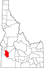
Adjacent counties:
Boise  Canyon  Elmore  Gem  Owyhee  

Find in Idaho

Map of the Ada County area


Our detail map of Ada County shows the Ada County, Idaho boundary lines and other interesting items.

Places in Ada County, Idaho

  Airports     show all on map

Boise Air Terminal, Boise Cascade Heliport, Bradley Field, Floating Feather Airport, Glider Airport, Larkin Airport, Nampa Valley Heliport, Saint Alphonsus Helistop, Saint Lukes Heliport, Strawberry Glen Airport, Young Heliport

  Beaches     show all on map

Sandy Point Beach

  Bridges     show all on map

Eagle Bridge, Linder Bridge, Star Bridge, Strawberry Glen Bridge

  Buildings     show all on map

Ada - Boi Critical Care Transfer Team, Ada County Paramedics Medical Station 51, Ada County Paramedics Medical Station 52, Ada County Paramedics Medical Station 53, Ada County Paramedics Medical Station 54, Ada County Paramedics Medical Station 56, Ada County Paramedics Medical Station 57, Ada County Paramedics Medical Station 58, Ada County Paramedics Medical Station 59, Ada County Paramedics Medical Station 60, Ada County Paramedics Medical Station 61, Ada County Paramedics Medical Station 63, Ada County Paramedics Medical Station 68, Ada County Sheriff's Office, Ada County Sheriff's Office Eagle, Boise City Fire Department Station 1, Boise City Fire Department Station 10, Boise City Fire Department Station 11, Boise City Fire Department Station 12 Region 4 Hazardous Materials Team, Boise City Fire Department Station 14, Boise City Fire Department Station 2, Boise City Fire Department Station 22, Boise City Fire Department Station 3, Boise City Fire Department Station 4, Boise City Fire Department Station 5, Boise City Fire Department Station 6, Boise City Fire Department Station 7, Boise City Fire Department Station 8, Boise City Fire Department Station 9, Boise Fire Department Aircraft Rescue Fire Fighting Unit, Boise Mounted Patrol, Boise Police Department, Boise Police Department, Boise Police Department, Boise Police Department, Boise Police Department, Boise Police Department, Boise Police Department, Boise Police Department Boise State University, Boise Police Department Headquarters, Bureau of Land Management Boise District, Bureau of Land Management Bruneau Field Office, Bureau of Land Management Four Rivers Field Office, Bureau of Land Management Idaho State Office, Eagle Fire Protection District Station 1, Eagle Fire Protection District Station 2, Eagle Fire Protection District Station 3, Eagle Island Prison Farm, Idaho Air National Guard Fire Department, Idaho Correctional Center, Idaho Elks Rehabilitation Hospital, Idaho Maximum Security Institution, Idaho Mountain Rescue Unit, Idaho State Capitol, Idaho State Correctional Institution, Idaho State Police, Idaho Transportation Department and Law Enforcement, Intermountain Hospital, Kuna Police Department, Kuna Rural Fire District, Kuna Rural Fire District Station 2, Meridian Fire Department Station 1, Meridian Fire Department Station 2, Meridian Fire Department Station 3, Meridian Fire Department Station 4, Meridian Fire Department Station 5, Meridian Police Department, North Ada County Fire and Rescue Station 1, North Ada County Fire and Rescue Station 2, North Ada County Fire and Rescue Station 3, Star Joint Fire Protection District

  Canals     show all on map

5.17 Lateral, Andrews Lateral, Ballentine Canal, Beckdolt Lateral, Bennett Lateral, Benton Lateral, Bluff Lateral, Boise City Canal, Boise Valley Canal, Boller Lateral, Bresheres Lateral, Bubb Canal, Calkins Lateral, Capitol View Canal, Carlson Lateral, Cole Lateral, Crawford Lateral, Creason Lateral, Cunningham Lateral, Downey Sublateral, Dry Creek Canal, East Fork Golden Gulch Drain, Echelberger Lateral, Eightmile Lateral, Farmers Lateral, Farmers Lateral, Farmers Union Canal, Farr Lateral, Flake Lateral, Folsom Lateral, Foothill Ditch, Gallagher Canal, Harton Davis Canal, Helm Lateral, Hon Lateral, Hubbard Lateral, Hunter Lateral, Hyatt Lateral, Karnes Lateral, Kennedy Lateral, Knudson Lateral, Kuna Canal, Lawrence Kennedy Canal, Lemberg Lateral, Lemp Canal, Leonard Lateral, Little Union Canal, Loggers Creek, Mason Creek Feeder, Mason-Catlin Canal, McBirney Lateral, McClenagan Lateral, McDonald Lateral, McHenry Lateral, Middleton Mill Canal, Milk Lateral, Moore Lateral, Mora Canal, New York Canal, Nourse Lateral, Painter Lateral, Paris Lateral, Penitentiary Canal, Penninger Lateral, Pierce Lateral, Pioneer Canal, Point Lateral, Ramsey Lateral, Rawson Canal, Rosenlof Drain, Rust Lateral, Rutledge Lateral, Settlers Canal, Seven Suckers Ditch, Shavrer Lateral, Simpson Lateral, Snider Lateral, Snyder Lateral, South Power Lateral, South Railroad Lateral, Southern Lateral, State Lateral, Stevens Lateral, Sundell Lateral, Teed Lateral, Tenmile Feeder Canal, Thomson Lateral, Threemile Lateral, Thurman Mill Canal, Tillotson Lateral, Van Duzer Lateral, Waldvogel Canal, Warm Springs Canal, West Tap Sublateral, Wilson Fruit Lateral, Wood Lateral, Zinger Lateral

  Cemeteries     show all on map

Cloverdale Memorial Park, Dry Creek Cemetery, Fairview Cemetery, Fort Boise Military Cemetery, Home of the Peace Cemetery, Idaho State Veterans Cemetery, Meridian Cemetery, Morris Hill Cemetery, Mountain View Cemetery, Pioneer Cemetery, Terrace Lawn Cemetery

  Census     show all on map

Hidden Spring Census Designated Place

  Churches     show all on map

Congregation Ahavath Beth Israel Synagogue, Fairview Church, Fivemile Community Church, McMillan Chapel, Tenmile Community Church

  Cliffs     show all on map

Bonneville Point

  Dams     show all on map

Barber Dam, Blacks Creek Dam, Boise Diversion Dam, Hubbard Dam, Lucky Peak Dam, Nicholson Dam, Orchard Dam, Swan Falls Dam

  Flats     show all on map

Henderson Flats, Slaters Flat

  Hospitals     show all on map

Boise Veterans Affairs Medical Center, Breast Cancer Detection Centers, Complex Care Hospital of Idaho, New Hope Center Hospital, Northview Hospital, Saint Alphonsus Regional Medical Center, Saint Luke's Boise Medical Center, Saint Luke's Meridian Medical Center, Saint Lukes Hospital, Southwest Idaho Advanced Care Hospital, Treasure Valley Hospital

  Islands     show all on map

Eagle Island

  Lakes     show all on map

Boise Cascade Lake, Halverson Lake, Lake Elmore, Tadpole Lake, Wind Butte Lakes

  Locales     show all on map

Barber, Barber District Ranger Station, Blacks Creek Rifle Range, Blue Valley School, Boise Towne Square, Bonneville Point Historical Site, Cherry Plaza, Clarks Ferry, Collister Shopping Center, Crane Creek Flume, Eagle Hatchery, Fairview Square, Fairwood Shopping Center, First Security Plaza, Five Mile Plaza, Franklin Towne Center, Green Meadows School, Hickey, Hillcrest Country Club, Hillcrest Plaza, Idaho State Correctional Institution, Indian Creek Reservoir Public Fishing Area, Lucky Peak Forest Nursery, Milwaukee Shopping Center, Northgate Shopping Center, Old Boise Plaza, Orchard Ranch (historical), Pleasant View School, Sheep Creek Access Area, T J Maxx Plaza, Tenmile Rodeo Grounds, Thurman Mill, Upper Fairview School, Valley View School, Vista Village Shopping Center, West State, Western Idaho Fairgrounds, Westgate Mall, White Cross School

  Military     show all on map

Boise Air Terminal Air Guard Station

  Mines     show all on map

Adelmann Mine, Black Hornet Mine, Queen Mine

  Parks     show all on map

Aldape Park, Ann Morrison Park, Ayres Park, Barclay Bay Picnic Area, Bowden Park, Camelsback Park, Discovery Picnic Area, Eagle Island State Park, Elm Grove Park, Fairview Park, Fort Boise Park, Ivywild Park, Julia Davis Park, Lucky Peak State Recreation Area, McCauley Park, Noble Park, Sunset Park, Veterans Memorial State Park, Winstead Park

  Pillars     show all on map

Table Rock Cross

  Populated Places     show all on map

Barber, Beatty, Blacks (historical), Blacks Creek, Boise, Boise Hills Village, Boise Junction, Cloverdale, Collister, Eagle, Garden City, Highlands, Hillcrest, Kuna, Leone, Meridian, Mora, Neal (historical), Orchard, Owyhee, Perkins, Pleasant Valley, Regina, Sonna, South Boise (historical), Star, Swan Falls, Ustick, Vernon

  Reserves     show all on map

Boise River Wildlife Management Area

  Reservoirs     show all on map

Blacks Creek Reservoir, Hubbard Reservoir, Indian Creek Reservoir, Lucky Peak Lake

  Schools     show all on map

Ada County Juvenile Center, Adams Elementary School, Amity Elementary School, Amity School, Bible College, Bishop Kelly High School, Boise Christian School, Boise Senior High School, Boise State University, Boise Valley Adventist School, Booth Memorial School, Borah Senior High School, Campus School, Capital Senior High School, Carden School of Boise, Centennial High School, Chief Joseph Elementary, Cole Elementary School, Cole-Christian School, Collister Elementary School, Columbia School, Cynthia Mann Elementary School, Eagle Elementary School, Eagle Hills Elementary School, East Junior High School, Fairmont Junior High School, Fort Boise Learning Center, Franklin Elementary School, Frontier Elementary School, Garfield Elementary School, Good Shepherd Lutheran Preschool and Kindergarten, Hawthorne Elementary School, High Line School, Highlands Elementary School, Hillcrest Elementary School, Hillside Junior High School, Horizon Elementary School, Hubbard Elementary School, Intermountain Hospital School, Jackson Elementary School, Jefferson Elementary School, Joplin Elementary School, Koelsch Elementary School, Kuna Indian Creek Elementary School, Kuna Junior High School, Kuna Senior High School, Lake Hazel Elementary School, Lake Hazel Middle School, Liberty Elementary School, Lincoln School, Linder Elementary School, Locust Grove School, Longfellow Elementary School, Lowell Elementary School, Lowell Scott Middle School, Lower Fairview School, Madison Elementary School, Maple Grove Elementary School, Maple Grove School, Maranatha Christian Schools, Mary McPherson Elementary School, McKinley Elementary School, McMillan Elementary School, Meridian Alternative School, Meridian Elementary School, Meridian High School, Meridian Middle School, Monroe Elementary School, Mountain View Elementary School, North Junior High School, Northwest Passages Adolescent Hospital Special School, Owyhee Elementary School, Pierce Park Elementary School, Pioneer Elementary School, Prickett School, Ridgewood Elementary School, Riverside Elementary School, Roosevelt Elementary School, Roosevelt School, Ross Elementary School, Sacred Heart School, Saint Josephs School, Saint Marys School, Silver Sage Elementary School, South Junior High School, Star Elementary School, Summerwind Elementary School, Taft Elementary School, The Childrens School, The Elementary Montessori School, Ustick Elementary School, Valley View Elementary School, Washington Elementary School, West Boise Junior High School, White Pine Elementary School, Whitney Elementary School, Whittier Elementary School

  Springs     show all on map

Terteling Springs

  Streams     show all on map

Big Gulch Creek, Birch Creek, Blacks Creek, Bowns Creek, Bryans Run, Charcoal Creek, Cottonwood Creek, Council Spring Creek, Crane Creek, Currant Creek, Daniels Creek, Dry Creek, Eightmile Creek, Fivemile Creek, Freestone Creek, Goose Creek, Indian Creek, Little Charcoal Creek, Little Gulch Creek, Mason Creek, McFarland Creek, Ninemile Creek, North Fork Daniels Creek, North Indian Creek, North Slough, Picket Pin Creek, Sand Creek, Sheep Creek, Sheep Creek, Shingle Creek, South Fork Daniels Creek, South Fork Robie Creek, South Slough, Spring Valley Creek, Threemile Creek, Warm Springs Creek

  Summits     show all on map

Aldape Summit, Big Foot Butte, Christmas Mountain, Cinder Cone Butte, Coyote Butte, Flagstaff Butte, Highland Valley Summit, Initial Point, Kepros Mountain, Kuna Butte, Little Joe Butte, Lucky Peak, Shaw Mountain, Table Rock, Wind Butte

  Towers     show all on map

KBOI-AM (Boise), KFXD-AM (Nampa), KGEM-AM (Boise), KIDO, KIDO-AM (Boise), KKIC-AM (Boise), KLIT-AM (Meridian), KSGR-AM (Nampa), KSPD-AM (Boise), KUCL-AM (Boise), KUCL-AM (Boise)

  Trails     show all on map

Hulls Gulch Nature Trail

  Valleys     show all on map

Boise Valley, Caldwell Draw, Crane Gulch, Curlew Gulch, Dry Creek Valley, Highland Valley, Hulls Gulch, Isaacs Canyon, Jackass Gulch, Lydle Gulch, Maynard Gulch, McElroy Draw, Miller Gulch, Orchard Gulch, Pierce Gulch, Pipeline Gulch, Polecat Gulch, Purdam Gulch, Rocky Canyon, Sams Gulch, Sand Hollow, Schoonover Gulch, Seaman Gulch, Spring Valley, Stewart Gulch, Turner Gulch, Woods Gulch,

Ada County, Idaho Population By Race (2012 estimate)

RacePopulation
WhiteAda County White population 378,189378,189  
AsianAda County Asian population 11,03911,039
MixedAda County Mixed population 10,22110,221
BlackAda County Black population 4,9064,906
American IndianAda County American Indian population 3,6803,679
Hawaiian & Pacific IslanderAda County Hawaiian & Pacific Islander population 818817

Additional population tables :
State population table
Idaho population by county