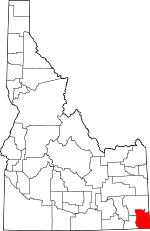
Bear Lake County, Idaho Basics:


Bear Lake County Idaho - Government Site

Population: 5,904
Area: 975 square miles
County seat: Paris
Area code(s) in use: 208
Time zone: MST
High school graduate or higher: 90.5%
Bachelor's degree or higher: 13.8%
Median household income: $40,242
Persons in poverty: 15.4%
Home ownership rate: 80.9%
Mean travel time to work: 19.7 minutes


Adjacent counties:
Cache (UT)  Caribou  Franklin  Lincoln (WY)  Rich (UT)  
Find in Idaho

Map of the Bear Lake County area


Our detail map of Bear Lake County shows the Bear Lake County, Idaho boundary lines and other interesting items.

Places in Bear Lake County, Idaho

  Airports     show all on map

Bear Lake County Airport

  Areas     show all on map

Bear Lake Plateau, Bennetts Grove, Hellhole

  Basins     show all on map

Cheatbeck Basin, Copenhagen Basin, Green Basin, Horsehoe Basin, Mahogany Basin, Rattlesnake Basin, The Hole

  Buildings     show all on map

Bear Lake County Ambulance, Bear Lake County Sheriff's Office, Bear Lake Volunteer Fire Protection District Station 1, Bear Lake Volunteer Fire Protection District Station 10, Bear Lake Volunteer Fire Protection District Station 11, Bear Lake Volunteer Fire Protection District Station 12, Bear Lake Volunteer Fire Protection District Station 14, Bear Lake Volunteer Fire Protection District Station 2, Bear Lake Volunteer Fire Protection District Station 3, Bear Lake Volunteer Fire Protection District Station 4, Bear Lake Volunteer Fire Protection District Station 5, Bear Lake Volunteer Fire Protection District Station 6, Bear Lake Volunteer Fire Protection District Station 8, Bear Lake Volunteer Fire Protection District Station 9, Montpelier Fire Department, Montpelier Police Department

  Canals     show all on map

Bear Lake Outlet, Black Otter Canal, Cook Canal, Etcheverry Ditch, Geneva Ditch, Halls Ditch, Kent La Roco Canal, Kent LaRoco Canal, Miller Ditch, Montpelier Preston Canal, Nuffer Canal, Peg Leg Ditch, Rainbow Canal, Raymond Canal, Ream Crockett Canal, Steven Larson Ditch, Taylor Canal

  Capes     show all on map

Harer Point

  Cemeteries     show all on map

Dingle Cemetery, Geneva Cemetery, Lanark Cemetery, Liberty Cemetery, Nounan Cemetery, Ovid Cemetery, Raymond Cemetery, Skinner Cemetery

  Census     show all on map

Bennington Census Designated Place

  Cliffs     show all on map

Snowside Point

  Dams     show all on map

Fife Dam, Gardiner-Lower Dam, Gardiner-Upper Dam, Hammond Dam, Montpelier Creek Dam, Rainbow Dam, Red Pine Canyon Dam, Sheep Creek Dam, Stewart Dam, Welling Number Two Dam

  Flats     show all on map

Danish Flat, Fox Flat, Horse Flat, Moonlight Meadow, Paris Flat, Pine Flat, Telegraph Flat, Whiskey Flat

  Gaps     show all on map

Georgetown Summit, Green Pass, Joes Gap, Pine Gap, White Pass

  Hospitals     show all on map

Bear Lake Memorial Hospital

  Lakes     show all on map

Bartlett Lake, Bloomington Lake, Limekiln Lake, Merkley Lake, Midnight Lake, Mud Lake, Ranger Dip, Swan Lake, Worm Lake

  Locales     show all on map

Camp Ho-Nok, Cavanaugh Siding, Cold Spring Campground, Davis Canyon Recreation Site, Dingle, Eightmile Campground, Eightmile Ranger Station, Emigration Campground, G H Hall Ranch, Georgetown, Home Canyon Campground, Landmark Letter, Montpelier Canyon Campground, Montpelier Shopping Center, Mumford Ranch, Pescadero Siding, Saint Charles Campground, Saint Charles Creek Fish Trap, Sugarloaf, Summit View Campground, Taylor Meadow, The Dell, Whitman Hollow Campground

  Mines     show all on map

Blackstone Mine, Boulder Mine, Clark Mine

  Parks     show all on map

Bear Lake National Wildlife Refuge, North Beach State Park, Stock Park

  Populated Places     show all on map

Alton, Bear Lake Hot Springs, Bear Lake Sands, Bennington, Bern, Bloomington, Border, Chausse, Dingle, Fish Haven, Geneva, Georgetown, Giveout, Glencoe, Harer, Lanark, Liberty, Lifton, Lindsayville, Manson, Montpelier, Nounan, Novene, Ovid, Paris, Pegram, Raymond, Saint Charles, Sharon, Turnpike, Wardboro, Wooleys

  Ranges     show all on map

Bear River Range, Sheep Creek Hills

  Reserves     show all on map

Dingle Swamp Wildlife Habitat Area, Georgetown Summit Wildlife Management Area, Montpelier Wildlife Management Area

  Reservoirs     show all on map

Cranes Reservoir, Fife Reservoir, Little Valley Reservoir, Montpelier Reservoir, Mud Lake, Sheep Creek Reservoir

  Ridges     show all on map

Boundary Ridge, Dairy Ridge, Dry Ridge, Hogsback Ridge, Lake Ridge, Mahogany Ridge, Pine Spring Ridge, Poulsen Ridge

  Schools     show all on map

A J Winters Elementary School, Bear Lake High School, Bear Lake Junior High School (historical), Bear Lake Middle School, Eightmile School, Emerson School, Geneva Elementary School, Georgetown Elementary School, Paris Elementary School

  Springs     show all on map

Aspen Spring, Bailey Creek Spring, Balsam Spring, Bennetts Spring, Big Canyon Spring, Big Spring, Blue Pond Spring, Burnt Spring, Camp Spring, Coby Spring, Corduroy Spring, Crib Spring, Crystal Spring, Dune Spring, Emigration Spring, Fox Spring, Goodhart Spring, Green Canyon Spring, Green Pass Spring, Hoopgobel Spring, Huckleberry Spring, Humberg Spring, Jarvis Spring, Jensen Spring, Left Fork Fish Haven Spring, Little Joe Spring, Little Spring, Log Spring, Mahogany Basin Spring, Maple Canyon Spring, Miles Canyon Spring, Nieber Spring, Paris Spring, Pine Spring, Red Pine Spring, Red Pine Spring, Rock Spring, Sadducee Spring, Sago Spring, Saint Charles Spring, Sherma Spring, Steep Spring, Thompson Spring, Trail Spring, Trouble Spring, Willow Flat Spring, Willow Patch Spring, Willow Spring, Worm Creek Spring

  Streams     show all on map

Bailey Creek, Beaver Creek, Beaver Creek, Big Creek, Bloomington Creek, Christy Creek, Co-Op Creek, Cow Fork Eightmile Creek, Dip Creek, Dry Creek, Dry Creek, Dry Fork, Eightmile Creek, Emigration Creek, Fern Creek, Fish Creek, Fish Haven Creek, Georgetown Creek, Hammond Creek, Horse Creek, Indian Creek, Left Fork, Liberty Creek, Limekiln Fork, Little Beaver Creek, Little Creek, Meadow Creek, Middle Fork Bloomington Creek, Mill Creek, Mill Fork Eightmile Creek, Montpelier Creek, Ninemile Creek, North Creek, North Fork Bloomington Creek, North Pearl Creek, North Skinner Creek, North Stauffer Creek, North Wilson Creek, Ovid Creek, Paris Creek, Pearl Creek, Pegram Creek, Pine Spring Creek, Preuss Creek, Raymond Creek, Saint Charles Creek, Shale Creek, Sheep Creek, Skinner Creek, Snyder Creek, Sotter Creek, South Fork Bloomington Creek, South Skinner Creek, South Stauffer Creek, South Wilson Creek, Spring Creek, Spring Creek, Stauffer Creek, Stewart Fork, Sweetwater Creek, Taylor Creek, Thomas Fork, Threemile Creek, Trail Creek, Twin Spring Creek, Water Fork, West Fork Sheep Creek, Whiskey Creek, Worm Creek

  Summits     show all on map

Bald Mountain, Bloomington Peak, Border Summit, Geneva Summit, Harrington Peak, Hawks Peak, Meade Peak, Merkley Mountain, Midnight Mountain, Paris Peak, Shale Point, Sherman Peak, Soda Peak, South Hill, Table Mountain, Threemile Peak

  Swamps     show all on map

Dingle Swamp

  Towers     show all on map

KVSI-AM (Montpelier)

  Trails     show all on map

Midland Trail

  Valleys     show all on map

Aegetter Hollow, Bagley Hollow, Balsam Hollow, Banks Valley, Bear Hollow, Bear Hollow, Bear Hollow, Bear Lake Valley, Bee Hunt Hollow, Bennington Canyon, Big Canyon, Bischoff Canyon, Bunney Gulch, Cabin Hollow, Cart Hollow, Chokecherry Hollow, Church Hollow, Cooley Canyon, Copenhagen Canyon, Cow Hollow, Crossley Hollow, Dairy Hollow, Dam Hollow, Davis Canyon, Deep Hollow, Dry Canyon, Dry Canyon, Dry Canyon, Dud Hollow, Dunns Canyon, Dutch Canyon, Emigration Canyon, Findlay Hollow, First Hollow, First Hollow, Fish Haven Canyon, Fisher Hollow, Fourth Hollow, French Hollow, Georgetown Canyon, Gertch Canyon, Grandy Hollow, Grant Canyon, Green Canyon, Grunder Hollow, Hardscrabble Canyon, Harrys Hollow, Hawks Roost, Home Canyon, Honeycomb, Horse Valley, Jack Hollow, Jacobs Canyon, Jones Canyon, Lateral Canyon, Ledge Hollow, Left Fork Fish Haven Canyon, Left Fork Maple Canyon, Left Hand Fork Georgetown Canyon, Little Canyon, Little Rolph Canyon, Little Threemile Canyon, Maple Canyon, Maple Canyon, Mercham Hollow, Middle Fork North Canyon, Middle Fork South Canyon, Miles Canyon, Mill Hollow, Mill Hollow, Montpelier Canyon, Morgan Canyon, North Canyon, Nounan Valley, Paris Canyon, Peter Hollow, Peterson Hollow, Phosphoria Gulch, Pine Canyon, Poison Hollow, Pole Canyon, Porcupine Hollow, Rattlesnake Canyon, Red Canyon, Red Pine Canyon, Red Pine Hollow, Red Pine Hollow, Red Rock Canyon, Rich Hollow, Right Fork Fish Haven Canyon, Right Fork Maple Canyon, Right Hand Fork Georgetown Canyon, Rolph Canyon, Rowley Canyon, Sadducee Hollow, Sago Hollow, Saint Charles Canyon, Sams Hollow, Second Hollow, Second Hollow, Sheep Hollow, Sleight Canyon, Snowside Canyon, South Canyon, South Elbow Hollow, South Fork North Canyon, South Fork Paris Canyon, South Fork South Canyon, Spring Hollow, Spring Hollow, Surnge Canyon, Swine Bend Hollow, Telegraph Hollow, Telephone Draw, Third Hollow, Third Hollow, Thomas Fork Valley, Trail Hollow, Transtrum Hollow, Tubbs Hollow, West Elbow Hollow, White Pine Canyon, Whitman Hollow, Williamson Hollow, Wills Canyon, Wood Canyon,

Bear Lake County, Idaho Population By Race (2012 estimate)

RacePopulation
WhiteBear Lake County White population 5,7685,768  
MixedBear Lake County Mixed population 5353
American IndianBear Lake County American Indian population 4141
AsianBear Lake County Asian population 2423
BlackBear Lake County Black population 1817
Hawaiian & Pacific IslanderBear Lake County Hawaiian & Pacific Islander population 00

Additional population tables :
State population table
Idaho population by county