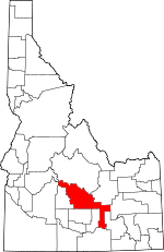
Blaine County, Idaho Basics:


Blaine County Idaho - Government Site

Population: 21,141
Area: 2644 square miles
County seat: Hailey
Area code(s) in use: 208
Time zone: MST
High school graduate or higher: 90.5%
Bachelor's degree or higher: 44.0%
Median household income: $60,160
Persons in poverty: 8.9%
Home ownership rate: 68.1%
Mean travel time to work: 17.5 minutes


Adjacent counties:
Bingham  Boise  Butte  Camas  Cassia  Custer  Elmore  Lincoln  Minidoka  Power  
Find in Idaho

Map of the Blaine County area


Our detail map of Blaine County shows the Blaine County, Idaho boundary lines and other interesting items.

Places in Blaine County, Idaho

  Airports     show all on map

Bear Trap Airport, Carey Airport, Coxs Well Airport, Flat Top Airstrip, Friedman Memorial Airport, Gimlet Airport, Hollow Top Airport, Picabo Airport, Sluder Airstrip, Smiley Creek Airport

  Areas     show all on map

Craters of the Moon, Sisters Grove

  Bars     show all on map

Rocky Bar

  Basins     show all on map

Big Basin, Boulder Basin, Little Basin

  Bridges     show all on map

Kilpatrick Bridge, Pagari Bridge

  Buildings     show all on map

Bellevue Fire Department, Blaine County Sheriff's Office, Carey Rural Fire Protection District, Hailey Fire Department, Hailey Police Department, Ketchum Fire Department Station 1, Ketchum Fire Department Station 2, Ketchum Fire Department Station 3, Ketchum Police Department, Sun Valley Fire Department, Sun Valley Fire Department, Sun Valley Police Department, Wood River Fire Protection District Station 1, Wood River Fire Protection District Station 2, Wood River Fire Protection District Station 3

  Canals     show all on map

Bellevue Canal, Buhler Drain, Butte Creek, Bypass Canal, Canal Number 45, Comstock Ditch, Cove Canal, District Canal, District Canal Forty-Five, East Canal, Emma Canal, Hiawatha Canal, High Line Canal, Highline Ditch, Justus Ditch, Kilpatrick Ditch, Lateral C 6, Lawson Ditch, Mizer Ditch, Pole Creek Ditch, Stanfield Ditch, West Canal

  Capes     show all on map

Myrtle Point

  Cemeteries     show all on map

Bellevue Cemetery, Carey Cemetery, Galena Pioneer Cemetery, Sawtooth Cemetery, Timmerman Cemetery

  Cliffs     show all on map

Crown Point

  Craters     show all on map

Bowl Crater, Snowdrift Crater

  Dams     show all on map

Albrethsen Dam, Albrethsen Dam, Campbell Dam, Clarendon Hot Springs Dam, Fish Creek Dam, Howard Dam, Little Wood Dam, Magic Dam, Pettit Lake Fish Barrier Dam, Sonner Dam, Trail Creek Dam

  Flats     show all on map

Bear Park, Burgess Flats, Camas Flats, Campbell Flats, Fort Hall Bottoms, Gilman Flat, Jasper Flats, Josper Flats, Litte Park, Little Laidlaw Park, Mahoney Flat, Paddelford Flat, Placer Flat, Poison Flat, Poverty Flat, Rye Grass Flat, Sky Ranch Flat, Sonners Flat, Spud Patch Flat

  Gaps     show all on map

Bradley Summit, Hollow Top, Johnstone Pass, Muldoon Summit, P K Pass

  Hospitals     show all on map

Saint Luke's Wood River Medical Center

  Islands     show all on map

Bird Island, McTucker Island

  Lakes     show all on map

Alice Lake, Alturas Lake, Amber Lakes, Antelope Lake, Baker Lake, Baldwin Lake, Big Lost Lake, Binder Lake, Boulder Lakes, Bullshot Reservoir, Crossroad Lake, District Boundary Lake, Dollar Lake, Gentle Horse Lake, Governors Punchbowl, Hillside Lake, Huff Lake, Indian Lake, King Lakes, Lake Creek Lakes, Lava Lake, Little Lost Lake, Lower Box Canyon Lake, Martin Lake, Mill Lake, Miner Lake, Moran Lake, Mud Lake, Norton Lakes, Notch Lake, Packsaddle Lake, Paddelford Flat Lake, Penny Lake, Perkins Lake, Pettit Lake, Prairie Lakes, Quigley Pond, Rattlesnake Water Hole Number One, Rattlesnake Water Hole Number Two, Road Lake Waterhole, Rock Lake, Sage Lake, Silver Lake, Smoky Lake, South Lake, Spencer Lake, Split Butte Lake, Square Lake, Student Lake, Sullivan Lake, Tapper Lake, The Narrows, Titus Lake, Twin Lakes, Twin Lakes, Two Bottom Lake, Upper Box Canyon Lake, Weigle Pond, Wild Horse Lake, Wildhorse Lake, Window Lake, Windy Lake

  Lava     show all on map

Bear Trap Lava Tube, Fissure Butte Flows, Sawtooth Flow, Sentinel West Flow, Sheep Trail Butte East Flow, Sheep Trail Butte Southeast Flow, Vermilion Chasm Flow

  Locales     show all on map

Alturas Inlet Campground, Apache Mill, Baker Creek Campground, Baker Creek Campground, Balaam, Beaver Creek Store, Blaine County Fairgrounds, Boundary Campground, Bridge Campground, Bridge of the Moon, Camp Manapu, Camp Perkins, Camp Sawtooth, Central Idaho Camp, Colonnade Mall, Columbia Sawmill (historical), Copper Creek Camp, Cottonwood Campground, Deer Creek Campground, Deer Creek Ranch, Federal Gulch Campground, Fish Creek Reservoir Access Area, Galena Overlook, Garfield Forest Service Station, Giacobbi Square, Greenhorn Guard Station, Halfway House, Hayspur Fish Hatchery, Hot Springs Landing, Hot Springs Ranch, Huff Creek Corral, Hyndman Campground, Laidlaw Park Holding Corral, Lake Alturas Lodge, Lava Point Access Area, Luther Heights Camp, Moonstone Access Area, Moonstone Landing, Muldoon, Murdock Campground, North Fork Campground, North Shore Campground, Pioneer Cabin, Point of Rocks, Pole Creek Guard Station, Prairie Campground, Rock Creek Ranch, Rooks Creek Campground, Rowley Ranch, Russian John Guard Station, Sawmill Campground, Sawtooth National Recreation Area Headquarters, Silver Creek Access Area, Smilty Creek Lodge, Smokey Bear Campground, Smoky Bear Lodge, Stanton Crossing Access Area, Stewart Ranch, Sun Valley Village, Swinging Bridge, Vienna, Warm Springs Campground, Wolftone Campground, Wood River Campground

  Mines     show all on map

Amicus Mine, Camas Mine, Climax Mine, Courier Mine, Croesus Mine, Democrat Mine, Drummond Mine, Eagle Bird Mine, Golden Star Mine, Hope Mine, Idaho Muldoon Mine, Independence Mine, June Day Mine, Liberty Gem Mine, Lucky Gulch Mine, Mascot Mine, McCoy Mine, Minnie Moore Mine, Montgomery Mine, Muldoon Mine, Mutual Mine, North Star Mine, Old Triumph Mine, Parker Mine, Paymaster Mine, Pierce Tunnel, Red Cloud Mine, Red Elephant Mine, Saint Louis Mine, Silver King Mine, Silver Star Queen, Snoose Mine, Solace Mine, Sunshine Mine, Tip Top Mine, Treasure Vault Mine, Triumph Mine, Uhrig Mine, Vienna Mine, Webfoot Mine

  Parks     show all on map

Baker Creek Picnic Area, Craters of the Moon National Preserve, Deer Creek Picnic Area

  Pillars     show all on map

Bell Rock, Castle Rock, Horse Collar Rock

  Populated Places     show all on map

Barite, Bellevue, Boulder, Broadford, Bullion, Carey, Cathedral Pines, Clarendon Hot Springs, Cream Can Junction, DeWoff, Doniphan, Easley Hot Springs, Elkhorn Village, Galena, Gannett, Gimlet, Hailey, Hawley, Ketchum, Leduc (historical), Magic City, Magic Resort, Picabo, Sawtooth City (historical), Smith Springs, Stanton Crossing, Sun Valley, Tikura, Triumph, Wapi

  Post Offices     show all on map

Doniphan Post Office (historical), Leslie Post Office (historical)

  Ranges     show all on map

Lake Hills, Picabo Hills, Pioneer Mountains, Sawtooth Range, Smoky Mountains, Timmerman Hills

  Reserves     show all on map

Carey Lake Wildlife Management Area, Sikes Act Wildlife Habitat Area, Wood River Deer Migration Corridor

  Reservoirs     show all on map

Blowout Reservoir, Bowl Reservoir, Cameron Reservoir, Campbell Reservoir, Carey Lake, Carpenter Reservoir, Carraway Reservoir, Clear Lake Reservoir, Corner Reservoir, Culvert Reservoir, Deadhorse Reservoir, Erwin Reservoir, Fish Creek Reservoir, Gerity Reservoir, Harris Reservoir, Hawk Reservoir, Hiway Reservoir, Houghland Reservoir Number 1, Houghland Reservoir Number 2, Howard Reservoir, Junction Reservoir, Linda Reservoir, Little Wood River Reservoir, Lulu Reservoir, Magic Reservoir, Moline Reservoir, Monument Reservoir, North Blowout Reservoir, North Pole Lake, Northside Reservoir, Poverty Flat Reservoir, Purdy Reservoir, Reservoir Number Ninety-Three, Sand Lake Reservoir, Section Eight Reservoir, Snowdrift Reservoir, Sonners Reservoir, Trestle Reservoir, Wheatly Pond, Zada Reservoir

  Ridges     show all on map

Cowcatcher Ridge, Dinosaur Ridge, Duncan Ridge, Morgan Ridge, Muldoon Ridge, Wind Ridge

  Schools     show all on map

Bellevue Primary School, Carey Public School, Ernest Hemingway Elementary, Glendale School, Hailey Elementary School, Wood River High School, Wood River Middle School

  Springs     show all on map

Antler Spring, Arrowhead Spring, Arrowhead Spring Number Two, Aspen Spring, Bannon Spring, Barrel Spring, Barrel Springs, Billingsley Spring, Calhoun Spring, Chokecherry Spring, Clay Bank Spring, Cove Spring, Deer Mountain Spring, Deerhorn Spring, Ditch Spring, Eagle Spring, Elk Spring, Guyer Hot Springs, Hailey Hot Springs, Italian Spring, Last Chance Springs, Leduck Canyon Spring, Mandolin Spring, Martin Spring, Mud Springs, North Queens Crown Springs, Pasco Spring, Picabo Town Spring, Red Rock Spring, Roseberry Springs, Sagebrush Spring, Shady Spring, Shirley Spring, Spud Patch Spring, Strode Spring, Sunset Spring, Timber Butte Spring, Timmerman Spring, Tipton Spring, Warfield Hot Spring, Watercress Spring, Wurst Spring

  Streams     show all on map

Alpine Creek, Anderson Creek, Antelope Creek, Apollo Creek, Argosy Creek, Baker Creek, Baugh Creek, Beaver Creek, Big Jimmy Creek, Big Witch Creek, Black Slough, Boulder Creek, Brock Creek, Brown Creek, Buck Creek, Buckhorn Creek, Burgess Creek, Burks Creek, Butterfield Creek, Button Creek, Cabin Creek, Cabin Creek, Cain Creek, Camp Creek, Camp Creek, Castle Creek, Chalmplain Creek, Chaney Creek, Chaparral Creek, Cherry Creek, Chicken Creek, Chicken Creek, Chukar Creek, Cinnamon Creek, Clear Creek, Cold Spring Creek, Copper Creek, Copper Creek, Corral Creek, Cottonwood Creek, Cove Creek, Cove Creek, Cow Creek, Coyote Creek, Crooks Creek, Croy Creek, Crystal Creek, Danielson Creek, Deadman Creek, Deer Creek, Diggie Creek, Dip Creek, Dip Vat Creek, Dooley Creek, Dry Creek, Dry Creek, Eagle Creek, Eagle Creek, Easley Creek, East Fork Baker Creek, East Fork Castle Creek, East Fork Dip Vat Creek, East Fork Dry Creek, East Fork North Fork Big Wood River, East Fork Rock Creek, East Fork Wood River, Elk Creek, Enclosure Creek, Finley Creek, Fish Creek, Flat Creek, Fox Creek, Frenchman Creek, Gibson Drain, Gladiator Creek, Goat Creek, Grays Creek, Greenhorn Creek, Grove Creek, Hailey Creek, High Five Creek, Horn Creek, Horse Creek, Huff Creek, Hyndman Creek, Indian Creek, Iron Mine Creek, Iron Mine Creek, Jimmie Creek, Johnstone Creek, Kale Creek, Kerf Creek, King Creek, Kinsey Creek, Konrad Creek, Laidlaw Creek, Lake Creek, Lake Creek, Lane Creek, Left Fork Placer Creek, LeMoyne Creek, Leroux Creek, Little Baugh Creek, Little Beaver Creek, Little Copper Creek, Little Poison Creek, Little Rock Creek, Little Thompson Creek, Loving Creek, Mahoney Creek, Mandolin Creek, McTucker Creek, Meadow Creek, Middle Fork Warm Springs Creek, Mill Creek, Moran Creek, Mud Creek, Mud Slough, Mud Springs Creek, Muldoon Creek, Murdock Creek, Newman Creek, North Cherry Creek, North Fork Big Wood River, North Fork Chukar Creek, North Fork Cove Creek, North Fork Deer Creek, North Fork Hyndman Creek, North Fork Little Copper Creek, North Fork Thompson Creek, Norton Creek, Owl Creek, Painter Creek, Pasture Creek, Patton Creek, Payne Creek, Payne Creek, Placer Creek, Poison Creek, Pole Creek, Porcupine Creek, Pot Creek, Prairie Creek, Prunty Creek, Quigley Creek, Rainbow Creek, Rawson Creek, Red Warrior Creek, Reed Creek, Rock Creek, Rooks Creek, Sawmill Creek, Seamans Creek, Senate Creek, Sheep Creek, Silver Creek, Slaughterhouse Creek, Smiley Creek, Smith Creek, Snow Creek, Soda Creek, South Cherry Creek, South Fork Baker Creek, South Fork Little Copper Creek, South Fork Muldoon Creek, South Fork Warm Springs Creek, Spring Creek, Spring Creek, Spring Creek, Spring Creek, Spruce Creek, Spruce Creek, Stalker Creek, Sullivan Creek, T P Creek, Thompson Creek, Thompson Creek, Thompson Creek, Titus Creek, Tolmie Creek, Town Creek, Trail Creek, Trail Creek, Twin Bridges Creek, Vat Creek, Warfield Creek, Warm Springs Creek, West Beaver Creek, West Fork Big Witch Creek, West Fork Dip Vat Creek, West Fork Dry Creek, West Fork North Fork Big Wood River, West Fork Prairie Creek, West Fork Rock Creek, West Fork Trail Creek, West Fork Warm Springs Creek, Willow Creek, Wilson Creek, Wilson Creek, Wolftone Creek

  Summits     show all on map

Ant Butte, Antelope Butte, Bald Mountain, Bear Peak, Bell Mountain, Big Blowout Butte, Black Nose, Blizzard Mountain, Boulder Peak, Boyle Mountain, Brigham Point, Bromaghin Peak, Bunker Hill, Buttercup Mountain, Carbonate Mountain, Carey Kipuka, Clay Bank Hills, Cobb Peak, Corral Butte, Coyote Butte, Della Mountain, Ditto Hill, Dollar Mountain, Dollarhide Mountain, Dollarhide Summit, El Capitan, Elk Mountain, Fissure Butte, Fox Peak, Galena Peak, Galena Summit, Garfield Mountain, Gilman Butte, Grays Peak, Griffin Butte, Handwerk Peak, Hyndman Peak, Johnstone Peak, Kelly Mountain, Kent Peak, Laidlaw Butte, Lava Butte, Little Wildhorse Butte, Lookout Mountain, Mabelle Hill, Mahoney Butte, McDonald Peak, Moonstone Mountain, Mormon Hill, Mule Butte, New Butte, North Laidlaw Butte, Norton Peak, Old Hyndman Peak, Packsaddle Butte, Park Butte, Parks Peak, Patterson Peak, Penny Mountain, Phantom Hill, Pine Mountain, Potter Butte, Proctor Mountain, Prospect Hill, Purple Butte, Queens Crown, Rattler Butte, Rattlesnake Butte, Rattlesnake Butte, Red Devil Mountain, Richardson Summit, Rocky Butte, Ruud Mountain, Scorpion Mountain, Shaw Mountain, Sheep Trail Butte, Silver Peak, Skeeter Point, Smelter Butte, Snowyside Peak, Split Butte, Split Butte, Split Top, Square Mountain, Stinson Hill, Swede Peak, The Devils Bedstead, Turnbull Butte, Two Point Butte, Wagon Butte, Wedge Butte

  Towers     show all on map

KECH-FM (Sun Valley), KSKI-AM (Hailey), KSKI-FM (Sun Valley), KSKI-FM (Sun Valley)

  Tunnels     show all on map

Logan Tunnel

  Valleys     show all on map

Adams Gulch, Alberthsen Canyon, Alden Gulch, Alturas Gulch, Amber Gulch, Aspen Gulch, Badger Canyon, Badger Gulch, Baker Canyon, Barn Canyon, Baron Gulch, Barr Gulch, Basin Gulch, Bassett Gulch, Bear Gulch, Bear Gulch, Big Dry Canyon, Black Cinder Gulch, Blackspar Canyon, Blind Canyon, Blue Clay Gulch, Boundary Gulch, Bown Canyon, Box Canyon, Box Canyon, Boyer Gulch, Boyle Canyon, Brassfield Canyon, Brocky Canyon, Brodie Gulch, Buccal Gulch, Buck Canyon, Bullion Gulch, Cabin Gulch, Cabin Gulch, Case Canyon, Cold Canyon, Cold Spring Gulch, Colorado Gulch, Copenbarger Gulch, Corral Canyon, Courier Gulch, Croesus Gulch, Crooked Canyon, Cunard Gulch, Curran Gulch, Deadend Canyon, Deadman Gulch, Decker Gulch, Deep Gulch, Democrat Gulch, Diebenow Gulch, Dipper Gulch, Driveway Gulch, Drop Canyon, Dry Canyon, Dry Canyon, Dry Canyon, Dry Draw, Dry Gulch, Dry Gulch, Dugway Canyon, Easley Gulch, Elk Gulch, Elkhorn Gulch, Emma Gulch, Enid Gulch, Eureka Gulch, Eve Gulch, Federal Gulch, Finley Gulch, Fir Draw, Fisher Canyon, Fowler Gulch, Frisco Gulch, Frys Gulch, Garfield Canyon, Greenhorn Gulch, Guy Canyon, Hailey Canyon, Hangman Gulch, Hatty Gulch, Headquarters Canyon, Hook Draw, Hot Spring Gulch, Imperial Gulch, Independence Gulch, Italian Gulch, Jakes Gulch, Jolly Sailor Gulch, Jumbo Canyon, Kelly Gulch, Kendall Gulch, Kent Canyon, Keystone Gulch, Lambs Gulch, Larkspur Gulch, Leduck Canyon, Lees Gulch, Liberty Gulch, Lick Gulch, Limekiln Gulch, Little Sawmill Canyon, Lodgepole Gulch, Logged Canyon, Long Canyon, Long Canyon, Long Gulch, Long Gulch, Long Gulch, Lost Draw, Lost Shirt Gulch, Lupine Gulch, Mammoth Gulch, Martin Canyon, McFates Canyon, Mill Gulch, Milligan Gulch, Miner Canyon, Minnie Moore Gulch, Mints Canyon, Moonlight Gulch, Morman Gulch, Mutual Gulch, Narrow Canyon, Narrow Gauge Gulch, Narrow Gorge, Nay Aug Gulch, Neal Canyon, North Star Gulch, Ohio Gulch, Oregon Gulch, Osborn Gulch, Packer Gulch, Panther Gulch, Parker Gulch, Paymaster Gulch, Peters Gulch, Phillips Canyon, Phippen Canyon, Pole Canyon, Pole Line Canyon, Pumphrey Canyon, Quadrant Gulch, Quinnlin Gulch, Rattlesnake Canyon, Red Elephant Gulch, Road Canyon, Rock Roll Canyon, Rough Canyon, Rough Canyon, Sagehen Canyon, Sawmill Canyon, Sawmill Canyon, Sawmill Gulch, Sawmill Gulch, Schultz Canyon, Schuss Canyon, Scribbin Draw, Sharps Canyon, Slide Canyon, Slide Rock Canyon, Snowslide Gulch, Snowslide Gulch, Spring Canyon, Star Gulch, Steep Gulch, Stinson Canyon, Talus Gulch, Taylor Canyon, Tieter Canyon, Timber Draw, Timber Gulch, Timber Gulch, Townsend Gulch, Trail Canyon, Triumph Gulch, Trouble Canyon, Uncle Johns Gulch, Vermilion Chasm, Vorberg Gulch, War Dance Gulch, Water Gulch, Westernhome Gulch, Wilson Gulch, Wood River Valley

  Wells     show all on map

Coxs Well, Ellsworth Well, Houghland Well, North End Indian Well, North Entrance Indian Well, Packsaddle Well, Point Well, Schodde Well, Schodde Well, Sparks Well, Tikura Well,

Blaine County, Idaho Population By Race (2012 estimate)

RacePopulation
WhiteBlaine County White population 20,27420,274  
American IndianBlaine County American Indian population 317317
MixedBlaine County Mixed population 254253
AsianBlaine County Asian population 190190
BlackBlaine County Black population 6363
Hawaiian & Pacific IslanderBlaine County Hawaiian & Pacific Islander population 4242

Additional population tables :
State population table
Idaho population by county