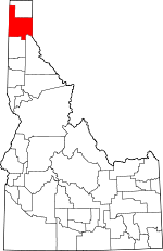
Bonner County, Idaho Basics:


Bonner County Idaho - Government Site

Population: 40,456
Area: 1735 square miles
County seat: Sandpoint
Area code(s) in use: 208
Time zone: PST
High school graduate or higher: 90.5%
Bachelor's degree or higher: 21.5%
Median household income: $41,379
Persons in poverty: 16.3%
Home ownership rate: 72.5%
Mean travel time to work: 23.7 minutes


Adjacent counties:
Boundary  Kootenai  Lincoln (MT)  Pend Oreille (WA)  Sanders (MT)  Shoshone  Spokane (WA)  
Find in Idaho

Map of the Bonner County area


Our detail map of Bonner County shows the Bonner County, Idaho boundary lines and other interesting items.

Places in Bonner County, Idaho

  Airports     show all on map

Athol Airport, Bird Number Two Airport, Bottle Bay Seaplane Base, Cavanaugh Bay Airport, CX Ranch Airport, Flying W Ranch Airport, Granite Airport, Henley Airstrip, Lake Pend Oreille Seaplane Base, Murray Airport, Olmstead Sky Ranch, Priest Lake-US Forest Service Airport, Priest River Municipal Airport, Sandpoint Airport, Timber Basin Ranch Airport, Treeport Airport, Valenov Ranch Airport

  Areas     show all on map

Garten Meadow, Matchwood

  Basins     show all on map

Auxor Basin, Otts Basin, Schweitzer Basin

  Bays     show all on map

Albeni Cove, Bear Creek Bay, Bottle Bay, Bottle Bay, Camp Bay, Cavanaugh Bay, Distillery Bay, Elliot Bay, Ellisport Bay, Garfield Bay, Green Bay, Huckleberry Bay, Indian Creek Bay, Kalispell Bay, Kilroy Bay, Kootenai Bay, Luby Bay, Mallard Bay, Martin Bay, Mosquito Bay, Murphy Bay, Oden Bay, Outlet Bay, Owens Bay, Pine Cove, Reeder Bay, Shoshone Bay, Squaw Bay, Steamboat Bay, Sunrise Bay, Teachers Bay, Tule Bay, Whiskey Rock Bay

  Buildings     show all on map

Blanchard Fire Station 2, Bonner County Emergency Medical Services, Bonner County Emergency Medical Services, Bonner County Emergency Medical Services, Bonner County Sheriff's Office, Clark Fork Ambulance Service, Clark Fork Valley Fire Department, Coolin Cavanaugh Bay Fire District, Edgemere Grange, Grange Hall, Hope - East Hope Volunteer Fire Department, Idaho Department of Lands Priest Lake Fire Protection District Station, Memorial Park Historical Museum, North of the Narrows Fire District, Northside Fire District Station 1, Northside Fire District Station 2, Northside Fire District Station 3, Northside Fire District Station 4, Ponderay Police Department, Priest Lake Ambulance Service, Priest River Police Department, Sagle Fire District Station 1, Sagle Fire District Station 2, Sagle Fire District Station 3, Sagle Fire District Station 4, Sagle Fire District Station 5, Sam Owen Fire District, Sandpoint Fire Department, Schweitzer Fire District, Snow Valley Grange, Spirit Lake Fire Station 3, Timberlake Fire Protection District Station 6, West Pend Oreille Fire District, West Priest Lake Fire Department Station 1, West Priest Lake Fire Department Station 2, Westside Fire Protection District Station 1, Westside Fire Protection District Station 2

  Capes     show all on map

Anderson Point, Bottle Bay Point, Canoe Point, Cape Horn, Cape Horn, Contest Point, Deadman Point, Graham Point, Granite Point, Grouse Mountain Point, Hawkins Point, Hess Point, Hope Point, Indian Point, Indian Rock, Kootenai Point, Long Point, Maiden Rock, Mineral Point, Picard Point, Pinto Point, Plumbago Point, Ponder Point, Rocky Point, Rocky Point, Sheepherder Point, Sourdough Point, Springy Point, Tripod Point, Windy Point

  Cemeteries     show all on map

Clara Cemetery, Drake Cemetery, Gold Creek Cemetery, Hope Cemetery, Lakeview Cemetery, Pack River Cemetery, Pine Grove Cemetery, Pinecrest Cemetery, Seneacquoteen Cemetery, Westmond Cemetery

  Census     show all on map

Blanchard Census Designated Place

  Channels     show all on map

Priest Lake Incubation Channels, The Thorofare

  Cliffs     show all on map

Echo Rock, Uleda Point

  Dams     show all on map

Albeni Falls Dam, Albeni Falls Dam, Blanchard Creek Dam, Cabinet Gorge Dam, Cocolalla Creek Fish Weir, Outlet Dam, Priest Lake Dam, Stoneridge Dam

  Falls     show all on map

Albeni Falls, Char Falls, Grouse Creek Falls, McAbee Falls, Mission Falls, Torrelle Falls

  Flats     show all on map

Armstrong Meadows, Big Meadows, Bismark Meadows, Boulder Meadows, Daggett Meadow, Gleason Meadow, Hanna Flats, Jack Pine Flats, McCormack Meadows, Mountain Meadow, Pack River Flats, Packer Meadows, Snow Valley, The Old Maids Clearing, The Settlement

  Forests     show all on map

Priest River Experimental Forest

  Gaps     show all on map

Beaver Pass, Buckskin Saddle, Canyon Gap, Happy Fork Gap, Johnson Saddle, Weber Saddle

  Guts     show all on map

Denton Slough

  Hospitals     show all on map

Bonner General Hospital

  Islands     show all on map

Bartoo Island, Cottage Island, Derr Island, Eightmile Island, Fisherman Island, Fourmile Island, Kalispell Island, Kelly Island, Memaloose Island, Papoose Island, Pearl Island, Rat Island, Strong Island, Twin Islands, Warren Island

  Lakes     show all on map

Antelope Lake, Beaver Lake, Beaver Lake, Blacktail Lake, Blanchard Lake, Blue Lake, Bottle Lake, Caribou Lake, Chase Lake, Cocolalla Lake, Dennick Lake, Eaton Lake, Freeman Lake, Gamlin Lake, Gem Lake, Granite Lake, Hager Lake, Heath Lake, Hoodoo Lake, Jewel Lake, Kelso Lake, Keokee Lake, Kerr Lake, Kilroy Lakes, Lake Darling, Lake Estelle, Lake Pend Oreille, Lambertson Lake, Lee Lake, Little Lake, Little Muskrat Lake, Livermore Lake, Lost Lake, Lost Lake, Mirror Lake, Moose Lake, Mud Lake, Muskrat Lake, Porcupine Lake, Providence Lake, Round Lake, Round Lake, Sand Lake, Schlicht Lake, Shepherd Lake, Smith Lake, Still Lake, Upper Priest Lake, Walsh Lake

  Locales     show all on map

Albeni Cove Campground, Albeni Falls Campground, Albeni Falls Dam Picnic Area, Baritoe Campground, Beaver Cabin (historical), Beaver Creek Recreation Site, Beaver Lake Ranch, Benning Lookout (historical), Bernard Overlook, Bismark Work Center, Bonner County Fairgrounds, Bonner Mall, Bronx Substation, Cabinet Dam Viewpoint, Cabinet Gorge Hatchery, Camp Codge, Camp Stidwell, Canoe Camp, Carey Boat Ramp, Caribou Lookout, Cavanaugh Bay Headquarters, Center Valley School (historical), Chase Lake Access Area, Clark Fork Fish Hatchery, Clark Fork Fish Hatchery, Clark Fork Ranger Station (historical), Cocolalla Lake Access Area, Cocolalla Siding, Colburn Day Lodge, Colby, CX Ranch, David Thompson Historical Monument, Delyle Campground (historical), Dickensheet Campground, Dry Gulch Cabin (historical), East Fork Public Campground (historical), East Kootenai, Evans Landing Picnic Area, Falls Ranger Station, Forest Siding, Freeman Lake Access Area, Garfield Bay Access Area, Garfield Bay Recreation Site, Gisbourne Mountain Vista, Gramite Lake Access Area, Granite Creek Campground, Granite Lake Access, Gravel Pit, Green Bay Recreation Site, Grouse Creek School (historical), Hoodoo Rest Area, Huckleberry Mountain Lookout, Idaho State Fish Hatchery, Indian Creek Campground, Jewel Lake Access Area, Johnson Point Vista, Kalispell Point Boat Ramp, Kelso Lake Access, Kelso Lake Access Area, Laclede Boat Ramp, Lake Plaza, Lakeview Sanitary Landfill, Ledgewood Picnic Area, Lionhead Recretaion Site, Luby Bay Campground, Maiden Rock Picnic Area, Midas (historical), Mirror Lake Access, Mirror Lake Access Area, Morton Slough Access, Navigation Campground, Newport Hill Lookout, Nordman Campground, North Cove Campground, Oden School (historical), Osprey Campground, Osprey Nests Viewpoint, Outlet Campground, Pack River Boat Ramp, Pine Street Ski Area, Plowboy Campground, Porcupine Lake Campground, Priest Lake Golf Club, Priest Lake Marina, Priest Lake Ranger Station, Priest Lake State Park Indian Creek Unit, Priest Lake State Park Lionhead Unit, Priest River Campground, Priest River Experimental Station, Pringle Boat Launch, Rattle Creek Cabin (historical), Reeder Bay Campground, Rocky Point Campground, Round Lake Campground, Sagle Community Hall, Samowen Campground, Sandpoint Fish Hatchery, Sandpoint Mall, Sandpoint Substation, Schneider Campground, Schweitzer Basin Ski Area, Shepherd Lake Access Area, Silver Campground, Smith Cabin, Smith Patrol Lookout, Spirit Pines Church Camp, Springy Point Campground, Spruce, Stone Johnny Lookout, Strong Island Picnic Area, Summit Camp, Sundance Lookout Station, Sunnyside Park Access Area, Three Pines Campground, Timberline Center, Trestle Creek Boat Ramp, Trestle Creek Recreation Site, Tumbledown Guard Station, Two Mouth Guard Station, Upper Priest Lake Scenic Area, Vinther-Nelson Historical Cabin, Whiskey Rock Recreation Site, Woodside

  Mines     show all on map

Auxor Mine, Bellville Mine, Bodie Canyon Mine, Carey Pits, Carpie Mine, Conjecture Mine, Dixie Queen Mine, Dougherty Mine, Falls Creek Mine, Gold Coin Mine, Green Monarch Mine, Grey Brothers Lime Quarry, Hope and Faith Shaft, Hope Mine, Idaho Lakeview Mine, Keep Cool Mine, Lakeview Mines, Lawrence Mine, Minerva Mine, Mountain Chief Mine, Navigation Mine, New Rainbow Mine, Plowboy Mine, Portland Group Mine, Schafer Mine, Silver Leaf Mine, Sulphide Mine, Talache Mine, Vulcan Mine, Weber Mine, Whitedelf Mine, Woodrat Mine

  Parks     show all on map

Bottle Lake Research Natural Area, Canyon Creek Recreational Natural Area, Carey Creek Game Management Area, David Thompson State Wildlife Preserve, Kaniksu Marsh Research Natural Area, Morton Slough Game Management Area, North Shore Game Management Area, Oden Bay Game Management Area, Pack River Flats Refuge, Panhandle Wildlife Management Area, Pend Oreille Wildlife Management Area, Pine Street Park, Priest River Park, Riley Creek Recreation Area, Round Lake State Park, Samowen Park, Tepee Creek Research Natural Area, Triangle Park

  Pillars     show all on map

Whiskey Rock

  Populated Places     show all on map

Algoma, Blacktail, Blanchard, Boyer, Bronx, Broten, Cabinet, Careywood, Cedar Creek, Clagstone, Clark Fork, Cocolalla, Colburn, Coleman, Coolin, Culver, Denton, Dickensheet Junction, Dover, Dufort, East Hope, Edgemere, Elmira, Evans Landing, Four Corners, Garfield, Glengary, Granite, Granite, Harlem, Hope, Kelso, Kootenai, Laclede, Lakeview, Lamb Creek, Lignite, Morton, Newman, Nordman, Oden, Oldtown, Outlet Bay, Ponderay, Priest River, Riverside (historical), Sagle, Samuels, Sandpoint, Sawyer, Selle, Seneacquoteen, Sherwood Beach, Sunnyside, Talache, Talache Landing, Thama, Trestle Creek, Vans Corner, Vay, Westmond, Wrencoe

  Post Offices     show all on map

Broten Post Office (historical), Riverside Post Office (historical)

  Rapidss     show all on map

Chipmunk Rapids

  Reserves     show all on map

Hoodoo Game Management Area, Pend Oreille Wildlife Management Area Carey Unit, Pend Oreille Wildlife Management Area Mallard Bay Unit, Pend Oreille Wildlife Management Area Morton Slough Unit, Pend Oreille Wildlife Management Area Oden Bay Unit, Pend Oreille Wildlife Management Area Pack River Unit, Priest River Game Management Area, Riley Creek Game Management Area

  Reservoirs     show all on map

Cabinet Gorge Reservoir, Lake San Souci, Priest Lake, Reeder Lake

  Ridges     show all on map

Bimetallic Ridge, Delyle Ridge, Elk Ridge, Gold Ridge, Green Monarch Ridge, Hellroaring Ridge, Minerva Ridge, Peep a Day Ridge, Pelke Divide, Sand Ridge, Sherman Ridge, Toms Ridge, Trestle Ridge, White Quartz Ridge

  Schools     show all on map

Athol Elementary School, Clark Fork Junior-Senior High School, Eagle Mountain Outpost, Edgemere School, Farmin School (historical), Farmin/Stidwell Elementary School, Gold Creek School (historical), Hope Elementary School, House of the Lord Christian Academy, Idaho Hill Elementary School, Idaho School, Lake Pend Oreille High School, Lincoln School (historical), Newman School, Northside Elementary School, Pend Oreille Valley Seventh-Day Adventist School, Priest Lake Elementary School, Priest River Elementary School, Priest River High School, Priest River High School (historical), Priest River Junior High School, Sagle Elementary School, Sandpoint High School, Sandpoint Junior Academy, Sandpoint Middle School, Selkirk School, Snow Valley Academy, Southside Elementary School, University of Idaho Clark Fork Field Campus, Washington Elementary School

  Springs     show all on map

Benton Spring, Rock Spring, Sheef Spring, Sheep Springs, Sullivan Spring

  Streams     show all on map

Albeni Falls Creek, Alder Creek, Alpine Creek, Angel Creek, Athol Creek, Bath Creek, Bayview Creek, Bear Creek, Bear Paw Creek, Beaver Creek, Beaver Creek, Benton Creek, Berry Creek, Big Creek, Big H Creek, Binarch Creek, Blacktail Creek, Blanchard Creek, Blonc Creek, Bloom Creek, Blue Creek, Bodenstein Creek, Bottle Creek, Boulder Creek, Boyer Slough, Branch North Gold Creek, BRC Creek, Bridgeview Creek, Brier Creek, Brush Creek, Bug Creek, Bugle Creek, Butler Creek, Button Creek, Camp Creek, Camp Creek, Candle Creek, Canyon Creek, Canyon Creek, Cape Horn Creek, Careywood Creek, Caribou Creek, Caribou Creek, Caribou Creek, Carr Creek, Carter Creek, Cascade Creek, Cedar Creek, Cedar Creek, Char Creek, Chase Creek, Cheer Creek, Chess Creek, Chicopee Creek, Chuck Slough, Chute Creek, Clark Fork, Clatter Creek, Cliff Creek, Cochran Creek, Cocolalla Creek, Colburn Creek, Consalus Creek, Cottonwood Creek, Cougar Creek, Cougar Creek, Crazy Creek, Cuban Creek, Curtis Creek, Dead Man Creek, Deadman Creek, Declaration Creek, Deer Creek, Delyle Creek, Derr Creek, Devils Creek, Done Creek, Dry Creek, Dubius Creek, Dusty Creek, Dyree Creek, East Fork Creek, East Fork Moores Creek, East Fork Trapper Creek, East River, Ellis Creek, Emerson Creek, Ermine Creek, Fall Creek, Falls Creek, Fedar Creek, Fenton Creek, Fish Creek, Fish Creek, Flat Creek, Floss Creek, Flume Creek, Flume Creek, Fox Creek, Freeman Creek, French Creek, Frezkat Creek, Fry Creek, Garfield Creek, Garten Creek, Gem Creek, Glad Creek, Glazier Creek, Gold Creek, Gold Creek, Gold Creek, Gold Creek, Goose Creek, Goose Creek, Gordon Creek, Granite Creek, Granite Creek, Gray Creek, Grouse Creek, Guinn Creek, Halfway Creek, Halverson Creek, Happy Fork, Hathaway Creek, Hazard Creek, Hellroaring Creek, Hickman Creek, Hoodoo Creek, Hornby Creek, Horton Creek, Hughes Fork, Hunt Creek, Indian Creek, Indian Creek, Jack Creek, Johnson Creek, Johnson Creek, Johnson Creek, Jones Creek, Jost Creek, Jost Creek, Jungle Creek, Junta Creek, Kalispell Creek, Kavanaugh Creek, Keokee Creek, Kilroy Creek, Kirby Creek, Koch Creek, Kreiger Creek, Lamb Creek, Ledge Creek, Lee Creek, Lightning Creek, Lindsey Creek, Lion Creek, Little Pine Creek, Little Sand Creek, Lost Creek, Lost Creek, Lower West Branch Priest River, Lucky Creek, Lunch Creek, Maiden Creek, Manley Creek, McDonald Creek, Media Creek, Micro Creek, Middle Fork Clark Fork, Middle Fork East River, Mill Creek, Mink Creek, Mirror Creek, Moore Creek, Moores Creek, Moose Creek, Morris Creek, Morton Slough, Mosquito Creek, Mosquito Creek, Mud Creek, Murphy Slough, Murray Creek, Muskegon Creek, North Fork Big Creek, North Fork Clark Fork, North Fork Creek, North Fork Delyle Creek, North Fork East River, North Fork Granite Creek, North Fork Grouse Creek, North Fork Indian Creek, North Fork Squaw Creek, North Fork Twin Creek, North Gold Creek, North Twin Creek, Nosebag Creek, Nuisance Creek, Old Maid Creek, Ole Creek, Pack River, Packer Creek, Packsaddle Creek, Pearl Creek, Peewee Creek, Pine Creek, Plank Creek, Poirier Creek, Pole Creek, Porcupine Creek, Prater Creek, Priest River, Prospect Creek, Puzzle Creek, Quartz Creek, Quartz Creek, Race Creek, Ranger Creek, Rapid Lightning Creek, Rattle Creek, Raymond Creek, Reeder Creek, Regal Creek, Reynolds Creek, Riley Creek, Riser Creek, Roger Creek, Ruby Creek, Ruen Creek, Saddler Creek, Sagle Slough, Salee Creek, Sanborn Creek, Sand Creek, Sand Creek, Savage Creek, Schweitzer Creek, Sheep Creek, Shertz Creek, Silvertip Creek, Skip Creek, Slough Creek, Smith Creek, Smith Creek, Smorgasbord Creek, Snow Creek, Snowshoe Creek, Soldier Creek, South Fork Clark Fork, South Fork Gold Creek, South Fork Granite Creek, South Fork Grouse Creek, South Fork Hunt Creek, South Fork Indian Creek, South Fork Lion Creek, South Fork Porcupine Creek, South Fork Wellington Creek, South Ole Creek, South Twin Creek, Spirit Creek, Spring Creek, Spring Creek, Spring Creek, Squaw Creek, State Creek, Steep Creek, Steep Creek, Strawberry Creek, Strong Creek, Strong Creek, Summit Creek, Surprise Creek, Sweasey Creek, Swede Creek, Syringa Creek, Taffy Creek, Talache Creek, Tango Creek, Tarlac Creek, Tavern Creek, Tepee Creek, Three Sisters Creek, Tola Creek, Trapper Creek, Trapper Creek, Trapper Creek, Trespass Creek, Trestle Creek, Trickle Creek, Trout Creek, Tumbledown Creek, Tunnel Creek, Turnipseed Creek, Twin Creek, Two Mouth Creek, Uleda Creek, Upper Priest River, Upper West Branch Priest River, Waters Creek, Wellington Creek, West Fork Blue Creek, West Fork Keeler Creek, West Fork Moores Creek, West Fork Packer Creek, West Gold Creek, West Johnson Creek, Westmond Creek, White Creek, Willard Creek, Wylie Creek, Zero Creek

  Summits     show all on map

Antelope Mountain, Atlasta Mountain, Bald Mountain, Barton Hump, Bear Mountain, Bee Top Mountain, Benning Mountain, Binarch Mountain, Bismark Mountain, Black Pine Mountain, Blacktail Mountain, Blacktail Mountain, Blacktop Mountain, Blue Mountain, Boulder Mountain, Butler Mountain, Calder Mountain, Cape Horn Peak, Caribou Hill, Coolin Mountain, Cottonwood Point, Cougar Peak, Cuban Hill, Derr Point, Dusty Peak, East Fork Peak, Elmira Peak, Faset Peak, Flattop, Fleming Point, Gisborne Mountain, Goat Mountain, Gold Cup Mountain, Gold Hill, Gold Mountain, Gold Peak, Granite Mountain, Green Monarch Mountain, Green Mountain, Grief Mountain, Grouse Mountain, Grouse Mountain, Grouse Mountain, Honey Mountain, Hoodoo Mountain, Horn Mountain, Howe Mountain, Huckleberry Mountain, Jakes Mountain, Jasper Mountain, Johnny Long Mountain, Johnson Peak, Keokee Mountain, Kirby Mountain, Lafoe Mountain, Lakeview Mountain, Lightning Mountain, Lightning Peak, Lindsey Mountain, Little Blacktail Mountain, Little Grass Mountain, Long Mountain, Long Mountain, Lost Peak, Lunch Peak, Minerva Peak, Moose Mountain, Mount Casey, Mount Eagen, Mount Marion, Mount Pend Oreille, Mount Willard, Newport Hill, Nickelplate Mountain, Outlet Mountain, Packsaddle Mountain, Pewee Peak, Pitz Mountain, Plowboy Mountain, Powder Mountain, Prater Mountain, Prospect Peak, Purdy Mountain, Quartz Mountain, Rattle Mountain, Reed Hill, Reeder Mountain, Roberts Mountain, Roothaan Mountain, Round Top Mountain, Schafer Peak, Scotchman Number Two, Scotchman Peak, Smith Mountain, Spruce Mountain, Stone Johnny, Strawberry Mountain, Sugarloaf Mountain, Sundance Mountain, Sunnyside Mountain, Tank Hill, Three Sisters Peaks, Tola Point, Trestle Peak, Trout Peak, Twin Peaks, Watson Mountain, Whitetail Butte, Wylie Knob

  Swamps     show all on map

Colburn Lake

  Towers     show all on map

Indian Mountain Lookout Tower, KJDE-FM (Sandpoint), KPND-FM (Sandpoint), KSPT-AM (Sandpoint)

  Trails     show all on map

Alpine Trail, Chipmunk Rapids National Recreation Trail, Dixie Queen Trail, Green Mountain Trail, Hanna Flats Nature Trail, Hemlock Trail, North Fork Trail, Shertz Trail, Upper Declaration Trail

  Valleys     show all on map

Bath Creek Gorge, Becker Draw, Blanchard Valley, Bodie Canyon, Cabinet Gorge, Chloride Gulch, Cochran Draw, Deer Gulch, Dry Gulch, Elk Gulch, Gold Gulch, Hays Gulch, Jinks Gulch, Kick Bush Gulch, Langell Canyon, McQuade Gulch, Melder Draw, Old Doe Draw, Schafer Gulch, Spirit Valley, Strong Draw, Tepee Gulch, Togo Gulch, Toms Gulch, Webb Canyon,

Bonner County, Idaho Population By Race (2012 estimate)

RacePopulation
WhiteBonner County White population 38,91938,918  
MixedBonner County Mixed population 850849
American IndianBonner County American Indian population 364364
AsianBonner County Asian population 243242
BlackBonner County Black population 8180
Hawaiian & Pacific IslanderBonner County Hawaiian & Pacific Islander population 4040

Additional population tables :
State population table
Idaho population by county