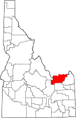
Clark County, Idaho Basics:


Clark County Idaho - Government Site

Population: 874
Area: 1764 square miles
County seat: Dubois
Area code(s) in use: 208
Time zone: MST
High school graduate or higher: 66.1%
Bachelor's degree or higher: 12.7%
Median household income: $35,833
Persons in poverty: 14.2%
Home ownership rate: 66.6%
Mean travel time to work: 16.9 minutes


Adjacent counties:
Beaverhead (MT)  Butte  Fremont  Jefferson  Lemhi  
Find in Idaho

Map of the Clark County area


Our detail map of Clark County shows the Clark County, Idaho boundary lines and other interesting items.

Places in Clark County, Idaho

  Airports     show all on map

Dubois Municipal Airport

  Basins     show all on map

Argora, Slate Basin

  Buildings     show all on map

Clark County Ambulance, Dubois City Fire Department, Dubois County Sheriff's Office

  Canals     show all on map

Reno Ditch

  Cemeteries     show all on map

Goddard Cemetery, John Day Cemetery, Kilgore Cemetery, New Kilgore Cemetery

  Cliffs     show all on map

China Point, Reno Point

  Craters     show all on map

Morgan Crater, The Crater

  Dams     show all on map

Park Dam, Paul Dam, Sheridan Dam

  Flats     show all on map

Camas Meadows, Dutch Flat, Hirschi Flat, Mule Meadows, Waters Flat

  Gaps     show all on map

Bannack Pass, Devils Gap, Lone Pine Pass, Monida Pass, Porcupine Pass

  Lakes     show all on map

Aldous Lake, Antelope Lakes, Divide Creek Lake, Hancock Lake, Little Lake, Walking Fish Lake

  Locales     show all on map

Beaver Creek Campground, Birch Creek Hatchery, Cow Camp, East Camos Campground, Edie Ranch, Jacoby Ranch, Kaufman Guard Station, Reno Ranch, Small, Steel Creek Campground, Stoddard Creek Campground, United States Experiment Station

  Mines     show all on map

Coal Mine

  Parks     show all on map

Indian Massacre Historical Monument

  Pillars     show all on map

Split Rock

  Populated Places     show all on map

Blue Dome, Dubois, Eighteenmile, Highbridge, Humphrey, Idmon, Jones Crossing, Kaufman (historical), Kilgore, Lidy Hot Springs, Lone Pine, Old Beaver, Spencer, Winsper

  Ranges     show all on map

Centennial Mountains, Eastern Centennial Mountains, Western Centennial Mountains

  Reserves     show all on map

United States Sheep Experiment Station

  Reservoirs     show all on map

Gardner Lake, Paul Reservoir, Sheridan Reservoir, Threemile Reservoir

  Ridges     show all on map

Antelope Ridge, Chicken Ridge, Horse Ridge, Pete Creek Divide, Sheridan Ridge

  Schools     show all on map

Clark County Junior-Senior High School, Lindy Ross Elementary School

  Springs     show all on map

Antelope Spring, Bald Mountain Spring, Big Spring, Blue Canyon Spring, Blue Creek Spring, Boatman Spring, Boulder Spring, Chandler Spring, Cow Camp Spring, Edie Spring, Frog Spring (historical), Hoolie Springs, Keg Spring, Kitty Spring, Lidy Hot Springs, Lone Pine Spring, Lower Crystal Spring, Miners Creek Spring, Owens Spring, Palmer Springs, Pass Creek Spring, Rock Spring, Shamrock Spring, Stinking Spring, Sweat Springs, Three Springs, Upper Crystal Spring, Warm Springs

  Streams     show all on map

Bear Pen Creek, Bear Trap Creek, Berry Creek, Big Spring Creek, Blue Creek, Cabin Creek, Calf Creek, Camp Creek, Castle Creek, Chicken Creek, Ching Creek, Clay Creek, Cobble Creek, Cold Creek, Coon Creek, Corral Creek, Corral Creek, Cottonwood Creek, Cottonwood Creek, Cow Creek, Crab Creek, Crooked Creek, Crooked Creek, Dairy Creek, Dead Horse Creek, Deep Creek, Disaster Creek, Ditch Creek, Divide Creek, Dry Creek, Dry Creek, Dry Creek, East Camas Creek, East Dry Creek, East Dry Creek, East Dry Creek, East Fork Cottonwood Creek, East Fork Dry Creek, East Fork Indian Creek, East Fork Rattlesnake Creek, East Fork Sheridan Creek, East Modoc Creek, East Steel Creek, East Threemile Creek, Edie Creek, Flat Creek, Frazier Creek, Fritz Creek, Fryingpan Creek, Grouse Creek, Headquarters Creek, Horse Creek, Horse Creek, Howard Creek, Idaho Creek, Indian Creek, Irving Creek, Jug Creek, Kay Creek, Keg Spring Creek, Kettle Creek, Kick Creek, Lake Creek, Lake Creek, Larkspur Creek, Lava Creek, Left Fork Creek, Left Fork Middle Creek, Little Ching Creek, Little Creek, Little Lake Creek, Little Warm Creek, Long Creek, Lymans Creek, McNeary Creek, Meadow Creek, Medicine Lodge Creek, Middle Creek, Middle Dry Creek, Middle Fork Sheridan Creek, Middle Modoc Creek, Middle Threemile Creek, Mill Creek, Miners Creek, Modoc Creek, Moose Creek, Mud Creek, Mule Meadows Creek, Myers Creek, North Fork Fritz Creek, Owens Creek, Pass Creek, Pass Creek, Pasture Creek, Patelzick Creek, Pete Creek, Pleasant Valley Creek, Poison Creek, Ramshorn Creek, Rattlesnake Creek, Robbins Creek, Rock Creek, Rocky Creek, Salamander Creek, Salt Creek, Saw Creek, Scalp Creek, Schneider Creek, School Section Creek, Sheep Creek, South Fork Deep Creek, South Fork Fritz Creek, South Fork Webber Creek, Spring Creek, Spring Creek, Spruce Creek, Steel Creek, Stoddard Creek, Stump Creek, Taylor Creek, Telephone Creek, The Bull Pen, Threemile Creek, Trail Creek, Twin Creek, Warm Creek, Warm Creek, Warm Springs Creek, Webber Creek, West Camas Creek, West Dry Creek, West Dry Creek, West Fork Cottonwood Creek, West Fork Indian Creek, West Fork Rattlesnake Creek, West Fork Sheridan Creek, West Modoc Creek, West Steel Creek, West Threemile Creek, Willow Creek, Willow Creek

  Summits     show all on map

Bald Mountain, Baldy Mountain, Beacon Hill, Bed Springs Butte, Big Table Mountain, Black Mountain, Bluebird Mountain, Button Butte, Castle Peak, Cedar Butte, Cinder Butte, Copper Mountain, Fritz Peak, Gallagher Peak, Heart Mountain, Horse Mountain, Indian Creek Butte, Knob Mountain, Knoll, Lone Butte, Lookout Point, Mahogany Butte, Maud Mountain, Middle Creek Butte, Opal Mountain, Rattlesnake Point, Red Conglomerate Peaks, Scott Butte, Signal Peak, Slide Mountain, Snowshoe Butte, Taylor Mountain, The Thumb, Tyler Peak

  Trails     show all on map

Bear Hole Trail, East Sheridan Creek Trail, Headquarters Trail, Howard Creek Trail, Huntley Canyon Trail, Middle Fork Trail, Sheridan Creek Trail, Stoddard Creek Trail, Table Mountain Trail, Taylor Creek Trail

  Valleys     show all on map

Alex Draw, Allan Canyon, Anderson Gulch, Antelope Valley, Aspen Draw, Bald Mountain Gulch, Bare Canyon, Bear Canyon, Bear Cat Canyon, Bear Gulch, Bear Wallow Canyon, Big Dry Canyon, Birch Creek Valley, Black Canyon, Black Horse Canyon, Bloom Canyon, Blue Canyon, Broad Hollow, Brooks Canyon, Bruce Canyon, Buckboard Gulch, Buckhorn Canyon, Burnt Canyon, Burnt Canyon, Campbell Gulch, Carrot Canyon, Chandler Canyon, Cole Canyon, Corral Canyon, Crystal Gulch, Deadman Canyon, Deer Canyon, East Fork Bear Gulch, Eightmile Canyon, Fulwider Gulch, Gallagher Canyon, Goddard Canyon, Grouse Canyon, Heart Canyon, Huntley Canyon, Idaho Hollow, Juniper Gulch, Kaufman Gulch, Kelly Canyon, Kite Canyon, Lake Hollow, Limestone Gulch, Little Sawmill Canyon, Long Canyon, McGarry Canyon, Middle Fork Eightmile Canyon, Nicholia Canyon, North Fork Eightmile Canyon, O'Brien Gulch, Peterson Canyon, Picnic Hollow, Pierce Canyon, Pleasant Valley, Poison Gulch, Post Canyon, Post Hollow, Red Canyon, Reno Gulch, Robertson Gulch, Rocky Canyon, Sawmill Canyon, Shamrock Gulch, Shamrock Gulch, Skull Canyon, Snaky Canyon, South Fork Eightmile Canyon, Spring Canyon, Spring Hollow, Surrett Canyon, Swampy Draw, Tenpin Gulch, Tepee Draw, Thomas Draw, Thunder Gulch, Timber Canyon, Tyler Canyon, Van Noy Canyon, White Pine Canyon, Windfall Canyon, Wood Canyon, Worthing Canyon

  Wells     show all on map

Camas Butte Well, Cedar Butte Well, Dutch Flat Well,

Clark County, Idaho Population By Race (2012 estimate)

RacePopulation
WhiteClark County White population 820819  
American IndianClark County American Indian population 1919
MixedClark County Mixed population 1818
AsianClark County Asian population 98
BlackClark County Black population 87
Hawaiian & Pacific IslanderClark County Hawaiian & Pacific Islander population 00

Additional population tables :
State population table
Idaho population by county