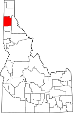
Kootenai County, Idaho Basics:


Kootenai County Idaho - Government Site

Population: 142,278
Area: 1244 square miles
County seat: Coeur d Alene
Area code(s) in use: 208
Time zone: PST
High school graduate or higher: 92.2%
Bachelor's degree or higher: 23.8%
Median household income: $49,151
Persons in poverty: 12.8%
Home ownership rate: 70.2%
Mean travel time to work: 20.9 minutes


Adjacent counties:
Benewah  Bonner  Shoshone  Spokane (WA)  
Find in Idaho

Map of the Kootenai County area


Our detail map of Kootenai County shows the Kootenai County, Idaho boundary lines and other interesting items.

Places in Kootenai County, Idaho

  Airports     show all on map

Brooks Seaplane Base, Cedar Mountain Sky Ranch, Coeur D'Alene Air Terminal, Coeur D'Alene Resort Heliport, Hackney Airpark, Hawk Haven Airport, Hickman Airport, Hooks Airport, Hubofs Heliport, Kootenai Medical Center Heliport, Nichols Ranch Airport, Otterson Ranch Airport, Ranch Aero Airport, Round Mountain Aerodrome, Silverwood Airport, Smith Ranch Airport

  Basins     show all on map

Hidden Valley

  Bays     show all on map

16 to 1 Bay, Aberdeen Lodge Bay, Beauty Bay, Bell Bay, Bennett Bay, Berven Bay, Black Bay, Black Bay, Black Rock Bay, Bloomsburg Bay, Blue Creek Bay, Bozanta Tavern Bay, Browns Bay, Carey Bay, Carlin Bay, Casco Bay, Cave Bay, Cleland Bay, Coopers Bay, Cottonwood Bay, Cougar Bay, Cramps Bay, Crescent Bay, Driftwood Bay, Echo Bay, Echo Bay, Everwell Bay, Fullers Bay, Gand Bay, Gotham Bay, Half Round Bay, Happy Cove, Honeysuckle Bay, Idlewilde Bay, Kid Island Bay, Little Cottonwood Bay, Loffs Bay, Lowmeister Bay, Martin Bay, McLeans Bay, Mica Bay, Mokins Bay, Moscow Bay, Neachen Bay, O'Gara Bay, O'Rourke Bay, Powderhorn Bay, Rockford Bay, Scenic Bay, Shingle Bay, Sixteen-to-One Bay, Skinner Bay, Sun Up Bay, Swede Bay, Turner Bay, Windy Bay, Windy Bay, Wolf Lodge Bay

  Beaches     show all on map

Honeysuckle Beach, Preston Beach, Sanders Beach, Silver Beach

  Bends     show all on map

Schetkwe' (historical)

  Buildings     show all on map

Bureau of Land Management Coeur d'Alene District, Bureau of Land Management Coeur d'Alene Field Office, Coeur D'Alene Fire Department Station 1, Coeur D'Alene Fire Department Station 2, Coeur D'Alene Fire Department Station 3, Coeur d'Alene Police Department, East Side Fire District 1, East Side Fire District 2, East Side Fire District 3, Hauser Lake Fire Department, Kootenai County Fire and Rescue Station 1, Kootenai County Fire and Rescue Station 2, Kootenai County Fire and Rescue Station 3, Kootenai County Fire and Rescue Station 4, Kootenai County Fire and Rescue Station 5, Kootenai County Fire and Rescue Station 6, Kootenai County Fire and Rescue Station 7, Kootenai County Sheriff's Office, Mica - Kidd Island Fire Department, Northern Lakes Fire Protection District Station 1, Northern Lakes Fire Protection District Station 2, Northern Lakes Fire Protection District Station 3, Northern Lakes Fire Protection District Station 4, Northern Lakes Fire Protection District Station 5, Northern Lakes Fire Protection District Station 6, Northern Lakes Fire Protection District Station 7, Post Falls City Police, Rathdrum Police Department, Saint Maries Fire Protection District Station 2, Saint Maries Fire Protection District Station 3, Shoshone County Fire Protection District 2 Doyle Road Station, Spirit Lake Fire District Station 1, Spirit Lake Police Department, Timberlake Fire Protection District Station 1, Timberlake Fire Protection District Station 2, Timberlake Fire Protection District Station 3, Timberlake Fire Protection District Station 4, Timberlake Fire Protection District Station 5, Worley Fire District Station 1, Worley Fire District Station 2, Worley Fire District Station 3, Worley Fire District Station 4, Worley Fire District Station 4, Worley Fire District Station 5, Worley Fire District Station 6, Worley Fire District Station 7

  Canals     show all on map

East Greenacres East Ditch, East Greenacres Main Ditch, East Greenacres North Ditch, Hy Line Ditch, Mikelson Canal

  Capes     show all on map

Arrow Point, Beedle Point, Black Rock, Blackwell Point, Browns Point, Cellar Point, Chicken Point, Chippy Point, Clark Point, Conkling Point, Delcardo Bay, Donavons Point, Driftwood Point, East Point, English Point, Evernade Point, Gasser Point, Harlow Point, Harts Island, Independence Point, Lees Point, Lyndale Landing, McDonald Point, North Cape, Pilot Rock Sandpoint, Pugh Point, Reynolds Point, Rockford Point, Spokane Point, Steamboat Rock, Stevens Point, Swede Point, Threemile Point, University Point, Valhalla Point, Windy Point, Yellowstone Point

  Cemeteries     show all on map

Bestland Cemetery, Coeur d'Alene Indian Cemetery, Evergreen Cemetery, Forest Cemetery, Greenwood Cemetery, Lane Cemetery, Medimont Cemetery, Mountain View Cemetery, Old Mission Cemetery, Pine Grove Cemetery, Restlawn Memorial Park, Rimrock Cemetery, Rose Lake Cemetery, Saint Thomas Cemetery, Worley Cemetery

  Census     show all on map

Conkling Park Census Designated Place, Rockford Bay Census Designated Place

  Channels     show all on map

The Gap

  Churches     show all on map

Berean Church, Cataldo Mission, McGuire-Wesleyan Church

  Cliffs     show all on map

Bernard Point, Ross Point, Twin Crags

  Dams     show all on map

Chilco Dam, Hayden Lake Dam, Post Falls Dam, Richards Dam, Thompson Lake Dam, Twin Lakes Dam

  Flats     show all on map

Eightmile Prairie, Harrison Flats, Hnsharpt Flat, Mica Flats, Mission Flats, Ni'st'ek'we'st Flat, Rathdrum Prairie, Smllene' Flat, Tp'u'nelpm Flat, Whiskey Dick Flat

  Gaps     show all on map

Beauty Saddle, Cascade Saddle, Cedar Saddle, Chatfield Saddle, Curran Saddle, Fernan Saddle, Five Fingers Saddle, Hudlow Saddle, Independence Saddle, John Saddle, Leiberg Saddle, Marie Saddle, Mason Saddle, Meyers Saddle, Riley Saddle, Sage Creek Saddle, Skookum Saddle, Solitare Saddle, Swan Saddle, Tie Lavin Saddle, Treasure Saddle, Walker Saddle, Wolf Lodge Saddle

  Guts     show all on map

Mokins Slough

  Hospitals     show all on map

Kootenai Medical Center, North Idaho Cancer Treatment Center, North Idaho Day Surgery and Laser Center, North Idaho Immediate Care Center, Northern Idaho Advanced Care Hospital, Northwest Specialty Hospital, Pine Crest Hospital

  Islands     show all on map

Blackwell Island, Harbor Island, Kid Island, Popcorn Island

  Lakes     show all on map

Alpine Lake, Anderson Lake, Blue Lake, Cave Lake, Coeur d'Alene Lake, Fernan Lake, Harrison Slough, Hauser Lake, Killarney Lake, Lake Hayden, Lost Lake, Medicine Lake, Mirror Lake, Porters lake, Rose Lake, Spirit Lake, Swan Lake, Tottens Pond

  Locales     show all on map

Alexander McDowell Rest Area, Amwaco, Beauty Bay Picnic Area, Beauty Creek Campground, Beaver Bay Swim Area, Bell Bay Campground, Bennion Gampground, Blue Point Public Boat Ramp, Boothe Park Public Boat Ramp, Breakwater Campground, Brig Campground, Bunco Corners, Button Hook Group Camp, Camp Easterseal, Camp Easton, Camp Four Echoes, Camp Mivoden, Canfield Butte Vista, Carlin Grange, Charlottes Webb, Cloverleaf Grange, Coeur D Alene Gun Club, Coeur D'Alene Mall, Coeur d'Alene Public Golf Course, Eagle Boat Launch, Eagle Lookout, Easterseal Camp, Elk Patrol Lookout, Farmers Union, Ford, Four Corners, Frost Peak Lookout, Gilmore Camp, Goulds Landing, Harrison Boat Landing, Hauser, Hauser Lake Access Fish and Game, Hauser Lake Recreation Site, Hayden Lake Country Club, Hill Campground, Honeysuckle Bay Picnic Area, Honeysuckle Campground, Hudlow Camp, Huetter Rest Areas, Initial Peak Lookout House, Interstate, Kestrel Campground, Khwele' Grounds, Killarney Lake Picnic Area, Lakeland Shopping Center, Locust Grove Picnic Area, Loffs Bay Access, Luther, Lyndale Landing, McGuires, Mica Bay Access Area, Mica Bay County Campground, Midtown Shopping Center, Mil'o'lmkhw Point, Mineral Ridge Boat Ramp, Mineral Ridge Picnic Area, Mokins Bay Campground, Mount Coeur D Alene Lookout, Mount Coeur D Alene Picnic Area, Mountain Tree Historic Site, Na'nstq'e'lkhwn Flat, Ne'atsqhaqhst'm Flat, Ni'washalqs Spur, Nighthawk Campground, Northview Plaza, Peterson Campground, Post Falls Square Shopping Center, Quqw'li't (historical), Quqw'li'te'lps Grove, Rainy Hill Campground, Rainy Hill Guard Station, Rose Lake Access Area, Rose Lake Recreation Site, Ross Point Bird Farm, Round Lake Access Area, Scenic Lodge, Scott Campground, Silver Lake Mall, Snowberry Campground, Snshelmens (historical), Spirit Lake Access, Sqwe'mu'lmkhw, Sunrise Day Use Area, Swewla'qn Grove, The Clark House, Thimbleberry Group Area, Thompson Lake Sportsman Access, Three Forks, Twin Lakes Access, Twin Lakes Station, Waldron Campground, Ward Campground, Whitetail Campground, Willow Day Use Area

  Military     show all on map

Naval Training Station Farragut (historical)

  Mines     show all on map

Bradbury Mine, Burnt Cabin Mine, Caribou Mine, Commonwealth Mine, Dandy Mine, Gray Wolf Mine, Homebuilder Mine, New Rainbow Mine, Palisade Mine, Red Horse Mine, Shamrock Mine, Silver Tip Mine

  Parks     show all on map

Corbin Park, Farragut State Park, Harrison City Park, Hayden Lake Sportsman Park, Mae McEuen Playfield, Magee Historic Site, Memorial Field, Mowry State Park, North Park, Old Mission State Park, River Park

  Pillars     show all on map

Toad Rock

  Populated Places     show all on map

Athol, Atlas, Bayview, Bellgrove, Belmont, Blackwell, Canyon, Chilco, Chl'ach'alqw Landing, Clarksville, Coeur d'Alene, Coeur d'Alene Junction, Conkling Park, Corbin Junction, Dalton Gardens, Dudley, East Greenacres, Echo Beach, Eddyville, English Point, Excelsior Beach, Fernan Lake Village, Fir Grove, Garwood, Gibbs, Grand Junction, Harris Landing, Harrison, Hauser, Haycrop, Hayden, Hayden Lake, Howelltown, Huetter, Lacon, Lane, Len Landing, Lyondale (historical), McGuire, Medimont, Mica, Mozart, North Pole, Pleasant View, Post Falls, Ramsey, Rathdrum, Rockaway Beach, Rockford Bay, Rose Lake, Setters, Silver Beach, Silver Sands Beach, Smaq'wqn Hill, Spirit Lake, Springston, State Line Village, Sturgeon, Twin Beaches, Twinlow, Wolf Lodge, Worley, Wright (historical)

  Post Offices     show all on map

Conkling Park Post Office (historical), Fish Lake Post Office (historical), Twin Lakes Post Office (historical)

  Rapidss     show all on map

Hnselut (historical)

  Reserves     show all on map

Alpine Lake Wildlife Habitat Area (historical), Bull Run Lake Access Area, Coeur d'Alene River Wildlife Management Area, Farragut Wildlife Management Area, Rose Lake Wildlife Habitat Area

  Reservoirs     show all on map

Avondale Lake, Black Lake, Chilco Lake, Thompson Lake, Twin Lakes, Wolf Lodge Holding Ponds

  Ridges     show all on map

Birch Ridge, Blackrock Ridge, Cascade Spur, Crooked Ridge, Danby Ridge, Deerfoot Ridge, Eisenhour Ridge, Folsom Ridge, Hogback Ridge, Lookout Ridge, Mineral Ridge, Red Hog, Skitwish Ridge, Smith Ridge, Sunny Slope Ridge, Tenderfoot Ridge, Ward Ridge, Windy Ridge, Yellowbanks Ridge

  Schools     show all on map

Athol Elementary School, Borah Elementary School, Bryan Elementary School, Canfield Middle School, Canyon Elementary School, Cedar Mountain School, Christian Center School, Coeur D'Alene Christian School, Coeur D'Alene High School, Coeur d'Alene Pre-School Center, Dalton Gardens Elementary School, Discovery, East Greenacres School, Falls Christian Academy, Ford School, Frederick Post Elementary School, Garwood Elementary School, Harding Elementary School, Harrison Elementary School, Hauser Lake School, Hayden Lake Elementary School, Immaculate Conception Academy, John Brown Elementary School, Kootenai High School, Kootenai Junior-Senior High School, Lake City Junior Academy, Lakeland High School, Lakeland Junior High School, Lakeland Senior High School, Lakes Middle School, Lakeside Middle School, Lakewood School, McGuire School, North Idaho Christian School, North Idaho College, Olaf Bustad School (historical), Ponderosa Elementary School, Post Falls High School, Post Falls Junior High School, Project CDA, Ramsey Elementary School, Ramsey School, Rathdrum Elementary School, Rathdrum Upper Elementary School, Seltice Elementary School, Sorenson Elementary School, Spirit Lake Elementary School, Stepping Stones Learning Center, Winton Elementary School, Worley Elementary School

  Streams     show all on map

Alder Creek, Ames Creek, Arguement Creek, Armstrong Creek, Baldy Creek, Barker Creek, Barney Creek, Beauty Creek, Beaver Creek, Bellgrove Creek, Bentley Creek, Big Elk Creek, Big Gene Creek, Birch Creek, Black Creek, Blackwell Slu, Blister Rust Creek, Blue Creek, Blue Grouse Creek, Blue Lake Creek, Blue Rock Creek, Bootjack Creek, Bottom Creek, Boulder Creek, Bozard Creek, Breakfast Creek, Breakwater Creek, Buckles Creek, Bull Run Creek, Burnt Cabin Creek, Burton Creek, Cabin Creek, Callis Creek, Canary Creek, Canyon Creek, Canyon Fork, Cardin Creek, Caribou Creek, Carlin Creek, Carrill Creek, Cascade Creek, Cat Creek, Cataract Creek, Cathcart Creek, Cedar Creek, Cedar Creek, Chatfield Creek, Cherry Creek, Chilco Creek, Clark Creek, Coeur d'Alene River, Colburn Creek, Conie Creek, Copper Creek, Corner Creek, Cottonwood Creek, Cottonwood Creek, Cougar Creek, Curran Creek, Deception Creek, Delaney Creek, Delcardo Creek, Demorest Creek, Dinner Creek, Early Creek, East Fork Hayden Creek, East Fork Hudlow Creek, East Fork Solitaire Creek, Evans Creek, Falls Creek, Fern Creek, Fernan Creek, Fighting Creek, Fish Creek, Fisher Creek, Fortier Creek, Fourth of July Creek, George Creek, Gimlet Creek, Goose Creek, Gosling Creek, Gravel Run, Green Creek, Gurley Creek, Half Mile Creek, Hamburg Creek, Harrison Creek, Hauser Creek, Hayden Creek, Haynes Creek, Hemlock Creek, Holiday Creek, Hollister Creek, Homer Creek, Honey Creek, Hoodoo Creek, Hudlow Creek, Iron Creek, Jim Creek, John Creek, Johnson Creek, Kid Creek, Killarney Creek, Knight Creek, Kruse Creek, Lake Creek, Lamb Creek, Lamb Creek, Lancaster Creek, Lane Creek, Larch Creek, Latour Creek, Laverne Creek, Lavin Creek, Lavoie Creek, Lead Creek, Left Fork Hauser Creek, Leiberg Creek, Lenz Creek, Lewellen Creek, Lewelling Creek, Lindberg Creek, Line Creek, Little Baldy Creek, Little Creek, Little Tepee Creek, Lone Cabin Creek, Lonesome Creek, Lost Creek, Lost Girl Creek, Lost Man Creek, Lost Mine Creek, Lunch Creek, Lyle Creek, Marie Creek, Mason Creek, McCauley Creek, McGinnis Creek, McHarg Creek, McLeans Creek, McMahon Creek, Mica Creek, Middle Fork Hauser Creek, Middle Fork Hudlow Creek, Mill Creek, Miller Creek, Miller Creek, Miller Creek, Mineral Creek, Mokins Creek, Montford Creek, Moose Creek, New Creek, Nicholas Creek, Nilsen Creek, North Creek, North Fork Cougar Creek, North Fork Hayden Creek, North Fork Mica Creek, North Fork Sage Creek, North Fork Spring Branch Creek, Onowa Creek, Owl Creek, Phantom Creek, Picnic Creek, Pleasant Creek, Plummer Creek, Potter Creek, Pyrite Creek, Rablens Fork, Rantenan Creek, Rathdrum Creek, Reserve Creek, Ridge Creek, Right Fork Hauser Creek, Robinson Creek, Rock Creek, Rose Creek, Rose Creek, Roush Creek, Rusty Creek, Sage Creek, Saint Joe River, Sands Creek, Sawpit Creek, School Creek, Scott Creek, Scribe Creek, Searchlight Creek, Service Creek, Seventy-Five Creek, Shamrock Creek, Shaw Creek, Shove Creek, Silver Run, Skalan Creek, Skitwish Creek, Skookum Creek, Smith Creek, Sob Creek, Solitaire Creek, South Fork Beauty Creek, South Fork Cedar Creek, South Fork Mica Creek, South Fork Potter Creek, South Fork Spring Branch Creek, Spring Branch Creek, Squeatah Creek, Squirrel Creek, State Creek, Steamchet Creek, Stella Creek, Stewart Creek, Stinson Creek, Stoney Creek, Straight Creek, Stump Creek, Supper Creek, Swan Creek, Thiesen Creek, Thompson Creek, Three Forks Creek, Tie Creek, Timber Creek, Todd Creek, Tom Lavin Creek, Trapper Creek, Trestle Creek, Tripple Cross Creek, Turner Creek, Twin Bridge Creek, Two Forks Creek, U S Creek, Ulrich Creek, Varnum Creek, Walker Creek, West Fork Birch Creek, West Fork Fortier Creek, West Fork Hudlow Creek, West Fork Solitaire Creek, West Lake Creek, Willow Creek, Windy Creek, Wolf Lodge Creek, Yellowbanks Creek

  Summits     show all on map

Badger Mountain, Bernard Peak, Best Hill, Blackwell Hill, Blossom Mountain, Boise Peak, Buckles Mountain, Bull Run Peak, Burnt Cabin Summit, Cable Peak, Canfield Buttes, Carill Peak, Cataract Peak, Cherry Hill, Chilco Mountain, Colt Mountain, Copper Mountain, Cottonwood Peak, Dudley Peak, Eagle Peak, East Canfield Butte, Echo Peak, Elk Mountain, Fernan Hill, Flora Miller Hill, Ford Rock, Fourth of July Summit, Frost Peak, Green Mountain, Hamilton Mountain, Hemlock Mountain, Hollister Mountain, Huckleberry Hill, Huckleberry Mountain, Hudlow Mountain, Indian Mountain, Initial Peak, Jackknife Peak, John Peak, Kelly Mountain, Kern Butte, Killarney Mountain, Kootenai Peak, Lamb Peak, Larch Mountain, Latour Baldy, Latour Peak, Leiberg Peak, Mason Butte, McCartney Butte, McGowan Butte, Medicine Mountain, Mica Peak, Minkler Mountain, Monument Mountain, Mount Coeur d'Alene, Mount Wiessner, Petit Peak, Potlatch Hill, Ragged Mountain, Rainy Hill, Rathdrum Mountain, Red Horse Mountain, Rich Hill, Rimrock, Round Mountain, Round Mountain, Shasta Butte, Shoeffler Butte, Skitwish Peak, Soloa Peak, South Chilco Mountain, Spades Mountain, Swan Peak, Talbot Hill, Treasure Mountain, Tubbs Hill, Turner Peak, Twin Peaks, Wall Peak, Warners Mountain, West Canfield Butte, Wolf Lodge Mountain, Worley Mountain, Zehm Hill

  Towers     show all on map

KCDA-FM (Coeur D'Alene), KCDA-FM (Coeur D'Alene), KETB-FM (Coeur D'Alene), KETB-FM (Coeur D'Alene), KMWC-FM (Hayden), KVNI-AM (Coeur D'Alene)

  Trails     show all on map

Caribou Ridge National Recreation Trail, English Point National Recreation Trail, Leiberg-Athol Trail, Upper Independence Trail

  Valleys     show all on map

Bell Canyon, Blackrock Gulch, Bogle Draw, Bradbury Gulch, Butterworth Draw, Chinese Gulch, Dry Gulch, Finger Gulch, Fourth of July Canyon, French Gulch, Hageman Draw, Hardy Gulch, Hayden Gulch, Hells Canyon, Higbee Draw, Howell Gulch, Hungry Hollow, Jungle Gulch, Lamb Canyon, Mission Gulch, Murphys Draw, Murray Draw, Nelson Canyon, Nettleton Gulch, Peaceful Valley, Purcell Trench, Rodney Draw, Rondo Gulch, Rutherford Gulch, Shady Draw, Skeel Gulch, Smith Gulch, Stacel Draw, Swansons Chute, Terrill Draw, Whiteman Draw, Williams Draw, Youngs Draw,

Kootenai County, Idaho Population By Race (2012 estimate)

RacePopulation
WhiteKootenai County White population 135,164135,164  
MixedKootenai County Mixed population 3,2723,272
American IndianKootenai County American Indian population 1,9921,991
AsianKootenai County Asian population 1,1381,138
BlackKootenai County Black population 569569
Hawaiian & Pacific IslanderKootenai County Hawaiian & Pacific Islander population 142142

Additional population tables :
State population table
Idaho population by county