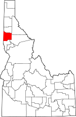
Latah County, Idaho Basics:


Latah County Idaho - Government Site

Population: 38,055
Area: 1076 square miles
County seat: Moscow
Area code(s) in use: 208
Time zone: PST
High school graduate or higher: 94.6%
Bachelor's degree or higher: 42.9%
Median household income: $39,466
Persons in poverty: 21.8%
Home ownership rate: 55.2%
Mean travel time to work: 18.1 minutes


Adjacent counties:
Benewah  Clearwater  Nez Perce  Shoshone  Whitman (WA)  
Find in Idaho

Map of the Latah County area


Our detail map of Latah County shows the Latah County, Idaho boundary lines and other interesting items.

Places in Latah County, Idaho

  Airports     show all on map

Anderson-Plummer Airport, Fountains Airport, Halls Hilltop Landing Strip, University of Idaho Heliport

  Areas     show all on map

Emerald Creek Garnet Area

  Buildings     show all on map

Appaloosa Horse Club and Museum, Aspendale Community Hall, Bovill Fire Department, Canterbury Hall, Central Fire Station, Chrisman Hall, Deary Rural Fire District, French Hall, Genesee Fire Department, Hotel Moscow, J K Ambulance, Juliaetta Volunteer Fire Department, Kendrick Volunteer Fire Department, Kenworthy Theatre, Latah County Courthouse, Latah County Jail, Latah County Sheriff's Office, Lindley Hall, McConnell Hall, Morrill Hall, Moscow City Hall, Moscow Police Department, Moscow Police Department University of Idaho, Moscow Rural Fire Department, Moscow Volunteer Fire Department Station 1, Moscow Volunteer Fire Department Station 2, Moscow Volunteer Fire Department Station 3, Moscow-Latah County Library, Potlatch Rural Fire District, Ridenbaugh Hall, Troy Fire and Ambulance, Troy Police Department, Willis Sweet Hall

  Cemeteries     show all on map

American Ridge Cemetery, Bethany Cemetery, Bethel Cemetery, Beulah Cemetery, Blaine Cemetery, Bovill Cemetery, Buchanan Cemetery, Burnt Ridge Cemetery, Cordelia Lutheran Cemetery, Dry Creek Cemetery, Elwood Cemetery, Fix Ridge Cemetery, Freeze Cemetery, Genesee Valley Lutheran Cemetery, Gold Hill Cemetery, Juliaetta Cemetery, Kendrick Cemetery, Little Bear Ridge Cemetery, Mendenhall Cemetery, Moscow Cemetery, Overacker Cemetery, Pine Crest Cemetery, Rock Creek Cemetery, Saint Johns Lutheran Cemetery, Spencer Cemetery, Sunset Memorial Gardens Cemetery, Wild Rose Cemetery, Woodfell Cemetery, Zion Cemetery

  Census     show all on map

Princeton Census Designated Place

  Churches     show all on map

Church of God, Church of the Nazarene, Emmanuel Lutheran Church, First Baptist Church, First Church of Christ Scientist, First Presbyterian Church, First United Methodist Church, Grace Baptist Church, Our Saviors Lutheran Church, Saint Marks Episcopal Church, Saint Marys Roman Catholic Church, Seventh Day Adventist Church

  Dams     show all on map

Moose Creek Dam, Spring Valley Dam, Troy Dam

  Flats     show all on map

Bronson Meadow, Browns Meadow, Cougar Meadows, Dutch Flat, Erickson Meadow, Graves Meadow, Haskins Flat, Hog Meadow, Long Meadow, Macumber Meadows, Mason Meadows, Missouri Flat, Moose Meadows, Randall Flat, Rowlands Park, Shea Meadows, Smith Meadows, Smith Meadows, Tee Meadow, Vassar Meadows, Wet Meadows

  Hospitals     show all on map

Gritman Medical Center

  Lakes     show all on map

Atwater Lake

  Locales     show all on map

Ayer, Bovard Station, Browns Camp, Camp Grizzly, Cedar Grove Camp, Cornell Station, Cove, East Gold Lookout, East Moscow Lookout, Emerald Creek Campground, Estes Station, Jacks Gulch (historical), Kennedy Ford, Kings Landing, Korns Shopping Center, Lamarack Ski Area, Little Boulder Campground, Morrissey Siding, Moscow Mall, Moscow Mountain Picnic Area, Mountain Home Grange, Palouse District Ranger Station, Palouse Empire Mall, Park, Poe, Purdue, Sherwin Station, Spring Valley Recreation Site, Spring Valley Reservoir Public Fishing Area, Thorn Creek Ranch, Wagon Town Hill, Wellesley

  Mines     show all on map

Bonami Number 1 Mine, Carrico Mine, Doer Mine, Gold Bug Mine, Gold Hill Mine, Last Chance Mine, Lost Wheelbarrow Mine, Luella Mine, Mizpah Mine, Olson Mine, Silver King Mine, White Cross Mine

  Parks     show all on map

Laird Park, Mary Minerva McCroskey Memorial State Park, Neale Stadium (historical), Roadside Park

  Populated Places     show all on map

Advent Hollow (historical), Aspendale, Avon, Blaine, Bovard (historical), Bovill, Buswell (historical), Chambers (historical), Cora, Cornwall, Crescent, Deary, Estes, Freeze, Genesee, Hampton, Harvard, Helmer, Howell, Jamestown (historical), Joel, Juliaetta, Kendrick, Lenville, Lidyville (historical), Linden, Moscow, Mountain Home (historical), Nora, Onaway, Orchard Homes (historical), Potlatch, Potlatch Junction, Princeton, Sherwin, Slabtown, Stanford, Troy, Vassar, Viola, Yale (historical), Yellow Dog (historical)

  Post Offices     show all on map

Moscow Post Office

  Ranges     show all on map

Hoodoo Mountains, Palouse Range

  Reserves     show all on map

Aspendale Wildlife Habitat Area, Paradise Wildlife Habitat Area, University of Idaho Experimental Forest

  Reservoirs     show all on map

Moose Creek Reservoir, Robinson Lake, Spring Hill Reservoir, Spring Valley Reservoir, Village of Troy Reservoir

  Ridges     show all on map

American Ridge, Big Bear Ridge, Burnt Ridge, Driscoll Ridge, Dry Ridge, Fix Ridge, Huffman Ridge, Little Bear Ridge, Norwegian Ridge, Paradise Ridge, Strychnine Ridge, Tamarack Ridge, Texas Ridge, Viola Ridge

  Schools     show all on map

A B McDonald Elementary School, Bovill Elementary School, Deary School, Genesee Elementary School, Genesee Junior-Senior High School, J Russell Elementary School, Juliaetta Elementary School, Kendrick Junior-Senior High School, Lena Whitmore Elementary School, Moscow Junior High School, Moscow Senior High School, Mountain Home School, Palouse Hills Seventh-Day Adventist School, Potlatch Elementary School, Potlatch Junior-Senior High School, Saint Marys School, Saint Roses School, Troy Elementary School, Troy Junior-Senior High, University of Idaho, West Park Elementary School

  Springs     show all on map

Mission Spring (historical)

  Streams     show all on map

Arson Creek, Bedbug Creek, Bergs Creek, Big Bear Creek, Big Creek, Big Meadow Creek, Big Sand Creek, Blakes Fork, Bluejacket Creek, Bonami Creek, Boulder Creek, Boulder Creek, Brush Creek, Camas Creek, Cedar Creek, Chambers Creek, Chelsey Creek, Corral Creek, Cougar Creek, Cow Creek, Crane Creek, Crumarine Creek, Deep Creek, Disalto Creek, Dry Creek, Dry Fork, Dual Creek, Duffield Creek, East Fork Big Bear Creek, East Fork Big Creek, East Fork Corral Creek, East Fork Deep Creek, East Fork Flat Creek, East Fork Gold Creek, East Fork Little Hawk Creek, East Fork Meadow Creek, East Fork Potlatch River, East Fork Rock Creek, Feather Creek, Felton Creek, Fern Creek, Flannigan Creek, Flat Creek, Flat Creek, Fourmile Creek, Fry Creek, Gnat Creek, Gnat Creek, Gold Creek, Graves Creek, Grouse Creek, Hatter Creek, Head Creek, Headlong Creek, Hidden Creek, Highline Creek, Hog Meadow Creek, Hope Creek, Hoteling Creek, Howard Creek, Howell Creek, Hyaak Creek, Idlers Rest Creek, Ipsoot Creek, Jackson Creek, Jerome Creek, Johnson Creek, Kauder Creek, Kiwa Creek, Klawa Creek, Kywa Creek, Laguna Creek, Lamb Creek, Last Chance Creek, Lemman Creek, Leopold Creek, Little Bear Creek, Little Bear Creek, Little Boulder Creek, Little East Fork Emerald Creek, Little Hawk Creek, Little Sand Creek, Little Thorn Creek, Long Creek, Lost Creek, Mannering Creek, Maple Creek, McGary Creek, Meadow Creek, Middle Fork Big Bear Creek, Middle Fork Deep Creek, Middle Potlatch Creek, Missouri Flat Creek, Mizpah Creek, Moose Creek, Morrisey Creek, Mount Deary Creek, Nat Brown Creek, Nelson Creek, Nora Creek, North Fork Palouse River, North Fork Pine Creek, Olevan Creek, Papoose Creek, Pardus Creek, Pasture Creek, Piah Creek, Piccolo Creek, Pig Creek, Pine Creek, Pittwood Creek, Poorman Creek, Porcupine Creek, Post Creek, Prospect Creek, Pup Creek, Purdue Creek, Quartz Creek, Queener Creek, Randall Flat Creek, Reservoir Creek, Riswold Creek, Rock Creek, Rock Creek, Round Meadow Creek, Ruby Creek, Ruby Creek, Schwartz Creek, Secunda Creek, Sheep Creek, Slate Creek, South Fork Pine Creek, Spring Valley Creek, Stephens Creek, Strychnine Creek, Swamp Creek, Sypah Creek, Talapus Creek, Thorn Creek, Three Bear Creek, Torpid Creek, Triplet Creek, Twin Creek, Waterhole Creek, Wepah Creek, West Fork Big Bear Creek, West Fork Corral Creek, West Fork Deep Creek, West Fork Flannigan Creek, West Fork Little Bear Creek, West Fork Little Hawk Creek, West Fork Potlatch River, West Fork Rock Creek, White Pine Creek, Wolf Creek, Yakala Creek

  Summits     show all on map

Abes Knob, Baby Grand Mountain, Bald Mountain, Ball Butte, Basalt Hill, Beals Butte, Bean Hill, Benson Hill, Boundary Point, Caterpillar Hill, Cherry Butte, East Gold Hill, East Moscow Mountain, East Twin, Emerald Butte, Farber Point, Flynn Butte, Gold Hill, Gold Hill, Granite Point, Green Knob, Huckleberry Mountain, Little Bald Mountain, Little Sand Mountain, Lone Jack Mountain, Mason Butte, McGary Butte, Mica Mountain, Mineral Mountain, Mission Mountain, Moon Hill, Moscow Mountain, Mount Margaret, Palmer Butte, Paradise Point, Potato Hill, Prospect Peak, Randall Butte, Rocky Point, Sand Mountain, Sherwin Point, Stanford Point, Steakhouse Hill, Stratton Butte, Three Tree Butte, Tomer Butte, Turnbow Point, West Emerald, West Twin

  Towers     show all on map

KRFA-FM (Moscow), KRPL-AM (Moscow), KUID-TV (Moscow), KUOI-FM (Moscow), KZFN-FM (Moscow)

  Trails     show all on map

Sand Mountain Lookout Trail, White Pine National Recreation Trail

  Valleys     show all on map

Akers Gulch, Banks Gulch, Beagle Gulch, Bethel Canyon, Brady Gulch, Cabin Gulch, California Gulch, Cleveland Gulch, Eldorado Gulch, Excavation Gulch, Garden Gulch, Garnet Gulch, Greenhorn Gulch, Heath Gulch, Hoodoo Gulch, Linn Gulch, Longfellow Gulch, McCloud Gulch, McCoy Gulch, Moscow Gulch, Mountain Gulch, Paradise Valley, Pee Wee Gulch, Picnic Gulch, Plowman Gulch, Stria Gulch, Treasure Gulch, Turnbow Gulch, Wagner Gulch, White Pine Gulch,

Latah County, Idaho Population By Race (2012 estimate)

RacePopulation
WhiteLatah County White population 35,65835,657  
MixedLatah County Mixed population 951951
AsianLatah County Asian population 723723
BlackLatah County Black population 342342
American IndianLatah County American Indian population 304304
Hawaiian & Pacific IslanderLatah County Hawaiian & Pacific Islander population 7676

Additional population tables :
State population table
Idaho population by county