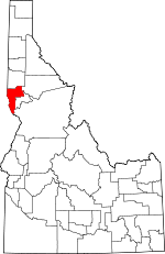
Nez Perce County, Idaho Basics:


Nez Perce County Idaho - Government Site

Population: 39,580
Area: 848 square miles
County seat: Lewiston
Area code(s) in use: 208
Time zone: PST
High school graduate or higher: 89.5%
Bachelor's degree or higher: 20.8%
Median household income: $45,587
Persons in poverty: 11.6%
Home ownership rate: 67.1%
Mean travel time to work: 16.3 minutes


Adjacent counties:
Asotin (WA)  Clearwater  Idaho  Latah  Lewis  Wallowa (OR)  Whitman (WA)  
Find in Idaho

Map of the Nez Perce County area


Our detail map of Nez Perce County shows the Nez Perce County, Idaho boundary lines and other interesting items.

Places in Nez Perce County, Idaho

  Airports     show all on map

Lewiston Airport, Saint Josephs Regional Medical Center Heliport, Snake River Seaplane Base, Wood Brothers Ranch Airport

  Arches     show all on map

The Ant and the Yellowjacket

  Bars     show all on map

Bear Bar, Bobcat Bar, Cougar Rapids Bar

  Beaches     show all on map

Amos Bench, Big Bench

  Bends     show all on map

Harpers Bend

  Bridges     show all on map

Clearwater River Memorial Bridge

  Buildings     show all on map

Big Canyon Fire District, Culdesac Quick Response Unit, Culdesac Volunteer Fire Department, Lapwai Volunteer Fire Department, Lewiston Fire Department Station 1, Lewiston Fire Department Station 2, Lewiston Fire Department Station 4, Lewiston Police Department, Lewiston Police Training Center, Nez Perce County Fire Department, Nez Perce County Fire Department, Nez Perce County Sheriff's Office, Potlatch Corporation Fire and Rescue Department, Wheatland Volunteer Fire Department

  Canals     show all on map

Sweetwater Canal, Webb Creek Canal

  Capes     show all on map

Rattlesnake Point

  Cemeteries     show all on map

Angel Ridge Cemetery, Glasby Cemetery, Indian Cemetery, Kendrick Cemetery, Leland Cemetery, Lenora Cemetery, Lewis and Clark Memorial Gardens, Melrose Cemetery, Old Good Hope Cemetery, Peck Cemetery, Red Elk Cemetery, Sunnyside Cemetery, Sweetwater Cemetery, Tammany Cemetery

  Census     show all on map

Sweetwater Census Designated Place

  Churches     show all on map

Good Hope Church

  Cliffs     show all on map

Fir Bluff, Limestone Point

  Dams     show all on map

Reservoir A Dam, Soldiers Meadow Dam, Sunset Palisades Dam, Thompson Dam

  Flats     show all on map

Benton Meadows, Kruze Meadows, Larabee Meadows

  Hospitals     show all on map

River Crest Hospital, Saint Joseph Regional Medical Center

  Islands     show all on map

Fir Island, Hog Island, Holbrook Island

  Lakes     show all on map

Blue Lake, Hidden Lake, Lake Waha, Mud Lake

  Locales     show all on map

Black Pine Campground, Bundy Station, Captain John Ferry, Cherrylane Station, China Garden, Dolomite Siding, Fir Bluff Station, Jacques Spur, Jacques Station, Lewiston Golf and Country Club, Lewiston Shopping Center, Lookout, Madden Corral, Mann Lake Public Fishing Area, Myrtle Access, Nez Perce County Farm, North Idaho Indian Agency, Peck Access Area, Southgate Plaza, Summit, Sunset Center, Sweetwater Hatchery, Waha Lake Access Area

  Military     show all on map

Fort Boise (historical)

  Mines     show all on map

Deer Creek Mine

  Parks     show all on map

Airway Park, Hells Gate State Recreation Area, Lapwai State Game Farm, Mark Means Park, Nez Perce National Historic Park - Spalding Area, Vollmer Park, William Craig Historical Monument

  Populated Places     show all on map

Agatha, Arrow, Beeman, Big George, Bundy, Cameron, Cherrylane, Chesley, Culdesac, Eugene, Fairburn (historical), Forebay, German Settlement, Gifford, Gurney, Hatwai, Jacques, Joseph, Lapwai, Leland, Lenore, Leon, Lewiston, Lewiston Orchards, Melrose, Myrtle, North Lapwai, North Lewiston, Peck, Snow (historical), Southwick, Spalding, Sweetwater, Taney (historical), Taplin, Transfer, Valley View Heights, Waha, Webb, Willola, Woodside, Zaza

  Rapidss     show all on map

Buffalo Rapids, Captain John Rapids, Captain Lewis Rapids, Cochran Rapids, Cougar Rapids, Frenchy Rapids, Lower Cache Creek Rapids, Lower Cache Creek Rapids, Negro Head Rapids, Shovel Creek Rapids, Tenmile Rapids, Tenmile Rapids, Wild Goose Rapids

  Reserves     show all on map

Craig Mountain Wildlife Management Area

  Reservoirs     show all on map

Mann Lake, Soldiers Meadow Reservoir

  Ridges     show all on map

Angel Ridge, Cream Ridge, Fort Simons Ridge, Frye Point, Lower Cream Ridge, McCormack Ridge, Polly Ridge, Potlatch Ridge, Potlatch Ridge, Wapshilla Ridge, Webb Ridge

  Schools     show all on map

Beacon School, Camelot Elementary School, Cavendish-Teakean Elementary School, Culdesac School, Garfield School, Jenifer Junior High School, Lapwai Elementary School, Lapwai Middle-High School, Lewis-Clark State College, Lewiston Senior High School, McGhee Elementary School, McSorley Elementary School, Northwest Childrens Home Education Center, Orchards Elementary School, Peck Elementary School, Sacajawea Junior High School, Saint Stanislaus Tri-Parish School, Shiloh Schools, Tammany Elementary - Junior High School, Teakean-Cavendish School, Webster Elementary School, Whitman Elementary School

  Springs     show all on map

Howerton Spring, Roberts Spring

  Streams     show all on map

Banks Creek, Bedrock Creek, Big Canyon Creek, Big Cougar Creek, Billy Creek, Birch Creek, Browns Creek, Camp Creek, Captain John Creek, Catholic Creek, Chimney Creek, China Creek, China Garden Creek, Clearwater River, Corral Creek, Cottonwood Creek, Cottonwood Creek, Cow Creek, Coyote Creek, Dough Creek, Eagle Creek, East Fork Sweetwater Creek, First Creek, First Creek, Fourth Creek, Frenchy Creek, Hatwai Creek, Jacks Creek, Lake Creek, Lapwai Creek, Lindsay Creek, Little Canyon Creek, Little Cougar Creek, Little Potlatch Creek, Lone Pine Creek, Louse Creek, Madden Creek, Magpie Creek, McGuire Creek, Middle Creek, Middle Fork Tom Beall Creek, Mill Creek, Mission Creek, North Fork Tom Beall Creek, Pine Creek, Potlatch River, Redbird Creek, Rock Creek, Salmon River, Second Creek, South Fork Birch Creek, South Fork Captain John Creek, South Fork Tom Beall Creek, Star Mill Creek, Swamp Creek, Sweetwater Creek, Tammany Creek, Third Creek, Tom Beall Creek, Wapshilla Creek, Webb Creek, West Fork Deer Creek, West Fork Sweetwater Creek

  Summits     show all on map

Craig Mountain, Culdesac Hill, Gold Hill, Lewiston Hill, Pigeon Roost, Teakean Butte, Thunder Hill

  Valleys     show all on map

Beardy Gulch, Beaver Canyon, Buffalo Draw, Cave Gulch, Cole Canyon, Coyote Gulch, Crowers Canyon, Garden Gulch, Half Moon Draw, Homestead Canyon, Howard Gulch, Hubbard Gulch, Lapwai Valley, Lyle Gulch, Nichols Canyon, Packers Gulch, Pickle Canyon, Polly Canyon, Pruitt Draw, Rattlesnake Canyon, Short Canyon, Short Canyon, Sixmile Canyon, Soldiers Canyon, Taylor Canyon, Tenmile Canyon, Thiessen Canyon, Thiessen Gulch, Wauncher Gulch, Wheeler Canyon,

Nez Perce County, Idaho Population By Race (2012 estimate)

RacePopulation
WhiteNez Perce County White population 35,82035,819  
American IndianNez Perce County American Indian population 2,2562,256
MixedNez Perce County Mixed population 950949
AsianNez Perce County Asian population 317316
BlackNez Perce County Black population 198197
Hawaiian & Pacific IslanderNez Perce County Hawaiian & Pacific Islander population 4039

Additional population tables :
State population table
Idaho population by county