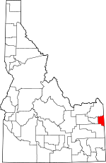
Teton County, Idaho Basics:


Teton County Idaho - Government Site

Population: 10,069
Area: 449 square miles
County seat: Driggs
Area code(s) in use: 208
Time zone: MST
High school graduate or higher: 88.1%
Bachelor's degree or higher: 33.3%
Median household income: $56,532
Persons in poverty: 8.5%
Home ownership rate: 69.9%
Mean travel time to work: 26.4 minutes


Adjacent counties:
Bonneville  Fremont  Madison  Teton (WY)  
Find in Idaho

Map of the Teton County area


Our detail map of Teton County shows the Teton County, Idaho boundary lines and other interesting items.

Places in Teton County, Idaho

  Airports     show all on map

Driggs Teton Peaks Municipal Airport, Teton Peaks Airport

  Areas     show all on map

Three Forks

  Basins     show all on map

Center Basin, Horse Heaven, Packsaddle Basin, Teton Basin

  Bends     show all on map

Big Bend, Rainbow Bend, Rotten Bottom

  Bridges     show all on map

Bates Bridge, Buxton Bridge, White Bridge

  Buildings     show all on map

Teton County Fire Protection District Station 1, Teton County Fire Protection District Station 2, Teton County Fire Protection District Station 3, Teton County Sheriff's Office

  Canals     show all on map

Center Canal, Cherry Grove Canal, Edison and Ricks Canal, Grand Teton Canal, Haden Canal, Hog Canal, Humble Canal, Kearsley Canal, Kilpack Canal, Kimball Canal, North Leigh Canal, Spencer Canal, String Canal, Tonks Canal

  Cemeteries     show all on map

Bates Cemetery, Cache Clawson Cemetery, Cedron Cemetery, Driggs Cemetery, Driggs-Darby Cemetery, Felt Cemetery, Haden Cemetery, Victor Cemetery

  Cliffs     show all on map

Grandview Point

  Dams     show all on map

Felt Dam, Linderman Dam

  Flats     show all on map

Elk Flat

  Forests     show all on map

Targhee National Forest

  Gaps     show all on map

Blacktail Pass, Government Trail Pass, Pine Creek Pass, Piney Pass

  Hospitals     show all on map

Teton Valley Hospital

  Lakes     show all on map

Alligator Lake, Castle Lake, Crystle Lake, Packsaddle Lake

  Locales     show all on map

Badger Creek Access Area, Fox Creek East Access Area, Fox Creek West Access Area, Linderman Ranch, Mike Harris Camnpground, Nickerson Bridge Access Area, Pine Creek Campground, Rainer Access Area, Spud Drive-In, Teton Creek Access Area, Weir

  Mines     show all on map

Brown Bear Mine, Hillman Mine, Idaho Mine, Mikesell Mine, Packsaddle Mine, Pintar Mine, Superior Mine, Walton Mine

  Pillars     show all on map

Castle Rock

  Populated Places     show all on map

Bates, Cache, Cedron, Chapin, Clawson, Clementsville, Darby, Driggs, Felt, Fox Creek, Haden (historical), Judkins, Sam, Tetonia, The String, Twin Forks, Two Forks, Victor

  Ranges     show all on map

Big Hole Mountains

  Reservoirs     show all on map

Lizard Lake, McRenolds Reservoir, Mud Lake

  Ridges     show all on map

Blanchard Ridge, Boquet Ridge, Idaho Ridge, Long Ridge, Patterson Ridge, Relay Ridge, Twin Creek Ridge

  Schools     show all on map

Bates School, Teton High School, Teton Middle School, Tetonia Elementary School, Univ of Idaho Agr Experiment Station, Victor Elementary School

  Springs     show all on map

Bex Spring, Boquet Springs, Buck Spring, Crandall Spring, Graham Spring, Hands Spring, Neville Spring, Packsaddle Spring, Paradise Spring, Sherman Springs

  Streams     show all on map

Allen Creek, Badger Creek, Bell Creek, Bitch Creek, Blacktail Creek, Boquet Creek, Brown Bear Creek, Bull Elk Creek, Coalmine Fork, Darby Creek, Dick Creek, Drake Creek, Dry Creek, Dry Creek, Dry Fork, Dude Creek, Elk Flat Fork, Elliott Creek, Fish Creek, Foster Slough, Fox Creek, Game Creek, Government Fork, Grouse Creek, Grove Creek, Henderson Creek, Hill Creek, Hillman Creek, Horse Creek, Horseshoe Creek, Irene Creek, Johns Creek, Juniper Creek, Little Dry Creek, Little Pine Creek, Lookingglass Creek, Mahogany Creek, Middle Leigh Creek, Middle Twin Creek, Mike Harris Creek, Milk Creek, Moose Creek, Morris Creek, Murphy Creek, North Badger Creek, North Fork Canyon Creek, North Fork Horseshoe Creek, North Fork Mahogany Creek, North Fork Packsaddle Creek, North Leigh Creek, North Twin Creek, Packsaddle Creek, Paradise Creek, Patterson Creek, Porcupine Creek, Sorensen Creek, South Badger Creek, South Fork Canyon Creek, South Fork Horseshoe Creek, South Fork Mahogany Creek, South Fork Packsaddle Creek, South Fork Patterson Creek, South Leigh Creek, South Twin Creek, Spring Creek, Spring Creek, Steep Creek, Superior Creek, Swanner Creek, Tepee Creek, Teton Creek, Trail Creek, Warm Creek, Warm Creek, Wildcat Creek, Woods Creek, Yellow Creek

  Summits     show all on map

Baldy Knoll, Garns Mountain, Henderson Peak, Monument Peak, Mount Manning, Oliver Peak, Piney Peak, Red Mountain, Rocky Peak, Ryan Peak, Squirrel Mountain, Susies Nipple, Temple Peak, Thunder Mountain

  Trails     show all on map

De Coster Trail

  Valleys     show all on map

Allen Canyon, Blind Canyon, Buttermilk Draw, Coyote Canyon, Drake Canyon, Dry Hollow, Idaho Canyon, Log Hollow, Mikesell Canyon, Mine Canyon, Nordell Canyon, Pintar Canyon, Pole Canyon, Pole Canyon, Rammell Hollow, Rock Hollow, Smith Canyon, Sob Canyon, Stateline Canyon, Station Gulch, Sweet Hollow, Sweetwater Canyon, Thousand Springs Valley, Wiggleton Hollow, Wood Canyon, Woods Hollow,

Teton County, Idaho Population By Race (2012 estimate)

RacePopulation
WhiteTeton County White population 9,8079,807  
MixedTeton County Mixed population 121120
American IndianTeton County American Indian population 5050
AsianTeton County Asian population 4040
BlackTeton County Black population 3030
Hawaiian & Pacific IslanderTeton County Hawaiian & Pacific Islander population 2020

Additional population tables :
State population table
Idaho population by county