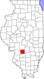
Bond County, Illinois Basics:
Bond County Illinois - Government Site
Population: 17,612
Area: 380 square miles
County seat: Greenville
Area code(s) in use: 618 217
Time zone: CST
High school graduate or higher: 87.1%
Bachelor's degree or higher: 20.2%
Median household income: $47,705
Persons in poverty: 13.5%
Home ownership rate: 77.5%
Mean travel time to work: 22.2 minutes
Adjacent counties:
Clinton Fayette Madison Montgomery
Places in Bond County, Illinois
Edw A Utlaut Memorial Heliport,
Greenville Airport,
Mueller Airport,
Nance Airport,
Smith RLA Ultralight Flightpark American Farm Heritage Museum,
Bond County Courthouse,
Bond County Emergency Medical Services,
Bond County Jail,
Federal Correctional Institution Greenville,
Greenville City Hall,
Greenville Fire Protection District,
Greenville Public Library,
Highland - Pierron Fire Protection District Station 1,
Hogue Hall,
Janssen Hall,
Keyesport Fire Protection District,
Memorial Library,
Mulberry Grove Fire Protection District,
Pocahontas - Old Ripley Fire Protection District Station 1,
Pocahontas - Old Ripley Fire Protection District Station 2,
Shoal Creek Fire Protection District Station 1,
Smithboro Fire Protection District Bethel Cemetery, Blanchard Cemetery, Britt Cemetery,
Brown Cemetery, Browning Cemetery,
Burgess Cemetery, Calvin Brown Cemetery, Corrington Cemetery,
Coyle Cemetery, Dewey Cemetery,
Duncan Cemetery,
Dunkard Cemetery,
Durham Cemetery,
Durr Cemetery, Eakin Cemetery,
Elm Point Cemetery, Enloe Cemetery,
Etcheson Cemetery,
File Cemetery, George Neathery Cemetery, Glenn Cemetery,
Greene Cemetery, Gum Cemetery,
Halls Grove Cemetery, Harris Cemetery,
Hastings Cemetery,
Hazel Dell Cemetery,
Hazel Dell Cemetery, Hills Fort Cemetery, Hookdale Cemetery, Hubbard Burial Ground, Hubbard Number 1 Cemetery,
Hug Cemetery, Hunter Cemetery, Jett Number 2 Cemetery,
Jett Number Cemetery, John Cruthis Cemetery, Kirkland Cemetery, Largent Cemetery, Laws Number 1 Cemtery, Laws Number 2 Cemetery,
Liberty Cemetery, Little Cemetery, Maxel Cemetery,
Maxey Cemetery,
McKendree Cemetery, Messinger Cemetery,
Mitchell Cemetery, Mithcell Farm Cemetery,
Montrose Cemetery, Montrose Mausoleum, Moody Cemetery,
Mount Auburn Cemetery,
Mount Gilead Cemetery,
Mount Moriah Cemetery,
Mount Nebo Old Cemetery,
Mulberry Grove Cemetery,
Neathery Cemetery,
New Mount Nebo Cemetery,
Noffsinger Cemetery, O'Byrne Cemetery,
Old City Cemetery, Old Diamond Cemetery, Old Ripley Cemetery,
Payne Cemetery,
Peterson Cemetery, Pocahontas Cemetery, Pritchett Cemetery, Rawson Cemetery, Rhea Cemetery, Rising Cemetery,
Robinson Cemetery,
Saint Lawrence Catholic Cemetery,
Saint Nicholas Cemetery,
Saint Peters Cemetery,
Seagraves Cemetery, Shoal Creek Cemetery,
Smith Grove Cemetery,
Snow Cemetery, Sorento Cemetery, Spies Cemetery,
Sugg Number 1 Cemetery, Sugg Number 2 Cemetery,
Sunny Side Cemetery, Sybert Cemetery, Taylor Cemetery,
Tisdale Cemetery, Tobias File Cemetery,
Union Cemetery,
Union Grove Cemetery, Vaughn Cemetery,
Wade Cemetery,
Weinheimer Cemetery,
Wisetown Cemetery,
Wright Cemetery, WSiliam Cemetery
Campground Church,
Centenary Church (historical),
Faith Chapel,
Fellowship Baptist Church,
First Baptist Church,
First Baptist Church,
First Christian Church (historical),
First Church of Christ,
First Methodist Church (historical),
First Presbyterian Church,
First Southern Baptist Church (historical),
First United Methodist Church,
Free Methodist Church,
Grace Episcopal Church,
Kingdom Hall of Jehovahs Witnesses,
Liberty Church,
McKendree Chapel (historical),
Mount Carmel Church (historical),
Mount Gilead Church,
Mount Nebo Church,
Mount Tabor Church,
Our Redeemer Lutheran Church,
Pentecostal Assembly of God Church (historical),
Plymouth Church,
Saint Lawrence Catholic Church,
Smith Grove Church,
True Vine Baptist Church (historical),
Wilkerson Chapel African Methodist Episcopal Church,
Zion Church Interchange 36,
Interchange 41,
Interchange 45,
Interchange 52 Armstrong Pond Dam,
Bond Christan Camp Lake Dam,
Greenville New City Dam,
Greenville Old City Lake Dam,
Greenville Rod and Gun Club Lake Dam,
Potthast Lake Dam,
Rinco Instrument Corporation Lake Dam,
Sorento Reservoir Dam,
Stone Pond Dam,
Tomahawk Lake Dam Greenville Regional Hospital Black Diamond Farm,
Bond Camp,
Bond County Landfill,
Camp Shadrack,
Doll's Orchard,
Durley Camp,
Greenville Country Club,
Marcoot Jersey Farm,
Midwest Camp,
Parkview Farms,
Ready View Farms,
Rolling Lawns Farms,
Royal Lake Resort,
Shoal Creek Farm,
Stubblefield Gas Storage Field,
Tamalco Access Area Keyesport Pit,
Munie Pit Beaver Creek Oil Field,
Old Ripley Oil Field,
Woburn Consolidated Oil Field Bond County Fairground,
Greenville Park,
Jaycee Park Ayers,
Beaver Creek,
Bunje,
Dudleyville,
Durley,
Elm Point (historical),
Gilmore,
Greenville,
Hamburg,
Hookdale,
Keyesport Landing,
Mulberry Grove,
Old Ripley,
Paisley Corners,
Panama,
Pauls Friendly City Mobile Home Park,
Pierron,
Pierron,
Pleasant Mound,
Pocahontas,
Reno,
Smithboro,
Sorento,
Stubblefield,
Tamalco,
Woburn Greenville Post Office,
Pleasant Prairie Post Office (historical),
Tamalco Post Office (historical) Armstrong Pond,
Bond Christian Camp Lake,
Governor Bond Lake,
Greenville Lake,
Greenville New City Lake,
Greenville Old City Lake,
Greenville Rod and Gun Club Lake,
Lake Lola,
Potthast Lake,
Rinco Instrument Corporation Lake,
Sorento Reservoir,
Stone Pond,
Tomahawk Lake Barr School (historical),
Betterton School (historical),
Blackjack School (historical),
Bond County Community High School,
Brick School (historical),
Britt School (historical),
Carthill School (historical),
Chapel Hill School (historical),
Cherry Grove School (historical),
Concord School (historical),
Crab Apple School (historical),
Crossno School (historical),
Drake School (historical),
Duncan School (historical),
Elm Point School (historical),
Fuller School (historical),
Gilham School (historical),
Greenville Central Public School (historical),
Greenville College,
Greenville Elementary School,
Greenville Junior High School,
Griggs School (historical),
Halls Grove School (historical),
Hampton School (historical),
Harned School (historical),
Harris School (historical),
Hesse School (historical),
Hopewell School (historical),
Hubbard School (historical),
Hunter School (historical),
Inglis Public School (historical),
LaGrange School (historical),
Lindly School (historical),
Little Brick School (historical),
Mahle School (historical),
Marti School (historical),
McCord School (historical),
Metcalf School (historical),
Mount Vernon School (historical),
Muddy School (historical),
Mulberry Grove Senior High School,
Myatt School (historical),
Neathery School (historical),
Oak Grove School (historical),
Palmer School (historical),
Persimmon Grove School (historical),
Pin Oak School (historical),
Plant School (historical),
Pleasant Grove School (historical),
Pleasant View School (historical),
Pocahontas Center,
Potts School (historical),
Ray School (historical),
Rhea School (historical),
Rogers School (historical),
Round Prairie School (historical),
Seagraves School (historical),
Shady Grove School (historical),
Shawnee School (historical),
Shoal School (historical),
Sinai School (historical),
Smith Grove School (historical),
Smith School (historical),
Sorento Elementary School,
Terrapin Ridge School (historical),
Union Grove School (historical),
Union School (historical),
Willis School (historical),
Willow Branch School (historical) Avery Branch,
Dorris Creek,
Dry Branch,
Dry Fork,
East Fork Shoal Creek,
Elm Point Branch,
Flat Creek,
Indian Creek,
Indian Creek,
Keysport Branch,
Kingsbury Branch,
Little Beaver Creek,
Little Dry Fork,
Locust Fork,
Spring Branch,
Yankee Creek WGEL-FM (Greenville),
WGRN-FM (Greenville),

