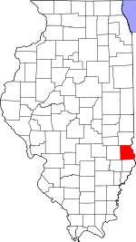
Crawford County, Illinois Basics:
Crawford County Illinois - Government Site
Population: 19,605
Area: 444 square miles
County seat: Robinson
Area code(s) in use: 618
Time zone: CST
High school graduate or higher: 88.2%
Bachelor's degree or higher: 15.6%
Median household income: $44,617
Persons in poverty: 15.0%
Home ownership rate: 81.0%
Mean travel time to work: 18.5 minutes
Adjacent counties:
Clark Jasper Knox (IN) Lawrence Richland Sullivan (IN)
Places in Crawford County, Illinois
Crawford County Airport,
Crawford Memorial Hospital Heliport Horseshoe Cutoff Hutsonville Bridge,
Spencer Bridge (historical) Crawford County Courthouse,
Flat Rock Area Fire Protection District,
Hutsonville Power Station,
Hutsonville Township Fire Protection District,
Hutsonville Township Fire Protection District Station 2 West York,
Lamotte Township Fire Protection District,
Oblong Township Fire Protection District,
Palestine Public Library,
Prairie - Licking Fire Protection District,
Robinson City Hall,
Robinson Correctional Center,
Robinson Fire Department,
Robinson Township Public Library,
United Lifecare Ambulance Service Abshear Cemetery, Adams Cemetery, Afro-American Cemetery,
Allen Cemetery, Allison Cemetery,
Baker Cemetery,
Ball Cemetery, Banu Cemetery,
Barbee Cemetery,
Bartmess Cemetery, Bartmess Cemetery, Bathe Cemetery,
Beckwith Cemetery,
Bellair Cemetery,
Bennett Cemetery,
Berlin Cemetery, Berry Cemetery, Bowman Cemetery,
Bradbury Cemetery, Cannaan Cemetery,
Cecedar Cemetery, Clayton Cemetery, Connett Cemetery,
Cox Cemetery, Crawford County Poor Farm Cemetery, Crews Cemetery, Curtis Cemetery, Davis Cemetery, Dawson Cemetery,
Dickerson Cemetery,
Dix Cemetery, Dogwood Cemetery,
Draper Cemetery,
Duggan Cemetery,
Duncanville Cemetery, Dunlap Cemetery,
East Union Cemetery, Eaton Cemetery, Faught Cemetery,
Ferrell Cemetery,
Ford Cemetery,
Fuller Cemetery, Gaddis Cemetery,
Ganies Cemetery, Garrard Cemetery,
Good Hope Cemetery, Goodwin Cemetery, Gould Cemetery, Gowin Cemetery,
Green Cemetery,
Green Cemetery,
Green Hill Cemetery,
Guyer Cemetery,
Hale Cemetery, Hand Cemetery,
Hardinville Cemetery,
Harmony Cemetery, Haskins Cemetery, Henderson Cemetery,
Higgins Cemetery,
Higgins Cemetery, Hix Cemetery,
Hutson Old Cemetery,
Hutsonville New Cemetery, John Kent Cemetery,
Johnson Cemetery,
Jones Cemetery,
Jones Cemetery,
Keplinger Cemetery,
Kirk Cemetery,
Kitchell Cemetery,
Lackey Cemetery, Lackey Cemetery, Lagow Cemetery, Landes Cemetery, Leggitt Cemetery, Liberty Cemetery,
Lindley Cemetery, Logan Cemetery, Mace Cemetery,
Maddox Cemetery, Mail Cemetery, Mann Cemetery, Martin Cemetery, Milkeworth Cemetery,
Minnick Cemetery,
Morea Cemetery,
Mount Pleasant Cemetery,
Musgrave Cemetery,
Neathery Cemetery, Nethery Cemetery,
New Robinson Cemetery,
Newlin Cemetery,
Norton Cemetery,
Nuttle Cemetery,
Oak Grove Cemetery,
Oblong Cemetery, Oblong Cemetery,
Old Robinson Cemetery, Palestine Cemetery, Pleasant Grove Cemetery,
Pleasant View Cemetery,
Port Jackson Cemetery,
Prairie Grove Cemetery,
Prier Cemetery,
Prior Grove Cemetery, Rains Cemetery,
Randolph Cemetery,
Rich Cemetery,
Richart Cemetery, Ridge Cemetery, Robertson Cemetery,
Seaney Cemetery,
Sears Cemetery, Sears Cemetery,
Shaw Cemetery, Shimer Cemetery, Smith Cemetery, Smith Cemetery,
Stanfield Cemetery, Stephens Cemetery,
Swearingen Cemetery,
Tobey Cemetery,
Tohill Cemetery, Upike Cemetery,
Waggoner Cemetery,
Waggoner Cemetery, Waldrop Cemetery,
Wesley Chapel Cemetery,
White Oak Cemetery, Wiley Cemetery
Annapolis Census Designated Place,
West York Census Designated Place Hutsonville Cut Off Annapolis Christian Church,
Berlin Congregational Church,
Bible Chapel,
Canaan Primitive Baptist Church,
Central United Methodist Church,
Eureka Church,
Evangelical United Methodist Church,
First Baptist Church,
First Baptist Church,
First Baptist Church of Oblong,
First Christian Church,
First Christian Church,
First United Methodist Church,
Grace Church,
Grand Prairie Church,
Green Hill Church,
Hutsonville Church,
Kirk Chapel United Methodist Church,
Lamotte Prairie Church,
Leeper Church,
Mount Pleasant Church (historical),
New Harmony Church (historical),
New Hebron Baptist Church,
Newlight Church (historical),
Oak Grove Church,
Otterbein United Methodist Church,
Our Lady of Lourdes Church,
Pearl Chapel United Methodist Church,
Pleasant Grove Church,
Pleasant Grove Church,
Pleasant View Church,
Plymouth Christian Church,
Prairie Church,
Prairie Grove Church,
Prior Grove Baptist Church,
Saint Elizabeth Catholic Church,
Seed Chapel,
Swaringen Church,
Union Church,
Victory Church (historical),
Willow Prairie Church (historical),
Zion Church Hite Ferry (historical),
Hutsonville Ferry (historical),
Smith Ford,
Yeager Ford (historical) Allen Lake Dam,
Athey Lake Dam,
Brooks Lake Dam,
Burcham Pond Dam,
Campbell Lake Dam,
Newlin Lake Dam,
Ridgeway Lake Dam,
West Lake Dam Crawford Memorial Hospital Eagle Island Circle Pond,
Horseshoe Pond,
Lake Walton,
Long Pond,
Oblong Lake,
Old Channel Lake Antoka Farms,
Bailey Farm,
Brightlight Ferry (historical),
Collier Farms,
Collier Farms,
Crane Hilltop Farm,
Crawford County Home,
Dart Farm,
Debatin Farms,
Dogwood Creek Farm,
Gibler Farms,
Goodwin Farms,
Gordon Goat Farm,
Green Meadow Acres,
Guyer Farms,
Harris Farms,
Holmes Farms,
Inboden Farms,
Lewis Farms,
Longtown Ferry (historical),
Lucky Ford Ferry (historical),
M and J Farms,
Manhart Farms,
Maple Creek Farms,
Meese Farms,
Mefford Farms,
Merom Ferry,
Miller Farms,
Musgrave Farms,
Newbold Farms,
Newell Farms,
Parker Farms,
Pifer Farms,
Quail Creek Country Club,
Rains Grain Farm,
Rich Pork Farm,
Ryan Farms,
Sackrider Farms,
Sand Rock Farm,
Shady Lane Fish Farm,
Shaws Landing,
Shew Farms,
Sholders Farms,
Stoner Farms,
Trimble Farms,
Triple F Farms,
Wardtbaugh Farms,
Weger Farm,
Wernze Farms,
Wilt Farm Bellair Oil Field,
Main Consolidated Oil and Gas Field,
Robinson Oil Field City Park,
Crawford County State Fish and Wildlife Area,
Leaverton Park,
Washington Park Annapolis,
Bellair,
Crawfordsville (historical),
Dogwood,
Duncanville,
Flat Rock,
Gordon,
Green Brier,
Hardinville,
Heathsville,
Hutsonville,
Kibbie,
Landes,
Morea,
New Hebron,
Oblong,
Oil Center,
Oil Grove,
Palestine,
Pierceburg,
Port Jackson,
Porterville,
Richwoods,
Robinson,
Stoy,
Trimble,
Villas,
West York Annapolis Post Office,
Eaton Post Office (historical),
Flat Rock Post Office,
Grand Glade Post Office (historical),
Oblong Post Office,
Palestine Post Office,
Robinson Post Office Allen Lake,
Athey Lake,
Brooks Lake,
Burcham Pond,
Campbell Lake,
Newlin Lake,
Ridgeway Lake,
West Lake Adams School (historical),
Altman School (historical),
Bend School,
Berlin School (historical),
Bottoms School (historical),
Brown School (historical),
Buncombe School (historical),
Canaan School (historical),
Cannon School (historical),
Castle School (historical),
Centennial School (historical),
Center School (historical),
Clark School (historical),
Eureka School (historical),
Henderson School (historical),
Higgins School (historical),
Hillsboro School (historical),
Hope School (historical),
Hurricane School (historical),
Hutsonville High School,
Jefferson School,
La Motte School (historical),
Lincoln Elementary School,
Lincoln Trail College,
Lindsay School (historical),
Lively School (historical),
Mann School (historical),
McCarthy School (historical),
McKiven School (historical),
Meskimmon School (historical),
Mills School (historical),
Monarch School (historical),
Montgomery School (historical),
Mount Pleasant School (historical),
Moyer School (historical),
Nuttall Middle School,
Oak Ridge School (historical),
Oblong Elementary School,
Oblong High School,
Palestine Grade School,
Palestine High School,
Prairie School (historical),
Price School (historical),
Robinson High School,
Star School (historical),
Taylor School (historical),
Union School (historical),
Victor School (historical),
Washington Elementary School,
Watts School (historical),
Wheeler School (historical),
Wilson School (historical) Bennett Creek,
Big Creek,
Brush Creek,
Dogwood Creek,
Elm Creek,
Freeport Creek,
Grassy Creek,
Hiser Creek,
Honey Creek,
Hutson Creek,
Lamotte Creek,
Little Creek,
Maple Creek,
Minnow Slough,
Muddy Creek,
No Business Creek,
Onion Creek,
Painter Fork,
South Fork Raccoon Creek,
Sugar Creek,
Sugar Creek,
Sugar Creek,
Sweet Creek,
West Branch Honey Creek,
Willow Creek Bristol Hill,
Indian Mound,
Shawn Hill WTAY-AM (Robinson),
WTAY-FM (Robinson),

