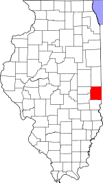
Edgar County, Illinois Basics:
Edgar County Illinois - Government Site
Population: 18,160
Area: 623 square miles
County seat: Paris
Area code(s) in use: 217
Time zone: CST
High school graduate or higher: 87.3%
Bachelor's degree or higher: 16.0%
Median household income: $42,730
Persons in poverty: 15.7%
Home ownership rate: 75.1%
Mean travel time to work: 23.0 minutes
Adjacent counties:
Champaign Clark Coles Douglas Vermilion Vermillion (IN) Vigo (IN)
Places in Edgar County, Illinois
Bussart Airport,
Edgar County Airport,
Ewing Landing Strip,
Glatthaar Airport,
Gough Airport,
Gough Landing Strip,
Hildreth Air Park,
Lamkey Landing Strip,
Midway Landing Field (historical),
Paris Airport (historical),
Paris Community Hospital Heliport,
Richardson Landing Strip,
Rowe Airport,
State Highway Paris Heliport,
Stewart Airport Brocton Fire Protection District,
Chrisman Fire Protection District,
Edgar County Courthouse,
Edgar County Special Service Area Ambulance,
Grandview Fire Department,
Hume Fire Protection District,
Kansas Ambulance Company,
Kansas Fire Protection District,
Metcalf Fire Protection District,
North Arm Community Center,
Northern Edgar County Ambulance Service,
Paris Fire Department,
Paris Fire Protection District - Oliver Fire Department,
Pine Grove Community Center,
Redmon Fire Department,
Symmes Townhall,
Vermilion Fire Department Drainage Ditch Number 2,
Drainage Ditch Number 7,
Shiloh Number 3 Drainage Ditch,
Shiloh Special Drainage Ditch Adams Cemetery,
Allen Cemetery, Asher Cemetery,
Augustus Cemetery, Augustus Cemetery, Baber Cemetery, Bacon Cemetery,
Barr-Johnson Cemetery,
Beatty Cemetery, Big Creek Cemetery,
Blackburn Cemetery,
Blackman Cemetery,
Bloomfield Cemetery,
Boyer Cemetery,
Boyer Cemetery, Boyer Cemetery, Breen Cemetery,
Bright Cemetery,
Bruce Cemetery, Burt Cemetery, Burton Cemetery, Bush Cemetery, Cale Cemetery,
Cameron Cemetery,
Cassady Cemetery,
Catfish Cemetery,
Catfish Point Cemetery,
Cherry Point Cemetery,
Cholera Cemetery,
Chronic Cemetery, Cockcroft Cemetery,
Conkey Cemetery,
Cook Cemetery,
Cornwell Cemetery,
Cummings Cemetery, Davis Cemetery, Davis Cemetery,
Edgar Cemetery,
Elledge Holley Cemetery,
Embarrass Cemetery,
Fairview Cemetery,
Franklin Cemetery, French Burial Grounds,
Gaines Cemetery,
Gill Cemetery,
Grandview Cemetery, Gray Cemetery, Green Cemetery,
Gymon Cemetery, Hand Cemetery, Harbol Cemetery,
Harmony Cemetery,
Hinds Cemetery,
Hoult Cemetery, Housel Cemetery,
Houseton Cemetery,
Huffman Cemetery,
Igo Cemetery, Indian Burial Grounds, Indian Cemetery, Johnson Cemetery, Jones Cemetery, Jordan Cemetery, Kern Cemetery, Landsaw Cemetery,
Laufman Cemetery, Lawmasters Cemetery,
Little Grove Cemetery,
Littlefield Cemetery,
Lycan Cemetery, Lydick Cemetery,
McCauley Cemetery, McConkey Cemetery,
McKee Cemetery, Meeker Cemetery, Methodist Episcopal Cemetery, Moke Cemetery, Morris Cemetery,
Mount Carmel Cemetery,
New Goshen Cemetery,
New Hope Cemetery,
New Providence Cemetery,
Newcomb Cemetery,
Newton Cemetery,
O'Hair Cemetery, Oak Grove Cemetery,
Ogden Cemetery,
Old Baptist Cemetery, Old Kerans Cemetery,
Old Scott Cemetery,
Paris Memorial Gardens, Patton Cemetery,
Payne Cemetery, Pinnell Cemetery, Pinson Cemetery,
Pleasant Hill Cemetery,
Poulter Cemetery, Presbyterian Cemetery, Procise cemetery,
Pryor Cemetery,
Quinn Cemetery,
Redmon Cemetery, Roll Cemetery,
Ross Cemetery,
Rudy Cemetery,
Saint Aloysius Cemetery,
Saint Marys Cemetery, Schoenhorst Cemetery,
Scott Cemetery,
Scott Cemetery, Sears Cemetery, Shaw Cemetery, Sheiff Secetery, Shively Cemetery,
Simms Cemetery,
Sixteen Cemetery, Sizemore Cemetery, Sluss Cemetery, Smith Cemetery, Smith Cemetery, Snyder Cemetery,
Stafford-Crimmons Cemetery,
Stephens Cemetery,
Sugar Grove Cemetery,
Swango Cemetery, Tabor Cemetery,
Tate Cemetery,
Vermilion Cemetery,
Waite Cemetery,
Walls Cemetery,
Wesley Chapel Cemetery, Whalan Cemetery,
Wilhoit Cemetery,
Wilkins Cemetery,
Wilson Cemetery,
Woodland Cemetery,
Young America Cemetery,
Zimmerly Cemetery,
Zimmerman Cemetery Ashland Chapel (historical),
Bell Ridge Church,
Chrisman Christian Church,
Chrisman First Baptist Church,
Chrisman United Methodist Church,
Embarrass Church,
First Assembly of God Church,
First Baptist Church,
First Christian Church,
First United Methodist Church,
Franklin Church (historical),
Grace Lutheran Church,
Harmony Church,
Hume Christian Church,
Hume United Methodist Church,
Kansas Christian Church,
Little Grove Church,
Little Grove Church,
Metcalf Christian Church,
New Hope Church,
New Providence Church,
North Arm Church (historical),
Palermo Church,
Patton United Methodist Church,
Pleasant Hill Church,
Prairie Chapel (historical),
Providence Church (historical),
Saint Aloysius Church,
Saint Marys Catholic Church,
Saint Michaels Church,
State Line Church,
Success Church,
Sugar Grove Church,
Trinity United Methodist Church,
Wesley Chapel Eads Lake Dam,
Farm Pond Dam,
Gumm Lake Dam,
Lake Wannetta Dam,
Lawrence See Lake Dam,
Third Lake Dam Paris Community Hospital Goose Lake (historical) Camp Blackhawk,
Elks Country Club Elbridge Oil Field Baber Woods Nature Preserve,
Sunrise Park,
Sunset Park,
Sylvain Park Bell Ridge,
Bloomfield,
Borton,
Brocton,
Catfish (historical),
Cherry Point,
Chrisman,
Clays Prairie,
Conlogue,
Dudley,
Edgar,
Elbridge,
Ferrel,
Garland,
Grandview,
Harris,
Hildreth,
Horace,
Huffmanville,
Hughes,
Hume,
Illiana (historical),
Isabel,
Kansas,
Kentucky,
Kidley,
Logan,
Mabel,
Marley,
Mays,
McCown,
Melwood,
Metcalf,
Mortimer,
Nevins,
New Athens (historical),
Oliver,
Palermo,
Paris,
Quaker (historical),
Raven,
Redmon,
Scottland,
Scotts,
Vermilion,
Warrington,
West Sandford,
Wetzel,
Woodyard Baldwinsville Post Office (historical),
Bonwell Post Office (historical),
Chrisman Post Office,
Hume Post Office,
Palermo Post Office (historical),
Paris Post Office Eads Lake,
Farm Pond,
Gumm Lake,
Lake Wannetta,
Lawrence See Lake,
Third Lake,
Twin Lakes Asher School (historical),
Baldwinville School (historical),
Baltimore School (historical),
Banner School (historical),
Barnett School (historical),
Bell Ridge School (historical),
Bentwood School (historical),
Bloomfield School (historical),
Blue Mound School (historical),
Brinkerhoff School (historical),
Buchanan School (historical),
Buck School (historical),
Camp Chapel School (historical),
Carolyn Wenz Elementary School,
Catfish School (historical),
Chrisman Elementary School,
Chrisman High School,
Clays Prairie School (historical),
Conlogue School (historical),
Crestwood Junior High School,
Cross Roads School (historical),
Dole School (historical),
Excelsior School (historical),
Fairview School (historical),
Forest School (historical),
Fort Sumter School (historical),
Golden Rule School (historical),
Gossett School (historical),
Grand Central School (historical),
Grand Success School (historical),
Hanner School (historical),
Harmony School (historical),
Hickory Grove School (historical),
Hunter School (historical),
Inclose School (historical),
Independent School (historical),
Jefferson School (historical),
Jones School (historical),
Kansas Elementary School,
Kansas High School,
Kentucky School (historical),
Kidley School (historical),
Kimble School (historical),
Lanes Branch School (historical),
Larkin School (historical),
Legate School (historical),
Legg School (historical),
Logan School (historical),
Manley School (historical),
Manning School (historical),
Maple Grove School (historical),
Maple Grove School (historical),
Mark School (historical),
Mayo Middle School,
McCollum School (historical),
McCord School (historical),
Memorial Elementary School,
Merkle School (historical),
Mitchell School (historical),
Mount Carmel School (historical),
Mount Olive School (historical),
New Goshen School (historical),
New Hope School (historical),
New Providence School (historical),
North Union School (historical),
Paris High School,
Patrick School (historical),
Payne School (historical),
Pilot Grove School (historical),
Pine Grove School (historical),
Pleasant Hill School (historical),
Plum Grove School (historical),
Prairie Union School (historical),
Quaker Hill School (historical),
Redmon Elementary School,
Rhodes School (historical),
Rogers School (historical),
Saint Marys School,
Salem School (historical),
Sandridge School (historical),
School Number 7 (historical),
Scott School (historical),
Scott School (historical),
Shiloh High School,
Shiloh School (historical),
Simpson School (historical),
South Union School (historical),
Stewart School (historical),
Success School (historical),
Sugar Creek School (historical),
Sugar Grove School (historical),
Sulphur Springs School (historical),
Superior School (historical),
Tanner School,
Turner School (historical),
Vance Elementary School,
Victor School (historical),
Waller School (historical),
Walls School (historical),
Walnut Grove School (historical),
Walnut Grove School (historical),
Watertown School (historical) Bonwell Branch,
Catfish Creek,
Clark Branch,
Clear Creek,
Coal Creek,
Crabapple Creek,
East Donica Creek,
East Fork,
East Fork Big Creek,
Flemington Creek,
Gilkey Branch,
Goose Creek,
Hickory Grove Creek,
Hughes Drain,
Indian Creek,
Indian Creek,
Jonathan Creek,
Lick Run,
Little Creek,
McCalls Branch,
McCown Branch,
Mud Creek,
Salt Fork,
Shiloh Number 2 Drain,
Snake Creek,
South Fork Brouilletts Creek,
Sugar Creek,
West Little Sugar Creek,
Willow Creek Dole Hill,
Wolf Mound WACF-FM (Paris),
WPRS-AM (Paris) Cherry Grove (historical),
Elm Grove (historical),
Mulberry Grove (historical),
Pilot Grove (historical),

