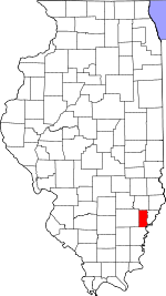
Edwards County, Illinois Basics:
Edwards County Illinois - Government Site
Population: 6,724
Area: 222 square miles
County seat: Albion
Area code(s) in use: 618
Time zone: CST
High school graduate or higher: 88.4%
Bachelor's degree or higher: 11.4%
Median household income: $39,238
Persons in poverty: 11.1%
Home ownership rate: 79.7%
Mean travel time to work: 21.5 minutes
Adjacent counties:
Gibson (IN) Posey (IN) Richland Wabash Wayne White
Places in Edwards County, Illinois
Nelson Private Airport,
West Salem Airport Burks Prairie,
Burnt Prairie,
English Prairie,
Frazier Prairie,
Long Prairie,
Village Prairie Dixon Shoals Base Line Bridge,
Dorsey Bridge,
Tait Bridge Albion Fire Department Rural Fire Protection District,
Bone Gap Rural Fire Protection District,
Browns Volunteer Fire Department,
Edwards County Courthouse,
Edwards County Emergency Medical Services,
West Salem City Hall,
West Salem Fire Department First Responders Albion Cemetery,
Baptist Cemetery,
Birk Prairie Cemetery,
Bond Cemetery,
Bone Gap Cemetery,
Brown Cemetery,
Brown Cemetery,
Browns Cemetery, Brush Prary Cemetery, Burke & Elder Cemetery, Campbell Cemetery,
Carney Cemetery,
Catholic Cemetery,
Coles Cemetery, Dry Cemetery, Ebenezer Cemetery, Elder Cemetery,
Ely Cemetery,
Enenezer Cemetery, Enenezer Cemetery,
Evangelical Cemetery,
Fortney Cemetery,
Gaede Cemetery,
Gould Cemetery,
Graceland Cemetery,
Gravet Cemetery, Grayville Cemetery,
Greathouse Cemetery,
Greathouse Cemetery, Haggard Cemetery, Huggins Cemetery,
Jacobs Cemetery,
James Hean Family Cemetery,
Johnson Cemetery,
Little Prairie Cemetery,
Little Wabash Cemetery,
Macedonia Cemetery,
Marion Cemetery,
Medler Cemetery, Miller Cemetery,
Moravian Cemetery, Morivian Cemetery,
Mount Zion Cemetery, Nine Mile Cemetery,
Oak Grove Cemetery,
Paul Cemetery,
Pinhook Cemetery,
Pleasant Hill Cemetery,
Potter Cemetery, Reicht Cemetery, Rice Cemetery,
Ridge Cemetery,
Samaria Cemetery,
Seventh Day Adventist Cemetery,
Shiloh Cemetery,
Thread Cemetery, Tomas Hill Cemetery, Trinity Cemetery,
Union Cemetery,
Wanborough Cemetery,
Wells Cemetery,
Welser Cemetery,
West Cemetery, West Salem Cemetery,
West Village Cemetery, Yankeetown Cemetery
Birk Prairie Church (historical),
Bone Gap Christian Church,
Bone Gap United Methodist Church,
Browns Chapel,
Ebenezer United Methodist Church,
Ellery Christian Church,
First Presbyterian Church of Albion,
Fortney United Methodist Church,
Free Methodist Church of Albion,
Little Prairie Christian Church,
Little Wabash Zion United Methodist Church,
Long Prairie Primitive Baptist Church,
Marion Christian Church,
Mount Zion United Methodist Church,
Northside Baptist Church,
Olive Congregational Christian Church,
Pleasant Hill Congregational Church,
Ridge Baptist Church,
Saint Johns Episcopal Church,
Salem Methodist Episcopal Church (historical),
Samaria Missionary Baptist Church,
Simpson United Methodist Church,
Union Congregational Church,
West Village Christian Church Albion Moose Lake Dam,
Harrison Lake Dam,
Krajec Lake Dam,
West Salem New Reservoir Dam Horseshoe Pond Seigert Station (historical) Albion East Oil Field,
Albion Oil Field,
Bone Gap Oil Field,
Parkersburg Oil Field Birkbeck Memorial,
Edwards County Fairgrounds,
Edwards County Memorial Plaza,
Public Square Albion,
Bennington,
Black,
Bone Gap,
Browns,
Grayville,
Lexington (historical),
Maple Grove,
Marion,
Mills Prairie (historical),
Piankashawtown (historical),
Red Top,
Samsville,
Wanborough (historical),
West Salem Ellery Post Office Albion Moose Lake,
Harrison Lake,
Krajec Lake,
Moose Lake,
West Salem New Reservoir,
West Salem Reservoir Albion Grade School,
Alfred School (historical),
Barnhart School (historical),
Blood School (historical),
Bond School (historical),
Brown School (historical),
Browns School (historical),
Burnt Prairie School (historical),
Curtisville School (historical),
Dixon School (historical),
Dunk School (historical),
Edwards County High School,
Flower School (historical),
Gates School (historical),
Gill School (historical),
Glover School (historical),
Hedrick School (historical),
Judge School (historical),
Mann School (historical),
Michels School (historical),
Mills Prairie School (historical),
Mitchell School (historical),
Montgomery School (historical),
Olive School (historical),
Persimmon Grove School (historical),
Red Top School (historical),
Ridge School (historical),
Severns School (historical),
Smith School (historical),
Vallette School (historical),
West Salem Grade School,
West Village School (historical),
Whites School (historical) Bear Creek,
Big Creek,
Buck Creek,
Butter Creek,
Camp Creek,
Crooked Creek,
Harper Creek,
Indian Creek,
Johnson Creek,
Little Indian Creek,
Madden Creek,
Mud Creek,
Negro Creek,
Onion Creek,
Parker Creek,
Shelby Creek,
Sugar Creek,
Walser Creek,
West Village Creek,

