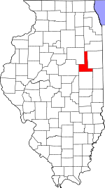
Ford County, Illinois Basics:


Ford County Illinois - Government Site

Population: 13,997
Area: 486 square miles
County seat: Paxton
Area code(s) in use: 815 217
Time zone: CST
High school graduate or higher: 88.0%
Bachelor's degree or higher: 17.0%
Median household income: $50,203
Persons in poverty: 9.9%
Home ownership rate: 78.3%
Mean travel time to work: 22.5 minutes


Adjacent counties:
Champaign  Iroquois  Kankakee  Livingston  McLean  Vermilion  

Find in Illinois

Map of the Ford County area


Our detail map of Ford County shows the Ford County, Illinois boundary lines and other interesting items.

Places in Ford County, Illinois

  Airports     show all on map

Barnes Landing Strip, Beherns Airport, Bradbury Airport, C D Maulding Airport, Clifford D Foster Airport, Gibson Community Hospital Heliport, Hasselbring Airport, John H Garrelts Airport, Otto Junior Airport, Paxton Airport, Read Airport, Roberts RLA Airport, Schertz Field Airport, Teds Place Airport, Wright Airport

  Buildings     show all on map

Elliott Volunteer Fire Department, Ford County Jail, Gibson City City Hall, Gibson City Fire Protection District, Gibson City Power Plant, Kempton Fire Protection District, Melvin Fire Protection District Melvin, Melvin Fire Protection District Roberts, Middlecoff Mansion, Moyer Library, Paxton Carnegie Library, Paxton City Hall, Paxton Fire Protection District, Piper City Fire Department, Sullivan Township Fire Protection District - Sibley Fire Department

  Canals     show all on map

Wall Town Drainage Ditch

  Cemeteries     show all on map

Blackford Cemetery, Brewton Cemetery, Drummer Township Cemetery, Farmersville Cemetery, Glen Cemetery, Hall Cemetery, Meharry Cemetery, Melvin Cemetery, Mona Township Cemetery, Mount Hope Cemetery, Mount Hope Cemetery, Mount Olivet Cemetery, Oregon Cemetery, Pells Park, Pleasant Grove Cemetery, Pontoppidan Cemetery, Prospect Cemetery, Saint Joseph Cemetery, Ten Mile Grove Cemetery, Trickle Grove Cemetery

  Churches     show all on map

American Lutheran Church, Bible Church, Church of Christ, Church of Christ (historical), Church of the Nazarene, Evangelical Covenant Church, Federated Church, First Baptist Church, First Christian Church, First Congregational Church (historical), First Lutheran Church, First Presbyterian Church, First Southern Baptist Church, Gibson City Pentecostal Church, Gibson City United Methodist Church, Kingdom Hall of Jehovahs Witnesses, Mount Olive Church, Our Lady of Lourdes Roman Catholic Church, Paxton Church of Christ, Paxton United Methodist Church, Pleasant Grove United Methodist Church, Pontoppidan Lutheran Church, Prairie Baptist Church, Saint Alfreds Chapel, Saint Marys Catholic Church, Saint Peter Catholic Church, Westminister Presbyterian Church

  Crossings     show all on map

Interchange 261

  Dams     show all on map

Laue Lake Dam

  Hospitals     show all on map

Gibson Area Hospital and Health Services, Gibson Manor Nursing Home, Paxton Community Hospital (historical)

  Lakes     show all on map

Lake Genevieve (historical), Lake Sibley

  Locales     show all on map

Beeset Station (historical), Cow Creek Farm, Glazik Farms, Grubbs Farms, Harvest Moon Drive-In, Hornstein Farms, Kendrick Farm, Kietzman's Farms, Moffett School, Mueller Farms, Railside Golf Club, Tjardes Farm

  Parks     show all on map

Belson Park, Fulton Park, LaFevre Park, Lowery Park, McMillen Baseball Park, North City Park, Prospect Cemetery Prairie Nature Preserve, South City Park

  Populated Places     show all on map

Cabery, Clarence, Derby, Elliott, Garber, Gibson City, Guthrie, Harpster, Kempton, Melvin, Paxton, Perdueville, Piper City, Proctor, Roberts, Sibley, Stelle

  Post Offices     show all on map

East Bend Post Office (historical), Eldredgeville Post Office (historical), Gibson City Post Office, Piper City Post Office, Sibley Post Office, Sugar Loaf Post Office (historical)

  Reservoirs     show all on map

Laue Lake

  Schools     show all on map

Adam School (historical), Alpha Omega School, Anderson School (historical), Ashley School (historical), Augustana College (historical), Bishop School (historical), Blackford School (historical), Blake School (historical), Blanchard School (historical), Burger School (historical), Center School (historical), Center School (historical), Clara Peterson Elementary School, Clayton School (historical), Columbia School (historical), Cothern School (historical), Crandall School (historical), Dehm School (historical), Donahue School (historical), Down School (historical), Drendel School (historical), Eclipse School (historical), Eden School (historical), Farmersville School (historical), Flagg School (historical), Froyd School (historical), Fuoss School (historical), Gallahue School (historical), Gibson City High School, Gibson City-Melvin-Sibley Elementary School, Gibson School (historical), Graham School (historical), Grand Prairie School (historical), Guthrie School (historical), Hall School, Heavisides School (historical), Herr School (historical), Hevener School (historical), Howell School (historical), Keighin School (historical), Kemp School (historical), Lake Shore School (historical), Larkin School (historical), Lily Dell School (historical), McDermott School (historical), McKinney School (historical), Meadow Mound School (historical), Miller School (historical), Minch School (historical), Miner School (historical), North Union School (historical), Ogilvie School (historical), Paxton High School, Paxton Public School (historical), Paxton-Buckley-Loda Junior High School, Pine Tree School (historical), Plainview School (historical), Pleasant Ridge School (historical), Pleasant Valley School (historical), Pleasant View School (historical), Put School (historical), Sand Ridge School (historical), Scott School (historical), Selock School (historical), Shute School (historical), Skeel School (historical), Smith School (historical), South Brenton School (historical), Strayer School (historical), Stringtown School (historical), Sullivan School (historical), Taylor School (historical), Tri-Point Elementary School, Tri-Point Junior High School, Trickel Grove School (historical), Victor School (historical), Wagner School (historical), Waite School (historical), Walnut Dell School (historical), West Point School (historical), White School (historical), Woodward School (historical), Zahn School (historical)

  Streams     show all on map

Big Four Ditch, Kelly Creek, West Branch Drummer Creek

  Towers     show all on map

WGCY-FM (Gibson City), WPXN-FM (Paxton)

  Woods     show all on map

Burr Oak Grove, Drummer Grove (historical), Heiting Grove, Sharps Grove (historical), Ten Mile Grove, White Oak Grove (historical),

Ford County, Illinois Population By Race (2012 estimate)

RacePopulation
WhiteFord County White population 13,66113,661  
MixedFord County Mixed population 140139
BlackFord County Black population 112111
AsianFord County Asian population 5655
American IndianFord County American Indian population 2827
Hawaiian & Pacific IslanderFord County Hawaiian & Pacific Islander population 00

Additional population tables :
State population table
Illinois population by county