Lawrence County, Illinois Basics:


Lawrence County Illinois - Government Site

Population: 16,592
Area: 372 square miles
County seat: Lawrenceville
Area code(s) in use: 618
Time zone: CST
High school graduate or higher: 77.7%
Bachelor's degree or higher: 9.5%
Median household income: $39,324
Persons in poverty: 13.6%
Home ownership rate: 73.4%
Mean travel time to work: 19.5 minutes

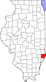
Adjacent counties:
Crawford  Knox (IN)  Richland  Wabash  

Find in Illinois

Map of the Lawrence County area


Our detail map of Lawrence County shows the Lawrence County, Illinois boundary lines and other interesting items.

Places in Lawrence County, Illinois

  Airports     show all on map

Dunlap Airport, Indian Heliport, Lawrence Co Memorial Hospital Heliport, Lawrenceville-Vincennes International Airport, Mount Carmel Municipal Airport, Piper's Landing Airport

  Areas     show all on map

Shoal Tract (historical)

  Bends     show all on map

King Bend

  Bridges     show all on map

Lincoln Memorial Bridge

  Buildings     show all on map

Blue Star Emergency Medical Services, Bridgeport Fire Protection District Station 1, Bridgeport Fire Protection District Station 2, Christy Fire Protection District Station 1, Christy Fire Protection District Station 2, Denison Fire Protection District Station 1, Denison Fire Protection District Station 2, Lawrence - Allison Fire Protection District, Lawrence - Allison Fire Protection District Station 2, Lawrence Correctional Center, Lawrence County Courthouse, Lawrence Public Libary, Lawrenceville City Hall, Lukin Townhall

  Canals     show all on map

Allison Ditch, Allison Ditch Number 2, Allison Ditch Number 3, Beaver Pond Ditch, Ditch Number 2, England Ditch, Otter Pond Ditch, Taylor Ditch

  Cemeteries     show all on map

Allison Cemetery, Bell Cemetery, Bethel Cemetery, Bluffs Cemetery, Brian Cemetery, Buchanan Cemetery, Bunker Hill Cemetery, Centerville Cemetery, Charlottesville Cemetery, Collins Cemetery, Conover Cemetery, Corrie Cemetery, Cotton Cemetery, Cughan Cemetery, Denison Cemetery, Derr Cemetery, Dollahan Cemetery, Emmons Cemetery, Gilead Cemetery, Goines Cemetery, Hollister Cemetery, Hopewell Cemetery, Howard Cemetery, Immaculate Conception Cemetery, Kinkade Cemetery, Lagow Cemetery, Lawrenceville Cemetery, Leech Cemetery, Lone Tree Cemetery, May Chapel Cemetery, Mickey Cemetery, Moffett Cemetery, Morris Cemetery, Mount Zion Cemetery, Oak Lawn Cemetery, Olive Branch Cemetery, Otterbein Cemetery, Otterburn Cemetery, Pollard Cemetery, Portee Cemetery, Portee Cemetery, Price Cemetery, Ridgley Cemetery, Saint Paul Cemetery, Shiloh Cemetery, Spring Hill Cemetery, Storckman Cemetery, Sumner Cemetery, Tann Cemetery, Tevealt Cemetery, Wesley Chapel Cemetery, Wright Cemetery

  Census     show all on map

Birds Census Designated Place

  Churches     show all on map

Bee Branch Church, Bethany Church, Bethel Church, Bethel Church, Beulah Church, Billett United Methodist Church, Bridgeport Church of God, Buchanan Church, Centenary Church, Church of the Brethren, East Pinkstaff Church, Fairview Church, Faith Church of the Nazarene, First Baptist Church, First Christian Church, First Christian Church, First Church of God, First Presbyterian Church, First Presbyterian Church, First United Methodist Church, First United Methodist Church, Free Methodist Church, Free Methodist Church, Gilead Church, Hi-Way Church of God, Immaculate Conception Roman Catholic Church, Island Church, Liberty Church, May Chapel, Mount Zion Church, Mount Zion Church, Olive Branch Church, Otterbein United Methodist Church, Our Savior Lutheran Church, Pisgah Church, Pleasant Hill Church, Pleasant Hill Church, Pleasant Ridge Church, Prairie Chapel, Red Hills Chapel, Rising Sun Church, Saint Francis Xavier Catholic Church, Saint Lawrence Catholic Church, Shiloh Baptist Church, Union Chapel United Methodist Church, Zion United Methodist Church

  Dams     show all on map

Red Hills State Park Lake Dam

  Hospitals     show all on map

Lawrence County Memorial Hospital

  Lakes     show all on map

Beaver Pond, Garvey Pond, Lake Lawrence, Miller Pond, Rapid Pond, Robeson Pond

  Locales     show all on map

Beman (historical), Raccoon Ridge Campground, Sumner Landfill, Veterans Point Picnic Area

  Oilfields     show all on map

Lawrence Oil and Gas Field, West Ruark Oil Field

  Parks     show all on map

Chauncey Marsh Nature Preserve, Lanterman Park, Lincoln Trail State Memorial, Red Hills State Park, Red Hills Woods Nature Preserve, Robeson Hills Nature Preserve

  Populated Places     show all on map

Applegate, Billett, Birds, Bridgeport, Charlottsville (historical), Chauncey, Grays Corner, Grisold (historical), Hadley, Helena, Jackson, Lawrenceville, Petersburg, Petrolia, Pinkstaff, Riddleville, Russellville, Saint Francisville, Sand Barrens, Sumner, Westport, Westport

  Post Offices     show all on map

Allison Post Office (historical), Lawrenceville Post Office, Pinkstaff Post Office

  Reservoirs     show all on map

Red Hills Lake, Red Hills State Park Lake

  Schools     show all on map

Arlington Elementary School, Bellewood School (historical), Bethany School (historical), Beulah School (historical), Billett School (historical), Bond School (historical), Brick School Number 3 (historical), Bridgeport Grade School, Brookside Elementary School, Buchanan School (historical), Buckhorn School (historical), Bunker Hill School (historical), Center School (historical), Centerville School (historical), Central Elementary School, Clark School (historical), Cleveland School (historical), Collins School (historical), Conover School (historical), Crossroads School (historical), East Pinkstaff School (historical), Fairview School (historical), Fillmore School, Ford School (historical), Franklin School (historical), Fremont School (historical), Frogeye School (historical), Fyffe School (historical), Gadd School (historical), Grant School (historical), Grass School (historical), Hadley School (historical), Harmony School (historical), Hazel Dell School (historical), Hazledale School (historical), Holliday School (historical), Hutton School, Island School (historical), Lafayette School (historical), Lawrenceville High School, Leech School (historical), Liberty School (historical), Lincoln Elementary School, Maple Grove School (historical), Miller School (historical), Mohn School (historical), North Center School (historical), Parkview Junior High School, Petty Elementary School, Petty School (historical), Pinhook School (historical), Pinhook School (historical), Plank Road School (historical), Pleasant Grove School (historical), Pleasant Ridge School (historical), Pleasant Ridge School (historical), Pleasant View School (historical), Prairie School (historical), Prairie School (historical), Red Hill High School, Rich Valley School (historical), Rising Sun School (historical), Saint Francisville Elementary School, Saint Lawrence School, Sand Barrens School (historical), Sand Ridge School, Seed Elementary School, Seymour School (historical), Shiloh School (historical), Spring Hill School (historical), Sumner Attendence Center, Union School (historical), Union School (historical), Union School (historical), Union School (historical), Valley School (historical), Wabash School (historical), Washington School, Waters School (historical), White School (historical), Whiteoak School (historical)

  Springs     show all on map

Stiver Springs

  Streams     show all on map

Bee Branch, Big Slough, Birch Creek, Brushy Creek, Bugaboo Creek, Carter Creek, Crab Apple Creek, Crabapple Creek, Crow Branch, Eagle Branch, Embarras River, Flat Branch, Indian Creek, Mad Creek, Muddy Creek, Old Channel Embarras River, Paul Creek, Raccoon Creek, Seed Creek, Shirley Creek, Storckman Creek, Sugar Creek, The Slough

  Summits     show all on map

Red Hill, Robeson Hills

  Towers     show all on map

WAKO-AM (Lawrenceville), WAKO-FM (Lawrenceville),

Lawrence County, Illinois Population By Race (2012 estimate)

RacePopulation
WhiteLawrence County White population 14,65114,650  
BlackLawrence County Black population 1,6591,659
MixedLawrence County Mixed population 166165
American IndianLawrence County American Indian population 5049
Hawaiian & Pacific IslanderLawrence County Hawaiian & Pacific Islander population 00

Additional population tables :
State population table
Illinois population by county