McDonough County, Illinois Basics:


McDonough County Illinois - Government Site

Population: 32,572
Area: 589 square miles
County seat: Macomb
Area code(s) in use: 309
Time zone: CST
High school graduate or higher: 91.4%
Bachelor's degree or higher: 32.9%
Median household income: $35,812
Persons in poverty: 22.3%
Home ownership rate: 61.0%
Mean travel time to work: 15.3 minutes
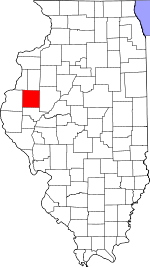
Adjacent counties:
Fulton  Hancock  Henderson  Schuyler  Warren  

Find in Illinois

Map of the McDonough County area


Our detail map of McDonough County shows the McDonough County, Illinois boundary lines and other interesting items.

Places in McDonough County, Illinois

  Airports     show all on map

Clark Airport, Dowacter Airport, Giles Griswold Airport, Macomb Municipal Airport, McDonough County Hospital Heliport, Palmer Airport, Prairie City Airport, Runyan Aviation Airport, Smith Airport, Willow Grove Landing Strip

  Areas     show all on map

Round Prairie, The Thousand Acres

  Bridges     show all on map

Cow Ford Bridge, Holler Bridge, Lamoine Bridge

  Buildings     show all on map

Bayliss Hall, Bennett Hall, Blandinsville - Hire Fire Protection District, Blandinsville-Hire Community Center, Brooks Cultural Center, Brophy Hall, Browne Hall, Bushnell Fire Protection District Station 1, Bushnell Fire Protection District Station 2, Clarence Kleinkopf Round Barn, Colchester Fire Protection District, Corbin Hall, Currens Hall, Eisenhower Tower, Eldorado Townhall, Emmet - Chalmers Fire Protection District, Emmet Townhall, Garwood Hall, Good Hope - Sciota Fire Protection District Station 1, Good Hope - Sciota Fire Protection District Station 2, Henninger Hall, Higgins Hall, Hire Townhall, Horrabin Hall, Hursh Hall, Industry Fire Protection District, Knoblauch Hall, Lincoln Hall, Macomb City Hall, Macomb Fire Department Station 1, Macomb Fire Department Station 2, Macomb Police Department, Macomb Public Library, McDonough County Courthouse, McDonough County Jail, McDonough County Orphanage (historical), Memorial Hall, Morgan Hall, Mound Townhall, Mowbray Hall, New Salem Fire Protection District, Olson Confernece Center, Prairie City Fire Protection District, Prairie Land Community Center (historical), Sallee Hall, Scotland Townhall, Seal Hall, Sherman Hall, Simpkins Hall, Stipes Hall, Tanner Hall, Thompson Hall, Tillman Hall, University Union, Waggoner Hall, Washington Hall, Western Hall, Wetzel Hall

  Cemeteries     show all on map

Anderson Cemetery, Archer-Bethel Cemetery, Argyle Cemetery, Atkinson Cemetery, Bailey Cemetery, Banks Cemetery, Barber Cemetery, Bardolph Cemetery, Bardolph Old Cemetery, Bean Cemetery, Beckelhymer, Bethel Baptist Cemetery, Bowman Cemetery, Brooking Cemetery, Bushnell City Cemetery, Camp Creek Cemetery, Central Cemetery, Chapel Cemetery, Chockley Cemetery, Clark-Evans-Woods Cemetery, Claybough Cemetery, Cost Cemetery, Craig Cemetery, Crossroads Cemetery, Dennis Cemetery, Doddsville Cemetery, Drowing Fork Cemetery, Duncan Cemetery, Dunkard Cemetery, Dunsworth Cemetery, Dye Cemetery, Family Cemetery, Forest Lawn Cemetery, Foster Point Cemetery, Friendship Cemetery, Gibson Cemetery, Glade City Cemetery, Good Hope Cemetery, Gunning Cemetery, Guy Cemetery, Hageman Cemetery, Hainline Cemetery, Harris Cemetery, Harris Cemetery, Hays Cemetery, Head Cemetery, Herron Cemetery, Hickory Grove Cemetery, Hills Grove Cemetery, Hillsborough Cemetery, Hoagland Cemetery, Hutchinson Cemetery, Industry City Cemetery, Jacoby Grave, King Tabler Cemetery, Lansdown Cemetery, Larkins Cemetery, Liberty Cemetery, Lower Cemetery, Macomb Cemetery, Miler Grave, Miles Cemetery, Moore Cemetery, Moore Cemetery, Mound Cemetery, Mound Cemetery, Mount Auburn Cemetery, Mourning Cemetery, Murray Grave, Mustain Cemetery, Naylor Cemetery, Nayor Cemetery, Neese Cemetery, Nubbin Ridge Cemetery, Oakwood Cemetery, Old Bedford Cemetery, Old Catholic Cemetery, Old Macomb Cemetery, Old Plymoth Cemetery, Pearce Cemetery, Peck Cemetery, Pennington Cemetery, Pennington Number 1 Cemetery, Pennington Point Cemetery, Pleasant Grove Cemetery, Post Shippey Cemetery, Prairie City Cemetery, Pruitt Cemetery, Riden Cemetery, Rigg Cemetery, Robinson Cemetery, Sacred Heart Cemetery, Saint Pauls Cemetery, Scott Cemetery, Simpson Cemetery, Solon-Robinson Cemetery, South Cemetery, Spring Creek Cemetery, Spring Grove Cemetery, Standard Cemetery, Stevens Cemetery, Stickle Cemetery, Stoneking Cemetery, Stoneking Cemetery, Strader Cemetery, Sullivan Cemetery, Vail Cemetery, Vance Cemetery, Vawter Cemetery, Walker Cemetery, Walnut Grove Cemetery, Warmack Cemetery, Wayland Cemetery, Waymack Cemetery, White Cemetery, White Flock Cemetery, Wilhelm Cemetery, Willey Cemetery, Wilson Cemetery, Wilson Cemetery

  Census     show all on map

Adair Census Designated Place, Georgetown Census Designated Place

  Churches     show all on map

Adair United Brethren Church (historical), Adair United Methodist Church (historical), Aldersgate Free Methodist Church, Apostolic Lighthouse (historical), Argyle Bible Church, Argyle Cumberland Presbyterian Church (historical), Bardolph Cumberland Presbyterian Church (historical), Bardolph Presbyterian Church, Bardolph United Methodist Church, Blandinsville United Methodist Church, Brown Chapel (historical), Bushnell Assembly of God Church, Bushnell Baptist Chapel (historical), Bushnell Christian Church, Bushnell United Methodist Church, Calvary Baptist Church, Camp Creek Church of the Brethren (historical), Cedar Creek Baptist Church (historical), Center Church, Christian Endeavor Chapel (historical), Christian Faith Center (historical), Church of Christ, Church of God Abrahamic Faith, Church of the Nazarene, Church of the Nazarene, Colchester United Methodist Church, Cottonwood Baptist Church (historical), Covenant Presbyterian Church, Doddsville Community Methodist Church, Doddsville Presbyterian Church (historical), Duncan Church (historical), Dutch Reformed Church (historical), Eagle Community Church, Eagle Free Methodist Church (historical), East Bethel Methodist Church, Ebenezer Presbyterian Church, Elm Grove United Brethren Church (historical), Faith Fellowship Chapel (historical), Faith Temple Assembly of God Church, Faith United Methodist Church, Fandon Christian Church, First Baptist Church, First Baptist Church, First Baptist Church, First Baptist Church of Blandinsville, First Born Church of the Living God (historical), First Christian Church, First Christian Church, First Church of Christ Scientist, First Church of God (historical), First Missionary Baptist Church, First United Presbyterian Church, First United Presbyterian Church, Friendship United Methodist Church, German Methodist Episcopal Church (historical), Good Hope United Methodist Church, Hills Grove United Methodist Church, Hillsborough Baptist Church (historical), Holiness Outreach Ministry, Immanauel Lutheran Church, Industry Assembly of God Church, Industry United Methodist Church, Jackson Street Cumberland Presbyterian Church (historical), Jerusalem United Methodist Church, Kingdom Hall of Jehovahs Witnesses, Korean United Methodist Church, Lamoine Chapel (historical), Liberty Christian Church (historical), Liberty Methodist Episcopal Church (historical), Lynn Grove Methodist Episcopal Church (historical), Macomb Alliance Church (historical), Macomb Assembly of God Church, Macomb Free Methodist Church (historical), Maple Avenue Christian Church, Mound Chapel Methodist Church (historical), Mound United Brethren in Christ Church (historical), Mount Calvary Church of God in Christ, Mount Carmel Cumberland Presbyterian Church (historical), Mount Pisgah Evangelical Lutheran Church (historical), Mount Zion Free Methodist Church (historical), New Bradford Christian Church (historical), New Philadelphia United Methodist Church, New Salem Christian Church (historical), Old Bedford Christian Church, Pennington Point Methodist Church (historical), Pilot Grove United Brethren Church (historical), Pleasant Gale United Brethren Church (historical), Pleasant Grove Methodist Episcopal Church (historical), Pleasant Mound Methodist Episcopal Church (historical), Pleasant View Methodist Episcopal Church (historical), Prairie City Community Church (historical), Prairie City Methodist Episcopal Church (historical), Prairie City Presbyterian Church, Prairieland Open Bible Center, Rock Creek Methodist Episcopal Church (historical), Sacred Heart Catholic Church, Saint Bernard Catholic Church, Saint Georges Episcopal Church, Saint Pauls Catholic Church, Salem Meeting House of the Brethren in Christ (historical), Salem Methodist Episcopal Church (historical), Scotland Trinity Presbyterian Church, Scott Church, Second Baptist Church (historical), Shiloh Presbyterian Church (historical), Stickle Methodist Episcopal Church (historical), Sugar Creek Cumberland Prestyterian Church (historical), Tennessee United Methodist Church, The Church of Jesus Christ of Latter Day Saints, Trinity Evangelical Lutheran Church, Trinity Methodist Church, Union Church (historical), Union Church (historical), Universalist Church of Macomb (historical), University Baptist Church, Victory Baptist Church, Walnut Grove United Methodist Church, Wesley Chapel (historical), Wesley United Methodist Church, West Bethel Baptist Church, West Prairie Cumberland Presbyterian Church, White Flock Congregational Church (historical), Willow Grove Evangelical United Brethren Church (historical)

  Dams     show all on map

Argyle Lake Dam, Blandinsville City Lake Dam, Cricketwood Green Lake Dam, Irish Lake Dam, Patrick Lake Dam, Spring Lake Dam, Vermont New Lake Dam

  Hospitals     show all on map

Beu Health Center, Elms Nursing Home, McDonough County Rehabilitation Center, McDonough District Hospital, Sprucewood Healthcare Center

  Lakes     show all on map

Colmar Lake, Lake Ruth

  Locales     show all on map

Camp Chic-A-Gami, Campers Hill Campground, Gold Hills Golf Course, Hickory Grove Corner, Macomb City Waterworks, Macomb Country Club, Mcdonough County Poor Farm (historical), O L Champion Golf Course, Pearl Camp, Twin Oaks Country Club, University Point Campground

  Mines     show all on map

Colchester Quarry, McClure Quarries

  Oilfields     show all on map

Colmar-Plymouth Oil Field

  Parks     show all on map

Argyle Hollow Barrens Nature Preserve, Argyle Lake State Park, Chandler Park, Compton Park, Downing Park, Everly Park, Friendship Park, Glenwood Park, Hanson Field, Patton Park, Prairie City Park, Veterans Memorial Park

  Populated Places     show all on map

Adair, Bardolph, Blandinsville, Bushnell, Colchester, Colmar, Doddsville, East Village, Fandon, Georgetown, Good Hope, Hills Grove (historical), Industry, Lamone Village, Little Ireland (historical), Macomb, New Philadelphia, Pennington Point, Prairie City, Ragtown (historical), Sciota, Scottsburg, Shoo Fly, Spring Creek Settlement (historical), Stewardsville (historical), Tennessee, University Village, Walnut Grove

  Post Offices     show all on map

Bushnell Post Office, Macomb Post Office, Siesta Post Office (historical)

  Reservoirs     show all on map

Argyle Lake, Blandinsville City Reservoir, Cricketwood Green Lake, Irish Lake, Lake Michale, Patrick Lake, Spring Lake, Vermont New Lake

  Ridges     show all on map

Gin Ridge

  Schools     show all on map

Adair Community High School (historical), Bardolph High School (historical), Bean School (historical), Birds School (historical), Blandinsville School (historical), Blazer School (historical), Brickyard School (historical), Brock School (historical), Browns School (historical), Browns School (historical), Buncombe School (historical), Burnsville School (historical), Bushnell-Prairie City Elementary School, Bushnell-Prairie City High School, Camp Creek School (historical), Cane Patch School (historical), Centennial School (historical), Center Point School (historical), Center School (historical), Center School (historical), Center School (historical), Chalkey School (historical), Cherry Grove School (historical), Coker School (historical), Colchester Elementary School, Colchester High School, Colchester Junior High School, Coloma School (historical), Cottage Corner School (historical), Cottonwood School (historical), Crabb School (historical), Crowl School (historical), Crown Point School (historical), Curtis School (historical), Deckers School (historical), Dixie School (historical), Eagle School (historical), East Bethel School (historical), East School (historical), Ebenezer School (historical), Edison Junior High School, Egypt School (historical), Elm Grove School (historical), Emory School (historical), Excelsior School (historical), Fairmont School (historical), Fairview School (historical), Fandon School (historical), Foster Point School (historical), Foster School (historical), Franklin School (historical), Frog Pond School (historical), Frogpond School (historical), Gooseneck School (historical), Grant Elementary School, Guy School (historical), Hagan School (historical), Hainline School (historical), Hamilton School (historical), Hanson School (historical), Hardscrabble School (historical), Harmony School (historical), Harris School (historical), Harvey School (historical), Hickory Grove School (historical), Hicks School (historical), Hills Grove School (historical), Horn Field Campus, Hume School (historical), Huston Lawn School (historical), Independence School (historical), Industry Elementary School, Industry High School, Jackson School (historical), Jones School (historical), Lawyer School (historical), Liberty School (historical), Lincoln Elementary School, Litchfield School (historical), Locust School (historical), Logan Elementary School, Lombard School (historical), Long Nine School (historical), Lynn Grove School (historical), MacArthur Elementary School, Macomb Female Seminary (historical), Macomb High School, Maguire School (historical), Maple Grove School (historical), Maple Grove School (historical), Martin School (historical), Martin School (historical), McKamey School (historical), McKee School (historical), McNair School (historical), Mound School (historical), Mount Holly School (historical), Mount Pleasant School (historical), Mount Solan School (historical), Mount Zion School (historical), Mud Acre School (historical), Muddy Lane School (historical), Nevada School (historical), New Era School (historical), New Philadelphia School (historical), North School (historical), Northwestern Elementary School, Northwestern High School, Northwestern Junior High School, Oakwood School (historical), Pennington Point School (historical), Pilot Grove School (historical), Pittinger School (historical), Pleasant Grove School (historical), Pleasant Grove School (historical), Possum Hollow School (historical), Prairie City High School (historical), Prairie School (historical), Presbyterian School (historical), Price School (historical), Rabbit Burrow School (historical), Ragtown School (historical), Railroad School (historical), Rich School (historical), Robin Glenn School (historical), Rock Creek School (historical), Runkle School (historical), Saint Paul School, School Number 16 (historical), School Number 16 (historical), School Number 5 (historical), School Number 84, Scottsburg School (historical), Shanghai School (historical), Spiker School (historical), Spoon River College Extension, Stickler School (historical), Stookey School (historical), Sunnyside School (historical), Tennessee School (historical), Thompson College School (historical), Timber School (historical), Union School (historical), Union School (historical), Victor School (historical), Ward School (historical), West Bethel School (historical), West School, Western Academy (historical), Western Illinois University, Wetzel School (historical), White Flock School (historical), Wiley School (historical), Willow Grove School (historical), Willow Grove School (historical), Wilson Elementary School, Yard School (historical), Yokum School (historical)

  Springs     show all on map

Vishnu Springs

  Streams     show all on map

Beckford Branch, Camp Creek, Carter Creek, Drowning Fork, Farmers Fork, Grindstone Creek, Hogwallow Branch, Kepple Creek, Killjordan Creek, Little Creek, North Fork East Fork La Moine River, Short Fork, Snakeden Branch, Spring Creek, Town Fork, Troublesome Creek, Wolfden Branch

  Summits     show all on map

Dyers Mound

  Towers     show all on map

WIUM-FM (Macomb), WIUS-FM (Macomb), WJEQ-FM (Macomb), WKAI-FM (Macomb), WKAI-FM (Macomb), WLRB-AM (Macomb), WMEC-TV (Macomb), WSRQ-FM (Bushnell)

  Trails     show all on map

Cut Off Trail

  Valleys     show all on map

Argyle Hollow, Wigwam Hollow,

McDonough County, Illinois Population By Race (2012 estimate)

RacePopulation
WhiteMcDonough County White population 29,51029,510  
BlackMcDonough County Black population 1,7591,758
AsianMcDonough County Asian population 651651
MixedMcDonough County Mixed population 554553
American IndianMcDonough County American Indian population 9897
Hawaiian & Pacific IslanderMcDonough County Hawaiian & Pacific Islander population 00

Additional population tables :
State population table
Illinois population by county