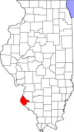
Monroe County, Illinois Basics:
Monroe County Illinois - Government Site
Population: 33,310
Area: 385 square miles
County seat: Waterloo
Area code(s) in use: 618
Time zone: CST
High school graduate or higher: 92.9%
Bachelor's degree or higher: 25.5%
Median household income: $71,033
Persons in poverty: 4.9%
Home ownership rate: 82.0%
Mean travel time to work: 29.3 minutes
Adjacent counties:
City of St. Louis (MO) Jefferson (MO) Randolph St. Clair St. Louis (MO) Ste. Genevieve (MO)
Places in Monroe County, Illinois
Crook RLA Airport,
Duclos RLA Airport,
King Airport,
Our Lady Immaculata Airport,
Quint/King Heliport,
Ralph Jacobs Airport,
Ralph Jacobs Airport,
Sackman Field Airport,
Smith RLA Airport,
Smith RLA Airport Columbia Emergency Medical Services,
Columbia Volunteer Fire Department, Durfee Post Light,
Hecker Fire Protection District,
Maeystown Volunteer Fire Department,
Monroe County Ambulance,
Monroe County Courthouse,
Monroe County Fire Department,
Morrison-Talbott Library,
Valmeyer Fire Protection District,
Waterloo Community Rural Fire Protection District Fults Creek Ditch,
Selma Ditch Penitentiary Point Brickey Cemetery,
Burksville Cemetery,
City Cemetery,
Deer Hill Cemetery, Devore Cemetery,
Dick Cemetery,
Eagle Cliff Cemetery, Eilers Cemetery, Fanning Joseph Cemetery, Flatford Cemetery, Gaines Cemetery, Gibbons Cemetery,
Gilmore Cemetery,
Grant Pass Cemetery, Gravel Springs Cemetery, Hall John W Cemetery, Halligan Rosa Cemetery, Harvey Cemetery,
Hecker Cemetery, Hembough John Cemetery, Hembrough Richard Cemetery, Hoagland Louisa Cemetery,
Holy Cross Cemetery,
Holy Cross Cemetery,
Holy Cross Cemetery, Horrell Cemetery, Huffaker Cemetery,
Immaculate Conception Cemetery,
Immanuel Cemetery, Jameserson Cemetery,
Koch Cemetery,
Kolmer Cemetery,
Lemen Cemetery,
Madonnaville Cemetery,
Martini Cemetery,
McConkey Cemetery,
Monroe City Cemetery,
Moores Cemetery,
New Design Historical Cemetery,
New Hanover Cemetery,
Palmer Cemetery,
Rebenack Cemetery,
Saint Johns Cemetery,
Saint Johns Cemetery,
Saint Johns Cemetery,
Saint Marcus Cemetery,
Saint Marys Cemetery,
Saint Pauls Cemetery,
Saints Peter and Paul Cemetery,
Shoemaker Cemetery,
Studt Cemetery,
Wallace Cemetery, Woodson Garden Cemetery,
Zion Cemetery Bethany United Church,
Church of God,
Concord Presbyterian Church,
Deer Hill Church,
First Baptist Church of Waterloo,
First Church,
Friedens United Church of Christ,
Holy Cross Church,
Immanuel Church (historical),
Immanuel Lutheran Church,
Johanna Church (historical),
Kingdom Hall,
Saint Augustine Catholic Church,
Saint Johns Church (historical),
Saint Marcus Chapel,
Saint Pauls Church,
Saints Peter and Paul Catholic Church,
Salem Church,
The Church of Jesus Christ of Latter Day Saints,
Tiptown Church (historical),
Zoar Church Interchange 6 Columbia Sportsman Club Lake Dam,
Hill Lake Dam,
Illinois No Name Number 2020 Dam,
Illinois No Name Number 2027 Dam,
Lake Emmett Dam,
Lake Loudel Dam,
Lake Mildred Dam,
Lake Ronnie Dam,
Waterloo New Reservoir Dam,
Waterloo Reservoir Number 1 Dam,
Waterloo Reservoir Number 2 Dam,
Waterloo Sportsman Club Lake Dam Number 1,
Waterloo Sportsman Club Lake Dam Number 2 Lucas Slough Beagles Island,
Calico Island,
Carroll Island (historical),
Meissner Island Beaver Lake,
Bissell Lake,
Branch Lake (historical),
Fish Lake,
Foster Pond,
Fox Lake,
Gilmore Lake,
Hill Lake (historical),
Howe Lake (historical),
Island Lake,
Lake Mildred,
Long Lake,
Luhrwood Lakes,
Moredock Lake,
Porter Lake,
Rainer Lake,
Saunders Lake (historical),
Sawmill Lake,
Shaus Lake,
Steppig Lake,
Stubblefield Lake,
Timber Lake,
Twin Lakes,
Vogt Lake,
Waddle Lake (historical),
Wetzler Lake Camp Vanderventer,
Camp Wartburg,
Escarda Dairy,
Harrisonville Landing,
Kemper Landing,
Leber Stock Farm,
Maeys,
New Hanover Station,
Renault Station,
Schmeltz Stock Farm Nike Site SL-40C (historical),
Nike Site SL-40L (historical) Bolm Schkraft Park,
Fogelpole Cave Nature Preserve,
Fults Hill Prairie Nature Preserve,
Illinois Caverns State Natural Area,
Maeystown Historic District,
Waterloo Historic District Ames,
Burksville,
Burksville Station,
Chalfin Bridge,
Columbia,
Foster Pond (historical),
Fountain,
Fountain Gap,
Fults,
Harrisonville,
Hecker,
Ivy,
Kidd,
Kise Crossing,
Lemens,
Madonnaville,
Maeystown,
Merrimac,
Millstadt Junction,
Mitchie,
Monroe City,
New Hanover,
Renault,
Saint Joe,
Saint Philip (historical),
Tipton,
Valmeyer,
Warnock,
Wartburg,
Waterloo,
Woodville (historical) Columbia Post Office,
Renault Post Office,
Valmeyer Post Office,
Valmeyer Post Office,
Waterloo Post Office Columbia Sportsman Club Lake,
Hill Lake,
Lake Emmett,
Lake Loudel,
Lake Ronnie,
Stone Lake,
Waterloo New Reservoir,
Waterloo Reservoir Number 1,
Waterloo Reservoir Number 2,
Waterloo Sportsman Club Lake Tamarawa Ridge Baum School (historical),
Blackburn School (historical),
Bluff School (historical),
Boxtown School (historical),
Brickey School (historical),
Burksville School (historical),
Central School,
Clifford School (historical),
Collier School (historical),
Columbia Elementary School,
Columiba High School,
Copp School (historical),
Deer Hill School (historical),
Etter School (historical),
Gall School (historical),
Gibault High School,
Goeddeltown School (historical),
Grant School (historical),
Hayden School (historical),
Holcomb School (historical),
Holy Cross School,
Kennif School (historical),
Kirsch School (historical),
Lohrberg School (historical),
Long Lake School (historical),
Martini School (historical),
Maus School (historical),
McBride School (historical),
McQuillan School (historical),
Miles Hollow School,
Mitchie School (historical),
Mueller School (historical),
O'Leary School (historical),
Oak Grove School (historical),
Old Rock School,
Poe School (historical),
Portland School,
Posten School (historical),
Riverview School (historical),
Rockhouse School,
Round Prairie School (historical),
Saint Augustine Catholic School,
Sand Bank School (historical),
Schroeder School (historical),
Shoemaker School (historical),
Stringtown School (historical),
Upper School (historical),
Valmeyer Community School,
Varnum School (historical),
W J Zahnow Elementary School,
Walnut Grove School,
Waterloo High School,
Waterloo Junior High School,
Yankeetown School (historical) Terry Spring Andys Run,
Bond Creek,
Bradley Branch,
Carr Creek,
Dry Fork,
Dry Run,
Fountain Creek,
Fults Creek,
Gerhardt Creek,
Hesterburg Creek,
Hill Creek,
Hill Lake Creek,
Kopp Creek,
Little Carr Creek,
Long Slash Creek,
Maeystown Creek,
Monroe City Creek,
Old Maeystown Creek,
Onemile Race Creek,
Palmer Creek,
Prairie Branch,
Prairie du Long Creek,
Richland Creek,
Rockhouse Creek,
Rocky Branch,
South Fork Horse Creek,
Walters Creek,
Wilson Creek Potato Hill Cavanah Lake Dennis Hollow,
Monroe City Hollow,
Morrison Hollow,
Schaeffer Hollow,
Trout Hollow,

